envelope
https://search.heritageburnaby.ca/link/museumartifact13092
- Repository
- Burnaby Village Museum
- Accession Code
- BV985.4485.1
- Description
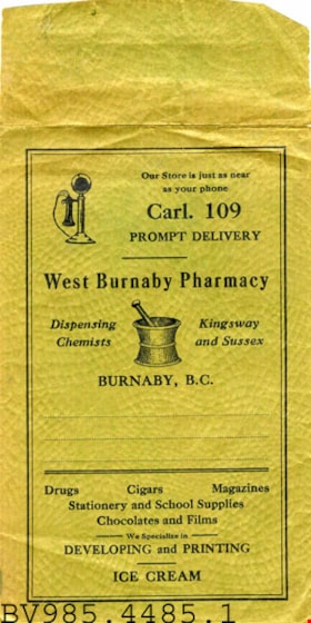
- West Burnaby Pharmacy - Envelope. Olive green envelope from the West Burnaby Pharmacy on Kingsway and Sussex. The envelope has the store delivery number posted on the top for "Prompt Delivery". The pharmacy sells drugs, cigars, magazines, stationary and school supplies, chocolate, films and ice cream. There is also a developing and printing service. The envelope has two illustrations printed on it, one of a telephone in the top left corner and one of a mortar and pestle in the middle. The envelope measures 20cm (including flap) x 10cm.
- Classification
- Written Communication T&E - - Writing Accessories
- Object Term
- Envelope, Shipping
- Names
- West Burnaby Pharmacy
- Geographic Access
- Kingsway
- Street Address
- 4687 Kingsway
- Historic Neighbourhood
- Central Park (Historic Neighbourhood)
Images

exercise book
https://search.heritageburnaby.ca/link/museumartifact41181
- Repository
- Burnaby Village Museum
- Accession Code
- BV985.5994.1
- Description
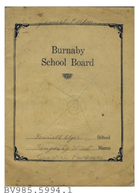
- Burnaby School Board - Exercise Booklet - [192-?]. School exercise booklet for Kenneth Alger at Kingsway West School in Burnaby. The booklet was produced by the Burnaby School Board. The booklet was for General Purpose and was not dedicated to one particular subject. There are little drawings throughout the booklet along with course work.
- Names
- Kingsway West School
- Geographic Access
- Kingsway
Images
pennant
https://search.heritageburnaby.ca/link/museumartifact46519
- Repository
- Burnaby Village Museum
- Accession Code
- BV004.7.4
- Description
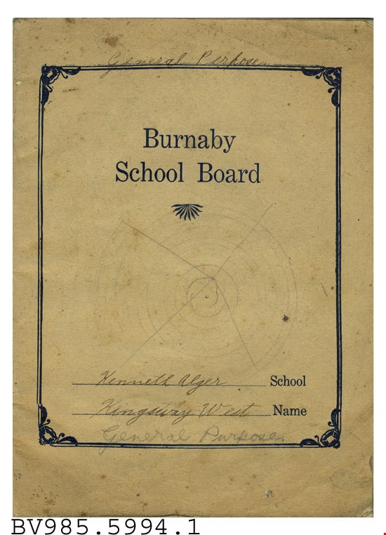
- This is a triangular shaped, maroon, felt pennant with gold lettering and the edge of the badge outlined in gold. The lettering is arranged vertically to the point of the pennant, except for "Kingsway West Sports" which slopes left to right.
- Object History
- Object purchased by BVM in 2004.
- Marks/Labels
- "KINGSWAY WEST SPORTS" (on an angle), printed "1940", printed "SECOND", printed, vertical
- Measurements
- L: 12.5 cm
- Names
- Kingsway West School
- Geographic Access
- Kingsway
Images

postcard
https://search.heritageburnaby.ca/link/museumartifact84670
- Repository
- Burnaby Village Museum
- Accession Code
- BV007.43.3
- Description
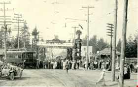
- [Duke of Connaught] - Postcard -- [1912]. Postcard with a black and white photograph of the arrival of the Duke of Connaught, then Governor General of Canada. The image was taken at Edmonds and Kingsway with a welcome arch and a banner reading "Burnaby Welcomes You". In the image there is the interurban tram and Edmonds station in the background, surrounded by many onlookers. Verso of postcard includes stamp at top reading: "CANADIAN SOUVENIR POST CARD"; divided into two sections "THIS SPACE FOR CORRESPONDENCE" / "THIS SPACE FOR ADDRESS ONLY"; includes marking to place postage stamp "POSTAGE / ONE CENT / FOR / CANADA / AND U.S. / TWO CENTS / FOR / ABROAD". Annotation in pencil on verso of postcard reads: "Sept 21 / 1912 / Duke of Connaught / at Edmonds and / Kingsway"
- Object History
- Souvenir photograph postcard documents the Duke of Connaught's visit to Burnaby in 1912.
- Classification
- Written Communication T&E - - Writing Media
- Object Term
- Postcard
- Colour
- Black
- White
- Measurements
- w: 14 cm h: 9 cm
- Geographic Access
- Edmonds Street
- Kingsway
- Historic Neighbourhood
- Edmonds (Historic Neighbourhood)
- Planning Study Area
- Richmond Park Area
Images
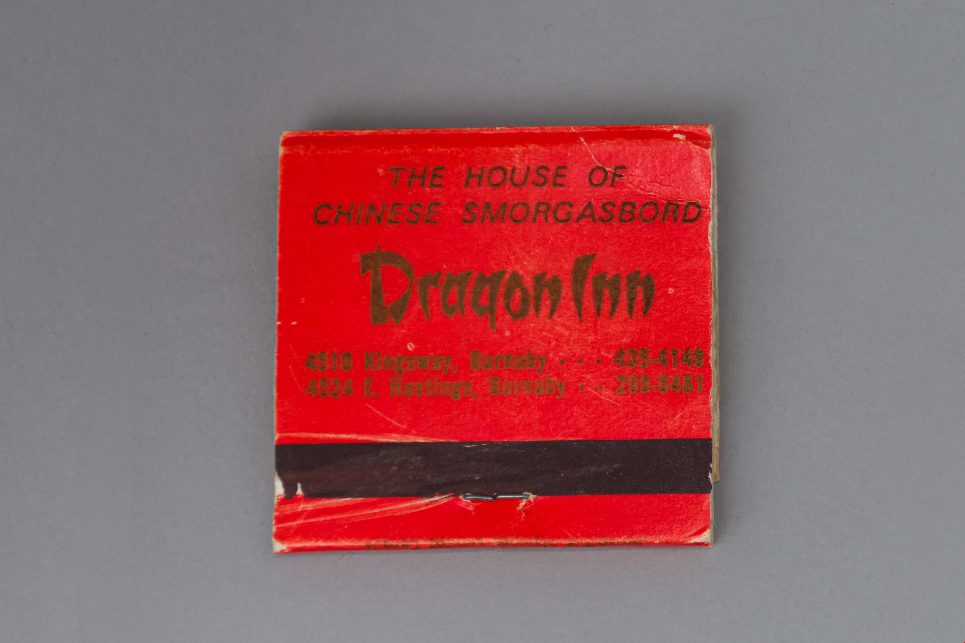
matchbook
https://search.heritageburnaby.ca/link/museumartifact89161
- Repository
- Burnaby Village Museum
- Accession Code
- BV017.37.8
- Description
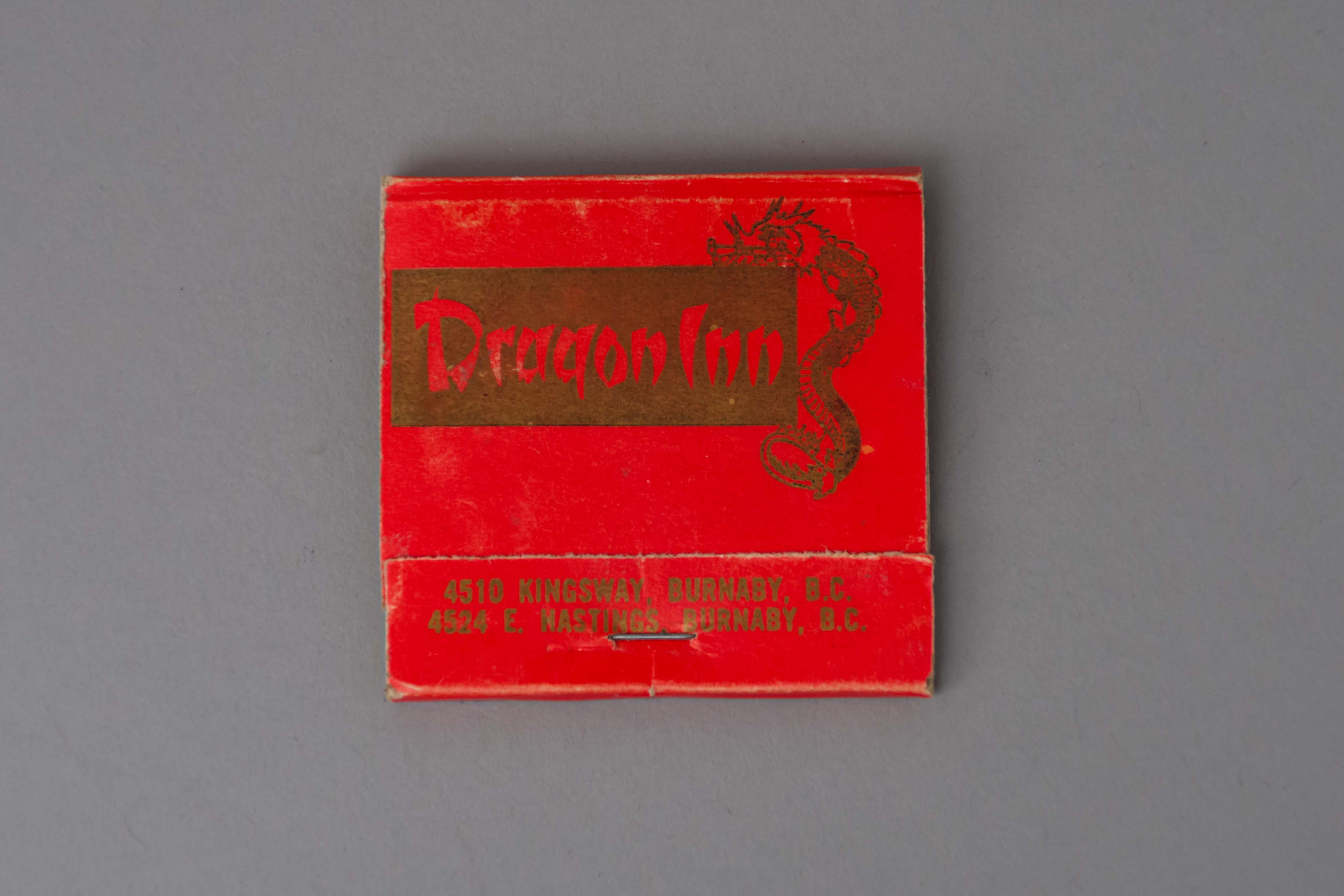
- matchbook; red folded paper with gold ink text and illustration of a dragon; "Dragon Inn / 4510 KINGSWAY, BURNABY, B.C. / 4524 E. HASTINGS, BURNABY B.C." printed on face; "THE HOUSE OF / CHINESE SMORGASBORD / Dragon Inn / 4510 Kingsway, Burnaby . . . 435-4148 / 4524 E. Hastings . . . 298-6481". There are pink-tipped matches in the book.
- Object History
- Dragon Inn belonged to the Lee family. The Dragon Inn restaurant was located at at 4510 Kingsway, on the corner of Kingsway and Willingdon Avenue (opened in the 1970s) and later at Hastings Street near Willingdon (opened in the 1990s). The Dragon Inn was known for its exterior neon sign which was removed in 1997.
- Category
- 02. Furnishings
- Classification
- Temperature Control Equipment - - Firemaking Equipment
- Object Term
- Matchbook
- Names
- Dragon Inn
- Geographic Access
- Kingsway
- Street Address
- 4510 Kingsway
- Historic Neighbourhood
- Central Park (Historic Neighbourhood)
- Planning Study Area
- Maywood Area
Images
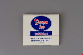
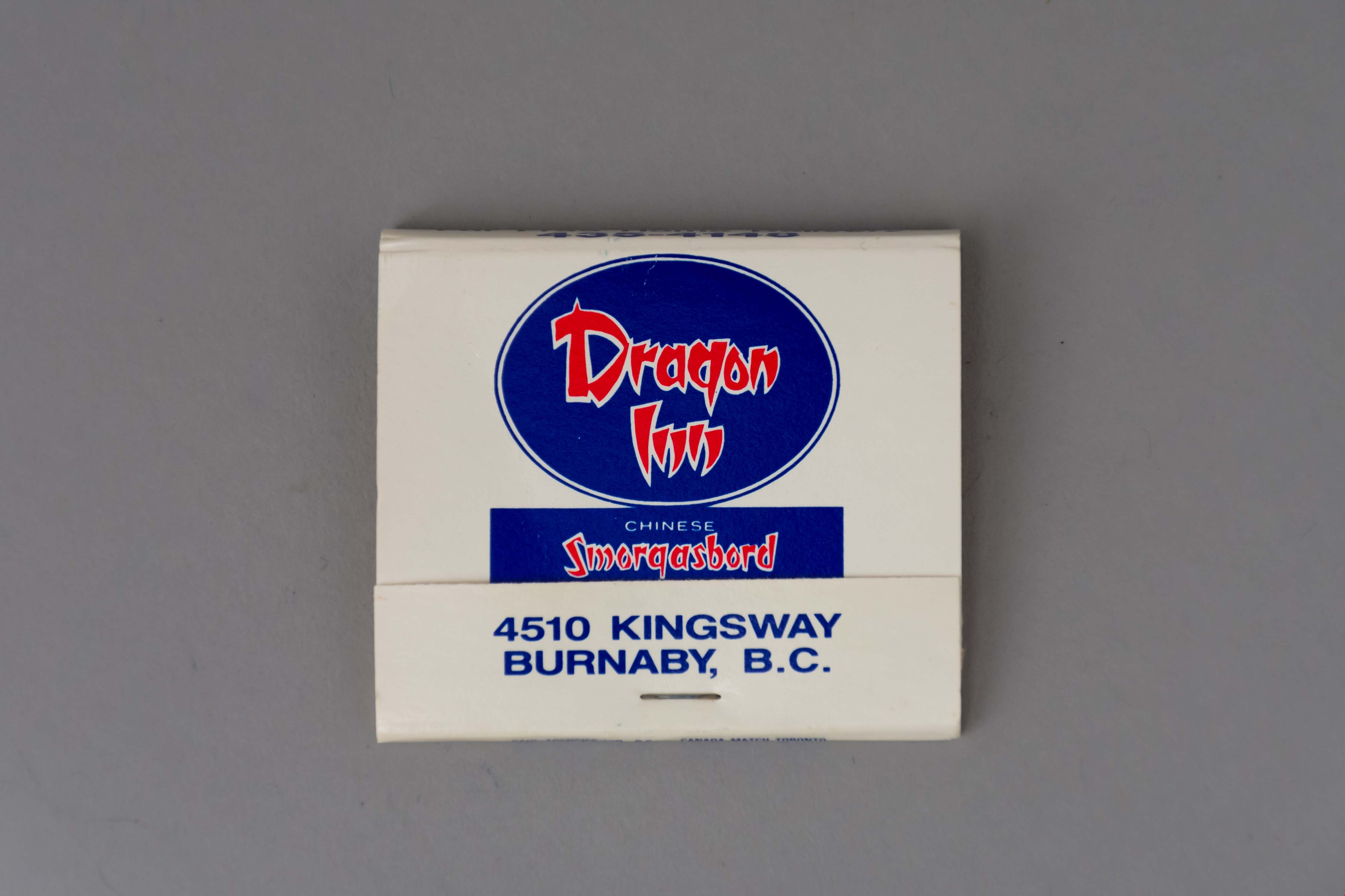
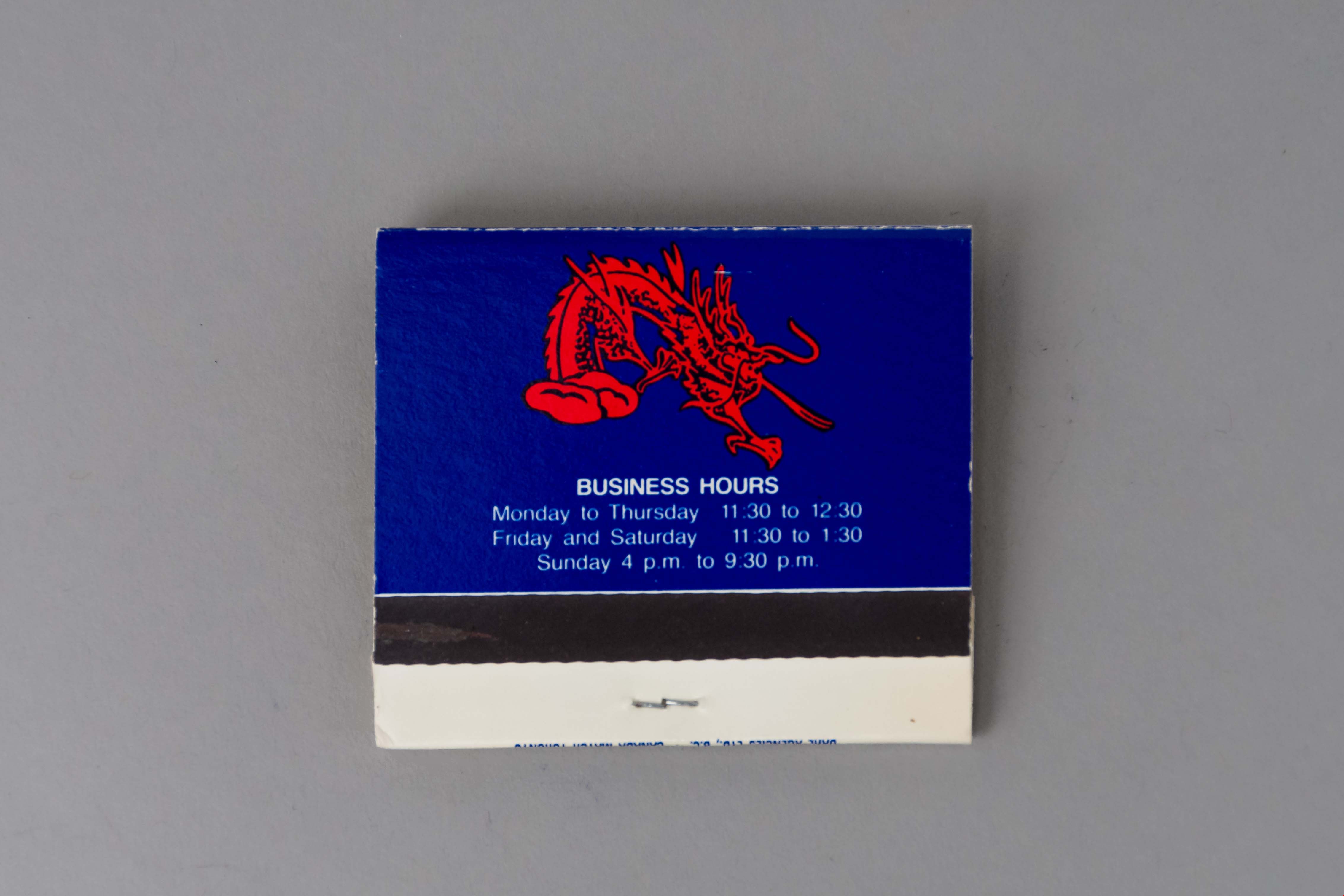
matchbook
https://search.heritageburnaby.ca/link/museumartifact89162
- Repository
- Burnaby Village Museum
- Accession Code
- BV017.37.9
- Description
- matchbook; white folded paper with blue and red ink text and illustration of a dragon; "Dragon / Inn / CHINESE / Smorgasbord / EVERY DAY / 4510 KINGSWAY / BURNABY, B.C." printed on face; business hours printed on back. There are blue-tipped matches in the book; manufactured by "DAHL AGENCIES LTD, B.C. * CANADA MATCH TORONTO".
- Object History
- Dragon Inn belonged to the Lee family. The Dragon Inn restaurant was located at at 4510 Kingsway, on the corner of Kingsway and Willingdon Avenue (opened in the 1970s) and later at Hastings Street near Willingdon (opened in the 1990s). The Dragon Inn was known for its exterior neon sign which was removed in 1997.
- Category
- 02. Furnishings
- Classification
- Temperature Control Equipment - - Firemaking Equipment
- Object Term
- Matchbook
- Names
- Dragon Inn
- Geographic Access
- Kingsway
- Street Address
- 4510 Kingsway
- Historic Neighbourhood
- Central Park (Historic Neighbourhood)
- Planning Study Area
- Maywood Area
Images
![West Burnaby teachers and trophies, [191-] thumbnail](/media/hpo/_Data/_BVM_Images/2012/2012_0020_0004_001.jpg?width=280)
West Burnaby teachers and trophies
https://search.heritageburnaby.ca/link/museumdescription2941
- Repository
- Burnaby Village Museum
- Date
- [191-]
- Collection/Fonds
- Burnaby Village Museum Photograph collection
- Description Level
- Item
- Physical Description
- 1 photograph : b&w ; 8.5 x 11 cm
- Scope and Content
- Photograph of seven teachers standing behind a table with trophies at the entrance to West Burnaby School (Kingway West School). The group is standing at the foot of the front steps to the school, behind a table draped with a Union Jack flag with three trophies on top. Teachers are identified as; …
- Repository
- Burnaby Village Museum
- Collection/Fonds
- Burnaby Village Museum Photograph collection
- Description Level
- Item
- Physical Description
- 1 photograph : b&w ; 8.5 x 11 cm
- Scope and Content
- Photograph of seven teachers standing behind a table with trophies at the entrance to West Burnaby School (Kingway West School). The group is standing at the foot of the front steps to the school, behind a table draped with a Union Jack flag with three trophies on top. Teachers are identified as; Mr. Brown (second from left), Miss Annie Theresa Forrest (third from left), Miss Brice (center), Miss Gray (second from right) and Miss Morrow (far right).
- Subjects
- Occupations - Teachers
- Geographic Access
- Kingsway
- Street Address
- 4800 Kingsway
- Accession Code
- BV012.20.4
- Access Restriction
- No restrictions
- Reproduction Restriction
- No known restrictions
- Date
- [191-]
- Media Type
- Photograph
- Historic Neighbourhood
- Central Park (Historic Neighbourhood)
- Planning Study Area
- Maywood Area
- Scan Resolution
- 600
- Scan Date
- 13-Mar-2018
- Notes
- Title based on contents of photograph
Images
![West Burnaby teachers and trophies, [191-] thumbnail](/media/hpo/_Data/_BVM_Images/2012/2012_0020_0004_001.jpg)
![William Brenchley house, [between 1890 and 1895] (date of original), copied 1985 thumbnail](/media/hpo/_Data/_Archives_Images/_Unrestricted/126/146-001.jpg?width=280)
William Brenchley house
https://search.heritageburnaby.ca/link/archivedescription34863
- Repository
- City of Burnaby Archives
- Date
- [between 1890 and 1895] (date of original), copied 1985
- Collection/Fonds
- Burnaby Historical Society fonds
- Description Level
- Item
- Physical Description
- 1 photograph : b&w ; 8.8 x 12.5 cm print
- Scope and Content
- Photograph of the exterior of the house of William Brenchley at 10th Avenue and Kingsway, northeast corner. A number of people are standing outside. Partially cleared land can be seen in the background.
- Repository
- City of Burnaby Archives
- Date
- [between 1890 and 1895] (date of original), copied 1985
- Collection/Fonds
- Burnaby Historical Society fonds
- Subseries
- W.E. Brenchley subseries
- Physical Description
- 1 photograph : b&w ; 8.8 x 12.5 cm print
- Description Level
- Item
- Record No.
- 146-001
- Access Restriction
- No restrictions
- Reproduction Restriction
- No known restrictions
- Accession Number
- BHS1985-16
- Scope and Content
- Photograph of the exterior of the house of William Brenchley at 10th Avenue and Kingsway, northeast corner. A number of people are standing outside. Partially cleared land can be seen in the background.
- Subjects
- Buildings - Residential - Houses
- Media Type
- Photograph
- Notes
- Title based on contents of photograph
- Geographic Access
- 10th Avenue
- Kingsway
- Historic Neighbourhood
- Edmonds (Historic Neighbourhood)
- Planning Study Area
- Edmonds Area
Images
![William Brenchley house, [between 1890 and 1895] (date of original), copied 1985 thumbnail](/media/hpo/_Data/_Archives_Images/_Unrestricted/126/146-001.jpg)
![William Brenchley farm, [between 1890 and 1895] (date of original), copied 1985 thumbnail](/media/hpo/_Data/_Archives_Images/_Unrestricted/126/146-002.jpg?width=280)
William Brenchley farm
https://search.heritageburnaby.ca/link/archivedescription34864
- Repository
- City of Burnaby Archives
- Date
- [between 1890 and 1895] (date of original), copied 1985
- Collection/Fonds
- Burnaby Historical Society fonds
- Description Level
- Item
- Physical Description
- 1 photograph : b&w ; 8.8 x 12.5 cm print
- Scope and Content
- Photograph of a farm hand and horse team inside a large stump, taken on William Brenchley's farm. The farm was located at the northeast corner of Kingsway and 10th Avenue.
- Repository
- City of Burnaby Archives
- Date
- [between 1890 and 1895] (date of original), copied 1985
- Collection/Fonds
- Burnaby Historical Society fonds
- Subseries
- W.E. Brenchley subseries
- Physical Description
- 1 photograph : b&w ; 8.8 x 12.5 cm print
- Description Level
- Item
- Record No.
- 146-002
- Access Restriction
- No restrictions
- Reproduction Restriction
- No known restrictions
- Accession Number
- BHS1985-16
- Scope and Content
- Photograph of a farm hand and horse team inside a large stump, taken on William Brenchley's farm. The farm was located at the northeast corner of Kingsway and 10th Avenue.
- Media Type
- Photograph
- Photographer
- Thompson, S.J.
- Notes
- Title based on contents of photograph
- Geographic Access
- 10th Avenue
- Kingsway
- Historic Neighbourhood
- Edmonds (Historic Neighbourhood)
- Planning Study Area
- Edmonds Area
Images
![William Brenchley farm, [between 1890 and 1895] (date of original), copied 1985 thumbnail](/media/hpo/_Data/_Archives_Images/_Unrestricted/126/146-002.jpg)

Royal Oak Hotel
https://search.heritageburnaby.ca/link/landmark726
- Repository
- Burnaby Heritage Planning
- Geographic Access
- Kingsway
- Associated Dates
- 1891
- Heritage Value
- One of the most notorious landmarks in Burnaby was the Royal Oak Hotel, constructed around 1891 at the present-day northeast corner of Kingsway and Royal Oak. Levis Morrison built the hotel, then sold out to Charles Cridland, whose poor hotel reputation prompted Burnaby council to hire its second police constable. The hotel continued to operate until 1973 when it was demolished to build a Safeway store.
- Historic Neighbourhood
- Central Park (Historic Neighbourhood)
- Planning Study Area
- Marlborough Area
- Street View URL
- Google Maps Street View
Images


Powerhouse
https://search.heritageburnaby.ca/link/landmark731
- Repository
- Burnaby Heritage Planning
- Geographic Access
- Griffiths Avenue
- Kingsway
- Associated Dates
- 1891
- Heritage Value
- Constructed in 1891 between Edmonds and Highland Park on the Central Park Interurban Line, the steam plant provided power to run the line, then operated by Westminster and Vancouver Tramway Company. The steam powerhouse was replaced in 1905 by a B.C. Electric substation which was put into operation to receive and distribute power from the B.C.E.R. Buntzen Lake power dam. Prior to Burnaby having its own Municipal Hall, Council meetings were often held at the boarding house adjacent to the powerhouse and in 1892, Burnaby’s first Council meeting was held at the boarding house in 1892.
- Historic Neighbourhood
- Edmonds (Historic Neighbourhood)
- Planning Study Area
- Kingsway-Beresford Area
Images


Edison Road Power House
https://search.heritageburnaby.ca/link/archivedescription36086
- Repository
- City of Burnaby Archives
- Date
- 1893 (date of original), copied November 26, 1975
- Collection/Fonds
- Burnaby Historical Society fonds
- Description Level
- Item
- Physical Description
- 1 photograph : b&w ; 10.5 x 14 cm print
- Scope and Content
- Photograph of the Edison Road Power House, of the Westminster and Vancouver Tramway Co. Ltd., the first electric interurban street railway in North America. This power house stood between Vancouver Road (Kingsway) and the line to Vancouver. (Edison Road is now Griffiths Avenue).
- Repository
- City of Burnaby Archives
- Date
- 1893 (date of original), copied November 26, 1975
- Collection/Fonds
- Burnaby Historical Society fonds
- Subseries
- Columbian Newspaper subseries
- Physical Description
- 1 photograph : b&w ; 10.5 x 14 cm print
- Description Level
- Item
- Record No.
- 222-009
- Access Restriction
- No restrictions
- Reproduction Restriction
- No known restrictions
- Accession Number
- BHS1989-19
- Scope and Content
- Photograph of the Edison Road Power House, of the Westminster and Vancouver Tramway Co. Ltd., the first electric interurban street railway in North America. This power house stood between Vancouver Road (Kingsway) and the line to Vancouver. (Edison Road is now Griffiths Avenue).
- Media Type
- Photograph
- Notes
- Title based on contents of photograph
- Geographic Access
- Griffiths Avenue
- Kingsway
- Historic Neighbourhood
- Edmonds (Historic Neighbourhood)
- Planning Study Area
- Kingsway-Beresford Area
Images

![Gilley Brothers Logging team, [1895] thumbnail](/media/hpo/_Data/_Archives_Images/_Unrestricted/371/461-003.jpg?width=280)
Gilley Brothers Logging team
https://search.heritageburnaby.ca/link/archivedescription38561
- Repository
- City of Burnaby Archives
- Date
- [1895]
- Collection/Fonds
- Burnaby Historical Society fonds
- Description Level
- Item
- Physical Description
- 1 photograph : b&w ; 28 x 35.2 cm
- Scope and Content
- Photograph of a team of horses crossing a plank bridge with cleared trees and forest in the background.
- Repository
- City of Burnaby Archives
- Date
- [1895]
- Collection/Fonds
- Burnaby Historical Society fonds
- Subseries
- Photographs subseries
- Physical Description
- 1 photograph : b&w ; 28 x 35.2 cm
- Description Level
- Item
- Record No.
- 461-003
- Access Restriction
- No restrictions
- Reproduction Restriction
- No known restrictions
- Accession Number
- BHS2007-04
- Scope and Content
- Photograph of a team of horses crossing a plank bridge with cleared trees and forest in the background.
- Media Type
- Photograph
- Notes
- Title based on contents of photograph
- A note on the back of item no. 379-001 (the copy print to this original reads: "Logging operation at Kingsway and Gilley Avenue carried on by Gilley Brothers before the turn of the century."
- Geographic Access
- Kingsway
- Gilley Avenue
- Historic Neighbourhood
- Edmonds (Historic Neighbourhood)
- Planning Study Area
- Kingsway-Beresford Area
Images
![Gilley Brothers Logging team, [1895] thumbnail](/media/hpo/_Data/_Archives_Images/_Unrestricted/371/461-003.jpg)

Central Park Presbyterian Church
https://search.heritageburnaby.ca/link/archivedescription36673
- Repository
- City of Burnaby Archives
- Date
- 1896 (date of original), copied 1992
- Collection/Fonds
- Burnaby Historical Society fonds
- Description Level
- Item
- Physical Description
- 1 photograph : b&w ; 10.1 x 14.9 cm print
- Scope and Content
- Photograph of the exterior of Central Park Presbyterian Church. Typed note at the bottom of the photograph reads, "The Original Presbyterian Church on Westminster Road at Central Park as in approx. 1896. Burned down and rebuilt. Mrs. P. Oben."
- Repository
- City of Burnaby Archives
- Date
- 1896 (date of original), copied 1992
- Collection/Fonds
- Burnaby Historical Society fonds
- Subseries
- Burnaby Centennial Anthology subseries
- Physical Description
- 1 photograph : b&w ; 10.1 x 14.9 cm print
- Description Level
- Item
- Record No.
- 315-028
- Access Restriction
- No restrictions
- Reproduction Restriction
- No known restrictions
- Accession Number
- BHS1994-04
- Scope and Content
- Photograph of the exterior of Central Park Presbyterian Church. Typed note at the bottom of the photograph reads, "The Original Presbyterian Church on Westminster Road at Central Park as in approx. 1896. Burned down and rebuilt. Mrs. P. Oben."
- Subjects
- Buildings - Religious - Churches
- Media Type
- Photograph
- Notes
- Title based on contents of photograph
- Geographic Access
- Westminster Avenue
- Kingsway
- Street Address
- 3777 Kingsway
- Historic Neighbourhood
- Central Park (Historic Neighbourhood)
- Planning Study Area
- Garden Village Area
Images


West Burnaby School (aka Kingsway West School)
https://search.heritageburnaby.ca/link/landmark727
- Repository
- Burnaby Heritage Planning
- Geographic Access
- Kingsway
- Associated Dates
- 1896
- Heritage Value
- West Burnaby School was to be Burnaby's second public school and it served the children who lived along the tram line and Vancouver Road (Kingsway).
- Historic Neighbourhood
- Central Park (Historic Neighbourhood)
- Planning Study Area
- Maywood Area
- Street View URL
- Google Maps Street View
Images

West Burnaby School class
https://search.heritageburnaby.ca/link/archivedescription36019
- Repository
- City of Burnaby Archives
- Date
- 1898
- Collection/Fonds
- Burnaby Historical Society fonds
- Description Level
- Item
- Physical Description
- 1 photograph : sepia ; 19.5 x 24 cm, mounted on board 25 x 30 cm
- Scope and Content
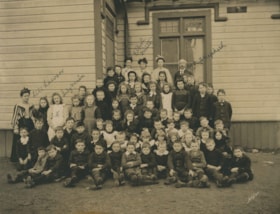
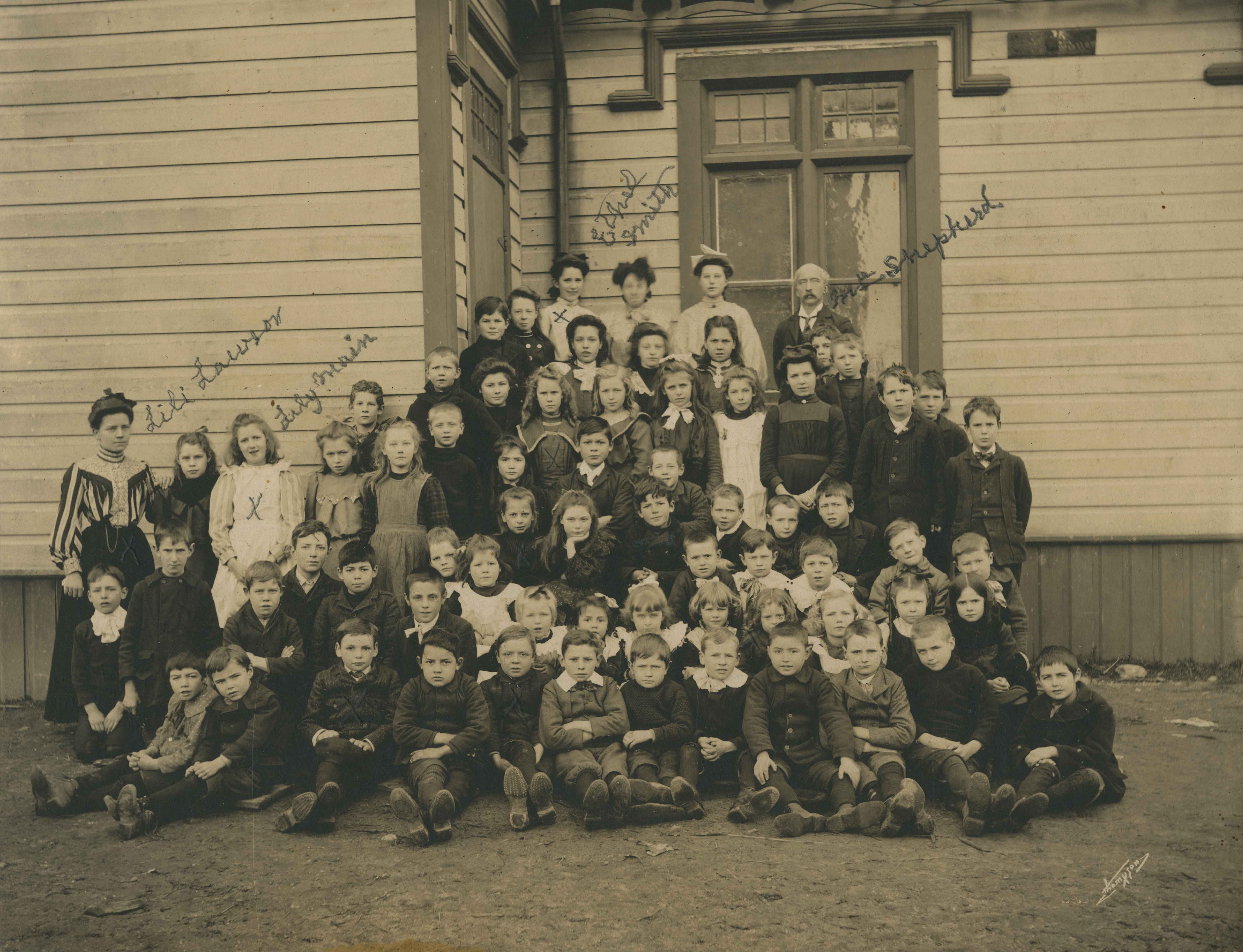
- Photograph of the West Burnaby School class, including teachers, lined up in rows on the porch steps, with the first row seated on the ground with their feet crossed in front of them. Individuals that have been identified, in pencil, directly on the photograph include; Teacher Lili Lawson (far left…
- Repository
- City of Burnaby Archives
- Date
- 1898
- Collection/Fonds
- Burnaby Historical Society fonds
- Subseries
- Patterson family subseries
- Physical Description
- 1 photograph : sepia ; 19.5 x 24 cm, mounted on board 25 x 30 cm
- Description Level
- Item
- Record No.
- 213-001
- Access Restriction
- No restrictions
- Reproduction Restriction
- No known restrictions
- Accession Number
- BHS1988-13
- Scope and Content
- Photograph of the West Burnaby School class, including teachers, lined up in rows on the porch steps, with the first row seated on the ground with their feet crossed in front of them. Individuals that have been identified, in pencil, directly on the photograph include; Teacher Lili Lawson (far left), Lily Main (two over from Lawson), Ethel Smith (far left in the back row), and Headmaster Samuel Shepard (far right in the back row). Members of the Patterson family are also in this photograph; William (Bill) is sitting in the front row, third from the left, Bruce is sitting two to the right of Bill, with Alice two rows directly behind Bruce (her hair is shorter than the other girls and she is wearing a dark shirt), with their older sister Mary standing two rows directly behind Alice. The school was later renamed Kingsway West School and remained in operations until 1952.
- Subjects
- Occupations - Teachers
- Media Type
- Photograph
- Notes
- Title based on contents of photograph
- Photographer identified as "Thompson"
- Geographic Access
- Kingsway
- Street Address
- 4800 Kingsway
- Historic Neighbourhood
- Central Park (Historic Neighbourhood)
- Planning Study Area
- Maywood Area
Images
![West Burnaby School, [1898] thumbnail](/media/hpo/_Data/_Archives_Images/_Unrestricted/251/297-001.jpg?width=280)
West Burnaby School
https://search.heritageburnaby.ca/link/archivedescription36571
- Repository
- City of Burnaby Archives
- Date
- [1898]
- Collection/Fonds
- Burnaby Historical Society fonds
- Description Level
- Item
- Physical Description
- 1 photograph : sepia ; 18.5 x 23.5 cm, mounted on board 21.5 x 25 cm + 1p. accompanying
- Scope and Content
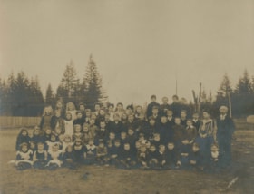
- Photograph of West Burnaby School students standing outside in front of their school in two long rows, with their teacher and school staff members standing on the right. Daisy Birchell is the smallest in the group, standing in the front row, eighth from the left, and her cousin is standing beside h…
- Repository
- City of Burnaby Archives
- Date
- [1898]
- Collection/Fonds
- Burnaby Historical Society fonds
- Subseries
- Photographs subseries
- Physical Description
- 1 photograph : sepia ; 18.5 x 23.5 cm, mounted on board 21.5 x 25 cm + 1p. accompanying
- Description Level
- Item
- Record No.
- 297-001
- Access Restriction
- No restrictions
- Reproduction Restriction
- No known restrictions
- Accession Number
- BHS1992-37
- Scope and Content
- Photograph of West Burnaby School students standing outside in front of their school in two long rows, with their teacher and school staff members standing on the right. Daisy Birchell is the smallest in the group, standing in the front row, eighth from the left, and her cousin is standing beside her, ninth from the left. The school was later renamed Kingsway West School and remained in operations until 1952.
- Subjects
- Buildings - Schools
- Media Type
- Photograph
- Notes
- Title based on contents of photograph
- Note in accompanying material states that the photograph is the property of Charles Burchell's family, and "children as pupils" were; William, Frederick, Lily, and Daisy Burchell.
- Geographic Access
- Kingsway
- Street Address
- 4800 Kingsway
- Historic Neighbourhood
- Central Park (Historic Neighbourhood)
- Planning Study Area
- Maywood Area
Images
![West Burnaby School, [1898] thumbnail](/media/hpo/_Data/_Archives_Images/_Unrestricted/251/297-001.jpg)
West Burnaby School class outside
https://search.heritageburnaby.ca/link/archivedescription37334
- Repository
- City of Burnaby Archives
- Date
- 1898
- Collection/Fonds
- Burnaby Historical Society fonds
- Description Level
- Item
- Physical Description
- 1 photograph : sepia ; 20.5 x 25.3 cm on 30.5 x 37.5 cm mat
- Scope and Content
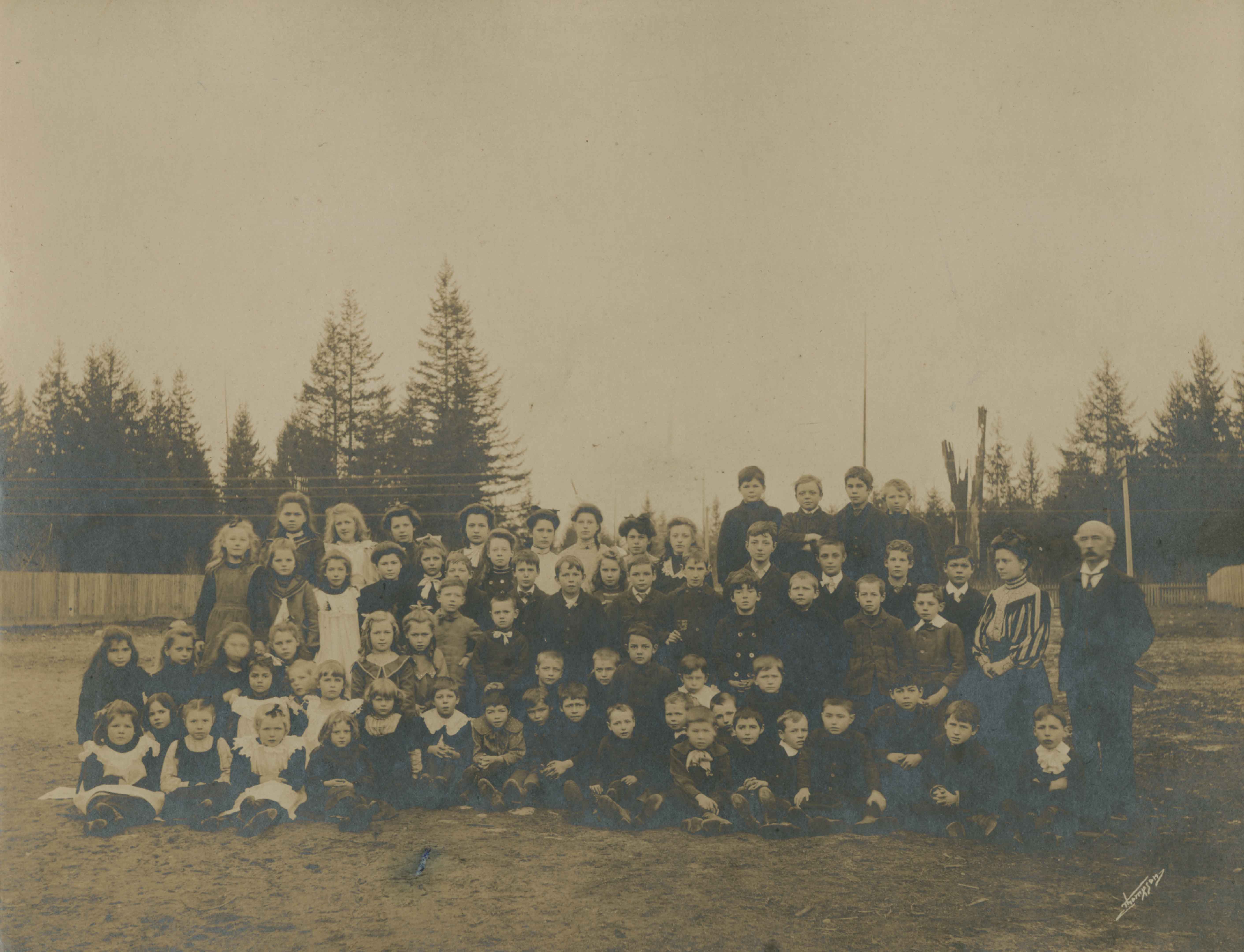
- Photograph of the West Burnaby School class, including teachers, on the dirt field next to the school. Eight of the individuals have been identified; sitting in the second row, second from the left is (8) Alice Patterson, standing in the center of the third row is (4) William (Bill) Pattterson, and…
- Repository
- City of Burnaby Archives
- Date
- 1898
- Collection/Fonds
- Burnaby Historical Society fonds
- Subseries
- Millway family subseries
- Physical Description
- 1 photograph : sepia ; 20.5 x 25.3 cm on 30.5 x 37.5 cm mat
- Description Level
- Item
- Record No.
- 353-001
- Access Restriction
- No restrictions
- Reproduction Restriction
- No known restrictions
- Accession Number
- BHS1997-12
- Scope and Content
- Photograph of the West Burnaby School class, including teachers, on the dirt field next to the school. Eight of the individuals have been identified; sitting in the second row, second from the left is (8) Alice Patterson, standing in the center of the third row is (4) William (Bill) Pattterson, and in the back row on the far left is (7) Mary Patterson, beside her, (6) Lily Main, three from Lily is (5)Ethel Smith, and third from the right in the same row is (3) Bruce Patterson. The school headmaster (1) Samuel Shepard is standing on the far right and standing next to him is their teacher, (2) Lily Smith. The school was later renamed Kingsway West School and remained in operations until 1952.
- Subjects
- Occupations - Teachers
- Names
- Kingsway West School
- Media Type
- Photograph
- Notes
- Title based on contents of photograph
- Photographer identified as "Thompson"
- Geographic Access
- Kingsway
- Street Address
- 4800 Kingsway
- Historic Neighbourhood
- Central Park (Historic Neighbourhood)
- Planning Study Area
- Maywood Area
Images
![Burnaby's first Municipal Hall, [between 1899 and 1911] (date of original), copied 1995 thumbnail](/media/hpo/_Data/_Archives_Images/_Unrestricted/316/316-006.jpg?width=280)
Burnaby's first Municipal Hall
https://search.heritageburnaby.ca/link/archivedescription37100
- Repository
- City of Burnaby Archives
- Date
- [between 1899 and 1911] (date of original), copied 1995
- Collection/Fonds
- Burnaby Historical Society fonds
- Description Level
- Item
- Physical Description
- 1 photograph : b&w ; 10 x 15 cm print
- Scope and Content
- Photograph of council members and others sitting and standing on the steps of Burnaby's first Municipal Hall.
- Repository
- City of Burnaby Archives
- Date
- [between 1899 and 1911] (date of original), copied 1995
- Collection/Fonds
- Burnaby Historical Society fonds
- Subseries
- Byrne family subseries
- Physical Description
- 1 photograph : b&w ; 10 x 15 cm print
- Description Level
- Item
- Record No.
- 316-006
- Access Restriction
- No restrictions
- Reproduction Restriction
- No known restrictions
- Accession Number
- BHS1995-04
- Scope and Content
- Photograph of council members and others sitting and standing on the steps of Burnaby's first Municipal Hall.
- Names
- Burnaby City Hall
- Media Type
- Photograph
- Notes
- Title based on contents of photograph
- Geographic Access
- Kingsway
- Street Address
- 7252 Kingsway
- Historic Neighbourhood
- Edmonds (Historic Neighbourhood)
- Planning Study Area
- Stride Avenue Area
Images
![Burnaby's first Municipal Hall, [between 1899 and 1911] (date of original), copied 1995 thumbnail](/media/hpo/_Data/_Archives_Images/_Unrestricted/316/316-006.jpg)
Burnaby Municipal Hall
https://search.heritageburnaby.ca/link/landmark730
- Repository
- Burnaby Heritage Planning
- Geographic Access
- Kingsway
- Associated Dates
- 1899
- Heritage Value
- Although Burnaby was incorporated as a municipality in 1892, its first Municipal Hall was not built until 1899 and located at Kingsway and Edmonds. It was close to the tram line on Kingsway and at the population centre of South Burnaby.
- Historic Neighbourhood
- Edmonds (Historic Neighbourhood)
- Planning Study Area
- Stride Avenue Area
- Street Address
- 7252 Kingsway
- Street View URL
- Google Maps Street View
Images