Narrow Results By
Subject
- Accidents 1
- Accidents - Automobile Accidents 1
- Advertising Medium 3
- Advertising Medium - Signs and Signboards
- Aerial Photographs
- Agricultural Tools and Equipment - Gardening Equipment 1
- Agricultural Tools and Equipment - Plows
- Agriculture - Crops 4
- Agriculture - Farms 11
- Agriculture - Fruit and Berries 4
- Agriculture - Orchards 1
- Agriculture - Poultry 3

Heyworth family
https://search.heritageburnaby.ca/link/archivedescription35072
- Repository
- City of Burnaby Archives
- Date
- 1939 (date of original), copied 1986
- Collection/Fonds
- Burnaby Historical Society fonds
- Description Level
- Item
- Physical Description
- 1 photograph : b&w negative ; 9.0 x 6.0 cm
- Scope and Content
- Photograph of Mr. and Mrs. [G.R.] Heyworth and "Aunt Betty" outside standing outside Jubilee Drug Store, Jubilee Avenue and Imperial Street (later the location of Bonsor Park, 6550 Bonsor Avenue). An electric sign reads, "Rexall Drugs." A dog can be seen at the bottom of the photograph. An accom…
- Repository
- City of Burnaby Archives
- Date
- 1939 (date of original), copied 1986
- Collection/Fonds
- Burnaby Historical Society fonds
- Subseries
- Heyworth family subseries
- Physical Description
- 1 photograph : b&w negative ; 9.0 x 6.0 cm
- Description Level
- Item
- Record No.
- 187-005
- Access Restriction
- No restrictions
- Reproduction Restriction
- No known restrictions
- Accession Number
- BHS1986-38
- Scope and Content
- Photograph of Mr. and Mrs. [G.R.] Heyworth and "Aunt Betty" outside standing outside Jubilee Drug Store, Jubilee Avenue and Imperial Street (later the location of Bonsor Park, 6550 Bonsor Avenue). An electric sign reads, "Rexall Drugs." A dog can be seen at the bottom of the photograph. An accompanying letter describes the photo as "Dad with Mother and Aunt Betty. They had just walked back from Kingsway after seeing the King and Queen pass - 1937 [sic; the royal visit was in 1939]."
- Subjects
- Animals - Dogs
- Buildings - Commercial - Drugstores
- Advertising Medium - Signs and Signboards
- Media Type
- Photograph
- Notes
- Title based on contents of photograph
- 1 b&w copy print accompanying
- Geographic Access
- Jubilee Avenue
- Bonsor Avenue
- Street Address
- 6550 Bonsor Avenue
- Historic Neighbourhood
- Central Park (Historic Neighbourhood)
- Planning Study Area
- Marlborough Area
Images

![Hickman Family Store, [1940] (date of original), copied 1986 thumbnail](/media/hpo/_Data/_Archives_Images/_Unrestricted/204/204-243.jpg?width=280)
Hickman Family Store
https://search.heritageburnaby.ca/link/archivedescription35386
- Repository
- City of Burnaby Archives
- Date
- [1940] (date of original), copied 1986
- Collection/Fonds
- Burnaby Historical Society fonds
- Description Level
- Item
- Physical Description
- 1 photograph : b&w ; 12.7 x 17.8 cm print
- Scope and Content
- Photograph of the exterior of Hickmans Market. This store was owned and operated by Alf Hickman and was located on Patterson Avenue (later numbered 5932 Patterson Avenue).
- Repository
- City of Burnaby Archives
- Date
- [1940] (date of original), copied 1986
- Collection/Fonds
- Burnaby Historical Society fonds
- Subseries
- Pioneer Tales subseries
- Physical Description
- 1 photograph : b&w ; 12.7 x 17.8 cm print
- Description Level
- Item
- Record No.
- 204-243
- Access Restriction
- No restrictions
- Reproduction Restriction
- No known restrictions
- Accession Number
- BHS1988-03
- Scope and Content
- Photograph of the exterior of Hickmans Market. This store was owned and operated by Alf Hickman and was located on Patterson Avenue (later numbered 5932 Patterson Avenue).
- Names
- Hickman and Son Market
- Media Type
- Photograph
- Notes
- Title based on contents of photograph
- Geographic Access
- Patterson Avenue
- Street Address
- 5932 Patterson Avenue
- Historic Neighbourhood
- Central Park (Historic Neighbourhood)
- Planning Study Area
- Maywood Area
Images
![Hickman Family Store, [1940] (date of original), copied 1986 thumbnail](/media/hpo/_Data/_Archives_Images/_Unrestricted/204/204-243.jpg)
![Jubilee Avenue, [192-] (date of original), copied 1986 thumbnail](/media/hpo/_Data/_Archives_Images/_Unrestricted/126/187-002.jpg?width=280)
Jubilee Avenue
https://search.heritageburnaby.ca/link/archivedescription35069
- Repository
- City of Burnaby Archives
- Date
- [192-] (date of original), copied 1986
- Collection/Fonds
- Burnaby Historical Society fonds
- Description Level
- Item
- Physical Description
- 1 photograph : b&w ; 11.4 x 7.1 cm
- Scope and Content
- Photograph of stores on Jubilee Avenue looking north from Imperial Street (later the location of Bonsor Park, 6550 Bonsor Avenue). Signs visible read; "Jubilee Drug Store," "Drugs," "Jubilee [Mercantile?] Co. / Groceries," "Nabob Tea," and "[Carvers or Corvers]." An accompanying description in the…
- Repository
- City of Burnaby Archives
- Date
- [192-] (date of original), copied 1986
- Collection/Fonds
- Burnaby Historical Society fonds
- Subseries
- Heyworth family subseries
- Physical Description
- 1 photograph : b&w ; 11.4 x 7.1 cm
- Description Level
- Item
- Record No.
- 187-002
- Access Restriction
- No restrictions
- Reproduction Restriction
- No known restrictions
- Accession Number
- BHS1986-38
- Scope and Content
- Photograph of stores on Jubilee Avenue looking north from Imperial Street (later the location of Bonsor Park, 6550 Bonsor Avenue). Signs visible read; "Jubilee Drug Store," "Drugs," "Jubilee [Mercantile?] Co. / Groceries," "Nabob Tea," and "[Carvers or Corvers]." An accompanying description in the accession file states that a man named Pat Flannagan ran the grocery.
- Media Type
- Photograph
- Notes
- Title based on contents of photograph
- Stamp on verso of photograph reads: "5272"
- Geographic Access
- Jubilee Avenue
- Bonsor Avenue
- Street Address
- 6550 Bonsor Avenue
- Historic Neighbourhood
- Central Park (Historic Neighbourhood)
- Planning Study Area
- Marlborough Area
Images
![Jubilee Avenue, [192-] (date of original), copied 1986 thumbnail](/media/hpo/_Data/_Archives_Images/_Unrestricted/126/187-002.jpg)
![Jubilee Drug Store, [1918] thumbnail](/media/hpo/_Data/_Archives_Images/_Unrestricted/126/187-001.jpg?width=280)
Jubilee Drug Store
https://search.heritageburnaby.ca/link/archivedescription35068
- Repository
- City of Burnaby Archives
- Date
- [1918]
- Collection/Fonds
- Burnaby Historical Society fonds
- Description Level
- Item
- Physical Description
- 1 photograph : b&w ; 8.8 x 12.6 cm print
- Scope and Content
- Photograph of the exterior of Jubilee Drug Store, Jubilee Avenue and Imperial Street (later the location of Bonsor Park, 6550 Bonsor Avenue). Signs on the front of the store read, "Jubilee Drug Store / Drugs / Prescriptions / Lending Library / The Rexall Store." Signs on the side of the building …
- Repository
- City of Burnaby Archives
- Date
- [1918]
- Collection/Fonds
- Burnaby Historical Society fonds
- Subseries
- Heyworth family subseries
- Physical Description
- 1 photograph : b&w ; 8.8 x 12.6 cm print
- Description Level
- Item
- Record No.
- 187-001
- Access Restriction
- No restrictions
- Reproduction Restriction
- No known restrictions
- Accession Number
- BHS1986-38
- Scope and Content
- Photograph of the exterior of Jubilee Drug Store, Jubilee Avenue and Imperial Street (later the location of Bonsor Park, 6550 Bonsor Avenue). Signs on the front of the store read, "Jubilee Drug Store / Drugs / Prescriptions / Lending Library / The Rexall Store." Signs on the side of the building read, "Jubilee Drug Store / Films / Magazines / Violin Strings / Sargon / Puretest Drugs / Rexall Drug Store / NYAL Service Drugstore / Lending Library." A man is standing outside the store (this may be Mr. G.R. Heyworth).
- Names
- Jubilee Drug Store
- Media Type
- Photograph
- Notes
- Title based on contents of photograph
- Geographic Access
- Jubilee Avenue
- Bonsor Avenue
- Street Address
- 6550 Bonsor Avenue
- Historic Neighbourhood
- Central Park (Historic Neighbourhood)
- Planning Study Area
- Marlborough Area
Images
![Jubilee Drug Store, [1918] thumbnail](/media/hpo/_Data/_Archives_Images/_Unrestricted/126/187-001.jpg)

Kingsway
https://search.heritageburnaby.ca/link/archivedescription79943
- Repository
- City of Burnaby Archives
- Date
- September 15, 1976
- Collection/Fonds
- Burnaby Public Library Contemporary Visual Archive Project
- Description Level
- Item
- Physical Description
- 1 photograph : b&w ; 11 x 16 cm mounted on cardboard
- Scope and Content
- Photograph shows a view of Kingsway looking southeast from the 21st floor of the Panorama Towers in Grange Street. The Esso Car Clinic is in the centre of the photo.
- Repository
- City of Burnaby Archives
- Date
- September 15, 1976
- Collection/Fonds
- Burnaby Public Library Contemporary Visual Archive Project
- Physical Description
- 1 photograph : b&w ; 11 x 16 cm mounted on cardboard
- Description Level
- Item
- Record No.
- 556-514
- Access Restriction
- No restrictions
- Reproduction Restriction
- Reproduce for fair dealing purposes only
- Accession Number
- 2013-13
- Scope and Content
- Photograph shows a view of Kingsway looking southeast from the 21st floor of the Panorama Towers in Grange Street. The Esso Car Clinic is in the centre of the photo.
- Subjects
- Aerial Photographs
- Media Type
- Photograph
- Photographer
- McCarron, John
- Notes
- Scope note taken directly from BPL photograph description.
- 1 b&w copy negative : 10 x 12.5 cm accompanying
- Geographic Access
- Kingsway
- Historic Neighbourhood
- Central Park (Historic Neighbourhood)
- Planning Study Area
- Maywood Area
Images


Kingsway
https://search.heritageburnaby.ca/link/archivedescription34510
- Repository
- City of Burnaby Archives
- Date
- 1920
- Collection/Fonds
- Burnaby Historical Society fonds
- Description Level
- Item
- Physical Description
- 1 photograph : sepia ; 12.6 x 17.7 cm
- Scope and Content
- Photograph of Kingsway looking east at Boundary Road. A sign on the right reads, "Burnaby / Vehicles must slow down at all schools and intersections marked thus: X." A sign on a building at the left reads, "Arctic Ice Cream." Central Park is on the right.
- Repository
- City of Burnaby Archives
- Date
- 1920
- Collection/Fonds
- Burnaby Historical Society fonds
- Subseries
- Photographs subseries
- Physical Description
- 1 photograph : sepia ; 12.6 x 17.7 cm
- Description Level
- Item
- Record No.
- 031-001
- Access Restriction
- No restrictions
- Reproduction Restriction
- No known restrictions
- Accession Number
- BHS2007-04
- Scope and Content
- Photograph of Kingsway looking east at Boundary Road. A sign on the right reads, "Burnaby / Vehicles must slow down at all schools and intersections marked thus: X." A sign on a building at the left reads, "Arctic Ice Cream." Central Park is on the right.
- Media Type
- Photograph
- Notes
- Title based on contents of photograph
- Geographic Access
- Kingsway
- Central Park
- Boundary Road
- Historic Neighbourhood
- Central Park (Historic Neighbourhood)
- Planning Study Area
- Garden Village Area
- Maywood Area
Images


Kingsway
https://search.heritageburnaby.ca/link/archivedescription34511
- Repository
- City of Burnaby Archives
- Date
- 1920
- Collection/Fonds
- Burnaby Historical Society fonds
- Description Level
- Item
- Physical Description
- 1 photograph : sepia ; 12.6 x 17.6 cm
- Scope and Content
- Photograph of Kingsway looking east at Boundary Road. A sign on the right reads, "Burnaby / Vehicles must slow down at all schools and intersections marked thus: X." A sign on a building at the left reads, "Arctic Ice Cream." Central Park is on the right.
- Repository
- City of Burnaby Archives
- Date
- 1920
- Collection/Fonds
- Burnaby Historical Society fonds
- Subseries
- Photographs subseries
- Physical Description
- 1 photograph : sepia ; 12.6 x 17.6 cm
- Description Level
- Item
- Record No.
- 031-002
- Access Restriction
- No restrictions
- Reproduction Restriction
- No known restrictions
- Accession Number
- BHS2007-04
- Scope and Content
- Photograph of Kingsway looking east at Boundary Road. A sign on the right reads, "Burnaby / Vehicles must slow down at all schools and intersections marked thus: X." A sign on a building at the left reads, "Arctic Ice Cream." Central Park is on the right.
- Subjects
- Geographic Features - Roads
- Advertising Medium - Signs and Signboards
- Transportation - Automobiles
- Media Type
- Photograph
- Notes
- Title based on contents of photograph
- Geographic Access
- Kingsway
- Central Park
- Boundary Road
- Historic Neighbourhood
- Central Park (Historic Neighbourhood)
- Planning Study Area
- Garden Village Area
- Maywood Area
Images


Kingsway and Central Park
https://search.heritageburnaby.ca/link/archivedescription79964
- Repository
- City of Burnaby Archives
- Date
- October 27, 1976
- Collection/Fonds
- Burnaby Public Library Contemporary Visual Archive Project
- Description Level
- Item
- Physical Description
- 1 photograph : b&w ; 11 x 16 cm mounted on cardboard
- Scope and Content
- Photograph shows a view of Kingsway looking west from Central Park Place.
- Repository
- City of Burnaby Archives
- Date
- October 27, 1976
- Collection/Fonds
- Burnaby Public Library Contemporary Visual Archive Project
- Physical Description
- 1 photograph : b&w ; 11 x 16 cm mounted on cardboard
- Description Level
- Item
- Record No.
- 556-527
- Access Restriction
- No restrictions
- Reproduction Restriction
- Reproduce for fair dealing purposes only
- Accession Number
- 2013-13
- Scope and Content
- Photograph shows a view of Kingsway looking west from Central Park Place.
- Subjects
- Aerial Photographs
- Media Type
- Photograph
- Photographer
- Norton, Paul
- Notes
- Scope note taken directly from BPL photograph description.
- 1 b&w copy negative : 10 x 12.5 cm accompanying
- Geographic Access
- Kingsway
- Historic Neighbourhood
- Central Park (Historic Neighbourhood)
- Planning Study Area
- Maywood Area
Images

![Kingsway and Central Park, [196-] thumbnail](/media/hpo/_Data/_Archives_Images/_Unrestricted/001/083-001.jpg?width=280)
Kingsway and Central Park
https://search.heritageburnaby.ca/link/archivedescription34658
- Repository
- City of Burnaby Archives
- Date
- [196-]
- Collection/Fonds
- Burnaby Historical Society fonds
- Description Level
- Item
- Physical Description
- 1 photograph : b&w ; 14.5 x 19.4 cm
- Scope and Content
- Aerial photograph of Kingsway and Central Park.
- Repository
- City of Burnaby Archives
- Date
- [196-]
- Collection/Fonds
- Burnaby Historical Society fonds
- Subseries
- Photographs subseries
- Physical Description
- 1 photograph : b&w ; 14.5 x 19.4 cm
- Description Level
- Item
- Record No.
- 083-001
- Access Restriction
- No restrictions
- Reproduction Restriction
- Reproduce for fair dealing purposes only
- Accession Number
- BHS2007-04
- Scope and Content
- Aerial photograph of Kingsway and Central Park.
- Media Type
- Photograph
- Notes
- Title based on contents of photograph
- Geographic Access
- Kingsway
- Central Park
- Historic Neighbourhood
- Central Park (Historic Neighbourhood)
- Planning Study Area
- Maywood Area
Images
![Kingsway and Central Park, [196-] thumbnail](/media/hpo/_Data/_Archives_Images/_Unrestricted/001/083-001.jpg)

Martello Group sign at 6615 Telford Avenue
https://search.heritageburnaby.ca/link/archivedescription98675
- Repository
- City of Burnaby Archives
- Date
- 2022
- Collection/Fonds
- Disappearing Burnaby collection
- Description Level
- Item
- Physical Description
- 1 photograph (jpeg) : col.
- Scope and Content
- Photograph of a sign, which reads "Professionally Managed by Martello," on the lawn of an apartment building located at 6615 Telford Avenue. The building was constructed in 1964. Other residential towers, a construction crane, and cars parked along Telford Avenue are visible in the background.
- Repository
- City of Burnaby Archives
- Date
- 2022
- Collection/Fonds
- Disappearing Burnaby collection
- Physical Description
- 1 photograph (jpeg) : col.
- Description Level
- Item
- Record No.
- 634-022
- Access Restriction
- No restrictions
- Reproduction Restriction
- No restrictions
- Accession Number
- 2022-14
- Scope and Content
- Photograph of a sign, which reads "Professionally Managed by Martello," on the lawn of an apartment building located at 6615 Telford Avenue. The building was constructed in 1964. Other residential towers, a construction crane, and cars parked along Telford Avenue are visible in the background.
- Subjects
- Buildings - Residential
- Buildings - Residential - Apartments
- Advertising Medium - Signs and Signboards
- Media Type
- Photograph
- Photographer
- Cheung, Nakita
- Notes
- Title taken from the associated blog post
- Associated blog post: https://disappearingburnaby.wordpress.com/2022/06/09/martello-group/
- Geographic Access
- Telford Avenue
- Street Address
- 6615 Telford Avenue
- Historic Neighbourhood
- Central Park (Historic Neighbourhood)
- Planning Study Area
- Maywood Area
Images


Matheson and Sons Market
https://search.heritageburnaby.ca/link/archivedescription35041
- Repository
- City of Burnaby Archives
- Date
- 1949 (date of original), copied 1986
- Collection/Fonds
- Burnaby Historical Society fonds
- Description Level
- Item
- Physical Description
- 1 photograph : col. ; 8.6 x 12.7 cm print
- Scope and Content
- Photograph of the exterior of A. Matheson and Sons Market at 3576 Kingsway (later renumbered 4920 Kingsway) and Nelson Avenue. Signs on the building read, "A. Matheson & Sons Market," "Fresh Meats - Groceries," "Quality and Service," "Dexter 1372 1373," and "Free Delivery." Signs advertising pric…
- Repository
- City of Burnaby Archives
- Date
- 1949 (date of original), copied 1986
- Collection/Fonds
- Burnaby Historical Society fonds
- Subseries
- Chamberlain family subseries
- Physical Description
- 1 photograph : col. ; 8.6 x 12.7 cm print
- Description Level
- Item
- Record No.
- 179-012
- Access Restriction
- No restrictions
- Reproduction Restriction
- Reproduce for fair dealing purposes only
- Accession Number
- BHS1986-27
- Scope and Content
- Photograph of the exterior of A. Matheson and Sons Market at 3576 Kingsway (later renumbered 4920 Kingsway) and Nelson Avenue. Signs on the building read, "A. Matheson & Sons Market," "Fresh Meats - Groceries," "Quality and Service," "Dexter 1372 1373," and "Free Delivery." Signs advertising prices are outside the store. A sign by the street lights reads, "Signals set for 29 mph." Cars can be seen. This store was previously owned and operated by Alexander MacKenzie.
- Media Type
- Photograph
- Notes
- Title based on contents of photograph
- Print made from col. slide
- Geographic Access
- Kingsway
- Street Address
- 4920 Kingsway
- Historic Neighbourhood
- Central Park (Historic Neighbourhood)
- Planning Study Area
- Marlborough Area
Images


Matheson and Sons Market
https://search.heritageburnaby.ca/link/archivedescription35042
- Repository
- City of Burnaby Archives
- Date
- 1949 (date of original), copied 1986
- Collection/Fonds
- Burnaby Historical Society fonds
- Description Level
- Item
- Physical Description
- 1 photograph : col. ; 8.8 x 12.6 cm print
- Scope and Content
- Photograph of the exterior of A. Matheson and Sons Market at 3576 Kingsway (later renumbered 4920 Kingsway) and Nelson Avenue. Signs on the building read, "A. Matheson & Sons Market," "Fresh Meats - Groceries," "Quality and Service," "Dexter 1372 1373," and "Free Delivery." Signs advertising pric…
- Repository
- City of Burnaby Archives
- Date
- 1949 (date of original), copied 1986
- Collection/Fonds
- Burnaby Historical Society fonds
- Subseries
- Chamberlain family subseries
- Physical Description
- 1 photograph : col. ; 8.8 x 12.6 cm print
- Description Level
- Item
- Record No.
- 179-013
- Access Restriction
- No restrictions
- Reproduction Restriction
- Reproduce for fair dealing purposes only
- Accession Number
- BHS1986-27
- Scope and Content
- Photograph of the exterior of A. Matheson and Sons Market at 3576 Kingsway (later renumbered 4920 Kingsway) and Nelson Avenue. Signs on the building read, "A. Matheson & Sons Market," "Fresh Meats - Groceries," "Quality and Service," "Dexter 1372 1373," and "Free Delivery." Signs advertising prices are outside the store. A sign by the street lights reads, "Signals set for 29 mph." This store was previously owned and operated by Alexander MacKenzie.
- Media Type
- Photograph
- Notes
- Title based on contents of photograph
- Print made from col. slide
- Geographic Access
- Kingsway
- Street Address
- 4920 Kingsway
- Historic Neighbourhood
- Central Park (Historic Neighbourhood)
- Planning Study Area
- Marlborough Area
Images

![Maywood Community School students with banners, [2000] thumbnail](/media/hpo/_Data/_Archives_Images/_Unrestricted/535/535-2119.jpg?width=280)
Maywood Community School students with banners
https://search.heritageburnaby.ca/link/archivedescription96495
- Repository
- City of Burnaby Archives
- Date
- [2000]
- Collection/Fonds
- Burnaby NewsLeader photograph collection
- Description Level
- Item
- Physical Description
- 1 photograph (tiff) : col.
- Scope and Content
- Photograph of Maywood Community School students Saulina Wong and Wendy Yang posing with next to a streetlight that features banners painted by Maywood students, in the neighbourhood around Bonsor Recreation Centre.
- Repository
- City of Burnaby Archives
- Date
- [2000]
- Collection/Fonds
- Burnaby NewsLeader photograph collection
- Physical Description
- 1 photograph (tiff) : col.
- Description Level
- Item
- Record No.
- 535-2119
- Access Restriction
- No restrictions
- Reproduction Restriction
- No restrictions
- Accession Number
- 2018-12
- Scope and Content
- Photograph of Maywood Community School students Saulina Wong and Wendy Yang posing with next to a streetlight that features banners painted by Maywood students, in the neighbourhood around Bonsor Recreation Centre.
- Media Type
- Photograph
- Photographer
- Bartel, Mario
- Notes
- Title based on caption
- Collected by editorial for use in a March 2000 issue of the Burnaby NewsLeader
- Caption from metadata: "Saulina Wong, 12, and Wendy Yang, 11, show their approval for the new banners, painted by students at Maywood Community School, that will be hung from light standards around Bonsor Recreation Centre."
- Historic Neighbourhood
- Central Park (Historic Neighbourhood)
- Planning Study Area
- Marlborough Area
Images
![Maywood Community School students with banners, [2000] thumbnail](/media/hpo/_Data/_Archives_Images/_Unrestricted/535/535-2119.jpg)

McKay Barbers
https://search.heritageburnaby.ca/link/archivedescription79177
- Repository
- City of Burnaby Archives
- Date
- September 15, 1976
- Collection/Fonds
- Burnaby Public Library Contemporary Visual Archive Project
- Description Level
- Item
- Physical Description
- 1 photograph : b&w ; 11 x 16 cm mounted on cardboard
- Scope and Content
- Photograph shows signs in the window of McKay Barbers advertising prices for haircuts. The shop, on Kingsway near McKay, was built in the 1920s originally as part of the grocery store next door and was a bakery for a time. At the time of the photograph, it had been a barber shop for 42 years.
- Repository
- City of Burnaby Archives
- Date
- September 15, 1976
- Collection/Fonds
- Burnaby Public Library Contemporary Visual Archive Project
- Physical Description
- 1 photograph : b&w ; 11 x 16 cm mounted on cardboard
- Description Level
- Item
- Record No.
- 556-191
- Access Restriction
- No restrictions
- Reproduction Restriction
- Reproduce for fair dealing purposes only
- Accession Number
- 2013-13
- Scope and Content
- Photograph shows signs in the window of McKay Barbers advertising prices for haircuts. The shop, on Kingsway near McKay, was built in the 1920s originally as part of the grocery store next door and was a bakery for a time. At the time of the photograph, it had been a barber shop for 42 years.
- Names
- McKay Barber Shop
- Media Type
- Photograph
- Photographer
- McCarron, John
- Notes
- Scope note taken directly from BPL photograph description.
- 1 b&w copy negative : 10 x 12.5 cm accompanying
- Geographic Access
- McKay Avenue
- Historic Neighbourhood
- Central Park (Historic Neighbourhood)
- Planning Study Area
- Maywood Area
Images


Mid-City Meats, Burnaby Christian Supply and Tommy's Produce
https://search.heritageburnaby.ca/link/archivedescription79226
- Repository
- City of Burnaby Archives
- Date
- September 15, 1976
- Collection/Fonds
- Burnaby Public Library Contemporary Visual Archive Project
- Description Level
- Item
- Physical Description
- 1 photograph : b&w ; 11 x 16 cm mounted on cardboard
- Scope and Content
- Photograph shows large billboards above Mid-City Meats, Burnaby Christian Supply and Tommy's Produce, located on Kingsway near Cassie Avenue. Burnaby Christian Supply was a music store prior to 1963 and Mid-City Meats was a drug store in the 1920s.
- Repository
- City of Burnaby Archives
- Date
- September 15, 1976
- Collection/Fonds
- Burnaby Public Library Contemporary Visual Archive Project
- Physical Description
- 1 photograph : b&w ; 11 x 16 cm mounted on cardboard
- Description Level
- Item
- Record No.
- 556-209
- Access Restriction
- No restrictions
- Reproduction Restriction
- Reproduce for fair dealing purposes only
- Accession Number
- 2013-13
- Scope and Content
- Photograph shows large billboards above Mid-City Meats, Burnaby Christian Supply and Tommy's Produce, located on Kingsway near Cassie Avenue. Burnaby Christian Supply was a music store prior to 1963 and Mid-City Meats was a drug store in the 1920s.
- Subjects
- Advertising Medium - Signs and Signboards
- Buildings - Commercial - Butcher Shops
- Buildings - Commercial - Grocery Stores
- Media Type
- Photograph
- Photographer
- McCarron, John
- Notes
- Scope note taken directly from BPL photograph description.
- 1 b&w copy negative : 10 x 12.5 cm accompanying
- Geographic Access
- Kingsway
- Cassie Avenue
- Historic Neighbourhood
- Central Park (Historic Neighbourhood)
- Planning Study Area
- Maywood Area
Images

![Mr. Manuel with a plough, [192-] (date of original), copied 1991 thumbnail](/media/hpo/_Data/_Archives_Images/_Unrestricted/370/370-100.jpg?width=280)
Mr. Manuel with a plough
https://search.heritageburnaby.ca/link/archivedescription37512
- Repository
- City of Burnaby Archives
- Date
- [192-] (date of original), copied 1991
- Collection/Fonds
- Burnaby Historical Society fonds
- Description Level
- Item
- Physical Description
- 1 photograph : b&w ; 3.1 x 5.3 cm print on contact sheet 20.3 x 25.3 cm
- Scope and Content
- Photograph of Mr. Manuel working a plough pulled by two horses at Cassie Avenue (later the location of Metrotown).
- Repository
- City of Burnaby Archives
- Date
- [192-] (date of original), copied 1991
- Collection/Fonds
- Burnaby Historical Society fonds
- Subseries
- Burnaby Image Bank subseries
- Physical Description
- 1 photograph : b&w ; 3.1 x 5.3 cm print on contact sheet 20.3 x 25.3 cm
- Description Level
- Item
- Record No.
- 370-100
- Access Restriction
- No restrictions
- Reproduction Restriction
- No known restrictions
- Accession Number
- BHS1999-03
- Scope and Content
- Photograph of Mr. Manuel working a plough pulled by two horses at Cassie Avenue (later the location of Metrotown).
- Subjects
- Geographic Features - Fields
- Transportation - Horses
- Agricultural Tools and Equipment - Plows
- Occupations - Farmers
- Media Type
- Photograph
- Notes
- Title based on contents of photograph
- 1 b&w copy negative accompanying
- Geographic Access
- Cassie Avenue
- Historic Neighbourhood
- Central Park (Historic Neighbourhood)
- Planning Study Area
- Maywood Area
Images
![Mr. Manuel with a plough, [192-] (date of original), copied 1991 thumbnail](/media/hpo/_Data/_Archives_Images/_Unrestricted/370/370-100.jpg)
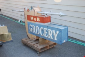
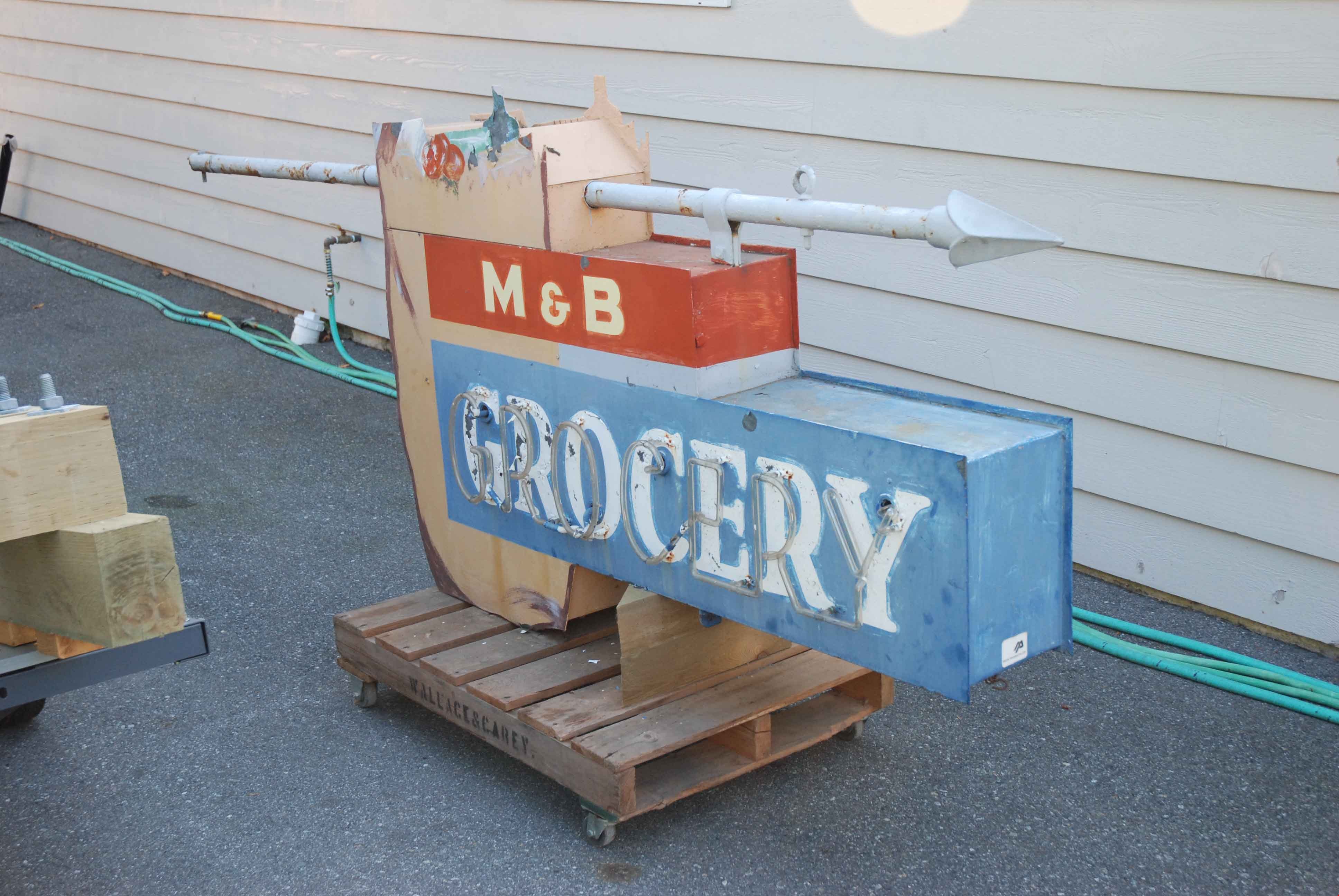
neon sign
https://search.heritageburnaby.ca/link/museumartifact83422
- Repository
- Burnaby Village Museum
- Accession Code
- BV013.15.1
- Description
- Grocery sign The sign is from a neighbourhood grocery on Royal Oak at the Skytrain line: 6949 Royal Oak Avenue. The bulk of the sign is rectangular with a grocery bag and contents extending above the top edge of the sign. The words "M & B / GROCERY" are written in white text, with "GROCERY" highlighted in neon. The sign was suspended from a horizontal pole with a spear like finial that was mounted at the front of the roof or the store.
- Province Made
- British Columbia
- Site/City Made
- Vancouver
- Historic Neighbourhood
- Central Park (Historic Neighbourhood)
- Planning Study Area
- Sussex-Nelson Area
Images

Neptune Wonton Noodle
https://search.heritageburnaby.ca/link/archivedescription95122
- Repository
- City of Burnaby Archives
- Date
- May 2, 2020
- Collection/Fonds
- Burnaby Photographic Society fonds
- Description Level
- Item
- Physical Description
- 1 photograph (tiff)
- Scope and Content
- Photograph of an empty Neptune Wonton Noodle restaurant at Station Square. The entrance to the restaurant is blocked off with chairs and an a rolling cart, with a sign instructing customers to wait to be seated propped up on one the chairs.
- Repository
- City of Burnaby Archives
- Date
- May 2, 2020
- Collection/Fonds
- Burnaby Photographic Society fonds
- Physical Description
- 1 photograph (tiff)
- Description Level
- Item
- Record No.
- 623-040
- Access Restriction
- No restrictions
- Reproduction Restriction
- No restrictions
- Accession Number
- 2020-10
- Scope and Content
- Photograph of an empty Neptune Wonton Noodle restaurant at Station Square. The entrance to the restaurant is blocked off with chairs and an a rolling cart, with a sign instructing customers to wait to be seated propped up on one the chairs.
- Media Type
- Photograph
- Photographer
- Cheung, Ray
- Notes
- Transcribed title
- Geographic Access
- Central Boulevard
- Street Address
- 4405 Central Boulevard
- Historic Neighbourhood
- Central Park (Historic Neighbourhood)
- Planning Study Area
- Maywood Area
Images


No playing here
https://search.heritageburnaby.ca/link/archivedescription95110
- Repository
- City of Burnaby Archives
- Date
- April 24, 2020
- Collection/Fonds
- Burnaby Photographic Society fonds
- Description Level
- Item
- Physical Description
- 1 photograph (tiff)
- Scope and Content
- Photograph of playground equipment taped off with caution tape at Royal Oakland Park. A red City of Burnaby facility closure sign posted to the playground is visible through the top of a slide.
- Repository
- City of Burnaby Archives
- Date
- April 24, 2020
- Collection/Fonds
- Burnaby Photographic Society fonds
- Physical Description
- 1 photograph (tiff)
- Description Level
- Item
- Record No.
- 623-028
- Access Restriction
- No restrictions
- Reproduction Restriction
- No restrictions
- Accession Number
- 2020-10
- Scope and Content
- Photograph of playground equipment taped off with caution tape at Royal Oakland Park. A red City of Burnaby facility closure sign posted to the playground is visible through the top of a slide.
- Media Type
- Photograph
- Photographer
- Snowdon, Nick
- Notes
- Transcribed title
- Photographer's caption: "Most playgrounds are taped off"
- Geographic Access
- Oakmount Crescent
- Historic Neighbourhood
- Central Park (Historic Neighbourhood)
- Planning Study Area
- Windsor Area
Images


Oak Theatre
https://search.heritageburnaby.ca/link/archivedescription37463
- Repository
- City of Burnaby Archives
- Date
- 1937 (date of original), copied 1991
- Collection/Fonds
- Burnaby Historical Society fonds
- Description Level
- Item
- Physical Description
- 1 photograph : b&w ; 4.6 x 3.3 cm print on contact sheet 20.2 x 25.3 cm
- Scope and Content
- Photograph of the Oak Theatre at 3506 Kingsway at night. This was the first commercial use of neon lighting in Burnaby. This photograph may have been taken opening night, August 4, 1937.
- Repository
- City of Burnaby Archives
- Date
- 1937 (date of original), copied 1991
- Collection/Fonds
- Burnaby Historical Society fonds
- Subseries
- Burnaby Image Bank subseries
- Physical Description
- 1 photograph : b&w ; 4.6 x 3.3 cm print on contact sheet 20.2 x 25.3 cm
- Description Level
- Item
- Record No.
- 370-051
- Access Restriction
- No restrictions
- Reproduction Restriction
- No known restrictions
- Accession Number
- BHS1999-03
- Scope and Content
- Photograph of the Oak Theatre at 3506 Kingsway at night. This was the first commercial use of neon lighting in Burnaby. This photograph may have been taken opening night, August 4, 1937.
- Names
- Oak Theatre
- Media Type
- Photograph
- Photographer
- Bellinger, Bernard
- Notes
- Title based on contents of photograph
- 1 b&w copy negative accompanying
- Geographic Access
- Kingsway
- Historic Neighbourhood
- Central Park (Historic Neighbourhood)
- Planning Study Area
- Marlborough Area
Images
