Narrow Results By
Subject
- Advertising Medium - Signs and Signboards 3
- Aerial Photographs 3
- Animals - Cats 3
- Animals - Dogs 1
- Animals - Poultry 1
- Buildings - Commercial 5
- Buildings - Commercial - Offices 4
- Buildings - Heritage 1
- Buildings - Residential 1
- Buildings - Residential - Houses 3
- Clothing 1
- Construction - Road Construction 1
Person / Organization
- Allard, Nancy Davis 1
- Bower, Janet Shankie 17
- British Columbia Electric Railway Company 1
- British Columbia Telephone Company 2
- Charles, Prince of Wales, 1948- 1
- Diana, Princess of Wales, 1961-1997 1
- Ellis, Bobby 1
- Lewarne, William A. "Bill" 1
- McKeeman, Ann 1
- McKeeman, Shannon 1
- Paterson, Bob 1
- Philips, Adell Greenwood 1

Boundary Road and Park Avenue station
https://search.heritageburnaby.ca/link/archivedescription36670
- Repository
- City of Burnaby Archives
- Date
- 1912 (date of original), copied 1992
- Collection/Fonds
- Burnaby Historical Society fonds
- Description Level
- Item
- Physical Description
- 1 photograph : b&w ; 10.1 x 14.9 cm print
- Scope and Content
- Photograph of Boundary Road, Park Avenue Interurban station, and the surrounding area, looking north from Kingsway. The Coburn house, built in 1906, is at the top of the hill on the right, current address 5170 Boundary Road.
- Repository
- City of Burnaby Archives
- Date
- 1912 (date of original), copied 1992
- Collection/Fonds
- Burnaby Historical Society fonds
- Subseries
- Burnaby Centennial Anthology subseries
- Physical Description
- 1 photograph : b&w ; 10.1 x 14.9 cm print
- Description Level
- Item
- Record No.
- 315-025
- Access Restriction
- No restrictions
- Reproduction Restriction
- No known restrictions
- Accession Number
- BHS1994-04
- Scope and Content
- Photograph of Boundary Road, Park Avenue Interurban station, and the surrounding area, looking north from Kingsway. The Coburn house, built in 1906, is at the top of the hill on the right, current address 5170 Boundary Road.
- Media Type
- Photograph
- Notes
- Title based on contents of photograph
- Annotation at bottom of photograph reads; "Boundary Rd and Park Ave Station"
- Geographic Access
- Boundary Road
- Kingsway
- Historic Neighbourhood
- Central Park (Historic Neighbourhood)
- Planning Study Area
- Garden Village Area
Images

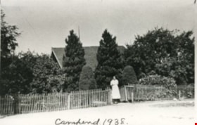
Campend
https://search.heritageburnaby.ca/link/archivedescription35144
- Repository
- City of Burnaby Archives
- Date
- 1938 (date of original), copied 1986
- Collection/Fonds
- Burnaby Historical Society fonds
- Description Level
- Item
- Physical Description
- 1 photograph : b&w ; 12.7 x 17.8 cm print
- Scope and Content
- Photograph of "Campend," the Shankie family home. Janet Shankie is standing in the gateway. The house was formerly numbered 3718 Barker Avenue and later renumbered 5155 Barker Avenue. An annotation at the bottom front of the photograph reads, "Campend 1938."
- Repository
- City of Burnaby Archives
- Date
- 1938 (date of original), copied 1986
- Collection/Fonds
- Burnaby Historical Society fonds
- Subseries
- Pioneer Tales subseries
- Physical Description
- 1 photograph : b&w ; 12.7 x 17.8 cm print
- Description Level
- Item
- Record No.
- 204-001
- Access Restriction
- No restrictions
- Reproduction Restriction
- No known restrictions
- Accession Number
- BHS1988-03
- Scope and Content
- Photograph of "Campend," the Shankie family home. Janet Shankie is standing in the gateway. The house was formerly numbered 3718 Barker Avenue and later renumbered 5155 Barker Avenue. An annotation at the bottom front of the photograph reads, "Campend 1938."
- Subjects
- Buildings - Residential - Houses
- Names
- Bower, Janet Shankie
- Media Type
- Photograph
- Notes
- Title based on caption on photograph
- Geographic Access
- Barker Avenue
- Street Address
- 5155 Barker Avenue
- Historic Neighbourhood
- Central Park (Historic Neighbourhood)
- Planning Study Area
- Garden Village Area
Images


Central Park testing station
https://search.heritageburnaby.ca/link/archivedescription95101
- Repository
- City of Burnaby Archives
- Date
- May 9, 2020
- Collection/Fonds
- Burnaby Photographic Society fonds
- Description Level
- Item
- Physical Description
- 1 photograph (tiff)
- Scope and Content
- Photograph of the COVID-19 testing station located in the Central Park parking lot off Boundary Road. A sign in the foreground reads "Covid-19 Care Site by Referral Only / Walk in Access". In the background, the white tents of the testing station are visible.
- Repository
- City of Burnaby Archives
- Date
- May 9, 2020
- Collection/Fonds
- Burnaby Photographic Society fonds
- Physical Description
- 1 photograph (tiff)
- Description Level
- Item
- Record No.
- 623-019
- Access Restriction
- No restrictions
- Reproduction Restriction
- No restrictions
- Accession Number
- 2020-10
- Scope and Content
- Photograph of the COVID-19 testing station located in the Central Park parking lot off Boundary Road. A sign in the foreground reads "Covid-19 Care Site by Referral Only / Walk in Access". In the background, the white tents of the testing station are visible.
- Subjects
- Geographic Features - Parks
- Geographic Features - Automobile Parking Lots
- Advertising Medium - Signs and Signboards
- Structures - Tents
- Media Type
- Photograph
- Photographer
- Damer, Eric
- Notes
- Transcribed title
- Geographic Access
- Boundary Road
- Central Park
- Historic Neighbourhood
- Central Park (Historic Neighbourhood)
- Planning Study Area
- Maywood Area
Images

![Digney Film 4 - Lawn bowling at Central Park, [196-] (date of original), copied 2019 thumbnail](/media/hpo/_Data/_BVM_Moving_Images/2019_0018_0006_004.jpg?width=280)
Digney Film 4 - Lawn bowling at Central Park
https://search.heritageburnaby.ca/link/museumdescription10658
- Repository
- Burnaby Village Museum
- Date
- [196-] (date of original), copied 2019
- Collection/Fonds
- Digney Family fonds
- Description Level
- Item
- Physical Description
- 1 video recording (mp4) (2 min., 9 sec.) : digital, 23 fps, col., si.
- Scope and Content
- Film segment of unidentified women and men lawn bowling at Central Park in Burnaby. Buildings along Kingsway and Boundary Road are visible in the background.
- Repository
- Burnaby Village Museum
- Collection/Fonds
- Digney Family fonds
- Description Level
- Item
- Physical Description
- 1 video recording (mp4) (2 min., 9 sec.) : digital, 23 fps, col., si.
- Scope and Content
- Film segment of unidentified women and men lawn bowling at Central Park in Burnaby. Buildings along Kingsway and Boundary Road are visible in the background.
- Creator
- Digney, Andy
- Subjects
- Sports - Lawn Bowling
- Geographic Access
- Central Park
- Boundary Road
- Kingsway
- Accession Code
- BV019.18.6.4
- Access Restriction
- No restrictions
- Reproduction Restriction
- No known restrictions
- Date
- [196-] (date of original), copied 2019
- Media Type
- Moving Images
- Historic Neighbourhood
- Central Park (Historic Neighbourhood)
- Photographer
- Digney, Ernest Frank "Dig"
- Notes
- Title based on contents of film segment
- Film segment originates from digitized version of original 8 mm film (See BV019.18.6)
Images
![Digney Film 4 - Lawn bowling at Central Park, [196-] (date of original), copied 2019 thumbnail](/media/hpo/_Data/_BVM_Moving_Images/2019_0018_0006_004.jpg)
Video
Digney Film 4 - Lawn bowling at Central Park, [196-] (date of original), copied 2019
Digney Film 4 - Lawn bowling at Central Park, [196-] (date of original), copied 2019
https://search.heritageburnaby.ca/media/hpo/_Data/_BVM_Moving_Images/2019_0018_0006_004.mp4![Digney Film 4 - Lawn bowling at Central Park, [196-] (date of original), copied 2019 thumbnail](/media/hpo/_Data/_BVM_Moving_Images/2019_0018_0006_007.jpg?width=280)
Digney Film 4 - Lawn bowling at Central Park
https://search.heritageburnaby.ca/link/museumdescription10659
- Repository
- Burnaby Village Museum
- Date
- [196-] (date of original), copied 2019
- Collection/Fonds
- Digney Family fonds
- Description Level
- Item
- Physical Description
- 1 video recording (mp4) (3 min., 22 sec.) : digital, 23 fps, col., si.
- Scope and Content
- Film segment of women and men lawn bowling at Central Park in Burnaby. Buildings along Kingsway and Boundary Road are visible in the background. Sydney Swan (wearing glasses and vest) is identified as one of the bowlers.
- Repository
- Burnaby Village Museum
- Collection/Fonds
- Digney Family fonds
- Description Level
- Item
- Physical Description
- 1 video recording (mp4) (3 min., 22 sec.) : digital, 23 fps, col., si.
- Scope and Content
- Film segment of women and men lawn bowling at Central Park in Burnaby. Buildings along Kingsway and Boundary Road are visible in the background. Sydney Swan (wearing glasses and vest) is identified as one of the bowlers.
- Creator
- Digney, Andy
- Subjects
- Sports - Lawn Bowling
- Names
- Swan, Sydney
- Geographic Access
- Central Park
- Boundary Road
- Kingsway
- Accession Code
- BV019.18.6.7
- Access Restriction
- No restrictions
- Reproduction Restriction
- No known restrictions
- Date
- [196-] (date of original), copied 2019
- Media Type
- Moving Images
- Historic Neighbourhood
- Central Park (Historic Neighbourhood)
- Planning Study Area
- Maywood Area
- Photographer
- Digney, Ernest Frank "Dig"
- Notes
- Title based on contents of film segment
- Film segment originates from digitized version of original 8 mm film (See BV019.18.6)
- Similar footage of lawn bowling - see BV019.18.6.8
Images
![Digney Film 4 - Lawn bowling at Central Park, [196-] (date of original), copied 2019 thumbnail](/media/hpo/_Data/_BVM_Moving_Images/2019_0018_0006_007.jpg)
Video
Digney Film 4 - Lawn bowling at Central Park, [196-] (date of original), copied 2019
Digney Film 4 - Lawn bowling at Central Park, [196-] (date of original), copied 2019
https://search.heritageburnaby.ca/media/hpo/_Data/_BVM_Moving_Images/2019_0018_0006_007.mp4![Home of Richard and Clara Thorpe, [1911] thumbnail](/media/hpo/_Data/_BVM_Images/1990/199900610001.jpg?width=280)
Home of Richard and Clara Thorpe
https://search.heritageburnaby.ca/link/museumdescription1507
- Repository
- Burnaby Village Museum
- Date
- [1911]
- Collection/Fonds
- Burnaby Village Museum Photograph collection
- Description Level
- Item
- Physical Description
- 1 photograph : b&w ; 10x 14 cm, mounted on card 15 x 22.5 cm
- Scope and Content
- Photograph of the home of Richard and Clara Thorpe. Nancy Davis Allard is standing, holding baby Dorothy Thorp (later Spain) upright in a buggy at the foot of the stairs. Two unidentified woman are also visible sitting at the top of the stairs.
- Repository
- Burnaby Village Museum
- Collection/Fonds
- Burnaby Village Museum Photograph collection
- Description Level
- Item
- Physical Description
- 1 photograph : b&w ; 10x 14 cm, mounted on card 15 x 22.5 cm
- Scope and Content
- Photograph of the home of Richard and Clara Thorpe. Nancy Davis Allard is standing, holding baby Dorothy Thorp (later Spain) upright in a buggy at the foot of the stairs. Two unidentified woman are also visible sitting at the top of the stairs.
- Subjects
- Buildings - Residential - Houses
- Geographic Access
- Boundary Road
- Burke Street
- Accession Code
- BV999.61.1
- Access Restriction
- No restrictions
- Date
- [1911]
- Media Type
- Photograph
- Historic Neighbourhood
- Central Park (Historic Neighbourhood)
- Planning Study Area
- Garden Village Area
- Scan Resolution
- 600
- Scan Date
- 09-Jun-09
- Scale
- 100
- Notes
- Title based on contents of photograph
- Note in blue ink on verso of photograph reads: "Home of Richard and/ Clara Thorp - about 1911./ Built in 1907. Boundary/ & Burke St. - Burnaby/ I'm in the buggy, held upright by my/ dear friend Nance -"
Images
![Home of Richard and Clara Thorpe, [1911] thumbnail](/media/hpo/_Data/_BVM_Images/1990/199900610001.jpg)
![House and garden with Thomas and Bertha Shankie and cat, 1920 (date of original), copied [2016] thumbnail](/media/hpo/_Data/_BVM_Images/2016/201600430066_001.jpg?width=280)
House and garden with Thomas and Bertha Shankie and cat
https://search.heritageburnaby.ca/link/museumdescription4167
- Repository
- Burnaby Village Museum
- Date
- 1920 (date of original), copied [2016]
- Collection/Fonds
- Esther Love Stanley fonds
- Description Level
- Item
- Physical Description
- 1 photograph (tiff)
- Scope and Content
- Photograph of Thomas and Bertha Shankie standing in the front garden of the Shankie family home on Barker Avenue. The man is holding a cat. There is a sign on the house that reads "CAMPEND". A picket fence with a gate runs along the front of the property.
- Repository
- Burnaby Village Museum
- Collection/Fonds
- Esther Love Stanley fonds
- Description Level
- Item
- Physical Description
- 1 photograph (tiff)
- Material Details
- Handwritten text on back reads: "Mom & Dad & Barker St. house / 1920".
- Scope and Content
- Photograph of Thomas and Bertha Shankie standing in the front garden of the Shankie family home on Barker Avenue. The man is holding a cat. There is a sign on the house that reads "CAMPEND". A picket fence with a gate runs along the front of the property.
- Geographic Access
- Barker Avenue
- Street Address
- 5515 Barker Avenue
- Accession Code
- BV016.43.66
- Access Restriction
- No restrictions
- Reproduction Restriction
- May be restricted by third party rights
- Date
- 1920 (date of original), copied [2016]
- Media Type
- Photograph
- Historic Neighbourhood
- Central Park (Historic Neighbourhood)
- Planning Study Area
- Garden Village Area
- Notes
- Title based on contents of photograph.
- Image is from a binder of family history. Binder 3, fruit illustrations on cover, "Family Tree Photos".
- Digital image created from orginal photograph by donor
Images
![House and garden with Thomas and Bertha Shankie and cat, 1920 (date of original), copied [2016] thumbnail](/media/hpo/_Data/_BVM_Images/2016/201600430066_001.jpg)

House at 5170 Boundary Road
https://search.heritageburnaby.ca/link/archivedescription78963
- Repository
- City of Burnaby Archives
- Date
- September 9,1976
- Collection/Fonds
- Burnaby Public Library Contemporary Visual Archive Project
- Description Level
- Item
- Physical Description
- 1 photograph : b&w ; 11 x 16 cm mounted on cardboard
- Scope and Content
- Photograph shows a house at 5170 Boundary Road on the corner of Burke Street. The house was constructed in 1911. The home is known as the Minerva Jane Coburn house.
- Repository
- City of Burnaby Archives
- Date
- September 9,1976
- Collection/Fonds
- Burnaby Public Library Contemporary Visual Archive Project
- Physical Description
- 1 photograph : b&w ; 11 x 16 cm mounted on cardboard
- Description Level
- Item
- Record No.
- 556-054
- Access Restriction
- No restrictions
- Reproduction Restriction
- Reproduce for fair dealing purposes only
- Accession Number
- 2013-13
- Scope and Content
- Photograph shows a house at 5170 Boundary Road on the corner of Burke Street. The house was constructed in 1911. The home is known as the Minerva Jane Coburn house.
- Subjects
- Buildings - Heritage
- Media Type
- Photograph
- Photographer
- Norton, Paul
- Notes
- Scope note taken directly from BPL photograph description.
- 1 b&w copy negative : 10 x 12.5 cm accompanying
- Geographic Access
- Boundary Road
- Street Address
- 5170 Boundary Road
- Historic Neighbourhood
- Central Park (Historic Neighbourhood)
- Planning Study Area
- Garden Village Area
Images

![Icicles on Barker Avenue house, [196-] thumbnail](/media/hpo/_Data/_BVM_Images/2022/2022_0011_0003_001.jpg?width=280)
Icicles on Barker Avenue house
https://search.heritageburnaby.ca/link/museumdescription19084
- Repository
- Burnaby Village Museum
- Date
- [196-]
- Collection/Fonds
- Earl and Adell Philips family fonds
- Description Level
- Item
- Physical Description
- 1 photograph : b&w ; 11.5 x 7 cm
- Scope and Content
- Photograph of icicles hanging from the roof of the Philips family home at 5877 Barker Avenue in Burnaby.
- Repository
- Burnaby Village Museum
- Collection/Fonds
- Earl and Adell Philips family fonds
- Description Level
- Item
- Physical Description
- 1 photograph : b&w ; 11.5 x 7 cm
- Scope and Content
- Photograph of icicles hanging from the roof of the Philips family home at 5877 Barker Avenue in Burnaby.
- Geographic Access
- Barker Avenue
- Street Address
- 5877 Barker Avenue
- Accession Code
- BV022.11.3
- Access Restriction
- No restrictions
- Reproduction Restriction
- No known restrictions
- Date
- [196-]
- Media Type
- Photograph
- Historic Neighbourhood
- Central Park (Historic Neighbourhood)
- Notes
- Title based on contents of photograph
- Note in pencil on verso of photograph reads: "Barker Avenue / #81"
- Stamp in black ink on verso of photograph reads: "033"
Images
![Icicles on Barker Avenue house, [196-] thumbnail](/media/hpo/_Data/_BVM_Images/2022/2022_0011_0003_001.jpg)
![Janet and Ramsay Shankie in garden, [14 May 1926] (date of original), copied [2016] thumbnail](/media/hpo/_Data/_BVM_Images/2016/201600430024_001.jpg?width=280)
Janet and Ramsay Shankie in garden
https://search.heritageburnaby.ca/link/museumdescription4124
- Repository
- Burnaby Village Museum
- Date
- [14 May 1926] (date of original), copied [2016]
- Collection/Fonds
- Esther Love Stanley fonds
- Description Level
- Item
- Physical Description
- 1 photograph (tiff)
- Scope and Content
- Photograph of Janet and Ramsay Shankie standing in a garden. Janet is wearing a light coloured dress and is holding a small violin. Ramsay is wearing a white shirt, necktie, and dark shorts. The family's Barker Avenue home and yard is visible behind them.
- Repository
- Burnaby Village Museum
- Collection/Fonds
- Esther Love Stanley fonds
- Description Level
- Item
- Physical Description
- 1 photograph (tiff)
- Material Details
- Handwritten text in white on front of photograph reads: "14 may 1926".
- Scope and Content
- Photograph of Janet and Ramsay Shankie standing in a garden. Janet is wearing a light coloured dress and is holding a small violin. Ramsay is wearing a white shirt, necktie, and dark shorts. The family's Barker Avenue home and yard is visible behind them.
- Subjects
- Musical Instruments
- Geographic Access
- Barker Avenue
- Street Address
- 5515 Barker Avenue
- Accession Code
- BV016.43.24
- Access Restriction
- No restrictions
- Reproduction Restriction
- May be restricted by third party rights
- Date
- [14 May 1926] (date of original), copied [2016]
- Media Type
- Photograph
- Historic Neighbourhood
- Central Park (Historic Neighbourhood)
- Planning Study Area
- Garden Village Area
- Notes
- Title based on contents of photograph.
- Image is from a binder of family history. Binder 1, orange cover "Old Stanley Family Photo / Old Shankie Family Photos / War Photos - Echo Photos".
- Digital image created from orginal photograph by donor
Images
![Janet and Ramsay Shankie in garden, [14 May 1926] (date of original), copied [2016] thumbnail](/media/hpo/_Data/_BVM_Images/2016/201600430024_001.jpg)

Janet Shankie
https://search.heritageburnaby.ca/link/archivedescription35146
- Repository
- City of Burnaby Archives
- Date
- 1931 (date of original), copied 1986
- Collection/Fonds
- Burnaby Historical Society fonds
- Description Level
- Item
- Physical Description
- 1 photograph : b&w ; 12.7 x 17.8 cm print
- Scope and Content
- Photograph of Janet Bower (nee Shankie) in Scottish regalia. The house was formerly numbered 3718 Barker Avenue and later renumbered 5155 Barker Avenue.
- Repository
- City of Burnaby Archives
- Date
- 1931 (date of original), copied 1986
- Collection/Fonds
- Burnaby Historical Society fonds
- Subseries
- Pioneer Tales subseries
- Physical Description
- 1 photograph : b&w ; 12.7 x 17.8 cm print
- Description Level
- Item
- Record No.
- 204-003
- Access Restriction
- No restrictions
- Reproduction Restriction
- No known restrictions
- Accession Number
- BHS1988-03
- Scope and Content
- Photograph of Janet Bower (nee Shankie) in Scottish regalia. The house was formerly numbered 3718 Barker Avenue and later renumbered 5155 Barker Avenue.
- Subjects
- Clothing
- Names
- Bower, Janet Shankie
- Media Type
- Photograph
- Notes
- Title based on contents of photograph
- Geographic Access
- Barker Avenue
- Street Address
- 5155 Barker Avenue
- Historic Neighbourhood
- Central Park (Historic Neighbourhood)
- Planning Study Area
- Garden Village Area
Images

Janet Shankie and friends
https://search.heritageburnaby.ca/link/archivedescription35147
- Repository
- City of Burnaby Archives
- Date
- 1927 (date of original), copied 1986
- Collection/Fonds
- Burnaby Historical Society fonds
- Description Level
- Item
- Physical Description
- 1 photograph : b&w ; 12.7 x 17.8 cm print
- Scope and Content
- Photograph of Janet Shankie (front right) with brother Thomas Ramsay Hunter Shankie (back right) and neighbourhood friends: Margaret, Tom and Betty. The house was formerly numbered 3718 Barker Avenue and later renumbered 5155 Barker Avenue.
- Repository
- City of Burnaby Archives
- Date
- 1927 (date of original), copied 1986
- Collection/Fonds
- Burnaby Historical Society fonds
- Subseries
- Pioneer Tales subseries
- Physical Description
- 1 photograph : b&w ; 12.7 x 17.8 cm print
- Description Level
- Item
- Record No.
- 204-004
- Access Restriction
- No restrictions
- Reproduction Restriction
- No known restrictions
- Accession Number
- BHS1988-03
- Scope and Content
- Photograph of Janet Shankie (front right) with brother Thomas Ramsay Hunter Shankie (back right) and neighbourhood friends: Margaret, Tom and Betty. The house was formerly numbered 3718 Barker Avenue and later renumbered 5155 Barker Avenue.
- Subjects
- Toys - Dolls
- Media Type
- Photograph
- Notes
- Title based on contents of photograph
- Geographic Access
- Barker Avenue
- Street Address
- 5155 Barker Avenue
- Historic Neighbourhood
- Central Park (Historic Neighbourhood)
- Planning Study Area
- Garden Village Area
Images

Kingsway
https://search.heritageburnaby.ca/link/archivedescription34510
- Repository
- City of Burnaby Archives
- Date
- 1920
- Collection/Fonds
- Burnaby Historical Society fonds
- Description Level
- Item
- Physical Description
- 1 photograph : sepia ; 12.6 x 17.7 cm
- Scope and Content
- Photograph of Kingsway looking east at Boundary Road. A sign on the right reads, "Burnaby / Vehicles must slow down at all schools and intersections marked thus: X." A sign on a building at the left reads, "Arctic Ice Cream." Central Park is on the right.
- Repository
- City of Burnaby Archives
- Date
- 1920
- Collection/Fonds
- Burnaby Historical Society fonds
- Subseries
- Photographs subseries
- Physical Description
- 1 photograph : sepia ; 12.6 x 17.7 cm
- Description Level
- Item
- Record No.
- 031-001
- Access Restriction
- No restrictions
- Reproduction Restriction
- No known restrictions
- Accession Number
- BHS2007-04
- Scope and Content
- Photograph of Kingsway looking east at Boundary Road. A sign on the right reads, "Burnaby / Vehicles must slow down at all schools and intersections marked thus: X." A sign on a building at the left reads, "Arctic Ice Cream." Central Park is on the right.
- Media Type
- Photograph
- Notes
- Title based on contents of photograph
- Geographic Access
- Kingsway
- Central Park
- Boundary Road
- Historic Neighbourhood
- Central Park (Historic Neighbourhood)
- Planning Study Area
- Garden Village Area
- Maywood Area
Images


Kingsway
https://search.heritageburnaby.ca/link/archivedescription34511
- Repository
- City of Burnaby Archives
- Date
- 1920
- Collection/Fonds
- Burnaby Historical Society fonds
- Description Level
- Item
- Physical Description
- 1 photograph : sepia ; 12.6 x 17.6 cm
- Scope and Content
- Photograph of Kingsway looking east at Boundary Road. A sign on the right reads, "Burnaby / Vehicles must slow down at all schools and intersections marked thus: X." A sign on a building at the left reads, "Arctic Ice Cream." Central Park is on the right.
- Repository
- City of Burnaby Archives
- Date
- 1920
- Collection/Fonds
- Burnaby Historical Society fonds
- Subseries
- Photographs subseries
- Physical Description
- 1 photograph : sepia ; 12.6 x 17.6 cm
- Description Level
- Item
- Record No.
- 031-002
- Access Restriction
- No restrictions
- Reproduction Restriction
- No known restrictions
- Accession Number
- BHS2007-04
- Scope and Content
- Photograph of Kingsway looking east at Boundary Road. A sign on the right reads, "Burnaby / Vehicles must slow down at all schools and intersections marked thus: X." A sign on a building at the left reads, "Arctic Ice Cream." Central Park is on the right.
- Subjects
- Geographic Features - Roads
- Advertising Medium - Signs and Signboards
- Transportation - Automobiles
- Media Type
- Photograph
- Notes
- Title based on contents of photograph
- Geographic Access
- Kingsway
- Central Park
- Boundary Road
- Historic Neighbourhood
- Central Park (Historic Neighbourhood)
- Planning Study Area
- Garden Village Area
- Maywood Area
Images

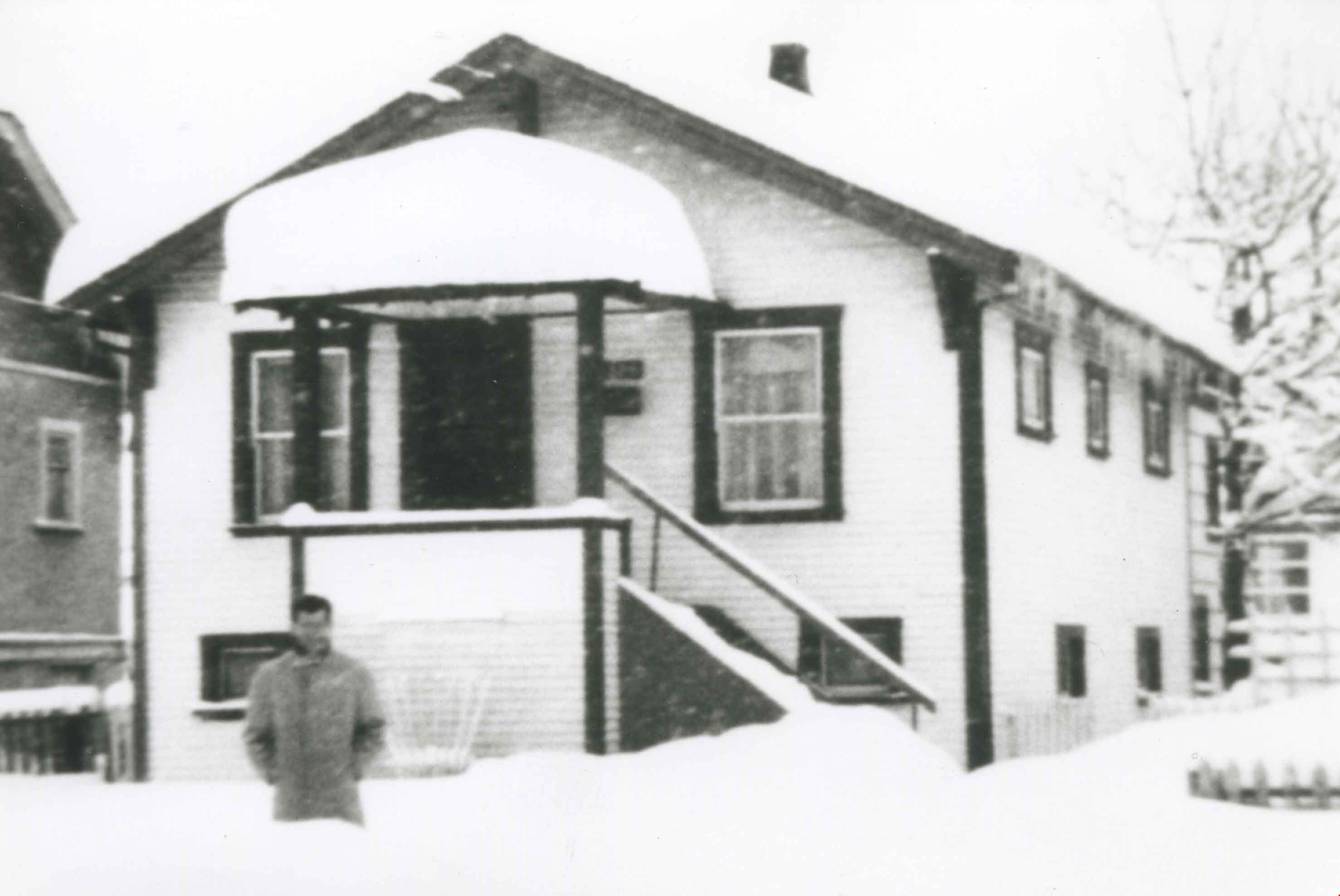
Langford family home
https://search.heritageburnaby.ca/link/archivedescription37014
- Repository
- City of Burnaby Archives
- Date
- 1931 (date of original), copied 1992
- Collection/Fonds
- Burnaby Historical Society fonds
- Description Level
- Item
- Physical Description
- 1 photograph : b&w ; 8.7 x 12.6 cm print
- Scope and Content
- Photograph of the Langford family home at 3509 Barker Avenue (one door south of Kingsway) in the snow. A man is standing in front.
- Repository
- City of Burnaby Archives
- Date
- 1931 (date of original), copied 1992
- Collection/Fonds
- Burnaby Historical Society fonds
- Subseries
- Burnaby Centennial Anthology subseries
- Physical Description
- 1 photograph : b&w ; 8.7 x 12.6 cm print
- Description Level
- Item
- Record No.
- 315-477
- Access Restriction
- No restrictions
- Reproduction Restriction
- No known restrictions
- Accession Number
- BHS1994-04
- Scope and Content
- Photograph of the Langford family home at 3509 Barker Avenue (one door south of Kingsway) in the snow. A man is standing in front.
- Media Type
- Photograph
- Notes
- Title based on contents of photograph
- Geographic Access
- Barker Avenue
- Kingsway
- Street Address
- 5806 Barker Avenue
- Historic Neighbourhood
- Central Park (Historic Neighbourhood)
- Planning Study Area
- Maywood Area
Images

Municipal Road Crew
https://search.heritageburnaby.ca/link/archivedescription79439
- Repository
- City of Burnaby Archives
- Date
- September 23, 1976
- Collection/Fonds
- Burnaby Public Library Contemporary Visual Archive Project
- Description Level
- Item
- Physical Description
- 1 photograph : b&w ; 11 x 16 cm mounted on cardboard
- Scope and Content
- Photograph shows a municipal road crew resurfacing Boundary Road near Imperial Street.
- Repository
- City of Burnaby Archives
- Date
- September 23, 1976
- Collection/Fonds
- Burnaby Public Library Contemporary Visual Archive Project
- Physical Description
- 1 photograph : b&w ; 11 x 16 cm mounted on cardboard
- Description Level
- Item
- Record No.
- 556-291
- Access Restriction
- No restrictions
- Reproduction Restriction
- Reproduce for fair dealing purposes only
- Accession Number
- 2013-13
- Scope and Content
- Photograph shows a municipal road crew resurfacing Boundary Road near Imperial Street.
- Media Type
- Photograph
- Photographer
- Ross, Martha
- Notes
- Scope note taken directly from BPL photograph description.
- 1 b&w copy negative : 10 x 12.5 cm accompanying
- Geographic Access
- Boundary Road
- Imperial Street
- Historic Neighbourhood
- Central Park (Historic Neighbourhood)
- Planning Study Area
- Suncrest Area
Images

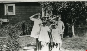
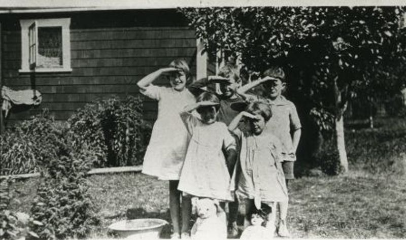
![Philips family in dining room at Christmas, [Jan. 1962] thumbnail](/media/hpo/_Data/_BVM_Images/2022/2022_0011_0002_001.jpg?width=280)
Philips family in dining room at Christmas
https://search.heritageburnaby.ca/link/museumdescription19083
- Repository
- Burnaby Village Museum
- Date
- [Jan. 1962]
- Collection/Fonds
- Earl and Adell Philips family fonds
- Description Level
- Item
- Physical Description
- 1 photograph : b&w ; 9 x 9 cm
- Scope and Content
- Photograph of the Philips family seated around a table in their dining room of their house located at 5877 Barker Avenue, Burnaby. People are identified from left to right: Shannon McKeemen and Ann McKeemen, Bob Paterson, Earl Philips, Adell Philips, Lorayne Philips, Cory Philips, Lea Philips, Ju…
- Repository
- Burnaby Village Museum
- Collection/Fonds
- Earl and Adell Philips family fonds
- Description Level
- Item
- Physical Description
- 1 photograph : b&w ; 9 x 9 cm
- Scope and Content
- Photograph of the Philips family seated around a table in their dining room of their house located at 5877 Barker Avenue, Burnaby. People are identified from left to right: Shannon McKeemen and Ann McKeemen, Bob Paterson, Earl Philips, Adell Philips, Lorayne Philips, Cory Philips, Lea Philips, Judith Philips. Photograph was taken during Christmas, everyone is wearing a tissue paper hat and the table cloth has a pointsettia design.
- Names
- Philips, Adell Greenwood
- Philips, Judith
- Philips, Lea
- Philips, Lorayne
- Philips, Earl Gene
- Philips, Cory
- McKeeman, Ann
- McKeeman, Shannon
- Paterson, Bob
- Geographic Access
- Barker Avenue
- Street Address
- 5877 Barker Avenue
- Accession Code
- BV022.11.2
- Access Restriction
- No restrictions
- Reproduction Restriction
- No known restrictions
- Date
- [Jan. 1962]
- Media Type
- Photograph
- Historic Neighbourhood
- Central Park (Historic Neighbourhood)
- Notes
- Title based on contents of photograph
- Stamp along right edge of photo includes print date which reads: "JAN. 62"
- Note in pencil on verso of photograph reads: "Barker Ave. / Christmas 1961"
Images
![Philips family in dining room at Christmas, [Jan. 1962] thumbnail](/media/hpo/_Data/_BVM_Images/2022/2022_0011_0002_001.jpg)
![Ramsay and Janet Shankie, [between 1926 and 1930] (date of original), copied [2016] thumbnail](/media/hpo/_Data/_BVM_Images/2015/2015_0040_0039.jpg?width=280)
Ramsay and Janet Shankie
https://search.heritageburnaby.ca/link/museumdescription5606
- Repository
- Burnaby Village Museum
- Date
- [between 1926 and 1930] (date of original), copied [2016]
- Collection/Fonds
- Esther Love Stanley fonds
- Description Level
- Item
- Physical Description
- 1 photograph (jpg)
- Scope and Content
- Photograph of young boy, Thomas Ramsay Shankie, and his sister, Janet Shankie Bower, pictured in the garden beside the family home on Barker Avenue. Ramsay is on the left and is playing the violin.
- Repository
- Burnaby Village Museum
- Collection/Fonds
- Esther Love Stanley fonds
- Description Level
- Item
- Physical Description
- 1 photograph (jpg)
- Scope and Content
- Photograph of young boy, Thomas Ramsay Shankie, and his sister, Janet Shankie Bower, pictured in the garden beside the family home on Barker Avenue. Ramsay is on the left and is playing the violin.
- Subjects
- Musical Instruments
- Geographic Access
- Barker Avenue
- Street Address
- 5515 Barker Avenue
- Accession Code
- BV015.40.39
- Access Restriction
- No restrictions
- Reproduction Restriction
- No known restrictions
- Date
- [between 1926 and 1930] (date of original), copied [2016]
- Media Type
- Photograph
- Historic Neighbourhood
- Central Park (Historic Neighbourhood)
- Planning Study Area
- Garden Village Area
- Scan Resolution
- 300
- Scan Date
- 09-Sep-18
- Notes
- Title based on annotations on digital file name
- Digital image created from orginal photograph by donor
Images
![Ramsay and Janet Shankie, [between 1926 and 1930] (date of original), copied [2016] thumbnail](/media/hpo/_Data/_BVM_Images/2015/2015_0040_0039.jpg)
![Ramsay and Janet Shankie in a garden, 2 Jul. 1928 (date of original), copied [2016] thumbnail](/media/hpo/_Data/_BVM_Images/2016/201600430034_001.jpg?width=280)
Ramsay and Janet Shankie in a garden
https://search.heritageburnaby.ca/link/museumdescription4134
- Repository
- Burnaby Village Museum
- Date
- 2 Jul. 1928 (date of original), copied [2016]
- Collection/Fonds
- Esther Love Stanley fonds
- Description Level
- Item
- Physical Description
- 1 photograph (tiff)
- Scope and Content
- Photograph of Ramsay and Janet Shankie in the yard of the family home on Barker Avenue. Ramsay is standing on a push scooter beside a bench. He wearing a light coloured shirt and dark shorts. A very blurry second child (identified as Janet Shankie) can be seen standing on a moving swing above Ramsa…
- Repository
- Burnaby Village Museum
- Collection/Fonds
- Esther Love Stanley fonds
- Description Level
- Item
- Physical Description
- 1 photograph (tiff)
- Material Details
- Handwritten text in white on front of photograph reads: "2nd July 1928".
- Scope and Content
- Photograph of Ramsay and Janet Shankie in the yard of the family home on Barker Avenue. Ramsay is standing on a push scooter beside a bench. He wearing a light coloured shirt and dark shorts. A very blurry second child (identified as Janet Shankie) can be seen standing on a moving swing above Ramsay.
- Subjects
- Recreational Devices - Swings
- Geographic Access
- Barker Avenue
- Street Address
- 5515 Barker Avenue
- Accession Code
- BV016.43.34
- Access Restriction
- No restrictions
- Reproduction Restriction
- May be restricted by third party rights
- Date
- 2 Jul. 1928 (date of original), copied [2016]
- Media Type
- Photograph
- Historic Neighbourhood
- Central Park (Historic Neighbourhood)
- Planning Study Area
- Garden Village Area
- Notes
- Title based on contents of photograph.
- Image is from a binder of family history. Binder 1, orange cover "Old Stanley Family Photo / Old Shankie Family Photos / War Photos - Echo Photos".
- Digital image created from orginal photograph by donor
Images
![Ramsay and Janet Shankie in a garden, 2 Jul. 1928 (date of original), copied [2016] thumbnail](/media/hpo/_Data/_BVM_Images/2016/201600430034_001.jpg)
![Ramsay and Janet Shankie in outdoor bathtub, 9 Aug 1931 (date of original), copied [2016] thumbnail](/media/hpo/_Data/_BVM_Images/2016/201600430035_001.jpg?width=280)
Ramsay and Janet Shankie in outdoor bathtub
https://search.heritageburnaby.ca/link/museumdescription4135
- Repository
- Burnaby Village Museum
- Date
- 9 Aug 1931 (date of original), copied [2016]
- Collection/Fonds
- Esther Love Stanley fonds
- Description Level
- Item
- Physical Description
- 1 photograph (tiff)
- Scope and Content
- Photograph of Ramsay and Janet Shankie in a garden, standing in a metal bathtub with a rooster standing next to them. The children are wearing bathing suits. A leafy tree and the Shankie family home on Barker Avenue is visible in the background.
- Repository
- Burnaby Village Museum
- Collection/Fonds
- Esther Love Stanley fonds
- Description Level
- Item
- Physical Description
- 1 photograph (tiff)
- Material Details
- Handwritten text in white on front of photograph reads: "9th Aug 1931".
- Scope and Content
- Photograph of Ramsay and Janet Shankie in a garden, standing in a metal bathtub with a rooster standing next to them. The children are wearing bathing suits. A leafy tree and the Shankie family home on Barker Avenue is visible in the background.
- Geographic Access
- Barker Avenue
- Street Address
- 5515 Barker Avenue
- Accession Code
- BV016.43.35
- Access Restriction
- No restrictions
- Reproduction Restriction
- May be restricted by third party rights
- Date
- 9 Aug 1931 (date of original), copied [2016]
- Media Type
- Photograph
- Historic Neighbourhood
- Central Park (Historic Neighbourhood)
- Planning Study Area
- Garden Village Area
- Notes
- Title based on contents of photograph.
- Image is from a binder of family history. Binder 1, orange cover "Old Stanley Family Photo / Old Shankie Family Photos / War Photos - Echo Photos".
- Digital image created from orginal photograph by donor
Images
![Ramsay and Janet Shankie in outdoor bathtub, 9 Aug 1931 (date of original), copied [2016] thumbnail](/media/hpo/_Data/_BVM_Images/2016/201600430035_001.jpg)