Narrow Results By
Subject
- Buildings - Commercial - Beauty Shops 1
- Buildings - Residential - Houses 1
- Buildings - Schools 3
- Cemeteries 8
- Construction - Road Construction 1
- Fountains 1
- Gardens
- Geographic Features - Forests 1
- Geographic Features - Roads 3
- Indigenous peoples - British Columbia 1
- Occupations - Civic Workers
- Persons - Japanese Canadians
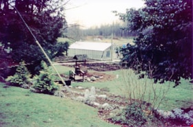
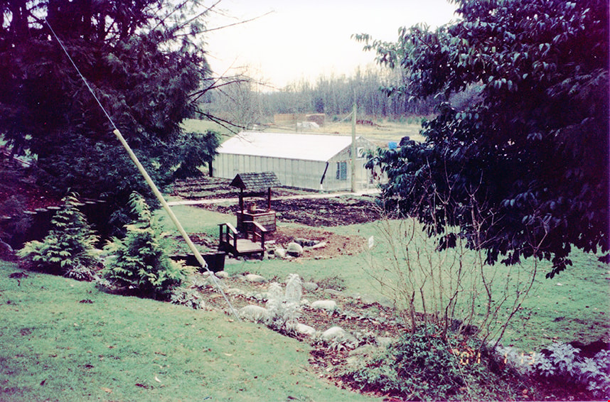
Grounds and green house at New Haven
https://search.heritageburnaby.ca/link/museumdescription13538
- Repository
- Burnaby Village Museum
- Date
- Jan. 2001
- Collection/Fonds
- Burnaby Village Museum Photograph collection
- Description Level
- Item
- Physical Description
- 1 photograph : col. ; 5.3 x 10 cm
- Scope and Content
- Photograph of a greenhouse and a section of the grounds of New Haven Correctional Centre. Grounds near the greenhouse include trees, vegetable and flower gardens, a wishing well and foot bridge.
- Repository
- Burnaby Village Museum
- Collection/Fonds
- Burnaby Village Museum Photograph collection
- Description Level
- Item
- Physical Description
- 1 photograph : col. ; 5.3 x 10 cm
- Scope and Content
- Photograph of a greenhouse and a section of the grounds of New Haven Correctional Centre. Grounds near the greenhouse include trees, vegetable and flower gardens, a wishing well and foot bridge.
- History
- In 1937 New Haven Correctional Centre was established as the British Columbia Training School on the southeast side of Marine Drive in Burnaby (4250 Marine Drive). Sections of Sussex and Patterson Avenues bordered the estate. Originally, the facility housed nineteen inmates with two staff and was one of the first initiatives in Canada to segregate young adult inmates into a separate institution apart from adults. This was part of the Borstal system that started in England whereby young male offenders between the ages of sixteen and twenty one were trained to earn an honest living. Alterations and additions to the estate took place between December 1937 and October 1939 so that more inmates could be accomodated. Five new cottages were built that could hold up to forty people. Except for the plastering and lighting, all work on the new cottages was done by the inmates. On October 29, 1939, the Lieutenant-Governor Eric Hamber formally opened the New Haven Borstal School. World War II interrupted full development of the intstitution and it was closed in 1941 when the inmates were were conscripted into the army. Between 1941 and 1947 the Deaf and Blind Institute were housed at New Haven. In 1947, the New Haven Borstal School returned to the estate. New additions were added to old buildings and new additional buildings were erected on the site over the years including a warden's house on the east grounds and a barn and gymnasium. In the 1970s an equipment shed was added along with another dormitory and a variety of small sheds and storage buildings. The correctional centre officially closed in March 2001.
- Subjects
- Public Services - Correctional
- Gardens
- Geographic Access
- Marine Drive
- Street Address
- 4250 Marine Drive
- Accession Code
- BV020.5.881
- Access Restriction
- No restrictions
- Reproduction Restriction
- No known restrictions
- Date
- Jan. 2001
- Media Type
- Photograph
- Historic Neighbourhood
- Fraser Arm (Historic Neighbourhood)
- Planning Study Area
- Suncrest Area
- Scan Resolution
- 600
- Scan Date
- 25-Aug-2020
- Scale
- 100
- Notes
- Title based on contents of photograph
- Photograph processing stamp on front of photograph reads: "'01_1_13"
- Historical information based on notes from Mary Forsyth's research notes "New Haven" MSS185-018
Images

Municipal Road Crew
https://search.heritageburnaby.ca/link/archivedescription79439
- Repository
- City of Burnaby Archives
- Date
- September 23, 1976
- Collection/Fonds
- Burnaby Public Library Contemporary Visual Archive Project
- Description Level
- Item
- Physical Description
- 1 photograph : b&w ; 11 x 16 cm mounted on cardboard
- Scope and Content
- Photograph shows a municipal road crew resurfacing Boundary Road near Imperial Street.
- Repository
- City of Burnaby Archives
- Date
- September 23, 1976
- Collection/Fonds
- Burnaby Public Library Contemporary Visual Archive Project
- Physical Description
- 1 photograph : b&w ; 11 x 16 cm mounted on cardboard
- Description Level
- Item
- Record No.
- 556-291
- Access Restriction
- No restrictions
- Reproduction Restriction
- Reproduce for fair dealing purposes only
- Accession Number
- 2013-13
- Scope and Content
- Photograph shows a municipal road crew resurfacing Boundary Road near Imperial Street.
- Media Type
- Photograph
- Photographer
- Ross, Martha
- Notes
- Scope note taken directly from BPL photograph description.
- 1 b&w copy negative : 10 x 12.5 cm accompanying
- Geographic Access
- Boundary Road
- Imperial Street
- Historic Neighbourhood
- Central Park (Historic Neighbourhood)
- Planning Study Area
- Suncrest Area
Images

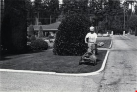
Municipal Worker Mowing Lawn
https://search.heritageburnaby.ca/link/archivedescription79442
- Repository
- City of Burnaby Archives
- Date
- September 8, 1976
- Collection/Fonds
- Burnaby Public Library Contemporary Visual Archive Project
- Description Level
- Item
- Physical Description
- 1 photograph : b&w ; 11 x 16 cm mounted on cardboard
- Scope and Content
- Photograph of a Burnaby Municipal outside division worker mowing a lawn at Ocean View Memorial Park on Imperial Street.
- Repository
- City of Burnaby Archives
- Date
- September 8, 1976
- Collection/Fonds
- Burnaby Public Library Contemporary Visual Archive Project
- Physical Description
- 1 photograph : b&w ; 11 x 16 cm mounted on cardboard
- Description Level
- Item
- Record No.
- 556-294
- Access Restriction
- No restrictions
- Reproduction Restriction
- Reproduce for fair dealing purposes only
- Accession Number
- 2013-13
- Scope and Content
- Photograph of a Burnaby Municipal outside division worker mowing a lawn at Ocean View Memorial Park on Imperial Street.
- Subjects
- Occupations - Civic Workers
- Cemeteries
- Names
- Ocean View Burial Park
- Media Type
- Photograph
- Photographer
- Ross, Martha
- Notes
- Scope note taken directly from BPL photograph description.
- 1 b&w copy negative : 10 x 12.5 cm accompanying
- Geographic Access
- Imperial Street
- Street Address
- 4000 Imperial Street
- Historic Neighbourhood
- Alta-Vista (Historic Neighbourhood)
- Planning Study Area
- Suncrest Area
Images

Prisons & Reformatories in Early Burnaby
https://search.heritageburnaby.ca/link/museumdescription14759
- Repository
- Burnaby Village Museum
- Date
- 15 Oct. 2020
- Collection/Fonds
- Burnaby Village Museum fonds
- Description Level
- Item
- Physical Description
- 1 video recording (mp4) (60 min., 53 sec.) : digital, col., sd., stereo ; 29 fps
- Scope and Content
- Item consists of a video recording of a live Zoom webinar hosted by Burnaby Village Museum's Kate Petrusa. The webinar is titled "Prisons & Reformatories in Early Burnaby" and is presented by Lisa Codd, Heritage Planner for the City of Burnaby. The zoom webinar is the fourth in a collection of seve…
- Repository
- Burnaby Village Museum
- Collection/Fonds
- Burnaby Village Museum fonds
- Description Level
- Item
- Physical Description
- 1 video recording (mp4) (60 min., 53 sec.) : digital, col., sd., stereo ; 29 fps
- Material Details
- Presenter: Lisa Codd
- Host: Kate Petrusa
- Date of Presentation: October 15, 6:00 pm - 8:00 pm
- Total Number of tracks: 1
- Total Length of all tracks:60 min., 53 sec
- Recording Device: Zoom video communication platform
- Scope and Content
- Item consists of a video recording of a live Zoom webinar hosted by Burnaby Village Museum's Kate Petrusa. The webinar is titled "Prisons & Reformatories in Early Burnaby" and is presented by Lisa Codd, Heritage Planner for the City of Burnaby. The zoom webinar is the fourth in a collection of seven "Burnaby Neighbourhood Speaker series" webinars that were presented and made available to the public between September 29 and October 27, 2020. The live webinar and recording was also made available on the Burnaby Village Museum's facebook page. In this webinar, Lisa Codd talks about how in the early 20th century Burnaby was home to several correctional and detention institutions that sought to reform their residents, including the Oakalla Prison Farm, New Haven Borstal Home for Boys and Youthful Offenders, the United Church Home for Girls and Home of the Friendless. Lisa supports her presentation with contemporary and historical photographs and research. Lisa pauses throughout the presentation to take questions from webinar participants.
- Creator
- Burnaby Village Museum
- Subjects
- Persons - Japanese Canadians
- Indigenous peoples - British Columbia
- Public Services - Correctional
- Names
- Codd, Lisa
- Oakalla Prison Farm
- New Haven Correctional Centre
- Lower Mainland Regional Correctional Centre
- George, Richardson
- George, Eneas
- George, Alex
- George, Joseph
- Peltier, Leonard
- Home of the Friendless
- Responsibility
- Petrusa, Kate
- Geographic Access
- Oakmount Crescent
- Street Address
- 5220 Oakmount Crescent
- 4250 Marine Drive
- Accession Code
- BV020.29.4
- Access Restriction
- No restrictions
- Reproduction Restriction
- No known restrictions
- Date
- 15 Oct. 2020
- Media Type
- Moving Images
- Historic Neighbourhood
- Burnaby Lake (Historic Neighbourhood)
- Fraser Arm (Historic Neighbourhood)
- Planning Study Area
- Oakalla Area
- Suncrest Area
- Notes
- Title based on contents of video recording
- Video recording was edited for publication on Heritage Burnaby. Original mp4 video recording (BV020.29.4.1) is 73 min.
Images
Video
Prisons & Reformatories in Early Burnaby, 15 Oct. 2020
Prisons & Reformatories in Early Burnaby, 15 Oct. 2020
https://search.heritageburnaby.ca/media/hpo/_Data/_BVM_Moving_Images/2020_0029_0004_002.mp4![Rumble Street school zone signs, [2002] thumbnail](/media/hpo/_Data/_Archives_Images/_Unrestricted/535/535-3018.jpg?width=280)
Rumble Street school zone signs
https://search.heritageburnaby.ca/link/archivedescription97744
- Repository
- City of Burnaby Archives
- Date
- [2002]
- Collection/Fonds
- Burnaby NewsLeader photograph collection
- Description Level
- Item
- Physical Description
- 1 photograph (tiff) : col.
- Scope and Content
- Photograph of City of Burnaby worker Mike Demeda placing a reflective school zone sign on Rumble Street near Suncrest Elementary School. Chris Hildred, Diana Mumfor, and Mark Baxter are watching in the background.
- Repository
- City of Burnaby Archives
- Date
- [2002]
- Collection/Fonds
- Burnaby NewsLeader photograph collection
- Physical Description
- 1 photograph (tiff) : col.
- Description Level
- Item
- Record No.
- 535-3018
- Access Restriction
- No restrictions
- Reproduction Restriction
- No restrictions
- Accession Number
- 2018-12
- Scope and Content
- Photograph of City of Burnaby worker Mike Demeda placing a reflective school zone sign on Rumble Street near Suncrest Elementary School. Chris Hildred, Diana Mumfor, and Mark Baxter are watching in the background.
- Subjects
- Geographic Features - Roads
- Occupations - Civic Workers
- Public Services - Municipal Services
- Media Type
- Photograph
- Photographer
- Bartel, Mario
- Notes
- Title based on caption
- Collected by editorial for use in a November 2002 issue of the Burnaby NewsLeader
- Caption from metadata: "Mike Demeda, of the City of burnaby, places one of the new reflective school zone signs on Rumble St. near Suncrest Elementary. Looking on are Chris Hildred, a volunteer with the SouthWest District, Diana Mumfor, of the traffic and safety committee, and Mark Baxter, of the Burnaby RCMP."
- Geographic Access
- Rumble Street
- Historic Neighbourhood
- Alta Vista (Historic Neighbourhood)
- Planning Study Area
- Suncrest Area
Images
![Rumble Street school zone signs, [2002] thumbnail](/media/hpo/_Data/_Archives_Images/_Unrestricted/535/535-3018.jpg)