Narrow Results By
Subject
- Adornment
- Advertising Medium - Signs and Signboards 4
- Aerial Photographs 6
- Buildings - Commercial
- Buildings - Commercial - Banks 1
- Buildings - Commercial - Barber Shops 1
- Buildings - Commercial - Grocery Stores 1
- Buildings - Commercial - Malls
- Buildings - Commercial - Service Stations 1
- Buildings - Commercial - Stores 1
- Buildings - Recreational
- Buildings - Residential - Apartments 1
5650 Lougheed Hwy
https://search.heritageburnaby.ca/link/archivedescription94350
- Repository
- City of Burnaby Archives
- Date
- October 1995
- Collection/Fonds
- Grover, Elliott & Co. Ltd. fonds
- Description Level
- File
- Physical Description
- 28 photographs : col. negatives ; 35 mm
- Scope and Content
- Photographs of the commerical properties located at Lougheed Highway, Holdom Avenue, and Goring Street. Stores visible in the photograph include Lumberland, located at 5650 Lougheed Highway - an address that no longer exists.
- Repository
- City of Burnaby Archives
- Date
- October 1995
- Collection/Fonds
- Grover, Elliott & Co. Ltd. fonds
- Physical Description
- 28 photographs : col. negatives ; 35 mm
- Description Level
- File
- Record No.
- 622-135
- Access Restriction
- No restrictions
- Reproduction Restriction
- No restrictions
- Accession Number
- 2017-39
- Scope and Content
- Photographs of the commerical properties located at Lougheed Highway, Holdom Avenue, and Goring Street. Stores visible in the photograph include Lumberland, located at 5650 Lougheed Highway - an address that no longer exists.
- Subjects
- Buildings - Commercial
- Names
- Lumberland
- Media Type
- Photograph
- Photographer
- Young, Richard
- Notes
- Transcribed title
- Title transcribed from envelope photographs were originally housed in
- File no. 95-357-B
- Sticky note adhered to 622-135-18 print reads: "1) View south west from Lougheed Hwy."
- Sticky note adhered to 622-135-23 print reads: "2) The two level building - view south"
- Sticky note adhered to 622-135-1 print reads: "3) The east yard area - view south"
- Sticky note adhered to 622-135-4 print reads: "4) View north west from Holdom Ave."
- Sticky note adhered to 622-135-20 print reads: "5) View west along Lougheed Hwy."
- Sticky note adhered to 622-135-26 print reads: "6) View east along Lougheed Hwy."
- Sticky note adhered to 622-135-13 print reads: "7) View south along Holdmon Ave."
- Sticky note adhered to 622-135-7 print reads: "8) View north along Holdom Ave."
- Sticky note adherd to 622-135-10 print reads: "10) View west along Goring St."
- Geographic Access
- Lougheed Highway
- Holdom Avenue
- Goring Street
- Planning Study Area
- Parkcrest-Aubrey Area

Kensington Arena
https://search.heritageburnaby.ca/link/archivedescription62671
- Repository
- City of Burnaby Archives
- Date
- August 27, 2009
- Collection/Fonds
- Community Heritage Commission Special Projects fonds
- Description Level
- Item
- Physical Description
- 1 photograph (tiff) : col. ; 600 ppi
- Scope and Content
- Photograph of Kensington Arena.
- Repository
- City of Burnaby Archives
- Date
- August 27, 2009
- Collection/Fonds
- Community Heritage Commission Special Projects fonds
- Physical Description
- 1 photograph (tiff) : col. ; 600 ppi
- Description Level
- Item
- Record No.
- 503-007
- Access Restriction
- No restrictions
- Reproduction Restriction
- No restrictions
- Accession Number
- 2009-10
- Scope and Content
- Photograph of Kensington Arena.
- Subjects
- Buildings - Recreational
- Names
- Kensington Arena
- Media Type
- Photograph
- Photographer
- Pasch, Rebecca
- Notes
- Title based on contents of photograph
- Geographic Access
- Curtis Street
- Street Address
- 6159 Curtis Street
- Historic Neighbourhood
- Capitol Hill (Historic Neighbourhood)
- Planning Study Area
- Parkcrest-Aubrey Area
Images


Kensington Park Rink
https://search.heritageburnaby.ca/link/archivedescription79741
- Repository
- City of Burnaby Archives
- Date
- September 7, 1976
- Collection/Fonds
- Burnaby Public Library Contemporary Visual Archive Project
- Description Level
- Item
- Physical Description
- 1 photograph : b&w ; 11 x 16 cm mounted on cardboard
- Scope and Content
- Photograph shows the Kensington Park Rink located at 6159 Curtis Street.
- Repository
- City of Burnaby Archives
- Date
- September 7, 1976
- Collection/Fonds
- Burnaby Public Library Contemporary Visual Archive Project
- Physical Description
- 1 photograph : b&w ; 11 x 16 cm mounted on cardboard
- Description Level
- Item
- Record No.
- 556-412
- Access Restriction
- No restrictions
- Reproduction Restriction
- Reproduce for fair dealing purposes only
- Accession Number
- 2013-13
- Scope and Content
- Photograph shows the Kensington Park Rink located at 6159 Curtis Street.
- Subjects
- Buildings - Recreational
- Names
- Kensington Arena
- Media Type
- Photograph
- Photographer
- Born, A. J.
- Notes
- Scope note taken directly from BPL photograph description.
- 1 b&w copy negative : 10 x 12.5 cm accompanying
- Geographic Access
- Curtis Street
- Street Address
- 6159 Curtis Street
- Planning Study Area
- Parkcrest-Aubrey Area
Images


Parkcrest Plaza
https://search.heritageburnaby.ca/link/archivedescription93653
- Repository
- City of Burnaby Archives
- Date
- October 23, 1977
- Collection/Fonds
- Burnaby Public Library Contemporary Visual Archive Project
- Description Level
- Item
- Physical Description
- 1 photograph : b&w ; 12.5 x 17.5 cm
- Scope and Content
- Photograph of the Parkcrest Plaza shopping centre at Sperling and Broadway. The photograph is taken from across the parking lot and lawn, facing west. Signs for the plaza's businesses include Fresh Foods and Bank of Nova Scotia, and homes and apartment buildings are in the distance.
- Repository
- City of Burnaby Archives
- Date
- October 23, 1977
- Collection/Fonds
- Burnaby Public Library Contemporary Visual Archive Project
- Physical Description
- 1 photograph : b&w ; 12.5 x 17.5 cm
- Description Level
- Item
- Record No.
- 556-610
- Access Restriction
- No restrictions
- Reproduction Restriction
- Reproduce for fair dealing purposes only
- Accession Number
- 2017-57
- Scope and Content
- Photograph of the Parkcrest Plaza shopping centre at Sperling and Broadway. The photograph is taken from across the parking lot and lawn, facing west. Signs for the plaza's businesses include Fresh Foods and Bank of Nova Scotia, and homes and apartment buildings are in the distance.
- Subjects
- Buildings - Commercial - Grocery Stores
- Buildings - Commercial - Malls
- Buildings - Commercial - Banks
- Buildings - Commercial - Stores
- Media Type
- Photograph
- Photographer
- Chapman, Fred
- Notes
- Title taken from project information form
- Accompanied by a project information form and 1 photograph (b&w negative ; 9.5 x 12.5 cm)
- BPL no. 60
- Geographic Access
- Sperling Avenue
- Broadway
- Street Address
- 5901 Sperling Avenue
- Planning Study Area
- Parkcrest-Aubrey Area
Images

Patch
https://search.heritageburnaby.ca/link/museumartifact90315
- Repository
- Burnaby Village Museum
- Accession Code
- BV020.8.10
- Description
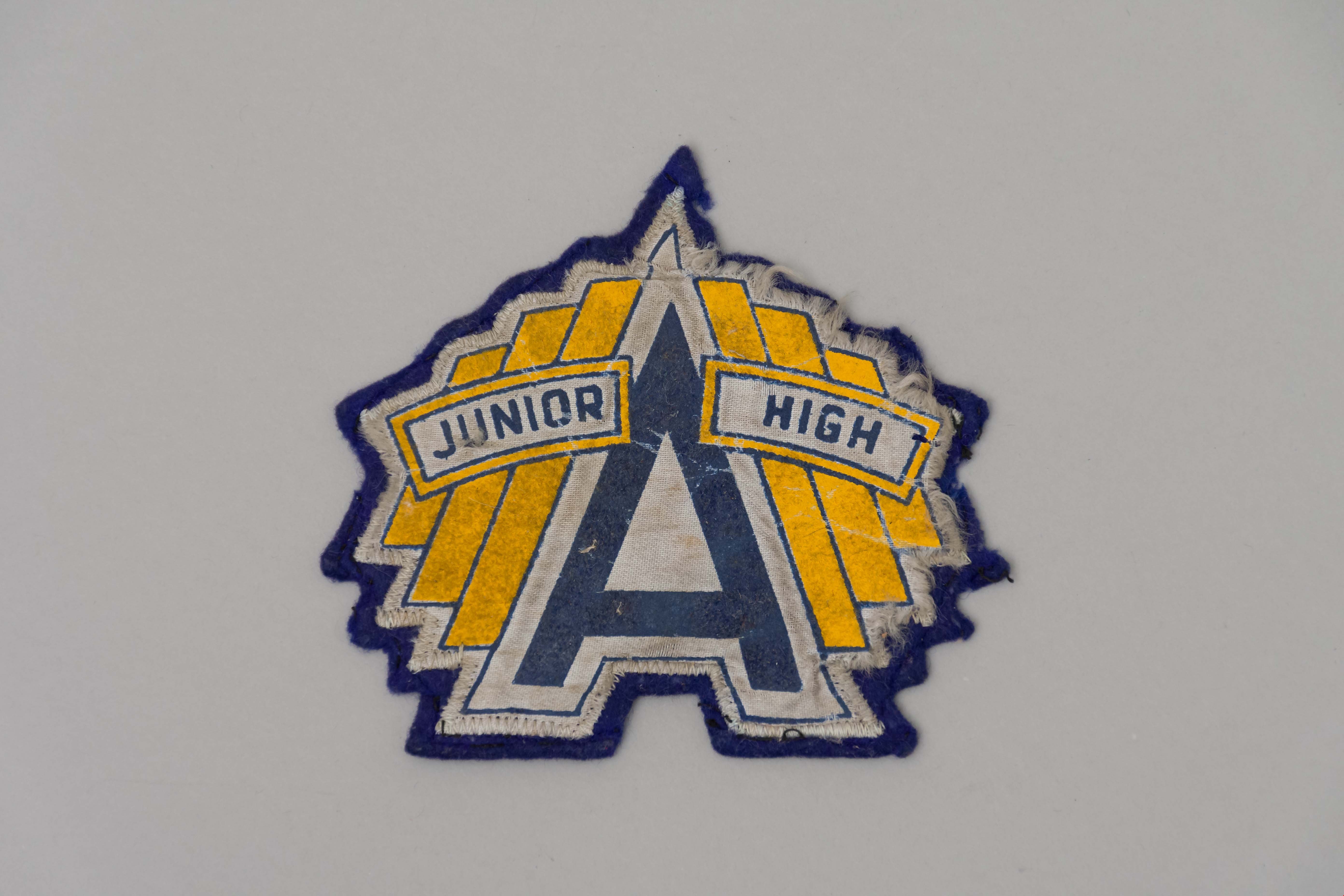
- A navy blue felt sew-on patch with the Alpha Junior High School logo. A large blue "A" is in the centre of the patch with a white outline. The words "Junior" and "High" are on either side of the "A" in blue with a yellow outline. Behind these two words are three yellow bars.
- Object History
- This patch belonged to the donor who attended Alpha Junior High School in the 1950s.
- Category
- 08. Communication Artifacts
- Classification
- Personal Symbols
- Object Term
- Patch, Insignia
- Marks/Labels
- A Junior High
- Colour
- Blue
- White
- Yellow
- Measurements
- 12 cm x 12cm
- Names
- Alpha Secondary School
- Historic Neighbourhood
- Capitol Hill (Historic Neighbourhood)
- Planning Study Area
- Parkcrest-Aubrey Area
Images