Narrow Results By
![Butler House at 8006 Government Road, [193-] thumbnail](/media/hpo/_Data/_BVM_Images/1983/198300420001.jpg?width=280)
Butler House at 8006 Government Road
https://search.heritageburnaby.ca/link/museumdescription281
- Repository
- Burnaby Village Museum
- Date
- [193-]
- Collection/Fonds
- Burnaby Village Museum Photograph collection
- Description Level
- Item
- Physical Description
- 1 photograph : b&w ; 6.1 x 8.6 cm
- Scope and Content
- Photograph of a house with wood plank boardwalk leading to the front door. On both sides of the planks are flower beds. The house is located at 8006 Government Road, Burnaby. Another house can be seen to the left of the photograph.
- Repository
- Burnaby Village Museum
- Collection/Fonds
- Burnaby Village Museum Photograph collection
- Description Level
- Item
- Physical Description
- 1 photograph : b&w ; 6.1 x 8.6 cm
- Scope and Content
- Photograph of a house with wood plank boardwalk leading to the front door. On both sides of the planks are flower beds. The house is located at 8006 Government Road, Burnaby. Another house can be seen to the left of the photograph.
- Subjects
- Buildings - Residential - Houses
- Geographic Access
- Government Road
- Street Address
- 8006 Government Road
- Accession Code
- HV983.42.1
- Access Restriction
- No restrictions
- Reproduction Restriction
- No known restrictions
- Date
- [193-]
- Media Type
- Photograph
- Historic Neighbourhood
- Lozells (Historic Neighbourhood)
- Planning Study Area
- Government Road Area
- Scan Resolution
- 600
- Scan Date
- 2023-09-12
- Notes
- Title based on contents of photograph
Images
![Butler House at 8006 Government Road, [193-] thumbnail](/media/hpo/_Data/_BVM_Images/1983/198300420001.jpg)
![Butler house yard, [193-] thumbnail](/media/hpo/_Data/_BVM_Images/1983/198300420002.jpg?width=280)
Butler house yard
https://search.heritageburnaby.ca/link/museumdescription282
- Repository
- Burnaby Village Museum
- Date
- [193-]
- Collection/Fonds
- Burnaby Village Museum Photograph collection
- Description Level
- Item
- Physical Description
- 1 photograph : b&w ; 6.3 x 9.0 cm
- Scope and Content
- Photograph of a family of three (a couple and a man or woman) at a table in the front yard of the house depicted in HV983.42.1. Visible to the right of the photograph is a flower bed that runs along the side of the wood plank boardwalk that leads to the front door. The house is located at 8006 Go…
- Repository
- Burnaby Village Museum
- Collection/Fonds
- Burnaby Village Museum Photograph collection
- Description Level
- Item
- Physical Description
- 1 photograph : b&w ; 6.3 x 9.0 cm
- Scope and Content
- Photograph of a family of three (a couple and a man or woman) at a table in the front yard of the house depicted in HV983.42.1. Visible to the right of the photograph is a flower bed that runs along the side of the wood plank boardwalk that leads to the front door. The house is located at 8006 Government Road, Burnaby. Another house can be seen to the left in the photograph.
- Subjects
- Buildings - Residential - Houses
- Geographic Access
- Government Road
- Street Address
- 8006 Government Road
- Accession Code
- HV983.42.2
- Access Restriction
- No restrictions
- Reproduction Restriction
- No known restrictions
- Date
- [193-]
- Media Type
- Photograph
- Historic Neighbourhood
- Lozells (Historic Neighbourhood)
- Planning Study Area
- Government Road Area
- Scan Resolution
- 600
- Scan Date
- 2023-09-12
- Notes
- Title based on contents of photograph
Images
![Butler house yard, [193-] thumbnail](/media/hpo/_Data/_BVM_Images/1983/198300420002.jpg)

date plaque
https://search.heritageburnaby.ca/link/museumartifact90987
- Repository
- Burnaby Village Museum
- Accession Code
- BV021.11.1
- Description
- Bronze date plaque stamped "F.V.M.P.A./ BURNABY PLANT SOD TURNING / JULY 26, 1962" with 4 corner holes. The object has scratches throughout. The plaque is taped to a cardboard tag with the text "B5102 / $0.80"
- Object History
- The plate is to commemorate the Fraser Valley Milk Producers Assocation Burnaby Plant sod turning ceremony on July 26, 1962, when construction started on the new facility at Sperling and Lougheed. The plant opened in 1964, and housed the FVMPA head offices, fluid milk plant, and ice cream manufacturing division.
- Category
- 08. Communication Artifacts
- Classification
- Documentary Artifacts - - Other Documents
- Object Term
- Plate, Identification
- Measurements
- 6.3cm wide x 3.1cm high
- Subjects
- Foods
- Agriculture
- Agriculture - Dairy
- Historic Neighbourhood
- Lozells (Historic Neighbourhood)
- Planning Study Area
- Government Road Area
Images

![Orville E. Butler at his house, [193-] thumbnail](/media/hpo/_Data/_BVM_Images/1983/198300420006.jpg?width=280)
Orville E. Butler at his house
https://search.heritageburnaby.ca/link/museumdescription285
- Repository
- Burnaby Village Museum
- Date
- [193-]
- Collection/Fonds
- Burnaby Village Museum Photograph collection
- Description Level
- Item
- Physical Description
- 1 photograph : b&w ; 20.0 x 25.2 cm
- Scope and Content
- Photograph of the Butler family house at 8006 Government Road. On the lawn, Orville E. Butler and a young woman with a hat, possibly his daughter, are sitting on a bench, looking towards the photographer.
- Repository
- Burnaby Village Museum
- Collection/Fonds
- Burnaby Village Museum Photograph collection
- Description Level
- Item
- Physical Description
- 1 photograph : b&w ; 20.0 x 25.2 cm
- Scope and Content
- Photograph of the Butler family house at 8006 Government Road. On the lawn, Orville E. Butler and a young woman with a hat, possibly his daughter, are sitting on a bench, looking towards the photographer.
- Subjects
- Buildings - Residential - Houses
- Names
- Butler, Orville E.
- Geographic Access
- Government Road
- Street Address
- 8006 Government Road
- Accession Code
- HV983.42.6
- Access Restriction
- No restrictions
- Reproduction Restriction
- No known restrictions
- Date
- [193-]
- Media Type
- Photograph
- Historic Neighbourhood
- Lozells (Historic Neighbourhood)
- Planning Study Area
- Government Road Area
- Scan Resolution
- 600
- Scan Date
- 2023-09-12
- Notes
- Title based on contents of photograph
- 1 smaller b&w photograph accompanying
Images
![Orville E. Butler at his house, [193-] thumbnail](/media/hpo/_Data/_BVM_Images/1983/198300420006.jpg)
![Orville E. Butler at his house, [193-] thumbnail](/media/hpo/_Data/_BVM_Images/1983/1983_0042_0007_a001.jpg?width=280)
Orville E. Butler at his house
https://search.heritageburnaby.ca/link/museumdescription286
- Repository
- Burnaby Village Museum
- Date
- [193-]
- Collection/Fonds
- Burnaby Village Museum Photograph collection
- Description Level
- Item
- Physical Description
- 1 photograph : b&w ; 17.5 x 22 cm
- Scope and Content
- Photograph of the Butler family house at 8006 Government Road. On the lawn, Mr. Orville E. Butler and a young woman with a hat, possibly his daughter, are sitting on a bench, looking towards the photographer.
- Repository
- Burnaby Village Museum
- Collection/Fonds
- Burnaby Village Museum Photograph collection
- Description Level
- Item
- Physical Description
- 1 photograph : b&w ; 17.5 x 22 cm
- Scope and Content
- Photograph of the Butler family house at 8006 Government Road. On the lawn, Mr. Orville E. Butler and a young woman with a hat, possibly his daughter, are sitting on a bench, looking towards the photographer.
- Subjects
- Buildings - Residential - Houses
- Names
- Butler, Orville E.
- Geographic Access
- Government Road
- Street Address
- 8006 Government Road
- Accession Code
- HV983.42.7
- Access Restriction
- No restrictions
- Reproduction Restriction
- No known restrictions
- Date
- [193-]
- Media Type
- Photograph
- Historic Neighbourhood
- Lozells (Historic Neighbourhood)
- Planning Study Area
- Government Road Area
- Scan Resolution
- 600
- Scan Date
- 2023-09-12
- Notes
- Title based on contents of photograph
Images
![Orville E. Butler at his house, [193-] thumbnail](/media/hpo/_Data/_BVM_Images/1983/1983_0042_0007_a001.jpg)
![Seaforth School, [1925] thumbnail](/media/hpo/_Data/_BVM_Images/1985/1985_6022_0001_001.jpg?width=280)
Seaforth School
https://search.heritageburnaby.ca/link/museumdescription1601
- Repository
- Burnaby Village Museum
- Date
- [1925]
- Collection/Fonds
- Burnaby Village Museum Photograph collection
- Description Level
- Item
- Physical Description
- 1 photograph : b&w ; 13.5 x 23.5 cm on paper 20 x 25.5 cm
- Scope and Content
- Photograph of Seaforth School at its original location on Government Road. Eighteen children are lined up along a wooden plank boardwalk at the front of the school. The school building was later moved to Burnaby Village Museum.
- Repository
- Burnaby Village Museum
- Collection/Fonds
- Burnaby Village Museum Photograph collection
- Description Level
- Item
- Physical Description
- 1 photograph : b&w ; 13.5 x 23.5 cm on paper 20 x 25.5 cm
- Scope and Content
- Photograph of Seaforth School at its original location on Government Road. Eighteen children are lined up along a wooden plank boardwalk at the front of the school. The school building was later moved to Burnaby Village Museum.
- Subjects
- Buildings - Schools
- Names
- Seaforth School
- Geographic Access
- Government Road
- Street Address
- 7881 Government Road
- Accession Code
- BV985.6022.1
- Access Restriction
- No restrictions
- Reproduction Restriction
- No known restrictions
- Date
- [1925]
- Media Type
- Photograph
- Historic Neighbourhood
- Lozells (Historic Neighbourhood)
- Planning Study Area
- Government Road Area
- Scan Resolution
- 600
- Scan Date
- 2024-03-05
- Notes
- Title based on contents of photograph
- Inscription in blue ballpoint pen on verso reads: "SEAFORTH SCHOOL C. 1925 BURNABY" and "mid-1920's/ SEAFORTH SCHOOL, BBY"
Images
![Seaforth School, [1925] thumbnail](/media/hpo/_Data/_BVM_Images/1985/1985_6022_0001_001.jpg)
![Seaforth School, [September 1925] thumbnail](/media/hpo/_Data/_BVM_Images/1985/1985_6022_0003_001.jpg?width=280)
Seaforth School
https://search.heritageburnaby.ca/link/museumdescription9714
- Repository
- Burnaby Village Museum
- Date
- [September 1925]
- Collection/Fonds
- Burnaby Village Museum Photograph collection
- Description Level
- Item
- Physical Description
- 1 photograph : b&w ; 16.0 x 10.7 cm print
- Scope and Content
- Photograph of a class of students at Seaforth School standing outside with their teacher and two dogs. Front row (all seated), left to right: Logan Wright, Doug (Douglas) Pipe, Jimmy (James) Haddon with Teddy the dog, Jack Wright, Roger the dog. Second row (all standing), left to right: Eva Carter,…
- Repository
- Burnaby Village Museum
- Collection/Fonds
- Burnaby Village Museum Photograph collection
- Description Level
- Item
- Physical Description
- 1 photograph : b&w ; 16.0 x 10.7 cm print
- Scope and Content
- Photograph of a class of students at Seaforth School standing outside with their teacher and two dogs. Front row (all seated), left to right: Logan Wright, Doug (Douglas) Pipe, Jimmy (James) Haddon with Teddy the dog, Jack Wright, Roger the dog. Second row (all standing), left to right: Eva Carter, Kathleen Pipe, June Muir, and Madeline R. Toebaert. Third row (all standing), left to right: Jack (John E.W.) Jenkins, Gordon K. Haddon, Lorne Muir, Evelyn E. Jenkins, Hazel Clarke, Beulah L. Toebaert. Back row, left to right: George J. Johnson, Russell Pipe, Miss Margaret B. Pullinger.
- Subjects
- Buildings - Schools
- Geographic Access
- Government Road
- Street Address
- 7881 Government Road
- Accession Code
- BV985.6022.3
- Access Restriction
- No restrictions
- Reproduction Restriction
- No known restrictions
- Date
- [September 1925]
- Media Type
- Photograph
- Historic Neighbourhood
- Lozells (Historic Neighbourhood)
- Planning Study Area
- Government Road Area
- Scan Resolution
- 600
- Scan Date
- 2024-03-05
- Notes
- Title based on contents of photograph
- Inscription in blue ballpoint pen on verso reads: "Seaforth School / Sept 1925".
Images
![Seaforth School, [September 1925] thumbnail](/media/hpo/_Data/_BVM_Images/1985/1985_6022_0003_001.jpg)
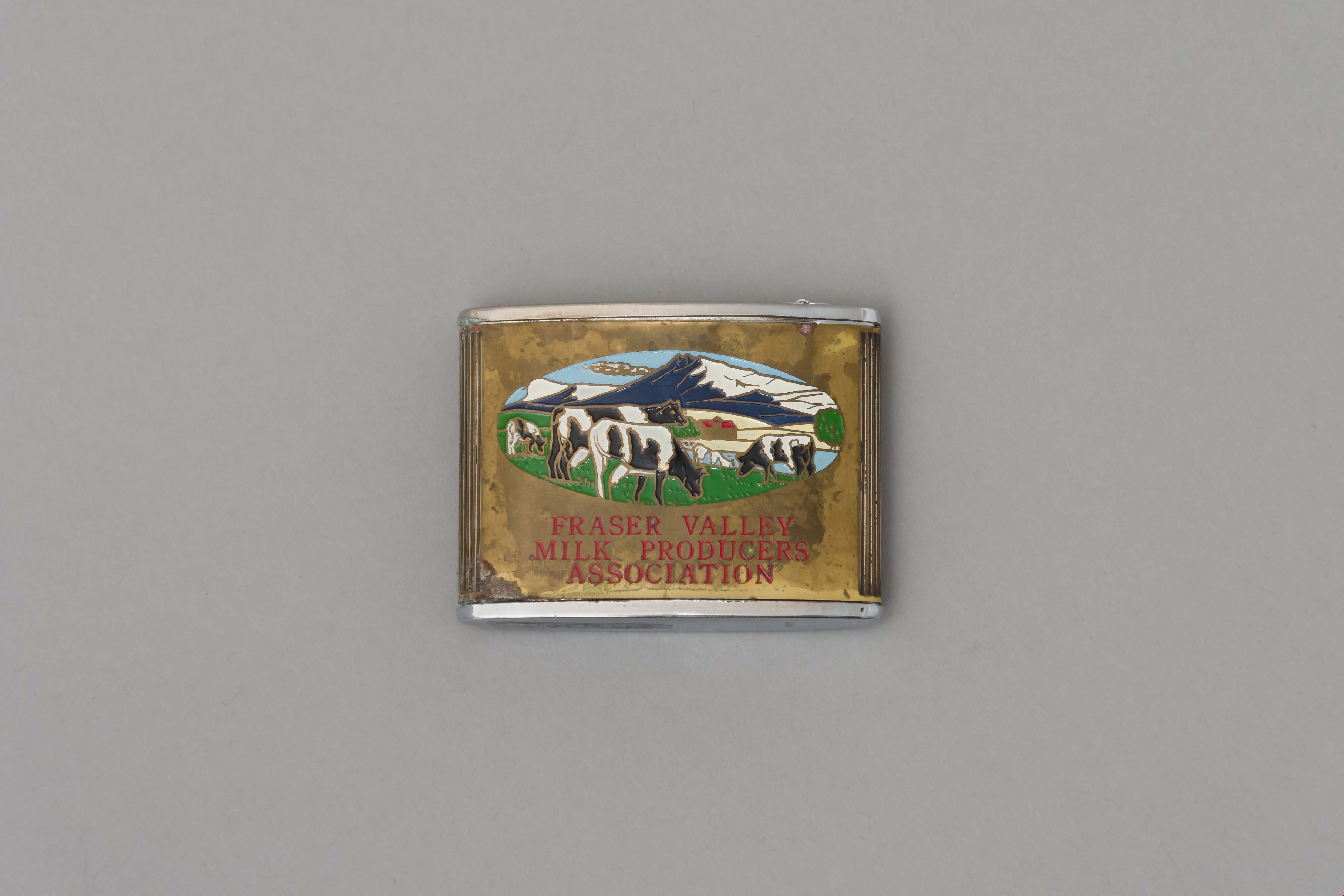
tape measure
https://search.heritageburnaby.ca/link/museumartifact90960
- Repository
- Burnaby Village Museum
- Accession Code
- BV021.10.1
- Description
- Promitional tape measurer with a silver top plates and a gold body engraved on both sides. One side dark blue with ariel drawing of building and "Dairyland/ BURNABY PLANT/ 1964" engraved. Reverse is oval image of 4 cows in a field with mountains, sky, and a barn painted on a gold body with "FRASER VALLEY/ MILK PRODUCERS/ ASSOCIATION" in red. Top has a retractable silver steel tape with measurements in inches on one side. "Japan" engraved on base.
- Object History
- This object belonged to a sales representative for Dairyland, who lived in Chilliwack. He retired in 1978 after 40 years with the company. The Burnaby Dairyland plant was constructed in 1964 on Lougheed Highway near Sperling Avenue.
- Reference
- http://www.bcdairyhistory.ca/milk-break/magazine/1964-fraser-valley-milk-break.pdf
- Classification
- Weights and Measurements Tools and Equipment - Scales
- Object Term
- Retractable Rule, Tape Measure
- Marks/Labels
- "Dairyland Burnaby Plant 1964", "Fraser Valley Milk Producers Association" "Japan"
- Measurements
- 4cm high x 5cm wide
- Subjects
- Foods
- Agriculture
- Agriculture - Dairy
- Historic Neighbourhood
- Lozells (Historic Neighbourhood)
- Planning Study Area
- Government Road Area
Images