Narrow Results By
Person / Organization
- A & H Plastering and Stucco 1
- Barnes, Hannah Victoria "Girlie" Love 1
- Beamish, Agnes 1
- Brandrith, Martha Dorothy “Dot” Love 2
- Burnaby Village Museum 1
- Butler, Edwin 1
- Chesters, Levi 1
- Derrick, Brenda 1
- Derrick, Ethel Beamish 1
- Feedham, Phoebe Leonard Love 1
- Feedham, William Charles 1
- Hawkshaw, Mabel Edith Honor McClean 1
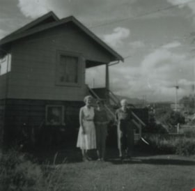
![335 16th Avenue, [between 1950 and 1954] (date of original), copied 1991 thumbnail](/media/hpo/_Data/_Archives_Images/_Unrestricted/370/370-430.jpg?width=280)
335 16th Avenue
https://search.heritageburnaby.ca/link/archivedescription37842
- Repository
- City of Burnaby Archives
- Date
- [between 1950 and 1954] (date of original), copied 1991
- Collection/Fonds
- Burnaby Historical Society fonds
- Description Level
- Item
- Physical Description
- 1 photograph : b&w ; 2.6 x 4.6 cm print on contact sheet 20.6 x 26.7 cm
- Scope and Content
- Photograph of 335 16th Avenue (later renumbered 8029 16th Avenue), the home of Mel and Lois Coutts from 1948 to 1955.
- Repository
- City of Burnaby Archives
- Date
- [between 1950 and 1954] (date of original), copied 1991
- Collection/Fonds
- Burnaby Historical Society fonds
- Subseries
- Burnaby Image Bank subseries
- Physical Description
- 1 photograph : b&w ; 2.6 x 4.6 cm print on contact sheet 20.6 x 26.7 cm
- Description Level
- Item
- Record No.
- 370-430
- Access Restriction
- No restrictions
- Reproduction Restriction
- No restrictions
- Accession Number
- BHS1999-03
- Scope and Content
- Photograph of 335 16th Avenue (later renumbered 8029 16th Avenue), the home of Mel and Lois Coutts from 1948 to 1955.
- Subjects
- Buildings - Residential - Houses
- Media Type
- Photograph
- Notes
- Title based on contents of photograph
- 1 b&w copy negative accompanying
- Negative has a pink cast
- Geographic Access
- 16th Avenue
- Street Address
- 8029 16th Avenue
- Historic Neighbourhood
- East Burnaby (Historic Neighbourhood)
- Planning Study Area
- Second Street Area
Images
![335 16th Avenue, [between 1950 and 1954] (date of original), copied 1991 thumbnail](/media/hpo/_Data/_Archives_Images/_Unrestricted/370/370-430.jpg)
![1796 1st Street, [1940] (date of original), copied 1991 thumbnail](/media/hpo/_Data/_Archives_Images/_Unrestricted/370/370-265.jpg?width=280)
1796 1st Street
https://search.heritageburnaby.ca/link/archivedescription37677
- Repository
- City of Burnaby Archives
- Date
- [1940] (date of original), copied 1991
- Collection/Fonds
- Burnaby Historical Society fonds
- Description Level
- Item
- Physical Description
- 1 photograph : b&w ; 3.9 x 2.3 cm print on contact sheet 20.2 x 25.3 cm
- Scope and Content
- Photograph of the back view of 1796 1st Street taken from a distance (later renumbered 7419 1st Street). The house was built before 1918.
- Repository
- City of Burnaby Archives
- Date
- [1940] (date of original), copied 1991
- Collection/Fonds
- Burnaby Historical Society fonds
- Subseries
- Burnaby Image Bank subseries
- Physical Description
- 1 photograph : b&w ; 3.9 x 2.3 cm print on contact sheet 20.2 x 25.3 cm
- Description Level
- Item
- Record No.
- 370-265
- Access Restriction
- No restrictions
- Reproduction Restriction
- No known restrictions
- Accession Number
- BHS1999-03
- Scope and Content
- Photograph of the back view of 1796 1st Street taken from a distance (later renumbered 7419 1st Street). The house was built before 1918.
- Subjects
- Buildings - Residential - Houses
- Media Type
- Photograph
- Notes
- Title based on contents of photograph
- 1 b&w copy negative accompanying
- Negative has a pink cast
- Geographic Access
- 1st Street
- Street Address
- 7149 1st Street
- Historic Neighbourhood
- East Burnaby (Historic Neighbourhood)
- Planning Study Area
- Second Street Area
Images
![1796 1st Street, [1940] (date of original), copied 1991 thumbnail](/media/hpo/_Data/_Archives_Images/_Unrestricted/370/370-265.jpg)
![1796 1st Street, [1940] (date of original), copied 1991 thumbnail](/media/hpo/_Data/_Archives_Images/_Unrestricted/370/370-266.jpg?width=280)
1796 1st Street
https://search.heritageburnaby.ca/link/archivedescription37678
- Repository
- City of Burnaby Archives
- Date
- [1940] (date of original), copied 1991
- Collection/Fonds
- Burnaby Historical Society fonds
- Description Level
- Item
- Physical Description
- 1 photograph : b&w ; 4.5 x 3.0 cm print on contact sheet 20.2 x 25.3 cm
- Scope and Content
- Photograph of the front view of 1796 1st Street (later renumbered 7149 1st Street). The house was built before 1918.
- Repository
- City of Burnaby Archives
- Date
- [1940] (date of original), copied 1991
- Collection/Fonds
- Burnaby Historical Society fonds
- Subseries
- Burnaby Image Bank subseries
- Physical Description
- 1 photograph : b&w ; 4.5 x 3.0 cm print on contact sheet 20.2 x 25.3 cm
- Description Level
- Item
- Record No.
- 370-266
- Access Restriction
- No restrictions
- Reproduction Restriction
- No known restrictions
- Accession Number
- BHS1999-03
- Scope and Content
- Photograph of the front view of 1796 1st Street (later renumbered 7149 1st Street). The house was built before 1918.
- Subjects
- Buildings - Residential - Houses
- Media Type
- Photograph
- Notes
- Title based on contents of photograph
- 1 b&w copy negative accompanying
- Negative has a pink cast
- Geographic Access
- 1st Street
- Street Address
- 7149 1st Street
- Historic Neighbourhood
- East Burnaby (Historic Neighbourhood)
- Planning Study Area
- Second Street Area
Images
![1796 1st Street, [1940] (date of original), copied 1991 thumbnail](/media/hpo/_Data/_Archives_Images/_Unrestricted/370/370-266.jpg)

6742 Walker Avenue
https://search.heritageburnaby.ca/link/archivedescription37864
- Repository
- City of Burnaby Archives
- Date
- 1990 (date of original), copied 1991
- Collection/Fonds
- Burnaby Historical Society fonds
- Description Level
- Item
- Physical Description
- 1 photograph : b&w ; 3.2 x 4.8 cm print on contact sheet 20.4 x 26.7 cm
- Scope and Content
- Photograph of 6742 Walker Avenue, taken in the summer of 1990.
- Repository
- City of Burnaby Archives
- Date
- 1990 (date of original), copied 1991
- Collection/Fonds
- Burnaby Historical Society fonds
- Subseries
- Burnaby Image Bank subseries
- Physical Description
- 1 photograph : b&w ; 3.2 x 4.8 cm print on contact sheet 20.4 x 26.7 cm
- Description Level
- Item
- Record No.
- 370-452
- Access Restriction
- No restrictions
- Reproduction Restriction
- No restrictions
- Accession Number
- BHS1999-03
- Scope and Content
- Photograph of 6742 Walker Avenue, taken in the summer of 1990.
- Subjects
- Buildings - Residential - Houses
- Media Type
- Photograph
- Notes
- Title based on contents of photograph
- 1 b&w copy negative accompanying
- Negative has a pink cast
- Copied from col. photograph
- Geographic Access
- Walker Avenue
- Street Address
- 6742 Walker Avenue
- Historic Neighbourhood
- East Burnaby (Historic Neighbourhood)
- Planning Study Area
- Richmond Park Area
Images

![Brookes family home, [1920] (date of original), copied 1986 thumbnail](/media/hpo/_Data/_Archives_Images/_Unrestricted/204/204-102.jpg?width=280)
Brookes family home
https://search.heritageburnaby.ca/link/archivedescription35245
- Repository
- City of Burnaby Archives
- Date
- [1920] (date of original), copied 1986
- Collection/Fonds
- Burnaby Historical Society fonds
- Description Level
- Item
- Physical Description
- 1 photograph : b&w ; 12.7 x 17.8 cm print
- Scope and Content
- Photograph of the Brookes family home at 441 12th Avenue (later renumbered 7979 12th Avenue), at the corner of 4th Street in East Burnaby. The Brookes family, headed by James Brookes, moved into this house in 1917. The house was later cut in two and moved to another part of the lot, becoming a gard…
- Repository
- City of Burnaby Archives
- Date
- [1920] (date of original), copied 1986
- Collection/Fonds
- Burnaby Historical Society fonds
- Subseries
- Pioneer Tales subseries
- Physical Description
- 1 photograph : b&w ; 12.7 x 17.8 cm print
- Description Level
- Item
- Record No.
- 204-102
- Access Restriction
- No restrictions
- Reproduction Restriction
- No known restrictions
- Accession Number
- BHS1988-03
- Scope and Content
- Photograph of the Brookes family home at 441 12th Avenue (later renumbered 7979 12th Avenue), at the corner of 4th Street in East Burnaby. The Brookes family, headed by James Brookes, moved into this house in 1917. The house was later cut in two and moved to another part of the lot, becoming a gardener's house in 1927 when "Normanna" was built. Note the greenhouse in front of the house. This house was built by Burnaby's first Reeve, Charles Shaw, and is now a designated heritage site at 7725 4th Street.
- Media Type
- Photograph
- Notes
- Title based on contents of photograph
- Geographic Access
- 4th Street
- Street Address
- 7725 4th Street
- Historic Neighbourhood
- East Burnaby (Historic Neighbourhood)
- Planning Study Area
- Second Street Area
Images
![Brookes family home, [1920] (date of original), copied 1986 thumbnail](/media/hpo/_Data/_Archives_Images/_Unrestricted/204/204-102.jpg)

Brookes family home, "Normanna"
https://search.heritageburnaby.ca/link/archivedescription35246
- Repository
- City of Burnaby Archives
- Date
- 1927
- Collection/Fonds
- Burnaby Historical Society fonds
- Description Level
- Item
- Physical Description
- 1 photograph : b&w ; 12.7 x 17.8 cm print
- Scope and Content
- Photograph of "Normanna," the Brookes family residence. This new Brookes family home was built in 1927 on the same site as the original house at 441 12th Avenue (later renumbered 7979 12th Avenue). Eventually, this became Normanna Norwegian rest home. The original house was built by Burnaby's firs…
- Repository
- City of Burnaby Archives
- Date
- 1927
- Collection/Fonds
- Burnaby Historical Society fonds
- Subseries
- Pioneer Tales subseries
- Physical Description
- 1 photograph : b&w ; 12.7 x 17.8 cm print
- Description Level
- Item
- Record No.
- 204-103
- Access Restriction
- No restrictions
- Reproduction Restriction
- No known restrictions
- Accession Number
- BHS1988-03
- Scope and Content
- Photograph of "Normanna," the Brookes family residence. This new Brookes family home was built in 1927 on the same site as the original house at 441 12th Avenue (later renumbered 7979 12th Avenue). Eventually, this became Normanna Norwegian rest home. The original house was built by Burnaby's first Reeve, Charles Shaw, and is now a designated heritage site at 7725 4th Street.
- Subjects
- Geographic Features - Gardens
- Buildings - Residential - Houses
- Buildings - Residential - Seniors Housing
- Buildings - Heritage
- Names
- Normanna Rest Home
- Media Type
- Photograph
- Notes
- Title based on contents of photograph
- Geographic Access
- 4th Street
- Street Address
- 7725 4th Street
- Historic Neighbourhood
- East Burnaby (Historic Neighbourhood)
- Planning Study Area
- Second Street Area
Images


Brook family home
https://search.heritageburnaby.ca/link/archivedescription34803
- Repository
- City of Burnaby Archives
- Date
- 1919
- Collection/Fonds
- Burnaby Historical Society fonds
- Description Level
- Item
- Physical Description
- 1 photograph : b&w ; 6.9 x 11.4 cm
- Scope and Content
- Photograph of the exterior of the Brook family home at 7979 12th Avenue, East Burnaby. This house later became the Normanna Rest Home, 7725 4th Street.
- Repository
- City of Burnaby Archives
- Date
- 1919
- Collection/Fonds
- Burnaby Historical Society fonds
- Subseries
- Kathleen Moore family subseries
- Physical Description
- 1 photograph : b&w ; 6.9 x 11.4 cm
- Description Level
- Item
- Record No.
- 135-001
- Access Restriction
- No restrictions
- Reproduction Restriction
- No known restrictions
- Accession Number
- BHS1985-03
- Scope and Content
- Photograph of the exterior of the Brook family home at 7979 12th Avenue, East Burnaby. This house later became the Normanna Rest Home, 7725 4th Street.
- Names
- Normanna Rest Home
- Media Type
- Photograph
- Photographer
- Moore, Godfrey
- Notes
- Title based on contents of photograph
- The accession register notes that the photos in the this collection were taken by Kathleen Moore's father
- Geographic Access
- 4th Street
- Street Address
- 7725 4th Street
- Historic Neighbourhood
- East Burnaby (Historic Neighbourhood)
- Planning Study Area
- Second Street Area
Images


building
https://search.heritageburnaby.ca/link/museumartifact3846
- Repository
- Burnaby Village Museum
- Accession Code
- BV988.33.1
- Description
- The core of the Jessie Love farm house is a 1893 two story, pioneer tent style building. The home was added to over the years and became a large Craftsmen style farm house.
- Object History
- Built on Cumberland Road in Burnaby in 1893. Music Room/Parlour/Living Room and bedrooms above added c.1898. Kitchen added c.1908. The home of Jesse and Martha Love and their eleven children. One of Burnaby's oldest structures. The home was moved to Burnaby Village Museum in the late 1980s and has been partially restored to its 1920s appearance.
- Category
- 01. Built Environment Objects
- Classification
- Structures - - Dwellings
- Object Term
- House
- Colour
- Brown
- Culture
- Canadian
- Geographic Access
- Cumberland Street
- Street Address
- 6501 Deer Lake Avenue
- Historic Neighbourhood
- East Burnaby (Historic Neighbourhood)
- Planning Study Area
- Cariboo-Armstrong Area
Images


Coldicutt House
https://search.heritageburnaby.ca/link/archivedescription34549
- Repository
- City of Burnaby Archives
- Date
- 1914
- Collection/Fonds
- Burnaby Historical Society fonds
- Description Level
- Item
- Physical Description
- 1 photograph : b&w ; 16.0 x 21.1 cm mounted on 25.1 x 30.1 cm cardboard
- Scope and Content
- Photograph of the exterior of the Coldicutt House at 7510 6th Street.
- Repository
- City of Burnaby Archives
- Date
- 1914
- Collection/Fonds
- Burnaby Historical Society fonds
- Subseries
- Photographs subseries
- Physical Description
- 1 photograph : b&w ; 16.0 x 21.1 cm mounted on 25.1 x 30.1 cm cardboard
- Description Level
- Item
- Record No.
- 044-009
- Access Restriction
- No restrictions
- Reproduction Restriction
- No known restrictions
- Accession Number
- BHS2007-04
- Scope and Content
- Photograph of the exterior of the Coldicutt House at 7510 6th Street.
- Media Type
- Photograph
- Notes
- Title based on contents of photograph
- Geographic Access
- 6th Street
- Street Address
- 7510 6th Street
- Historic Neighbourhood
- East Burnaby (Historic Neighbourhood)
- Planning Study Area
- Second Street Area
Images


Coldicutt house
https://search.heritageburnaby.ca/link/archivedescription36575
- Repository
- City of Burnaby Archives
- Date
- 1944
- Collection/Fonds
- Burnaby Historical Society fonds
- Description Level
- Item
- Physical Description
- 1 photograph : sepia ; 7 x 5 cm
- Scope and Content
- Photograph of the front of the Coldicutt House located at 6th Street and 16th Avenue.
- Repository
- City of Burnaby Archives
- Date
- 1944
- Collection/Fonds
- Burnaby Historical Society fonds
- Subseries
- Pixie McGeachie subseries
- Physical Description
- 1 photograph : sepia ; 7 x 5 cm
- Description Level
- Item
- Record No.
- 299-001
- Access Restriction
- No restrictions
- Reproduction Restriction
- No known restrictions
- Accession Number
- BHS1992-39
- Scope and Content
- Photograph of the front of the Coldicutt House located at 6th Street and 16th Avenue.
- Subjects
- Buildings - Residential - Houses
- Media Type
- Photograph
- Notes
- Title based on contents of photograph
- Geographic Access
- 6th Street
- Street Address
- 7510 6th Street
- Historic Neighbourhood
- East Burnaby (Historic Neighbourhood)
- Planning Study Area
- Second Street Area
Images

![Edwin Butler, [1925] (date of original), copied 1986 thumbnail](/media/hpo/_Data/_Archives_Images/_Unrestricted/204/204-204.jpg?width=280)
Edwin Butler
https://search.heritageburnaby.ca/link/archivedescription35347
- Repository
- City of Burnaby Archives
- Date
- [1925] (date of original), copied 1986
- Collection/Fonds
- Burnaby Historical Society fonds
- Description Level
- Item
- Physical Description
- 1 photograph : b&w ; 12.7 x 17.8 cm print
- Scope and Content
- Photograph of Edwin Butler with pet dog, Bing, and pet cat, Boots. Edwin was married to Margaret Butler. They first settled in Burnaby at 278 14th Avenue (later renumbered 8062 14th Avenue), East Burnaby in 1924.
- Repository
- City of Burnaby Archives
- Date
- [1925] (date of original), copied 1986
- Collection/Fonds
- Burnaby Historical Society fonds
- Subseries
- Pioneer Tales subseries
- Physical Description
- 1 photograph : b&w ; 12.7 x 17.8 cm print
- Description Level
- Item
- Record No.
- 204-204
- Access Restriction
- No restrictions
- Reproduction Restriction
- No known restrictions
- Accession Number
- BHS1988-03
- Scope and Content
- Photograph of Edwin Butler with pet dog, Bing, and pet cat, Boots. Edwin was married to Margaret Butler. They first settled in Burnaby at 278 14th Avenue (later renumbered 8062 14th Avenue), East Burnaby in 1924.
- Subjects
- Animals - Cats
- Animals - Dogs
- Names
- Butler, Edwin
- Media Type
- Photograph
- Notes
- Title based on contents of photograph
- Geographic Access
- 14th Avenue
- Street Address
- 8062 14th Avenue
- Historic Neighbourhood
- East Burnaby (Historic Neighbourhood)
- Planning Study Area
- Second Street Area
Images
![Edwin Butler, [1925] (date of original), copied 1986 thumbnail](/media/hpo/_Data/_Archives_Images/_Unrestricted/204/204-204.jpg)
![Ernest Street family home, [192-?] thumbnail](/media/hpo/_Data/_Archives_Images/_Unrestricted/205/217-001.jpg?width=280)
Ernest Street family home
https://search.heritageburnaby.ca/link/archivedescription36069
- Repository
- City of Burnaby Archives
- Date
- [192-?]
- Collection/Fonds
- Burnaby Historical Society fonds
- Description Level
- Item
- Physical Description
- 1 photograph ; sepia ; 7.5 x 13.5 cm
- Scope and Content
- Photograph of a person sitting in front of the home identified as the Ernest Street family home at 1205 Cumberland Street (old street numbering).
- Repository
- City of Burnaby Archives
- Date
- [192-?]
- Collection/Fonds
- Burnaby Historical Society fonds
- Subseries
- Helen Street subseries
- Physical Description
- 1 photograph ; sepia ; 7.5 x 13.5 cm
- Description Level
- Item
- Record No.
- 217-001
- Access Restriction
- No restrictions
- Reproduction Restriction
- No known restrictions
- Accession Number
- BHS1989-6
- Scope and Content
- Photograph of a person sitting in front of the home identified as the Ernest Street family home at 1205 Cumberland Street (old street numbering).
- Subjects
- Buildings - Residential - Houses
- Media Type
- Photograph
- Notes
- Title based on contents of photograph
- Geographic Access
- Cumberland Street
- Historic Neighbourhood
- East Burnaby (Historic Neighbourhood)
- Planning Study Area
- Cariboo-Armstrong Area
Images
![Ernest Street family home, [192-?] thumbnail](/media/hpo/_Data/_Archives_Images/_Unrestricted/205/217-001.jpg)
![Ernest Street family home, [194-?] thumbnail](/media/hpo/_Data/_Archives_Images/_Unrestricted/205/217-002.jpg?width=280)
Ernest Street family home
https://search.heritageburnaby.ca/link/archivedescription36070
- Repository
- City of Burnaby Archives
- Date
- [194-?]
- Collection/Fonds
- Burnaby Historical Society fonds
- Description Level
- Item
- Physical Description
- 1 photograph : col. ; 5.5 x 12 cm print
- Scope and Content
- Photograph of the Ernest Street home after it was altered.
- Repository
- City of Burnaby Archives
- Date
- [194-?]
- Collection/Fonds
- Burnaby Historical Society fonds
- Subseries
- Helen Street subseries
- Physical Description
- 1 photograph : col. ; 5.5 x 12 cm print
- Description Level
- Item
- Record No.
- 217-002
- Access Restriction
- No restrictions
- Reproduction Restriction
- Reproduce for fair dealing purposes only
- Accession Number
- BHS1989-6
- Scope and Content
- Photograph of the Ernest Street home after it was altered.
- Subjects
- Buildings - Residential - Houses
- Media Type
- Photograph
- Notes
- Title based on contents of photograph
- 1 col. copy negative accompanying
- Geographic Access
- Cumberland Street
- Historic Neighbourhood
- East Burnaby (Historic Neighbourhood)
- Planning Study Area
- Cariboo-Armstrong Area
Images
![Ernest Street family home, [194-?] thumbnail](/media/hpo/_Data/_Archives_Images/_Unrestricted/205/217-002.jpg)
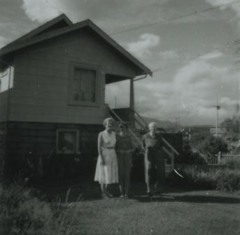
Ethel Derrick, Brenda Derrick and Agnes Beamish
https://search.heritageburnaby.ca/link/archivedescription37679
- Repository
- City of Burnaby Archives
- Date
- 1958 (date of original), copied 1991
- Collection/Fonds
- Burnaby Historical Society fonds
- Description Level
- Item
- Physical Description
- 1 photograph : b&w ; 3.7 x 3.7 cm print on contact sheet 20.2 x 25.3 cm
- Scope and Content
- Photograph of three generations; Ethel Beamish Derrick, her daughter Brenda Derrick and her mother Agnes Beamish, standing in front of the Beamish family home at 277 17th Avenue (later renumbered 8059 17th Avenue).
- Repository
- City of Burnaby Archives
- Date
- 1958 (date of original), copied 1991
- Collection/Fonds
- Burnaby Historical Society fonds
- Subseries
- Burnaby Image Bank subseries
- Physical Description
- 1 photograph : b&w ; 3.7 x 3.7 cm print on contact sheet 20.2 x 25.3 cm
- Description Level
- Item
- Record No.
- 370-267
- Access Restriction
- No restrictions
- Reproduction Restriction
- No restrictions
- Accession Number
- BHS1999-03
- Scope and Content
- Photograph of three generations; Ethel Beamish Derrick, her daughter Brenda Derrick and her mother Agnes Beamish, standing in front of the Beamish family home at 277 17th Avenue (later renumbered 8059 17th Avenue).
- Subjects
- Buildings - Residential - Houses
- Media Type
- Photograph
- Notes
- Title based on contents of photograph
- 1 b&w copy negative accompanying
- Geographic Access
- 17th Avenue
- Street Address
- 8059 17th Avenue
- Historic Neighbourhood
- East Burnaby (Historic Neighbourhood)
- Planning Study Area
- Second Street Area
Images

Exterior of Love farmhouse
https://search.heritageburnaby.ca/link/museumdescription1129
- Repository
- Burnaby Village Museum
- Date
- 1971 (date of original), copied 1990
- Collection/Fonds
- Love family fonds
- Description Level
- Item
- Physical Description
- 1 photograph : col. ; 10 x 15 cm print
- Scope and Content
- Photograph of the northern exterior of the Love farmhouse while Elsie (nee Love) Hughes, her husband John and son Brent lived in the house. The one storey section housed the kitchen which was added in 1903 to the original house which was built in 1893. The house is located at 7651 Cumberland Stree…
- Repository
- Burnaby Village Museum
- Collection/Fonds
- Love family fonds
- Description Level
- Item
- Physical Description
- 1 photograph : col. ; 10 x 15 cm print
- Material Details
- Copy print was made from re-photographing an original colour slide
- Scope and Content
- Photograph of the northern exterior of the Love farmhouse while Elsie (nee Love) Hughes, her husband John and son Brent lived in the house. The one storey section housed the kitchen which was added in 1903 to the original house which was built in 1893. The house is located at 7651 Cumberland Street (Address pre 1960: 1390 Cumberland Road) and was moved from its original site to the Burnaby Village Museum in 1988 and designated a Municipal Heritage Landmark in 1992.
- Geographic Access
- Cumberland Street
- Street Address
- 7651 Cumberland Street
- Accession Code
- BV992.15.10
- Access Restriction
- Restricted access
- Reproduction Restriction
- May be restricted by third party rights
- Date
- 1971 (date of original), copied 1990
- Media Type
- Photograph
- Historic Neighbourhood
- East Burnaby (Historic Neighbourhood)
- Planning Study Area
- Cariboo-Armstrong Area
- Scan Resolution
- 600
- Scan Date
- 01-Jun-09
- Scale
- 100
- Photographer
- Parker, Albert "Bert"
- Notes
- Title based on contents of photograph
Images


Exterior of Love farmhouse
https://search.heritageburnaby.ca/link/museumdescription1130
- Repository
- Burnaby Village Museum
- Date
- 1971 (date of original), copied 1990
- Collection/Fonds
- Love family fonds
- Description Level
- Item
- Physical Description
- 1 photograph : col. ; 10 x 15 cm print
- Scope and Content
- Photograph of the exterior of the west side of the Love farnhouse while Elsie (nee Love) Hughes, her husband John and son Brent lived in the house.The one storey section housed the kitchen which was attached to the main house in 1903. The house was located at 7651 Cumberland Street (Address pre 196…
- Repository
- Burnaby Village Museum
- Collection/Fonds
- Love family fonds
- Description Level
- Item
- Physical Description
- 1 photograph : col. ; 10 x 15 cm print
- Material Details
- Copy print was made from re-photographing an original colour slide
- Scope and Content
- Photograph of the exterior of the west side of the Love farnhouse while Elsie (nee Love) Hughes, her husband John and son Brent lived in the house.The one storey section housed the kitchen which was attached to the main house in 1903. The house was located at 7651 Cumberland Street (Address pre 1960: 1390 Cumberland Road) and was moved from its original site to the Burnaby Village Museum in 1988 and designated a Municipal Heritage Landmark in 1992.
- Geographic Access
- Cumberland Street
- Street Address
- 7651 Cumberland Street
- Accession Code
- BV992.15.11
- Access Restriction
- Restricted access
- Reproduction Restriction
- May be restricted by third party rights
- Date
- 1971 (date of original), copied 1990
- Media Type
- Photograph
- Historic Neighbourhood
- East Burnaby (Historic Neighbourhood)
- Planning Study Area
- Cariboo-Armstrong Area
- Scan Resolution
- 600
- Scan Date
- 01-Jun-09
- Scale
- 100
- Photographer
- Parker, Albert "Bert"
- Notes
- Title based on contents of photograph
Images


Exterior of Love farmhouse
https://search.heritageburnaby.ca/link/museumdescription1131
- Repository
- Burnaby Village Museum
- Date
- 1971 (date of original), copied 1990
- Collection/Fonds
- Love family fonds
- Description Level
- Item
- Physical Description
- 1 photograph : col. ; 10 x 15 cm print
- Scope and Content
- Photograph of the exterior of the Love farmhouse taken from the corner of Fourteenth Avenue and Cumberland Street while Elsie (nee Love) Hughes, her husband John and son Brent lived in the house. The house was located at 7651 Cumberland Street (Address pre 1960: 1390 Cumberland Road) and was moved …
- Repository
- Burnaby Village Museum
- Collection/Fonds
- Love family fonds
- Description Level
- Item
- Physical Description
- 1 photograph : col. ; 10 x 15 cm print
- Material Details
- Copy print was made from re-photographing an original colour slide
- Scope and Content
- Photograph of the exterior of the Love farmhouse taken from the corner of Fourteenth Avenue and Cumberland Street while Elsie (nee Love) Hughes, her husband John and son Brent lived in the house. The house was located at 7651 Cumberland Street (Address pre 1960: 1390 Cumberland Road) and was moved from its original site to the Burnaby Village Museum in 1988 and designated a Municipal Heritage Landmark in 1992.
- Geographic Access
- Cumberland Street
- 14th Avenue
- Street Address
- 7651 Cumberland Street
- Accession Code
- BV992.15.12
- Access Restriction
- Restricted access
- Reproduction Restriction
- May be restricted by third party rights
- Date
- 1971 (date of original), copied 1990
- Media Type
- Photograph
- Historic Neighbourhood
- East Burnaby (Historic Neighbourhood)
- Planning Study Area
- Cariboo-Armstrong Area
- Scan Resolution
- 600
- Scan Date
- 01-Jun-09
- Scale
- 100
- Photographer
- Parker, Albert "Bert"
- Notes
- Title based on contents of photograph
Images

![First house on Twelfth Avenue, [194-?] (date of original), copied 1991 thumbnail](/media/hpo/_Data/_Archives_Images/_Unrestricted/370/370-782.jpg?width=280)
First house on Twelfth Avenue
https://search.heritageburnaby.ca/link/archivedescription38195
- Repository
- City of Burnaby Archives
- Date
- [194-?] (date of original), copied 1991
- Collection/Fonds
- Burnaby Historical Society fonds
- Description Level
- Item
- Physical Description
- 1 photograph : b&w ; 3.3 x 5.1 cm print on contact sheet 20.3 x 26.6 cm
- Scope and Content
- Photograph of the first house on 12th Avenue, at 160 12th Avenue (later renumbered 8142 12th Avenue).
- Repository
- City of Burnaby Archives
- Date
- [194-?] (date of original), copied 1991
- Collection/Fonds
- Burnaby Historical Society fonds
- Subseries
- Burnaby Image Bank subseries
- Physical Description
- 1 photograph : b&w ; 3.3 x 5.1 cm print on contact sheet 20.3 x 26.6 cm
- Description Level
- Item
- Record No.
- 370-782
- Access Restriction
- No restrictions
- Reproduction Restriction
- Reproduce for fair dealing purposes only
- Accession Number
- BHS1999-03
- Scope and Content
- Photograph of the first house on 12th Avenue, at 160 12th Avenue (later renumbered 8142 12th Avenue).
- Subjects
- Buildings - Residential - Houses
- Media Type
- Photograph
- Notes
- Title based on contents of photograph
- 1 b&w copy negative accompanying
- Geographic Access
- 12th Avenue
- Street Address
- 8142 12th Avenue
- Historic Neighbourhood
- East Burnaby (Historic Neighbourhood)
- Planning Study Area
- Second Street Area
Images
![First house on Twelfth Avenue, [194-?] (date of original), copied 1991 thumbnail](/media/hpo/_Data/_Archives_Images/_Unrestricted/370/370-782.jpg)
![Floden House, [2001] thumbnail](/media/hpo/_Data/_Archives_Images/_Unrestricted/535/535-1543.jpg?width=280)
Floden House
https://search.heritageburnaby.ca/link/archivedescription95680
- Repository
- City of Burnaby Archives
- Date
- [2001]
- Collection/Fonds
- Burnaby NewsLeader photograph collection
- Description Level
- Item
- Physical Description
- 1 photograph (tiff) : col.
- Scope and Content
- Photograph of Rolf Floden standing in front of Floden House on 18th Ave, prior to its heritage designation and its relocation by the City of Burnaby to 4th Avenue.
- Repository
- City of Burnaby Archives
- Date
- [2001]
- Collection/Fonds
- Burnaby NewsLeader photograph collection
- Physical Description
- 1 photograph (tiff) : col.
- Description Level
- Item
- Record No.
- 535-1543
- Access Restriction
- No restrictions
- Reproduction Restriction
- No restrictions
- Accession Number
- 2018-12
- Scope and Content
- Photograph of Rolf Floden standing in front of Floden House on 18th Ave, prior to its heritage designation and its relocation by the City of Burnaby to 4th Avenue.
- Media Type
- Photograph
- Photographer
- Bartel, Mario
- Notes
- Title based on caption
- Collected by editorial for use in a January 2001 issue of the Burnaby NewsLeader
- Caption from metadata: "Rolf Floden visits the house on 18th Ave. where he grew up. The house has been purchased by the city of Burnaby and will be moved to another site to be preserved."
- Geographic Access
- 18th Avenue
- Street Address
- 7244 4th Street
- Historic Neighbourhood
- East Burnaby (Historic Neighbourhood)
- Planning Study Area
- Edmonds Area
Images
![Floden House, [2001] thumbnail](/media/hpo/_Data/_Archives_Images/_Unrestricted/535/535-1543.jpg)
![Floden House auction, [2003] thumbnail](/media/hpo/_Data/_Archives_Images/_Unrestricted/535/535-1827.jpg?width=280)
Floden House auction
https://search.heritageburnaby.ca/link/archivedescription96127
- Repository
- City of Burnaby Archives
- Date
- [2003]
- Collection/Fonds
- Burnaby NewsLeader photograph collection
- Description Level
- Item
- Physical Description
- 1 photograph (tiff) : col.
- Scope and Content
- Photograph of Helen Krenzler, City of Burnaby property negotiator, standing in front of the heritage home Floden House and a sign that reads: "City of Burnaby / For Sale by Public Tender / Viewing by Appointment / Minimum Bid Price $295,000.00". Krenzler holds a banker's box that contains an antiqu…
- Repository
- City of Burnaby Archives
- Date
- [2003]
- Collection/Fonds
- Burnaby NewsLeader photograph collection
- Physical Description
- 1 photograph (tiff) : col.
- Description Level
- Item
- Record No.
- 535-1827
- Access Restriction
- No restrictions
- Reproduction Restriction
- No restrictions
- Accession Number
- 2018-12
- Scope and Content
- Photograph of Helen Krenzler, City of Burnaby property negotiator, standing in front of the heritage home Floden House and a sign that reads: "City of Burnaby / For Sale by Public Tender / Viewing by Appointment / Minimum Bid Price $295,000.00". Krenzler holds a banker's box that contains an antique light fixture.
- Media Type
- Photograph
- Photographer
- Bartel, Mario
- Notes
- Title based on caption
- Collected by editorial for use in a January 2003 issue of the Burnaby NewsLeader
- Caption from metadata: "Helen Krenzler, the City of Burnaby's property negotiator, returns some antique light fixtures to the old Floden House, in preparation for an open house for prospective buyers. The City is auctioning the heritage home after moving it to a new location last year."
- Geographic Access
- 4th Street
- Street Address
- 7244 4th Street
- Historic Neighbourhood
- East Burnaby (Historic Neighbourhood)
- Planning Study Area
- Edmonds Area
Images
![Floden House auction, [2003] thumbnail](/media/hpo/_Data/_Archives_Images/_Unrestricted/535/535-1827.jpg)