Narrow Results By
Subject
- Advertising Medium - Flyer 1
- Advertising Medium - Signs and Signboards 1
- Agriculture 2
- Agriculture - Farms 3
- Agriculture - Ranches 1
- Animals - Birds
- Animals - Dogs 1
- Animals - Pigs 1
- Buildings - Civic - Archives 1
- Buildings - Civic - City Halls 1
- Buildings - Commercial - Department Stores 1
- Buildings - Commercial - Restaurants 1
![6664 Deer Lake Avenue lake frontage, [1979] thumbnail](/media/hpo/_Data/_Archives_Images/_Unrestricted/600/625-034.jpg?width=280)
6664 Deer Lake Avenue lake frontage
https://search.heritageburnaby.ca/link/archivedescription95606
- Repository
- City of Burnaby Archives
- Date
- [1979]
- Collection/Fonds
- City of Burnaby Archives photograph collection
- Description Level
- Item
- Physical Description
- 1 photograph (tiff)
- Scope and Content
- Photograph of the lake frontage at 6664 Deer Lake Avenue (formerly the F.J. Hart Estate "Avalon"; now Hart House). This photograph was taken prior to the City of Burnaby’s purchase of the home in 1979. Canada geese sit on a grassy lawn beneath trees on the edge of Deer Lake.
- Repository
- City of Burnaby Archives
- Date
- [1979]
- Collection/Fonds
- City of Burnaby Archives photograph collection
- Physical Description
- 1 photograph (tiff)
- Description Level
- Item
- Record No.
- 625-034
- Access Restriction
- No restrictions
- Reproduction Restriction
- Reproduce for fair dealing purposes only
- Accession Number
- 2021-10
- Scope and Content
- Photograph of the lake frontage at 6664 Deer Lake Avenue (formerly the F.J. Hart Estate "Avalon"; now Hart House). This photograph was taken prior to the City of Burnaby’s purchase of the home in 1979. Canada geese sit on a grassy lawn beneath trees on the edge of Deer Lake.
- Subjects
- Buildings - Heritage
- Animals - Birds
- Media Type
- Photograph
- Notes
- Title based on caption
- Caption was added during digitization.
- Geographic Access
- Deer Lake
- Street Address
- 6664 Deer Lake Avenue
- Historic Neighbourhood
- Burnaby Lake (Historic Neighbourhood)
- Planning Study Area
- Morley-Buckingham Area
Images
![6664 Deer Lake Avenue lake frontage, [1979] thumbnail](/media/hpo/_Data/_Archives_Images/_Unrestricted/600/625-034.jpg)
map
https://search.heritageburnaby.ca/link/museumartifact87474
- Repository
- Burnaby Village Museum
- Accession Code
- BV015.35.83
- Description
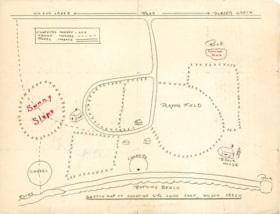
- map; "SKETCH MAP OF CANADIAN GIRL GUIDE CAMP, WILSON CREEK"; hand-drawn map shows locations of campsites, trails, roads, bathing beach, chapel, playing field, etc.; back of map has text in brown ink reading: "Over the hill and / down the valley" and Over the ill & do"
- Object History
- Map belonged to Dorothy Pitman who was a Girl Guide in the 1st Burnaby Company. She was known to be involved with guiding from 1919 to 1931. Textual records and photographs of the Pitman family, including one of Dorothy and her sister Gwen, are held by the City of Burnaby Archives. Dorothy and Gwen's parents, Ernest and Jean Pitman, owned McKay Dry Goods and Jubilee Dry Goods.
- Category
- 08. Communication Artifacts
- Classification
- Documentary Artifacts - - Graphic Documents
- Object Term
- Cartograph, Map
Images