Narrow Results By
7641-7651 Royal Oak Ave
https://search.heritageburnaby.ca/link/archivedescription93769
- Repository
- City of Burnaby Archives
- Date
- July 30, 1992
- Collection/Fonds
- Grover, Elliott & Co. Ltd. fonds
- Description Level
- File
- Physical Description
- 25 photographs : col. negatives ; 35 mm
- Scope and Content
- Photographs of the commercial properties located between 7641 and 7651 Royal Oak Avenue. Stores visible in the photographs include: Buy Low Foods, Mega Movies, and Chevron service station.
- Repository
- City of Burnaby Archives
- Date
- July 30, 1992
- Collection/Fonds
- Grover, Elliott & Co. Ltd. fonds
- Physical Description
- 25 photographs : col. negatives ; 35 mm
- Description Level
- File
- Record No.
- 622-053
- Access Restriction
- No restrictions
- Reproduction Restriction
- No restrictions
- Accession Number
- 2017-39
- Scope and Content
- Photographs of the commercial properties located between 7641 and 7651 Royal Oak Avenue. Stores visible in the photographs include: Buy Low Foods, Mega Movies, and Chevron service station.
- Subjects
- Buildings - Commercial
- Buildings - Commercial - Service Stations
- Buildings - Commercial - Stores
- Geographic Features - Roads
- Media Type
- Photograph
- Photographer
- Young, Richard
- Notes
- Transcribed title
- Title transcribed from envelope photographs were originally housed in
- File no. 92-287-B
- Geographic Access
- Royal Oak Avenue
- Historic Neighbourhood
- Alta Vista (Historic Neighbourhood)
- Planning Study Area
- Maywood Area
Crossing Royal Oak & Rumble Street
https://search.heritageburnaby.ca/link/archivedescription93686
- Repository
- City of Burnaby Archives
- Date
- May 19, 1978
- Collection/Fonds
- Burnaby Public Library Contemporary Visual Archive Project
- Description Level
- Item
- Physical Description
- 1 photograph : b&w ; 12.5 x 17.5 cm
- Scope and Content
- Photograph of the intersection of Royal Oak Avenue and Rumble Street. Cars and pedestrians are crossing the intersection, and the signs for businesses TD Bank, Standard Oil/Chevron gas station, Gulf gas station, and Baxter's Market are visible. The photograph is taken from a corner of the intersect…
- Repository
- City of Burnaby Archives
- Date
- May 19, 1978
- Collection/Fonds
- Burnaby Public Library Contemporary Visual Archive Project
- Physical Description
- 1 photograph : b&w ; 12.5 x 17.5 cm
- Description Level
- Item
- Record No.
- 556-643
- Access Restriction
- No restrictions
- Reproduction Restriction
- Reproduce for fair dealing purposes only
- Accession Number
- 2017-57
- Scope and Content
- Photograph of the intersection of Royal Oak Avenue and Rumble Street. Cars and pedestrians are crossing the intersection, and the signs for businesses TD Bank, Standard Oil/Chevron gas station, Gulf gas station, and Baxter's Market are visible. The photograph is taken from a corner of the intersection, facing southeast.
- Subjects
- Geographic Features - Roads
- Advertising Medium - Signs and Signboards
- Buildings - Commercial - Service Stations
- Transportation - Automobiles
- Buildings - Commercial
- Media Type
- Photograph
- Photographer
- van Mannen, Mark
- Notes
- Title taken from project information form
- Accompanied by a project information form and 1 photograph (b&w negative ; 9.5 x 12.5 cm)
- BPL no. 91
- Geographic Access
- Royal Oak Avenue
- Rumble Street
- Historic Neighbourhood
- Alta Vista (Historic Neighbourhood)
- Planning Study Area
- Sussex-Nelson Area
Images
Crossing Royal Oak & Rumble Street
https://search.heritageburnaby.ca/link/archivedescription93687
- Repository
- City of Burnaby Archives
- Date
- May 19, 1978
- Collection/Fonds
- Burnaby Public Library Contemporary Visual Archive Project
- Description Level
- Item
- Physical Description
- 1 photograph : b&w ; 12.5 x 17.5 cm
- Scope and Content
- Photograph of the intersection of Royal Oak Avenue and Rumble Street. Cars and pedestrians are crossing the intersection, and the signs for businesses Grace United Pharmacy, Standard Oil/Chevron gas station, Gulf gas station, and Royal Meats are visible. The photograph is taken from the Gulf gas st…
- Repository
- City of Burnaby Archives
- Date
- May 19, 1978
- Collection/Fonds
- Burnaby Public Library Contemporary Visual Archive Project
- Physical Description
- 1 photograph : b&w ; 12.5 x 17.5 cm
- Description Level
- Item
- Record No.
- 556-644
- Access Restriction
- No restrictions
- Reproduction Restriction
- Reproduce for fair dealing purposes only
- Accession Number
- 2017-57
- Scope and Content
- Photograph of the intersection of Royal Oak Avenue and Rumble Street. Cars and pedestrians are crossing the intersection, and the signs for businesses Grace United Pharmacy, Standard Oil/Chevron gas station, Gulf gas station, and Royal Meats are visible. The photograph is taken from the Gulf gas station parking lot, facing northwest.
- Subjects
- Advertising Medium - Signs and Signboards
- Geographic Features - Roads
- Transportation - Automobiles
- Buildings - Commercial
- Buildings - Commercial - Service Stations
- Media Type
- Photograph
- Photographer
- van Mannen, Mark
- Notes
- Title taken from project information form
- Accompanied by a project information form and 1 photograph (b&w negative ; 9.5 x 12.5 cm)
- BPL no. 92
- Geographic Access
- Royal Oak Avenue
- Rumble Street
- Historic Neighbourhood
- Alta Vista (Historic Neighbourhood)
- Planning Study Area
- Sussex-Nelson Area
Images
Diana Mumford at school crossing
https://search.heritageburnaby.ca/link/archivedescription97528
- Repository
- City of Burnaby Archives
- Date
- [2000]
- Collection/Fonds
- Burnaby NewsLeader photograph collection
- Description Level
- Item
- Physical Description
- 1 photograph (tiff) : col.
- Scope and Content
- Photograph of Diana Mumford standing on the shoulder of Rumble Street beside a school zone sign, in front of the Suncrest Elementary fences.
- Repository
- City of Burnaby Archives
- Date
- [2000]
- Collection/Fonds
- Burnaby NewsLeader photograph collection
- Physical Description
- 1 photograph (tiff) : col.
- Description Level
- Item
- Record No.
- 535-2867
- Access Restriction
- No restrictions
- Reproduction Restriction
- No restrictions
- Accession Number
- 2018-12
- Scope and Content
- Photograph of Diana Mumford standing on the shoulder of Rumble Street beside a school zone sign, in front of the Suncrest Elementary fences.
- Media Type
- Photograph
- Photographer
- Bartel, Mario
- Notes
- Title based on caption
- Collected by editorial for use in an October 2000 issue of the Burnaby NewsLeader
- Caption from metadata: "Diana Mumford is upset at the lack of sidewalks and safe bus stops along Rumble St. The north side of the street at Suncrest Elementary has speed zone signs, but no sidewalks along which children can safely walk to the school."
- Geographic Access
- Rumble Street
- Street Address
- 3883 Rumble Street
- Historic Neighbourhood
- Alta Vista (Historic Neighbourhood)
- Planning Study Area
- Suncrest Area
Images
Jubilee Avenue
https://search.heritageburnaby.ca/link/museumdescription1699
- Repository
- Burnaby Village Museum
- Date
- May 1955
- Collection/Fonds
- Burnaby Village Museum Photograph collection
- Description Level
- Item
- Physical Description
- 1 photograph : b&w ; 7.5 x 7.5 cm
- Scope and Content
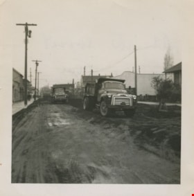
- Photograph of a section of Jubilee Avenue; the entire span of the paved road has been dug up and two trucks are visible driving over the muddy ground.
- Repository
- Burnaby Village Museum
- Collection/Fonds
- Burnaby Village Museum Photograph collection
- Description Level
- Item
- Physical Description
- 1 photograph : b&w ; 7.5 x 7.5 cm
- Scope and Content
- Photograph of a section of Jubilee Avenue; the entire span of the paved road has been dug up and two trucks are visible driving over the muddy ground.
- Geographic Access
- Jubilee Avenue
- Accession Code
- BV004.7.5
- Access Restriction
- Restricted access
- Reproduction Restriction
- May be restricted by third party rights
- Date
- May 1955
- Media Type
- Photograph
- Historic Neighbourhood
- Alta-Vista (Historic Neighbourhood)
- Planning Study Area
- Sussex-Nelson Area
- Related Material
- For another photograph of roadwork scene at Jubilee Avenue, see BV004.7.6
- Scan Resolution
- 600
- Scan Date
- 09-Jun-09
- Scale
- 100
- Notes
- Title based on contents of photograph
- Note in blue ink on verso of photograph reads: "Jubilee Ave/ May 1955"
Images
Jubilee Avenue
https://search.heritageburnaby.ca/link/museumdescription1700
- Repository
- Burnaby Village Museum
- Date
- May 1955
- Collection/Fonds
- Burnaby Village Museum Photograph collection
- Description Level
- Item
- Physical Description
- 1 photograph : b&w ; 7.5 x 7.5 cm
- Scope and Content
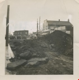
- Photograph of a section of Jubilee Avenue; the entire span of the paved road has been dug up and a line of dump trucks are driving over the muddy ground in the distance.
- Repository
- Burnaby Village Museum
- Collection/Fonds
- Burnaby Village Museum Photograph collection
- Description Level
- Item
- Physical Description
- 1 photograph : b&w ; 7.5 x 7.5 cm
- Scope and Content
- Photograph of a section of Jubilee Avenue; the entire span of the paved road has been dug up and a line of dump trucks are driving over the muddy ground in the distance.
- Geographic Access
- Jubilee Avenue
- Accession Code
- BV004.7.6
- Access Restriction
- Restricted access
- Reproduction Restriction
- May be restricted by third party rights
- Date
- May 1955
- Media Type
- Photograph
- Historic Neighbourhood
- Alta-Vista (Historic Neighbourhood)
- Planning Study Area
- Sussex-Nelson Area
- Related Material
- For another photograph of roadwork scene at Jubilee Avenue, see BV004.7.5
- Scan Resolution
- 600
- Scan Date
- 09-Jun-09
- Notes
- Title based on contents of photograph
- Note in blue ink on verso of photograph reads: "At its worst/ Jubilee Ave/ South Burnaby/ May 1955"
Images
Neville Street by Royal Oak
https://search.heritageburnaby.ca/link/museumdescription3031
- Repository
- Burnaby Village Museum
- Date
- 1912
- Collection/Fonds
- Burnaby Village Museum Photograph collection
- Description Level
- Item
- Physical Description
- 1 photograph : sepia postcard ; 8.8 x 13.9 cm
- Scope and Content
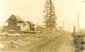
- Photographic postcard of Neville Street just off Royal Oak Avenue. The street is a dirt road lined with residential buildings on one side and eletric power poles on the other side. The Holdsworth house is seen being constructed on the left. There is scaffolding on the side of the building and a cle…
- Repository
- Burnaby Village Museum
- Collection/Fonds
- Burnaby Village Museum Photograph collection
- Description Level
- Item
- Physical Description
- 1 photograph : sepia postcard ; 8.8 x 13.9 cm
- Scope and Content
- Photographic postcard of Neville Street just off Royal Oak Avenue. The street is a dirt road lined with residential buildings on one side and eletric power poles on the other side. The Holdsworth house is seen being constructed on the left. There is scaffolding on the side of the building and a cleared lot beside the house. here are variant spellings of "Holdsworth" used in the notes in the accession file. They are "Houldsworth" and "Hallsworth." The 1937 British Columbia directory lists a Fred Houldsworth at 3345 Neville Street, Burnaby. The address was later renumbered 5249 Neville Street. An annotation on the back of the postcard reads: "Nevil [sic] Street - 1912 - Just off Royal Oak."
- Subjects
- Buildings - Residential - Houses
- Documentary Artifacts - Postcards
- Geographic Features - Roads
- Geographic Access
- Neville Street
- Royal Oak Avenue
- Accession Code
- HV980.12.3
- Access Restriction
- No restrictions
- Reproduction Restriction
- May be restricted by third party rights
- Date
- 1912
- Media Type
- Photograph
- Historic Neighbourhood
- Alta-Vista (Historic Neighbourhood)
- Planning Study Area
- Clinton-Glenwood Area
- Scan Resolution
- 600
- Scan Date
- 2023-09-12
- Notes
- Title based on contents of photograph
Images
Rumble Road
https://search.heritageburnaby.ca/link/archivedescription35165
- Repository
- City of Burnaby Archives
- Date
- [1930]
- Collection/Fonds
- Burnaby Historical Society fonds
- Description Level
- Item
- Physical Description
- 1 photograph : b&w ; 12.7 x 17.8 cm
- Scope and Content
- Photograph of Rumble Road east of Patterson.
- Repository
- City of Burnaby Archives
- Date
- [1930]
- Collection/Fonds
- Burnaby Historical Society fonds
- Subseries
- Pioneer Tales subseries
- Physical Description
- 1 photograph : b&w ; 12.7 x 17.8 cm
- Description Level
- Item
- Record No.
- 204-022
- Access Restriction
- No restrictions
- Reproduction Restriction
- No known restrictions
- Accession Number
- BHS1988-03
- Scope and Content
- Photograph of Rumble Road east of Patterson.
- Subjects
- Geographic Features - Roads
- Media Type
- Photograph
- Photographer
- Stone, Gene
- Notes
- Title based on contents of photograph
- Geographic Access
- Rumble Street
- Patterson Avenue
- Historic Neighbourhood
- Alta-Vista (Historic Neighbourhood)
- Planning Study Area
- Sussex-Nelson Area
Images
Rumble Street
https://search.heritageburnaby.ca/link/archivedescription34255
- Repository
- City of Burnaby Archives
- Date
- 1932
- Collection/Fonds
- Burnaby Historical Society fonds
- Description Level
- Item
- Physical Description
- 1 photograph : b&w ; 12.2 x 17.7 cm
- Scope and Content
- Photograph of Rumble Street looking east toward Patterson Avenue, located where the house on the left can be seen.
- Repository
- City of Burnaby Archives
- Date
- 1932
- Collection/Fonds
- Burnaby Historical Society fonds
- Subseries
- Photographs subseries
- Physical Description
- 1 photograph : b&w ; 12.2 x 17.7 cm
- Description Level
- Item
- Record No.
- 011-002
- Access Restriction
- No restrictions
- Reproduction Restriction
- No known restrictions
- Accession Number
- BHS2007-04
- Scope and Content
- Photograph of Rumble Street looking east toward Patterson Avenue, located where the house on the left can be seen.
- Media Type
- Photograph
- Notes
- Title based on contents of photograph
- Annotation at bottom of Copy 2 reads, "Rumble St. just after Municipal dump was filled / Facing east house on left is where Patterson Avenue [is]"
- Geographic Access
- Rumble Street
- Patterson Avenue
- Historic Neighbourhood
- Alta-Vista (Historic Neighbourhood)
- Planning Study Area
- Sussex-Nelson Area
- Suncrest Area
Images
Rumble Street school zone signs
https://search.heritageburnaby.ca/link/archivedescription97744
- Repository
- City of Burnaby Archives
- Date
- [2002]
- Collection/Fonds
- Burnaby NewsLeader photograph collection
- Description Level
- Item
- Physical Description
- 1 photograph (tiff) : col.
- Scope and Content
- Photograph of City of Burnaby worker Mike Demeda placing a reflective school zone sign on Rumble Street near Suncrest Elementary School. Chris Hildred, Diana Mumfor, and Mark Baxter are watching in the background.
- Repository
- City of Burnaby Archives
- Date
- [2002]
- Collection/Fonds
- Burnaby NewsLeader photograph collection
- Physical Description
- 1 photograph (tiff) : col.
- Description Level
- Item
- Record No.
- 535-3018
- Access Restriction
- No restrictions
- Reproduction Restriction
- No restrictions
- Accession Number
- 2018-12
- Scope and Content
- Photograph of City of Burnaby worker Mike Demeda placing a reflective school zone sign on Rumble Street near Suncrest Elementary School. Chris Hildred, Diana Mumfor, and Mark Baxter are watching in the background.
- Subjects
- Geographic Features - Roads
- Occupations - Civic Workers
- Public Services - Municipal Services
- Media Type
- Photograph
- Photographer
- Bartel, Mario
- Notes
- Title based on caption
- Collected by editorial for use in a November 2002 issue of the Burnaby NewsLeader
- Caption from metadata: "Mike Demeda, of the City of burnaby, places one of the new reflective school zone signs on Rumble St. near Suncrest Elementary. Looking on are Chris Hildred, a volunteer with the SouthWest District, Diana Mumfor, of the traffic and safety committee, and Mark Baxter, of the Burnaby RCMP."
- Geographic Access
- Rumble Street
- Historic Neighbourhood
- Alta Vista (Historic Neighbourhood)
- Planning Study Area
- Suncrest Area


![Diana Mumford at school crossing, [2000] thumbnail](/media/hpo/_Data/_Archives_Images/_Unrestricted/535/535-2867.jpg?width=280)


![Rumble Road, [1930] thumbnail](/media/hpo/_Data/_Archives_Images/_Unrestricted/204/204-022.jpg?width=280)

![Rumble Street school zone signs, [2002] thumbnail](/media/hpo/_Data/_Archives_Images/_Unrestricted/535/535-3018.jpg?width=280)