Narrow Results By
Subject
- Adornment 2
- Adornment - Jewelry 1
- Adornment - Lapel Pins
- Advertising Medium - Signs and Signboards 3
- Aerial Photographs 1
- Agriculture - Farms 1
- Buildings - Commercial 2
- Buildings - Commercial - Grocery Stores
- Buildings - Commercial - Malls 2
- Buildings - Commercial - Service Stations 2
- Buildings - Commercial - Stores 1
- Buildings - Recreational - Community Halls 1

Baxter's Market
https://search.heritageburnaby.ca/link/archivedescription79103
- Repository
- City of Burnaby Archives
- Date
- September 10, 1976
- Collection/Fonds
- Burnaby Public Library Contemporary Visual Archive Project
- Description Level
- Item
- Physical Description
- 1 photograph : b&w ; 11 x 16 cm mounted on cardboard
- Scope and Content
- Photograph shows Baxter's Market at 7658 Royal Oak Avenue near Rumble Street.
- Repository
- City of Burnaby Archives
- Date
- September 10, 1976
- Collection/Fonds
- Burnaby Public Library Contemporary Visual Archive Project
- Physical Description
- 1 photograph : b&w ; 11 x 16 cm mounted on cardboard
- Description Level
- Item
- Record No.
- 556-154
- Access Restriction
- No restrictions
- Reproduction Restriction
- Reproduce for fair dealing purposes only
- Accession Number
- 2013-13
- Scope and Content
- Photograph shows Baxter's Market at 7658 Royal Oak Avenue near Rumble Street.
- Names
- Baxter's Market
- Media Type
- Photograph
- Photographer
- Ross, Martha
- Notes
- Scope note taken directly from BPL photograph description.
- 1 b&w copy negative : 10 x 12.5 cm accompanying
- Geographic Access
- Royal Oak Avenue
- Rumble Street
- Street Address
- 7658 Royal Oak Avenue
- Historic Neighbourhood
- Alta-Vista (Historic Neighbourhood)
- Planning Study Area
- Clinton-Glenwood Area
Images

lapel pin
https://search.heritageburnaby.ca/link/museumartifact48592
- Repository
- Burnaby Village Museum
- Accession Code
- BV005.35.19
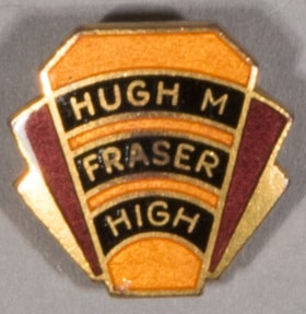
- Description
- Pin, high school; yellow, gold, maroon, black; writing in three black bars across front golden yellow panel; "HUGH M / FRASER / HIGH"; maroon and gold geometric shapes fan out behind it; screw fastener
- Object History
- Burnaby South High School was renamed Hugh M. Fraser High in 1941?, but was changed back to the original name a short time later. Hugh M. Fraser was appointed commissioner of the municipality of Burnaby when it was forced into receivership and at the end of 1932, after a dispute with the Provincial government about relief payments for the unemployed. A Provincial Commission stepped in to take over the governance of the city, under Hugh M. Fraser.
- Marks/Labels
- "HUGH M. / FRASER / HIGH", gold letters in three black bars across front panel
- Subjects
- Adornment
- Adornment - Lapel Pins
- Geographic Access
- Rumble Street
Images


lapel pin
https://search.heritageburnaby.ca/link/museumartifact89261
- Repository
- Burnaby Village Museum
- Accession Code
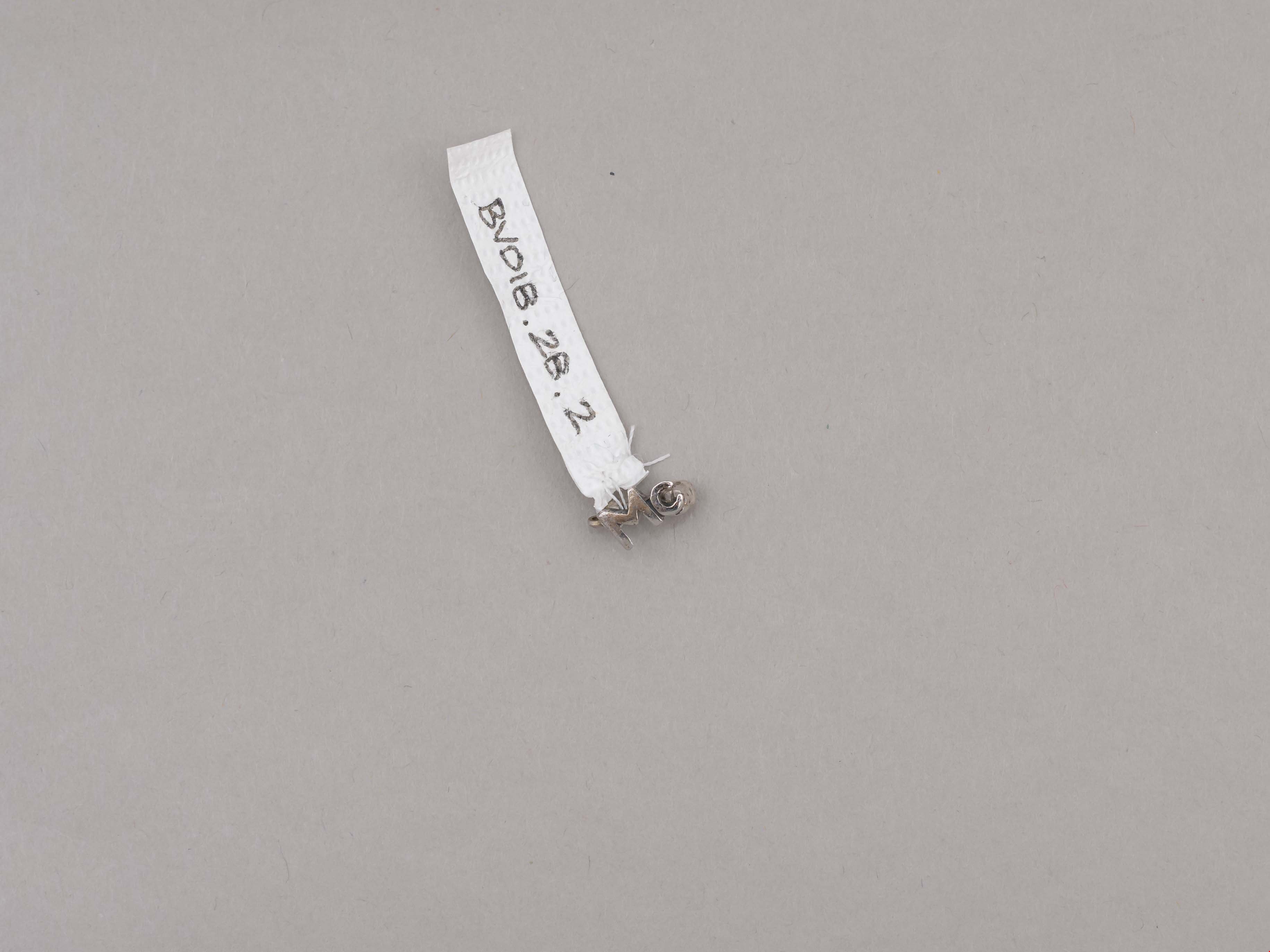
- BV018.28.2
- Description
- lapel pin; silver "Mc" with locking pin back; letters "Mc" represent McPherson Park Junior Secondary School; ca. 1970.
- Object History
- Donor attended Sussex Avenue School in 1964-65 for grade 5, 1965-66 for grade 6 and 1966-1967 for grade 7.
- Donor attended McPherson Park Junior Secondary School for grades 8-10 from Sept 1967-June 1970. The double academic and athletic crests and the "Mc" pin were received in grade 10.
- Category
- 03. Personal Artifacts
- Subjects
- Adornment - Lapel Pins
- Souvenirs
- Geographic Access
- Rumble Street
- Street Address
- 5455 Rumble Street
- Historic Neighbourhood
- Alta Vista (Historic Neighbourhood)
- Planning Study Area
- Clinton-Glenwood Area
Images

Nelsons Grocery
https://search.heritageburnaby.ca/link/archivedescription79100
- Repository
- City of Burnaby Archives
- Date
- October, 1976
- Collection/Fonds
- Burnaby Public Library Contemporary Visual Archive Project
- Description Level
- Item
- Physical Description
- 1 photograph : b&w ; 11 x 16 cm mounted on cardboard
- Scope and Content
- Photograph shows Nelsons Grocery at 4909 Rumble Street at the corner of Nelson Avenue and Rumble Street.
- Repository
- City of Burnaby Archives
- Date
- October, 1976
- Collection/Fonds
- Burnaby Public Library Contemporary Visual Archive Project
- Physical Description
- 1 photograph : b&w ; 11 x 16 cm mounted on cardboard
- Description Level
- Item
- Record No.
- 556-152
- Access Restriction
- No restrictions
- Reproduction Restriction
- Reproduce for fair dealing purposes only
- Accession Number
- 2013-13
- Scope and Content
- Photograph shows Nelsons Grocery at 4909 Rumble Street at the corner of Nelson Avenue and Rumble Street.
- Names
- Nelsons Grocery
- Media Type
- Photograph
- Photographer
- McCarron, John
- Notes
- Scope note taken directly from BPL photograph description.
- 1 b&w copy negative : 10 x 12.5 cm accompanying
- Geographic Access
- Rumble Street
- Nelson Avenue
- Street Address
- 4909 Rumble Street
- Historic Neighbourhood
- Alta-Vista (Historic Neighbourhood)
- Planning Study Area
- Sussex-Nelson Area
Images


Royal Oak Plaza
https://search.heritageburnaby.ca/link/archivedescription93605
- Repository
- City of Burnaby Archives
- Date
- October 9, 1977
- Collection/Fonds
- Burnaby Public Library Contemporary Visual Archive Project
- Description Level
- Item
- Physical Description
- 1 photograph : b&w ; 12.5 x 17.5 cm
- Scope and Content
- Photograph of Royal Oak Plaza's parking lot and sign, located at Royal Oak and Rumble Street. The photograph is taken facing north. A Safeway is visible in the background.
- Repository
- City of Burnaby Archives
- Date
- October 9, 1977
- Collection/Fonds
- Burnaby Public Library Contemporary Visual Archive Project
- Physical Description
- 1 photograph : b&w ; 12.5 x 17.5 cm
- Description Level
- Item
- Record No.
- 556-562
- Access Restriction
- No restrictions
- Reproduction Restriction
- Reproduce for fair dealing purposes only
- Accession Number
- 2017-57
- Scope and Content
- Photograph of Royal Oak Plaza's parking lot and sign, located at Royal Oak and Rumble Street. The photograph is taken facing north. A Safeway is visible in the background.
- Subjects
- Advertising Medium - Signs and Signboards
- Buildings - Commercial - Grocery Stores
- Buildings - Commercial - Malls
- Media Type
- Photograph
- Photographer
- Chapman, Fred
- Notes
- Title taken from project information form
- Accompanied by a project information form and 1 photograph (b&w negative ; 9.5 x 12.5 cm)
- BPL no. 6
- Geographic Access
- Royal Oak Avenue
- Rumble Street
- Historic Neighbourhood
- Central Park (Historic Neighbourhood)
- Planning Study Area
- Clinton-Glenwood Area
Images
