Narrow Results By
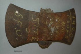
double bit axe head
https://search.heritageburnaby.ca/link/museumartifact45469
- Repository
- Burnaby Village Museum
- Accession Code
- BV003.28.3
- Description
- This split, double bitted, utility axe head was found on Burnaby Mountain by Alfred Bingham in 1920. Mr Bingham bought property on the West side of the mountain in 1920. The axe head is double bladed. The head is very rusty and has been cracked across one side. The remains of the handle are still in the axe eye.
- Object History
- The axe head was found on the site of Simon Fraser University (SFU), an area logged in the early years of the 20th Century by Gilley Logging. The axe may have been broken by one of their loggers.
- Reference
- Note from Alfred Bingham, original in accession file. "THIS AXE HEAD WAS FOUND IN 1920 / BY ALFRED BINGHAM ON THE PRESENT SITE / OF THE SIMON FRASER UNIVERSITY. IT PROBABLY / WAS USED BY AN EARLY LOGGER. WHO CUT DOWN / SOME OF THE GREAT TREES THAT GREW ON / BURNABY MOUNTAIN. HUNDREDS OF YEARS AGO. MANY OF THESE TREES WERE OVER 800 YEARS OLD / Alfred Bingham " hand written in ink on one face of note. "I bought 5 acres of stump land on the / corner of Sherlock, Duthie, & Kitchener Streets in / 1920. & cleared 2 acres & bilt small home, (store?) / my wife and I have lived in Burnaby continually since then / AB" hand written in ink on the reverse face of the note.
- Marks/Labels
- "1920 FOUND ON BURNABY MTN SITE S.F.U.", written in yellow chalk on one face of the axe head
- Geographic Access
- Burnaby Mountain Conservation Area
- Planning Study Area
- Burnaby Mountain Area
Images

![Looking down north Poleline Hill, [1908] thumbnail](/media/hpo/_Data/_BVM_Images/1976/1976_0139_0047_001.jpg?width=280)
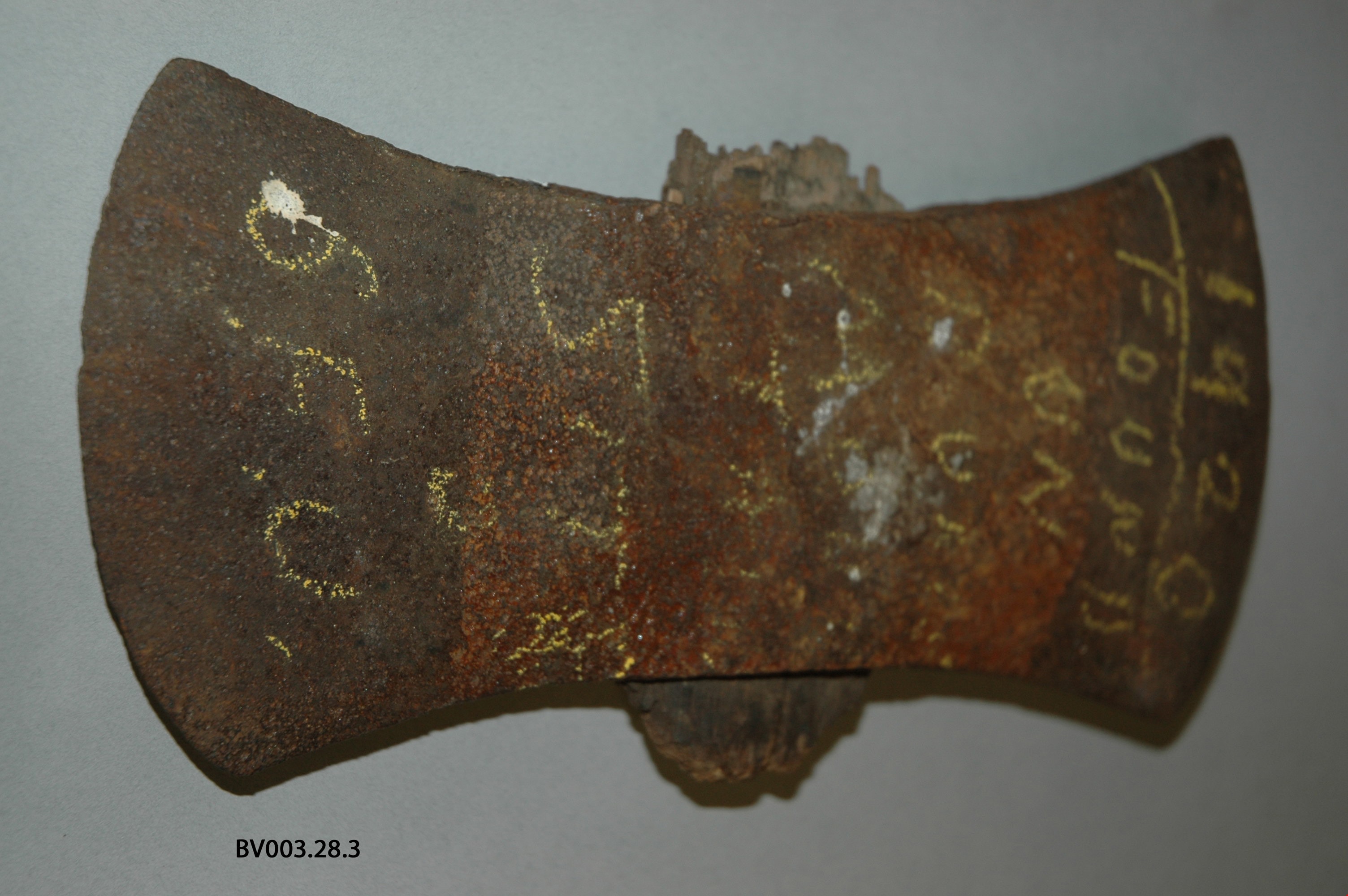
Looking down north Poleline Hill
https://search.heritageburnaby.ca/link/museumdescription796
- Repository
- Burnaby Village Museum
- Date
- [1908]
- Collection/Fonds
- Burnaby Village Museum Photograph collection
- Description Level
- Item
- Physical Description
- 1 photograph : b&w ; 20.32 x 25.4 cm print
- Scope and Content
- Photograph looking north along the Pole Line Road (later Sperling Avenue). To the far left is Deer Lake and at the top right is Burnaby Lake. The smoke and debris from land clearing is a result of logging operations being carried out by the Doran Brothers logging company, the Deer Lake Mill Company…
- Repository
- Burnaby Village Museum
- Collection/Fonds
- Burnaby Village Museum Photograph collection
- Description Level
- Item
- Physical Description
- 1 photograph : b&w ; 20.32 x 25.4 cm print
- Material Details
- inscribed in pencil, verso, l.l. "Looking down north Poleline Hill (now Sperling) Deer Lake at left. "
- Scope and Content
- Photograph looking north along the Pole Line Road (later Sperling Avenue). To the far left is Deer Lake and at the top right is Burnaby Lake. The smoke and debris from land clearing is a result of logging operations being carried out by the Doran Brothers logging company, the Deer Lake Mill Company. Above Deer Lake, Douglas Road is visible with Claude Hill's Brookfield property (later 6501 Deer Lake Avenue) on the south side of the road and Bernard Hill's home on the north side (later 4990 Canada Way). Just northeast of Brookfield is the George Every-Clayton farm (amongst the trees) on what would later become the Henry and Grace Ceperley estate grounds known as Fairacres. The house in the centre of the picture is the Walker house (later 5255 Sperling Avenue). Mountains can be seen to the north.
- Subjects
- Land Clearing
- Geographic Features - Roads
- Industries - Forestry
- Industries - Logging/lumber
- Geographic Access
- Sperling Avenue
- Deer Lake
- Douglas Road
- Canada Way
- Accession Code
- HV976.139.47
- Access Restriction
- No restrictions
- Reproduction Restriction
- No known restrictions
- Date
- [1908]
- Media Type
- Photograph
- Historic Neighbourhood
- Burnaby Lake (Historic Neighbourhood)
- Planning Study Area
- Morley-Buckingham Area
- Scan Resolution
- 600
- Scan Date
- 2023-06-27
- Notes
- Title based on contents of photograph
Images
![Looking down north Poleline Hill, [1908] thumbnail](/media/hpo/_Data/_BVM_Images/1976/1976_0139_0047_001.jpg)