Narrow Results By
5650 Lougheed Hwy
https://search.heritageburnaby.ca/link/archivedescription94350
- Repository
- City of Burnaby Archives
- Date
- October 1995
- Collection/Fonds
- Grover, Elliott & Co. Ltd. fonds
- Description Level
- File
- Physical Description
- 28 photographs : col. negatives ; 35 mm
- Scope and Content
- Photographs of the commerical properties located at Lougheed Highway, Holdom Avenue, and Goring Street. Stores visible in the photograph include Lumberland, located at 5650 Lougheed Highway - an address that no longer exists.
- Repository
- City of Burnaby Archives
- Date
- October 1995
- Collection/Fonds
- Grover, Elliott & Co. Ltd. fonds
- Physical Description
- 28 photographs : col. negatives ; 35 mm
- Description Level
- File
- Record No.
- 622-135
- Access Restriction
- No restrictions
- Reproduction Restriction
- No restrictions
- Accession Number
- 2017-39
- Scope and Content
- Photographs of the commerical properties located at Lougheed Highway, Holdom Avenue, and Goring Street. Stores visible in the photograph include Lumberland, located at 5650 Lougheed Highway - an address that no longer exists.
- Subjects
- Buildings - Commercial
- Names
- Lumberland
- Media Type
- Photograph
- Photographer
- Young, Richard
- Notes
- Transcribed title
- Title transcribed from envelope photographs were originally housed in
- File no. 95-357-B
- Sticky note adhered to 622-135-18 print reads: "1) View south west from Lougheed Hwy."
- Sticky note adhered to 622-135-23 print reads: "2) The two level building - view south"
- Sticky note adhered to 622-135-1 print reads: "3) The east yard area - view south"
- Sticky note adhered to 622-135-4 print reads: "4) View north west from Holdom Ave."
- Sticky note adhered to 622-135-20 print reads: "5) View west along Lougheed Hwy."
- Sticky note adhered to 622-135-26 print reads: "6) View east along Lougheed Hwy."
- Sticky note adhered to 622-135-13 print reads: "7) View south along Holdmon Ave."
- Sticky note adhered to 622-135-7 print reads: "8) View north along Holdom Ave."
- Sticky note adherd to 622-135-10 print reads: "10) View west along Goring St."
- Geographic Access
- Lougheed Highway
- Holdom Avenue
- Goring Street
- Planning Study Area
- Parkcrest-Aubrey Area
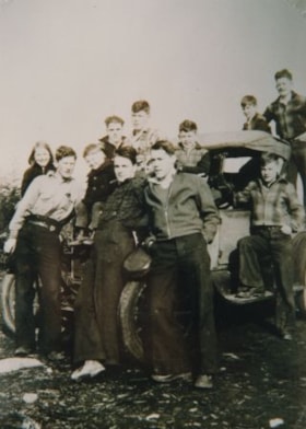
Capitol Hill kids
https://search.heritageburnaby.ca/link/archivedescription36509
- Repository
- City of Burnaby Archives
- Date
- 1937
- Collection/Fonds
- Burnaby Historical Society fonds
- Description Level
- Item
- Physical Description
- 1 photograph : col. ; 14 x 10 cm print
- Scope and Content
- Photograph of a group of Capitol Hill kids standing on and around the Model A Ford that they bought between them for $10.00. The kids in the front are; Lena Wilson, Teddy Armstrong, Larry Armstrong, Glen Wilson, Don Henderson, and Jack Chapman. The kids in the back are; Norman Wilson, Ken Wilson, …
- Repository
- City of Burnaby Archives
- Date
- 1937
- Collection/Fonds
- Burnaby Historical Society fonds
- Subseries
- Photographs subseries
- Physical Description
- 1 photograph : col. ; 14 x 10 cm print
- Description Level
- Item
- Record No.
- 287-001
- Access Restriction
- No restrictions
- Reproduction Restriction
- No known restrictions
- Accession Number
- BHS1992-22
- Scope and Content
- Photograph of a group of Capitol Hill kids standing on and around the Model A Ford that they bought between them for $10.00. The kids in the front are; Lena Wilson, Teddy Armstrong, Larry Armstrong, Glen Wilson, Don Henderson, and Jack Chapman. The kids in the back are; Norman Wilson, Ken Wilson, Dickie Parrott, unidentified, and Tom Babbitt. They are parked on Ellesmere Avenue.
- Subjects
- Transportation - Automobiles
- Names
- Wilson, Lena
- Armstrong, Teddy
- Armstrong, Larry
- Wilson, Glen
- Henderson, Donald
- Chapman, Jack
- Wilson, Norman
- Wilson, Ken
- Parrott, Dickie
- Babbitt, Tom
- Media Type
- Photograph
- Notes
- Title based on title on verso of print
- Copied in col. from sepia original
- Note on verso of print identifies individuals
- Geographic Access
- Ellesmere Avenue
- Historic Neighbourhood
- Capitol Hill (Historic Neighbourhood)
- Planning Study Area
- Capitol Hill Area
- Parkcrest-Aubrey Area
Images


Parkcrest Plaza
https://search.heritageburnaby.ca/link/archivedescription93653
- Repository
- City of Burnaby Archives
- Date
- October 23, 1977
- Collection/Fonds
- Burnaby Public Library Contemporary Visual Archive Project
- Description Level
- Item
- Physical Description
- 1 photograph : b&w ; 12.5 x 17.5 cm
- Scope and Content
- Photograph of the Parkcrest Plaza shopping centre at Sperling and Broadway. The photograph is taken from across the parking lot and lawn, facing west. Signs for the plaza's businesses include Fresh Foods and Bank of Nova Scotia, and homes and apartment buildings are in the distance.
- Repository
- City of Burnaby Archives
- Date
- October 23, 1977
- Collection/Fonds
- Burnaby Public Library Contemporary Visual Archive Project
- Physical Description
- 1 photograph : b&w ; 12.5 x 17.5 cm
- Description Level
- Item
- Record No.
- 556-610
- Access Restriction
- No restrictions
- Reproduction Restriction
- Reproduce for fair dealing purposes only
- Accession Number
- 2017-57
- Scope and Content
- Photograph of the Parkcrest Plaza shopping centre at Sperling and Broadway. The photograph is taken from across the parking lot and lawn, facing west. Signs for the plaza's businesses include Fresh Foods and Bank of Nova Scotia, and homes and apartment buildings are in the distance.
- Subjects
- Buildings - Commercial - Grocery Stores
- Buildings - Commercial - Malls
- Buildings - Commercial - Banks
- Buildings - Commercial - Stores
- Media Type
- Photograph
- Photographer
- Chapman, Fred
- Notes
- Title taken from project information form
- Accompanied by a project information form and 1 photograph (b&w negative ; 9.5 x 12.5 cm)
- BPL no. 60
- Geographic Access
- Sperling Avenue
- Broadway
- Street Address
- 5901 Sperling Avenue
- Planning Study Area
- Parkcrest-Aubrey Area
Images
