Narrow Results By
Subject
- Buildings - Industrial - Factories 1
- Buildings - Residential - Houses 1
- Geographic Features - Inlets 2
- Indigenous peoples - British Columbia 1
- Indigenous peoples - British Columbia - First contact with Europeans 1
- Indigenous peoples - British Columbia - Languages 1
- Indigenous peoples - Canada - Government relations 1
- Indigenous peoples - Canada - , Treatment of 1
- Sports - Swimming 2

Bringing Visibility to the Land: A Tsleil-Waututh Perspective on Community Building
https://search.heritageburnaby.ca/link/museumdescription15665
- Repository
- Burnaby Village Museum
- Date
- 27 Apr. 2021
- Collection/Fonds
- Burnaby Village Museum fonds
- Description Level
- Item
- Physical Description
- 1 video recording (mp4) (47 min., 39 sec.) : digital, col., sd., stereo ; 29 fps
- Scope and Content
- Item consists of a video recording of a live Zoom webinar hosted by Burnaby Village Museum Curator, Jane Lemke. The webinar is titled "Bringing Visibility to the Land: A Tsleil-Waututh Perspective on Community Building" and is presented by Michelle George, Tsleil-Waututh Nation Cultural and Technic…
- Repository
- Burnaby Village Museum
- Collection/Fonds
- Burnaby Village Museum fonds
- Description Level
- Item
- Physical Description
- 1 video recording (mp4) (47 min., 39 sec.) : digital, col., sd., stereo ; 29 fps
- Material Details
- Presenters: Michelle George
- Host: Jane Lemke
- Date of Presentation: Tuesday, April 27, 7:00 pm - 8:00 pm
- Total Number of tracks: 1
- Total Length of all tracks: 47 min., 39 sec.
- Recording Device: Zoom video communication platform
- Recording Note: Film was edited from it's original recorded version (63 min., 29 sec.) to edited version (47 min., 39 sec.) for public viewing on Heritage Burnaby
- Scope and Content
- Item consists of a video recording of a live Zoom webinar hosted by Burnaby Village Museum Curator, Jane Lemke. The webinar is titled "Bringing Visibility to the Land: A Tsleil-Waututh Perspective on Community Building" and is presented by Michelle George, Tsleil-Waututh Nation Cultural and Technical Specialist. The Zoom webinar is the first in a series of six "Neighbourhood Speaker series" webinars exploring a range of topics shared by Indigenous speakers and knowledge keepers that were presented and made available to the public between April 27 and May 12, 2021. The live webinar was also made available on the Burnaby Village Museum's facebook page. Community members were invited to participate by bringing questions during the interactive online sessions. In this webinar, Michelle George explores the importance of bringing Tsleil-Waututh ways of knowing/knowledge of the land to Burnaby. She grounds her talk with her experience of working with the Burnaby Village Museum on producing the Indigenous History of Burnaby Resource Guide, an award-winning illustrated educational guide. Michelle also speaks to some of the devastating experiences that the Tsleil-Waututh Nation and Indigenous Peoples have suffered since Colonial Settlement and how her Nation has begun to grow in a changing environment. In segments of her talk, Michelle refers to a map titled "Tsleil-Waututh Nation Consultation Area". Following the presentation, Michelle George answers questions from the audience that are moderated by the host, Jane Lemke.
- History
- Michelle George is a member of the Tsleil-Waututh Nation (TWN) and currently works as a Tsleil-Waututh Nation Cultural and Technical Specialist for the Treaty, Lands and Resources (TLR) Department. She participates in various projects for the TWN government and community, focusing on Tsleil-Waututh Governance and Community. The goals that she carries in her work are to make sure Tsleil-Waututh culture is included and considered in these Nation-level projects, as well as within the reviews done on external projects within the TWN Consultation area. She has been a member of both the Tsleil-Waututh Land Code Committee and Land Use Planning group. Michelle is also a First Nations Health Authority Traditional Knowledge Keeper, and a past-Elected Councilor for Tsleil-Waututh Nation. Michelle also provides guest lectures at Simon Fraser University, Langara College, and the BC Institute of Technology.
- Creator
- Burnaby Village Museum
- Subjects
- Indigenous peoples - British Columbia
- Indigenous peoples - Canada - Government relations
- Indigenous peoples - British Columbia - Languages
- Indigenous peoples - Canada - , Treatment of
- Indigenous peoples - British Columbia - First contact with Europeans
- Names
- Burnaby Village Museum
- Burnaby Public Library
- George, Michelle
- Tsleil-Waututh Nation
- George, Chief Daniel "Dan"
- Responsibility
- Lemke, Jane
- Geographic Access
- Burrard Inlet
- Accession Code
- BV021.17.1
- Access Restriction
- No restrictions
- Reproduction Restriction
- No known restrictions
- Date
- 27 Apr. 2021
- Media Type
- Moving Images
- Notes
- Title based on contents of video recording
Images

Video
Bringing Visibility to the Land: A Tsleil-Waututh Perspective on Community Building, 27 Apr. 2021
Bringing Visibility to the Land: A Tsleil-Waututh Perspective on Community Building, 27 Apr. 2021
https://search.heritageburnaby.ca/media/hpo/_Data/_BVM_Moving_Images/2021_0017_0001_002.mp4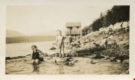
David and Ray McManus at Burrard Inlet
https://search.heritageburnaby.ca/link/museumdescription76
- Repository
- Burnaby Village Museum
- Date
- 1932
- Collection/Fonds
- Burnaby Village Museum Photograph collection
- Description Level
- Item
- Physical Description
- 1 photograph : sepia ; 6 x 10.5 cm
- Scope and Content
- Photograph of brothers David and Ray McManus playing near the Burrard Inlet in their swimsuits. A house is visible in the background. The photograph was taken at the foot of Willingdon Avenue looking up the inlet towards Dollarton.
- Repository
- Burnaby Village Museum
- Collection/Fonds
- Burnaby Village Museum Photograph collection
- Description Level
- Item
- Physical Description
- 1 photograph : sepia ; 6 x 10.5 cm
- Scope and Content
- Photograph of brothers David and Ray McManus playing near the Burrard Inlet in their swimsuits. A house is visible in the background. The photograph was taken at the foot of Willingdon Avenue looking up the inlet towards Dollarton.
- Names
- McManus, David
- McManus, Ray
- Geographic Access
- Burrard Inlet
- Accession Code
- BV989.19.6
- Access Restriction
- No restrictions
- Reproduction Restriction
- No known restrictions
- Date
- 1932
- Media Type
- Photograph
- Scan Resolution
- 600
- Scan Date
- 01-Jun-09
- Scale
- 100
- Notes
- Title based on contents of photograph
- Note written in blue pen on verso of photograph reads: "Burrard Inlet/ 1932/ David + RAY/ McMANUS/ Foot of Willingdon looking/ up inlet toward Dollarton"
- Stamp on verso of photograph reads: "Vancouver Drug Co./ Ltd./ Nu-Gloss/ PHOTO FINISH"
Images

Dominion Bridge Company Limited - Burnaby Plant
https://search.heritageburnaby.ca/link/museumdescription17538
- Repository
- Burnaby Village Museum
- Date
- 29 Aug. 1957
- Collection/Fonds
- Burnaby Village Museum Map collection
- Description Level
- Item
- Physical Description
- 1 plan : col. lithographic print ; 50.5 x 84 cm
- Scope and Content
- Item consists of a fire insurance plan of the Dominion Bridge Company Burnaby Plant located on the east side of Boundary Road near Lougheed Highway. The plan is in two sheets mounted on a backing board. The buildings are located and colour coded. The plan includes profiles of the buildings. Title o…
- Repository
- Burnaby Village Museum
- Collection/Fonds
- Burnaby Village Museum Map collection
- Description Level
- Item
- Physical Description
- 1 plan : col. lithographic print ; 50.5 x 84 cm
- Material Details
- Scale [1:960]
- Scope and Content
- Item consists of a fire insurance plan of the Dominion Bridge Company Burnaby Plant located on the east side of Boundary Road near Lougheed Highway. The plan is in two sheets mounted on a backing board. The buildings are located and colour coded. The plan includes profiles of the buildings. Title on plan reads "DOMINION BRIDGE COMPANY, LIMITED / "BURNABY PLANT" / Burnaby, B.C.". The site plan was surveyed by C. L. Schwaab Jr.
- History
- Dominion Bridge Company was a major enterprise in Burnaby operating from the 1930 until the mid 1970s. Dominion Bridge constructed steel structures ranging from portions of the Golden Gate and Lions Gate Bridges to holding tanks for pulp mills. Beginning in the mid-1970s, unused areas of the site were used for filming on a temporary basis and in 1987 the site was established as a dedicated studio production facility named Bridge Studios.
- Creator
- Schwabb, C.L. Jr.
- Subjects
- Buildings - Industrial - Factories
- Names
- Dominion Bridge Company
- Responsibility
- Associated Factory Mutual Fire Insurance Cos
- Geographic Access
- Boundary Road
- Street Address
- 2400 Boundary Road
- Accession Code
- BV015.10.1
- Access Restriction
- Restricted access
- Reproduction Restriction
- May be restricted by third party rights
- Date
- 29 Aug. 1957
- Media Type
- Cartographic Material
- Historic Neighbourhood
- Broadview (Historic Neighbourhood)
- Planning Study Area
- West Central Valley Area
- Scan Resolution
- 400
- Scan Date
- 2021-11-28
- Notes
- Title based on contents of plan
- Scale on plan reads "1 inch = 80 ft / By V. Pitkin"
- Identfication information in bottom right corner of plan reads: "FACTORY MUTUAL ENGINEERING DIVISION / Associated Factory Mutual Fire Insurance Cos. / Norwood, Mass. / SERIAl 47330 / Replacing 35238 / INDEX 3994"
![Home of Richard and Clara Thorpe, [1911] thumbnail](/media/hpo/_Data/_BVM_Images/1990/199900610001.jpg?width=280)
Home of Richard and Clara Thorpe
https://search.heritageburnaby.ca/link/museumdescription1507
- Repository
- Burnaby Village Museum
- Date
- [1911]
- Collection/Fonds
- Burnaby Village Museum Photograph collection
- Description Level
- Item
- Physical Description
- 1 photograph : b&w ; 10x 14 cm, mounted on card 15 x 22.5 cm
- Scope and Content
- Photograph of the home of Richard and Clara Thorpe. Nancy Davis Allard is standing, holding baby Dorothy Thorp (later Spain) upright in a buggy at the foot of the stairs. Two unidentified woman are also visible sitting at the top of the stairs.
- Repository
- Burnaby Village Museum
- Collection/Fonds
- Burnaby Village Museum Photograph collection
- Description Level
- Item
- Physical Description
- 1 photograph : b&w ; 10x 14 cm, mounted on card 15 x 22.5 cm
- Scope and Content
- Photograph of the home of Richard and Clara Thorpe. Nancy Davis Allard is standing, holding baby Dorothy Thorp (later Spain) upright in a buggy at the foot of the stairs. Two unidentified woman are also visible sitting at the top of the stairs.
- Subjects
- Buildings - Residential - Houses
- Geographic Access
- Boundary Road
- Burke Street
- Accession Code
- BV999.61.1
- Access Restriction
- No restrictions
- Date
- [1911]
- Media Type
- Photograph
- Historic Neighbourhood
- Central Park (Historic Neighbourhood)
- Planning Study Area
- Garden Village Area
- Scan Resolution
- 600
- Scan Date
- 09-Jun-09
- Scale
- 100
- Notes
- Title based on contents of photograph
- Note in blue ink on verso of photograph reads: "Home of Richard and/ Clara Thorp - about 1911./ Built in 1907. Boundary/ & Burke St. - Burnaby/ I'm in the buggy, held upright by my/ dear friend Nance -"
Images
![Home of Richard and Clara Thorpe, [1911] thumbnail](/media/hpo/_Data/_BVM_Images/1990/199900610001.jpg)
![Aili Rintanen (later Topalian) holding cat, next to her sister who has a rooster in her arms, [1937]. Item no. 337-003. thumbnail](/media/hpo/_Data/_Archives_Images/_Unrestricted/316/337-003.jpg?width=280)
Interview with Aili Topalian by Eric Damer October 11, 2012 - Track 1
https://search.heritageburnaby.ca/link/oralhistory419
- Repository
- City of Burnaby Archives
- Date Range
- 1920-1945
- Length
- 0:10:12
- Summary
- This portion of the recording pertains mainly to Aili (Rintanen) Topalian's parents. Aili tells the story of her parents meeting, getting married and eventually setting in Crabtown with their two children. She explains what it was like to live in Crabtown during the depression years; the homes were…
- Repository
- City of Burnaby Archives
- Summary
- This portion of the recording pertains mainly to Aili (Rintanen) Topalian's parents. Aili tells the story of her parents meeting, getting married and eventually setting in Crabtown with their two children. She explains what it was like to live in Crabtown during the depression years; the homes were built on decks which were on top of pilings, that were sunk deep into the sand.
- Date Range
- 1920-1945
- Photo Info
- Aili Rintanen (later Topalian) holding cat, next to her sister who has a rooster in her arms, [1937]. Item no. 337-003.
- Length
- 0:10:12
- Geographic Access
- Burrard Inlet
- Historic Neighbourhood
- Vancouver Heights (Historic Neighbourhood)
- Interviewer
- Damer, Eric
- Interview Date
- October 11, 2012
- Scope and Content
- Recording is an interview with Aili (Rintanen) Topalian conducted by Burnaby Village Museum employee Eric Damer, October 11, 2012. Major theme discussed: growing up in Crabtown.
- Biographical Notes
- Aili Rintanen (later Topalian) came to British Columbia in 1936 from a homestead near Burnt Lake, Alberta. After a few months in Vancouver and then a Burnaby apartment, the Rintanens moved to a house on the Burrard Inlet. The family lived over the water, in a house built on a deck, secured to the top of pilings that were sunk deep into the sand. Aili's mother Aune Rintanen found work at a fish and chip shop in downtown Vancouver and her father Gus Rintanen worked in a nearby mill. Aili and her sister Trudi (later Tuomi), attended school in Burnaby. For nine years the Rintanens created a home for themselves in an area now called Crabtown, although no one living there called it that.
- Total Tracks
- 4
- Total Length
- 0:39:00
- Interviewee Name
- Topalian, Aili Rintanen
- Interview Location
- Interviewee's residence
- Interviewer Bio
- Eric Damer is a lifelong British Columbian born in Victoria, raised in Kamloops, and currently residing in Burnaby. After studying philosophy at the University of Victoria, he became interested in the educational forces that had shaped his own life. He completed master’s and doctoral degrees in educational studies at the University of British Columbia with a particular interest in the history of adult and higher education in the province. In 2012, Eric worked for the City of Burnaby as a field researcher and writer, conducting interviews for the City Archives and Museum Oral History Program.
- Collection/Fonds
- Community Heritage Commission Special Projects fonds
- Transcript Available
- None
- Media Type
- Sound Recording
Images
![Aili Rintanen (later Topalian) holding cat, next to her sister who has a rooster in her arms, [1937]. Item no. 337-003. thumbnail](/media/hpo/_Data/_Archives_Images/_Unrestricted/316/337-003.jpg)
Audio Tracks
Track one of recording of interview with Aili Topalian
Track one of recording of interview with Aili Topalian
https://search.heritageburnaby.ca/media/hpo/_Data/_Archives_Oral_Histories/_Unrestricted/MSS171-028/MSS171-028_Track_1.mp3
Interview with Aili Topalian by Eric Damer October 11, 2012 - Track 2
https://search.heritageburnaby.ca/link/oralhistory420
- Repository
- City of Burnaby Archives
- Date Range
- 1920-1945
- Length
- 0:07:49
- Summary
- This portion of the recording pertains to Aili (Rintanen) Topalian's collection of photographs. Aili describes each photograph and tells stories of her childhood along the waterfront at Burrard Inlet; the homes of Crabtown were built on decks which were on top of pilings, that were sunk deep into t…
- Repository
- City of Burnaby Archives
- Summary
- This portion of the recording pertains to Aili (Rintanen) Topalian's collection of photographs. Aili describes each photograph and tells stories of her childhood along the waterfront at Burrard Inlet; the homes of Crabtown were built on decks which were on top of pilings, that were sunk deep into the sand.
- Date Range
- 1920-1945
- Photo Info
- Aili Rintanen (later Topalian) holding cat, next to her sister who has a rooster in her arms, [1937]. Item no. 337-003.
- Length
- 0:07:49
- Geographic Access
- Burrard Inlet
- Historic Neighbourhood
- Vancouver Heights (Historic Neighbourhood)
- Interviewer
- Damer, Eric
- Interview Date
- October 11, 2012
- Scope and Content
- Recording is an interview with Aili (Rintanen) Topalian conducted by Burnaby Village Museum employee Eric Damer, October 11, 2012. Major theme discussed: growing up in Crabtown.
- Biographical Notes
- Aili Rintanen (later Topalian) came to British Columbia in 1936 from a homestead near Burnt Lake, Alberta. After a few months in Vancouver and then a Burnaby apartment, the Rintanens moved to a house on the Burrard Inlet. The family lived over the water, in a house built on a deck, secured to the top of pilings that were sunk deep into the sand. Aili's mother Aune Rintanen found work at a fish and chip shop in downtown Vancouver and her father Gus Rintanen worked in a nearby mill. Aili and her sister Trudi (later Tuomi), attended school in Burnaby. For nine years the Rintanens created a home for themselves in an area now called Crabtown, although no one living there called it that.
- Total Tracks
- 4
- Total Length
- 0:39:00
- Interviewee Name
- Topalian, Aili Rintanen
- Interview Location
- Interviewee's residence
- Interviewer Bio
- Eric Damer is a lifelong British Columbian born in Victoria, raised in Kamloops, and currently residing in Burnaby. After studying philosophy at the University of Victoria, he became interested in the educational forces that had shaped his own life. He completed master’s and doctoral degrees in educational studies at the University of British Columbia with a particular interest in the history of adult and higher education in the province. In 2012, Eric worked for the City of Burnaby as a field researcher and writer, conducting interviews for the City Archives and Museum Oral History Program.
- Collection/Fonds
- Community Heritage Commission Special Projects fonds
- Transcript Available
- None
- Media Type
- Sound Recording
Images
Audio Tracks
Track two of recording of interview with Aili Topalian
Track two of recording of interview with Aili Topalian
https://search.heritageburnaby.ca/media/hpo/_Data/_Archives_Oral_Histories/_Unrestricted/MSS171-028/MSS171-028_Track_2.mp3
Interview with Aili Topalian by Eric Damer October 11, 2012 - Track 3
https://search.heritageburnaby.ca/link/oralhistory421
- Repository
- City of Burnaby Archives
- Date Range
- 1937-1949
- Length
- 0:10:42
- Summary
- This portion of the recording pertains to Aili (Rintanen) Topalian's childhood along the waterfront at Burrard Inlet (the homes of Crabtown were built on decks which were on top of pilings, that were sunk deep into the sand). Aili describes her childhood neighbours, her family home, family friends,…
- Repository
- City of Burnaby Archives
- Summary
- This portion of the recording pertains to Aili (Rintanen) Topalian's childhood along the waterfront at Burrard Inlet (the homes of Crabtown were built on decks which were on top of pilings, that were sunk deep into the sand). Aili describes her childhood neighbours, her family home, family friends, dance halls, and the Marine Building in Vancouver.
- Date Range
- 1937-1949
- Photo Info
- Aili Rintanen (later Topalian) holding cat, next to her sister who has a rooster in her arms, [1937]. Item no. 337-003.
- Length
- 0:10:42
- Geographic Access
- Burrard Inlet
- Historic Neighbourhood
- Vancouver Heights (Historic Neighbourhood)
- Interviewer
- Damer, Eric
- Interview Date
- October 11, 2012
- Scope and Content
- Recording is an interview with Aili (Rintanen) Topalian conducted by Burnaby Village Museum employee Eric Damer, October 11, 2012. Major theme discussed: growing up in Crabtown.
- Biographical Notes
- Aili Rintanen (later Topalian) came to British Columbia in 1936 from a homestead near Burnt Lake, Alberta. After a few months in Vancouver and then a Burnaby apartment, the Rintanens moved to a house on the Burrard Inlet. The family lived over the water, in a house built on a deck, secured to the top of pilings that were sunk deep into the sand. Aili's mother Aune Rintanen found work at a fish and chip shop in downtown Vancouver and her father Gus Rintanen worked in a nearby mill. Aili and her sister Trudi (later Tuomi), attended school in Burnaby. For nine years the Rintanens created a home for themselves in an area now called Crabtown, although no one living there called it that.
- Total Tracks
- 4
- Total Length
- 0:39:00
- Interviewee Name
- Topalian, Aili Rintanen
- Interview Location
- Interviewee's residence
- Interviewer Bio
- Eric Damer is a lifelong British Columbian born in Victoria, raised in Kamloops, and currently residing in Burnaby. After studying philosophy at the University of Victoria, he became interested in the educational forces that had shaped his own life. He completed master’s and doctoral degrees in educational studies at the University of British Columbia with a particular interest in the history of adult and higher education in the province. In 2012, Eric worked for the City of Burnaby as a field researcher and writer, conducting interviews for the City Archives and Museum Oral History Program.
- Collection/Fonds
- Community Heritage Commission Special Projects fonds
- Transcript Available
- None
- Media Type
- Sound Recording
Images
Audio Tracks
Track three of recording of interview with Aili Topalian
Track three of recording of interview with Aili Topalian
https://search.heritageburnaby.ca/media/hpo/_Data/_Archives_Oral_Histories/_Unrestricted/MSS171-028/MSS171-028_Track_3.mp3
Interview with Aili Topalian by Eric Damer October 11, 2012 - Track 4
https://search.heritageburnaby.ca/link/oralhistory422
- Repository
- City of Burnaby Archives
- Date Range
- 1937-1979
- Length
- 0:10:15
- Summary
- This portion of the recording pertains to Aili (Rintanen) Topalian's memories of her early life in Burnaby. Aili discusses family friends, Maplewood flats in North Vancovuer, the waterfront at Burrard Inlet, owning Bantam Roosters and an Alsatian dog. She mentions some of the more challenging aspec…
- Repository
- City of Burnaby Archives
- Summary
- This portion of the recording pertains to Aili (Rintanen) Topalian's memories of her early life in Burnaby. Aili discusses family friends, Maplewood flats in North Vancovuer, the waterfront at Burrard Inlet, owning Bantam Roosters and an Alsatian dog. She mentions some of the more challenging aspects of Crabtown.
- Date Range
- 1937-1979
- Photo Info
- Aili Rintanen (later Topalian) holding cat, next to her sister who has a rooster in her arms, [1937]. Item no. 337-003.
- Length
- 0:10:15
- Geographic Access
- Burrard Inlet
- Historic Neighbourhood
- Vancouver Heights (Historic Neighbourhood)
- Interviewer
- Damer, Eric
- Interview Date
- October 11, 2012
- Scope and Content
- Recording is an interview with Aili (Rintanen) Topalian conducted by Burnaby Village Museum employee Eric Damer, October 11, 2012. Major theme discussed: growing up in Crabtown.
- Biographical Notes
- Aili Rintanen (later Topalian) came to British Columbia in 1936 from a homestead near Burnt Lake, Alberta. After a few months in Vancouver and then a Burnaby apartment, the Rintanens moved to a house on the Burrard Inlet. The family lived over the water, in a house built on a deck, secured to the top of pilings that were sunk deep into the sand. Aili's mother Aune Rintanen found work at a fish and chip shop in downtown Vancouver and her father Gus Rintanen worked in a nearby mill. Aili and her sister Trudi (later Tuomi), attended school in Burnaby. For nine years the Rintanens created a home for themselves in an area now called Crabtown, although no one living there called it that.
- Total Tracks
- 4
- Total Length
- 0:39:00
- Interviewee Name
- Topalian, Aili Rintanen
- Interview Location
- Interviewee's residence
- Interviewer Bio
- Eric Damer is a lifelong British Columbian born in Victoria, raised in Kamloops, and currently residing in Burnaby. After studying philosophy at the University of Victoria, he became interested in the educational forces that had shaped his own life. He completed master’s and doctoral degrees in educational studies at the University of British Columbia with a particular interest in the history of adult and higher education in the province. In 2012, Eric worked for the City of Burnaby as a field researcher and writer, conducting interviews for the City Archives and Museum Oral History Program.
- Collection/Fonds
- Community Heritage Commission Special Projects fonds
- Transcript Available
- None
- Media Type
- Sound Recording
Images
Audio Tracks
Track four of recording of interview with Aili Topalian
Track four of recording of interview with Aili Topalian
https://search.heritageburnaby.ca/media/hpo/_Data/_Archives_Oral_Histories/_Unrestricted/MSS171-028/MSS171-028_Track_4.mp3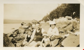
McManus family at Burrard Inlet
https://search.heritageburnaby.ca/link/museumdescription77
- Repository
- Burnaby Village Museum
- Date
- 1932
- Collection/Fonds
- Burnaby Village Museum Photograph collection
- Description Level
- Item
- Physical Description
- 1 photograph : sepia ; 6 x 10.5 cm
- Scope and Content
- Photograph of David and Bob and Ray McManus sitting on the rocks at the shore of the Burrard Inlet in their swimsuits with Jessie McManus who is wearing a light coloured jacket and hat. A house is visible in the background. The photograph was taken at the foot of Willingdon Avenue looking up the in…
- Repository
- Burnaby Village Museum
- Collection/Fonds
- Burnaby Village Museum Photograph collection
- Description Level
- Item
- Physical Description
- 1 photograph : sepia ; 6 x 10.5 cm
- Scope and Content
- Photograph of David and Bob and Ray McManus sitting on the rocks at the shore of the Burrard Inlet in their swimsuits with Jessie McManus who is wearing a light coloured jacket and hat. A house is visible in the background. The photograph was taken at the foot of Willingdon Avenue looking up the inlet towards Dollarton.
- Geographic Access
- Burrard Inlet
- Accession Code
- BV989.19.7
- Access Restriction
- No restrictions
- Reproduction Restriction
- No known restrictions
- Date
- 1932
- Media Type
- Photograph
- Scan Resolution
- 600
- Scan Date
- 01-Jun-09
- Scale
- 100
- Notes
- Title based on contents of photograph
- Note written in blue pen on verso of photograph reads: "Burrard Inlet 1932/ Bob + Jessie David Ray/ McMANUS/ Ft Willingdon Ave"
- Stamp on verso of photograph reads: "Vancouver Drug Co./ Ltd./ Nu-Gloss/ PHOTO FINISH"
Images

![Survey and Subdivision plans in New Westminster District Group 1 – Burnaby, [1905-1917] thumbnail](/media/hpo/_Data/_BVM_Cartographic_Material/1977/1977_0093_0022a_001.jpg?width=280)
Survey and Subdivision plans in New Westminster District Group 1 – Burnaby
https://search.heritageburnaby.ca/link/museumdescription6991
- Repository
- Burnaby Village Museum
- Date
- [1905-1917]
- Collection/Fonds
- Burnaby Village Museum Map collection
- Description Level
- File
- Physical Description
- 12 plans : 6 black ink on paper + 2 black & col. ink on paper + 4 graphite on paper
- Scope and Content
- Item consists of a large board of six New Westminster District subdivision plans mounted on one side and six New Westminster District subdivision plans mounted on the other side. Side A: 1. Plan drawn in graphite with markings in black ink "Surveyed for Mr. W. Wilson / Paterson Stat. B.C.E.R." . …
- Repository
- Burnaby Village Museum
- Collection/Fonds
- Burnaby Village Museum Map collection
- Description Level
- File
- Physical Description
- 12 plans : 6 black ink on paper + 2 black & col. ink on paper + 4 graphite on paper
- Material Details
- Scales [between 1:360 and 1:3168]
- Index number on edge of board reads: "22"
- Scope and Content
- Item consists of a large board of six New Westminster District subdivision plans mounted on one side and six New Westminster District subdivision plans mounted on the other side. Side A: 1. Plan drawn in graphite with markings in black ink "Surveyed for Mr. W. Wilson / Paterson Stat. B.C.E.R." . Plan includes subdivision of lots situated between B.C.E. Railway and Vancouver Road (Kingsway). (Geographic location: Burnaby) 2. Subdivision plan (no title) drawn in black ink with annotations in graphite. Plan covers District Lots 2, 4 and 6, west of North Road. Plan is stamped: "Albert J. Hill, Civil Engineer / and / Provincial Land Surveyor, / New Westminster, / B.C. (Geographic location: Burnaby) 3. Plan of "Portion of Municipality" with intials "RB" [sic] (handwritten in blue crayon). Plan covers the area north east of the City of New Westminster including District Lots 11, 13, 14, 12, 1 and 2. Plan is stamped: "Albert J. Hill, Civil Engineer / and / Provincial Land Surveyor, / New Westminster, / B.C. (Geographic location: Burnaby) 4."Plan / of Subdivision of / N.W.1/4 Lot 175 / Group 1 New West. Dist. / B.C. / Scale 4 chs = 1 in. " Plan is stamped: "Albert J. Hill, Civil Engineer / and / Provincial Land Surveyor, / New Westminster, / B.C. and initialed : "RB" [sic] (in blue pencil crayon) (Geographic location: Burnaby) 5. "Subdivision / of a Portion of / Lot 15 Group 1 / New Westminster Dist. / Scale 4 chs = 1 in". Plan provides numbered sudivisions - Lots 1 to 15 of District Lot 15 in red ink. (Geographic location: Burnaby) 6. Plan of "Central Park & / Vicinity" Plan includes subdivisions of District Lot 153 east of Central Park District Lot 151 and subdivision of District Lot 36 and 49 west of Boundary Road (Vancouver). Plan is stamped: "Albert J. Hill, Civil Engineer / and / Provincial Land Surveyor, / New Westminster, / B.C. and initialed : "RB" [sic] (in blue pencil crayon). (Geographic location: Burnaby) Side B: 1. Subdivision plan (no title) drawn in black ink. Plan identifies lots between Vancouver Road (Yale Road is crossed out and replaced with Vancouver Road) and B.C.E. Railway. "Scale 2 chs = 1 in" (Geographic location: Burnaby) 2. Plan of "Subdivision Lot 1 / Lot 69 Gr. 1 / Scale 30' = 1 " " Plan identifies Boundary Road, Still Creek and a Road Allowance between District Lot 118 and District Lot 69. Plan was "Surveyed for Burnaby Mun. Council / March 11th 1908 / G.K.B." (Geographic location: Burnaby) 3. Plan drawn in black ink (no title) showing a subdivision in Lot 25 with names "Newcomb", "Debeck" and "Armstrong" along with roads identified as Third Street, Cumberland Street, Armstrong Street and Cariboo [sic] Street and including Lots 27, 11 and 13.Plan is stamped: "Albert J. Hill, Civil Engineer / and / Provincial Land Surveyor, / New Westminster, / B.C. and initialed : "RB" [sic] (in blue pencil crayon). (Geographic location: Burnaby) 4. Handrawn subdivision plan in graphite titled: "Lot 13, Gr.1" with intials "RB" [sic] (handwritten in blue crayon). Plan is bordered by Armstrong Street (Lot 11, G.1), Cumberland St. (Lot 25, G.1) and Tenth Avenue (City Boundary). The plan is singed by "Albert J. Hill / P.L.S." and one of the subdivided lots is identified with the name: "W. Karrymann". (Geographic location: Burnaby) 5. Handrawn sketch in graphite titled: "Lot 88, Gr.1" with intials "RB" [sic] (handwritten in blue crayon). Plan appears to be a draft of a subdivision plan of a portion of District Lot 88 along Cumberland Road. The plan is signed: "16/7/17 _W.F. Draper [sic] / B.C.L.S." (Geographic location: Burnaby) 6. "Plan / of Subdivision / of Blocks 61, 62 and 2 / Lot 30 / Group 1 / N.W. Dist. / Scale 1ch = 1 in". Plan is intialed by: "PB" with a note: "Also see board 2 / for duplicate" (handwritten in blue crayon). (Geographic location: Burnaby)
- Creator
- Hill, Albert James
- Geographic Access
- Boundary Road
- Kingsway
- Cumberland Street
- Accession Code
- HV977.93.22
- Access Restriction
- No restrictions
- Reproduction Restriction
- No known restrictions
- Date
- [1905-1917]
- Media Type
- Cartographic Material
- Historic Neighbourhood
- Central Park (Historic Neighbourhood)
- Scan Resolution
- 300
- Scale
- 100
- Notes
- Title based on contents of file
- Scale is measured in chains and feet. (One chain equals 792 inches)
- The term "Lot" can also refer to a "District Lot”
- Some plans are stamped: "Albert J. Hill, Civil Engineer / and / Provincial Land Surveyor, / New Westminster, / B.C." and intialed: "RB" [sic]
Images
![Survey and Subdivision plans in New Westminster District Group 1 – Burnaby, [1905-1917] thumbnail](/media/hpo/_Data/_BVM_Cartographic_Material/1977/1977_0093_0022a_001.jpg)
