Narrow Results By
Subject
- Buildings - Industrial - Factories 1
- Buildings - Residential - Houses 1
- Education 1
- Events - Competitions 1
- Housing 1
- Industries - Forestry 1
- Industries - Logging/lumber 1
- Organizations 1
- Organizations - Girls' Societies and Clubs 2
- Performances 1
- Persons - South Asian Canadians 1
- Recreational Activities - Hiking 1
Person / Organization
- 5th Burnaby Brownie Pack 1
- Allard, Nancy Davis 1
- Bingham, Alfred "Alf" 1
- Canada Summer Games 1
- Citizens Against Transmission Towers 1
- Dominion Bridge Company 1
- Dullum, Denise Fouchard 2
- Friends of Simon 1
- Gilley Brothers Logging Company 1
- Girl Guides of Canada 2
- Kennedy, Marnie 2
- Neel, Kanwal Singh 1
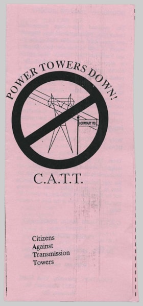
brochure
https://search.heritageburnaby.ca/link/museumartifact91856
- Repository
- Burnaby Village Museum
- Accession Code
- BV023.23.2
- Description
- Power Towers Down! - Brochure -- [1995]. Bifold brochure printed on pink paper from the Citizens Against Transmission Towers (C.A.T.T.) organization providing information on the history of the transmission towers on Boundary Road and why they should come down. The brochure has information about a public inquiry that was held on March 27 and 28 1995 at the Burnaby Villa Hotel.
- Object History
- The Citizens Against Transmission Towers (CATT) was a grassroots organization that was formed in 1994 by resident on either side of Boundary Road in Vancouver and Burnaby. The power lines were put up all along half of Boundary Road in 1948 as a result of an urgent need by Vancouver and Burnaby city councils. At the time, they were not built to the current (1990s) safety standards, as they were intended to be temporary. The group was concerned about the safety of the old structures as well as about the health concerns sometimes associated to power lines.
- Category
- 08. Communication Artifacts
- Classification
- Advertising Media
- Object Term
- Brochure
- Measurements
- Height: 22 cm
- Width: 10 cm
- Subjects
- Organizations
- Geographic Access
- Boundary Road
Images


Burnaby Mountain sod turning
https://search.heritageburnaby.ca/link/museumdescription11934
- Repository
- Burnaby Village Museum
- Date
- October 7, 1957 (date of original), digitized in 2020
- Collection/Fonds
- Burnaby Village Museum Film and Video collection
- Description Level
- Item
- Physical Description
- 1 film reel (1 min., 22 sec.) : acetate, b&w, silent ; 16 mm
- Scope and Content
- Item consists of a silent CBUT News item from October 7, 1957 titled "Burnaby Mountain Sod Turning". The film documents the memorable occasion of the Burnaby Mountain Centennial Project with Lieutenant Governor Frank M. Ross providing a brief address to the attendees before taking a shovel to turn…
- Repository
- Burnaby Village Museum
- Collection/Fonds
- Burnaby Village Museum Film and Video collection
- Description Level
- Item
- Physical Description
- 1 film reel (1 min., 22 sec.) : acetate, b&w, silent ; 16 mm
- Material Details
- Label around film container reads: "CBUT NEWS ITEM of October 7, 1957 "BURNABY MOUNTAIN SOD TURNING" ( Duncan) on permanent loan to Burnaby Centennial Comm."
- Scope and Content
- Item consists of a silent CBUT News item from October 7, 1957 titled "Burnaby Mountain Sod Turning". The film documents the memorable occasion of the Burnaby Mountain Centennial Project with Lieutenant Governor Frank M. Ross providing a brief address to the attendees before taking a shovel to turn the sod. Other attendees identified include, Councillor Sam Hughes of the Centennial Committee and British Columbia Recreation Minister, Honourable Earl C. Westwood. This event marks the development of a portion of Burnaby Mountain park including the erection of a Centennial building which opened in 1958. The film footage captures views of Burrard Inlet from the mountain top as well as newly erected roads on Burnaby mountain. According to the Burnaby Adverstiser (Vol. 25 No. 27 - October 10, 1957 p.1), Lieutenant Governor Frank M. Ross provided a brief address for the sod turning ceremony which is quoted; "What Burnaby has undertaken is not merely to celebrate the Centennial observance, but it has started something which will last down through the years and provide a lot of pleasure for future generations."
- History
- This event marks the beginning of a Centennial project to develop a park and erect a pavillion as part of the British Columbia Centennial in 1958. In October 1956, a Burnaby Centennial Committee was appointed to govern over the project with the Reeve and Council at the head of the committee. Councillor S.E. Hughes was appointed as Chairman and W.M. Morrison as Vice Chairman with the organizational structure to include the provision for Honorary Vice Chairman, secretary, treasurer, advisory staff and representative delegates from community groups and working committees. In September 1957, the Centennial Committee submitted detailed plans for a proposed building to be located on the Centennial site on Burnaby Mountain together with a recommendation to create a Building Committee as part of the Centennial Committee. In November 1957, the Burnaby Centennial Committee recommended that the new road from Badger Street and Hastings Street to the Burnaby Mountain site be named Centennial Way. January 1958, councillors Mather and Jamieson were appointed to the committee by council to replace former council members that were no longer in office. Councillor Mather was appointed as Vice Chairman. CBUT station was owned by CBC and was first broadcast on December 16, 1953. "In 1975, the CBC consolidated its Vancouver radio and television operations into one building. Prior to this, CBC's Vancouver radio properties – CBU (690 AM), CBU-FM (105.7) and CBUF-FM (97.7) – had operated from a separate studio facility at 701 Hornby Street, within the basement of the Hotel Vancouver. Together, those stations formed the basis of the Regional Broadcast Centre at 700 Hamilton Street, a few blocks east of its previous radio and television facilities.
- Responsibility
- Canadian Broadcasting Corporation
- Geographic Access
- Burnaby Mountain Conservation Area
- Accession Code
- HV971.30.2
- Access Restriction
- No restrictions
- Reproduction Restriction
- May be restricted by third party rights
- Date
- October 7, 1957 (date of original), digitized in 2020
- Media Type
- Moving Images
- Notes
- Transcribed title
- Copyright is held by CBC
Images

Video
Burnaby Mountain sod turning, October 7, 1957 (date of original), digitized in 2020
Burnaby Mountain sod turning, October 7, 1957 (date of original), digitized in 2020
https://search.heritageburnaby.ca/media/hpo/_Data/_BVM_Moving_Images/1971_0030_0002_001.mp4![Digney Film 4 - Lawn bowling at Central Park, [196-] (date of original), copied 2019 thumbnail](/media/hpo/_Data/_BVM_Moving_Images/2019_0018_0006_004.jpg?width=280)
Digney Film 4 - Lawn bowling at Central Park
https://search.heritageburnaby.ca/link/museumdescription10658
- Repository
- Burnaby Village Museum
- Date
- [196-] (date of original), copied 2019
- Collection/Fonds
- Digney Family fonds
- Description Level
- Item
- Physical Description
- 1 video recording (mp4) (2 min., 9 sec.) : digital, 23 fps, col., si.
- Scope and Content
- Film segment of unidentified women and men lawn bowling at Central Park in Burnaby. Buildings along Kingsway and Boundary Road are visible in the background.
- Repository
- Burnaby Village Museum
- Collection/Fonds
- Digney Family fonds
- Description Level
- Item
- Physical Description
- 1 video recording (mp4) (2 min., 9 sec.) : digital, 23 fps, col., si.
- Scope and Content
- Film segment of unidentified women and men lawn bowling at Central Park in Burnaby. Buildings along Kingsway and Boundary Road are visible in the background.
- Creator
- Digney, Andy
- Subjects
- Sports - Lawn Bowling
- Geographic Access
- Central Park
- Boundary Road
- Kingsway
- Accession Code
- BV019.18.6.4
- Access Restriction
- No restrictions
- Reproduction Restriction
- No known restrictions
- Date
- [196-] (date of original), copied 2019
- Media Type
- Moving Images
- Historic Neighbourhood
- Central Park (Historic Neighbourhood)
- Photographer
- Digney, Ernest Frank "Dig"
- Notes
- Title based on contents of film segment
- Film segment originates from digitized version of original 8 mm film (See BV019.18.6)
Images
![Digney Film 4 - Lawn bowling at Central Park, [196-] (date of original), copied 2019 thumbnail](/media/hpo/_Data/_BVM_Moving_Images/2019_0018_0006_004.jpg)
Video
Digney Film 4 - Lawn bowling at Central Park, [196-] (date of original), copied 2019
Digney Film 4 - Lawn bowling at Central Park, [196-] (date of original), copied 2019
https://search.heritageburnaby.ca/media/hpo/_Data/_BVM_Moving_Images/2019_0018_0006_004.mp4![Digney Film 4 - Lawn bowling at Central Park, [196-] (date of original), copied 2019 thumbnail](/media/hpo/_Data/_BVM_Moving_Images/2019_0018_0006_007.jpg?width=280)
Digney Film 4 - Lawn bowling at Central Park
https://search.heritageburnaby.ca/link/museumdescription10659
- Repository
- Burnaby Village Museum
- Date
- [196-] (date of original), copied 2019
- Collection/Fonds
- Digney Family fonds
- Description Level
- Item
- Physical Description
- 1 video recording (mp4) (3 min., 22 sec.) : digital, 23 fps, col., si.
- Scope and Content
- Film segment of women and men lawn bowling at Central Park in Burnaby. Buildings along Kingsway and Boundary Road are visible in the background. Sydney Swan (wearing glasses and vest) is identified as one of the bowlers.
- Repository
- Burnaby Village Museum
- Collection/Fonds
- Digney Family fonds
- Description Level
- Item
- Physical Description
- 1 video recording (mp4) (3 min., 22 sec.) : digital, 23 fps, col., si.
- Scope and Content
- Film segment of women and men lawn bowling at Central Park in Burnaby. Buildings along Kingsway and Boundary Road are visible in the background. Sydney Swan (wearing glasses and vest) is identified as one of the bowlers.
- Creator
- Digney, Andy
- Subjects
- Sports - Lawn Bowling
- Names
- Swan, Sydney
- Geographic Access
- Central Park
- Boundary Road
- Kingsway
- Accession Code
- BV019.18.6.7
- Access Restriction
- No restrictions
- Reproduction Restriction
- No known restrictions
- Date
- [196-] (date of original), copied 2019
- Media Type
- Moving Images
- Historic Neighbourhood
- Central Park (Historic Neighbourhood)
- Planning Study Area
- Maywood Area
- Photographer
- Digney, Ernest Frank "Dig"
- Notes
- Title based on contents of film segment
- Film segment originates from digitized version of original 8 mm film (See BV019.18.6)
- Similar footage of lawn bowling - see BV019.18.6.8
Images
![Digney Film 4 - Lawn bowling at Central Park, [196-] (date of original), copied 2019 thumbnail](/media/hpo/_Data/_BVM_Moving_Images/2019_0018_0006_007.jpg)
Video
Digney Film 4 - Lawn bowling at Central Park, [196-] (date of original), copied 2019
Digney Film 4 - Lawn bowling at Central Park, [196-] (date of original), copied 2019
https://search.heritageburnaby.ca/media/hpo/_Data/_BVM_Moving_Images/2019_0018_0006_007.mp4Dominion Bridge Company Limited - Burnaby Plant
https://search.heritageburnaby.ca/link/museumdescription17538
- Repository
- Burnaby Village Museum
- Date
- 29 Aug. 1957
- Collection/Fonds
- Burnaby Village Museum Map collection
- Description Level
- Item
- Physical Description
- 1 plan : col. lithographic print ; 50.5 x 84 cm
- Scope and Content
- Item consists of a fire insurance plan of the Dominion Bridge Company Burnaby Plant located on the east side of Boundary Road near Lougheed Highway. The plan is in two sheets mounted on a backing board. The buildings are located and colour coded. The plan includes profiles of the buildings. Title o…
- Repository
- Burnaby Village Museum
- Collection/Fonds
- Burnaby Village Museum Map collection
- Description Level
- Item
- Physical Description
- 1 plan : col. lithographic print ; 50.5 x 84 cm
- Material Details
- Scale [1:960]
- Scope and Content
- Item consists of a fire insurance plan of the Dominion Bridge Company Burnaby Plant located on the east side of Boundary Road near Lougheed Highway. The plan is in two sheets mounted on a backing board. The buildings are located and colour coded. The plan includes profiles of the buildings. Title on plan reads "DOMINION BRIDGE COMPANY, LIMITED / "BURNABY PLANT" / Burnaby, B.C.". The site plan was surveyed by C. L. Schwaab Jr.
- History
- Dominion Bridge Company was a major enterprise in Burnaby operating from the 1930 until the mid 1970s. Dominion Bridge constructed steel structures ranging from portions of the Golden Gate and Lions Gate Bridges to holding tanks for pulp mills. Beginning in the mid-1970s, unused areas of the site were used for filming on a temporary basis and in 1987 the site was established as a dedicated studio production facility named Bridge Studios.
- Creator
- Schwabb, C.L. Jr.
- Subjects
- Buildings - Industrial - Factories
- Names
- Dominion Bridge Company
- Responsibility
- Associated Factory Mutual Fire Insurance Cos
- Geographic Access
- Boundary Road
- Street Address
- 2400 Boundary Road
- Accession Code
- BV015.10.1
- Access Restriction
- Restricted access
- Reproduction Restriction
- May be restricted by third party rights
- Date
- 29 Aug. 1957
- Media Type
- Cartographic Material
- Historic Neighbourhood
- Broadview (Historic Neighbourhood)
- Planning Study Area
- West Central Valley Area
- Scan Resolution
- 400
- Scan Date
- 2021-11-28
- Notes
- Title based on contents of plan
- Scale on plan reads "1 inch = 80 ft / By V. Pitkin"
- Identfication information in bottom right corner of plan reads: "FACTORY MUTUAL ENGINEERING DIVISION / Associated Factory Mutual Fire Insurance Cos. / Norwood, Mass. / SERIAl 47330 / Replacing 35238 / INDEX 3994"
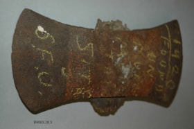
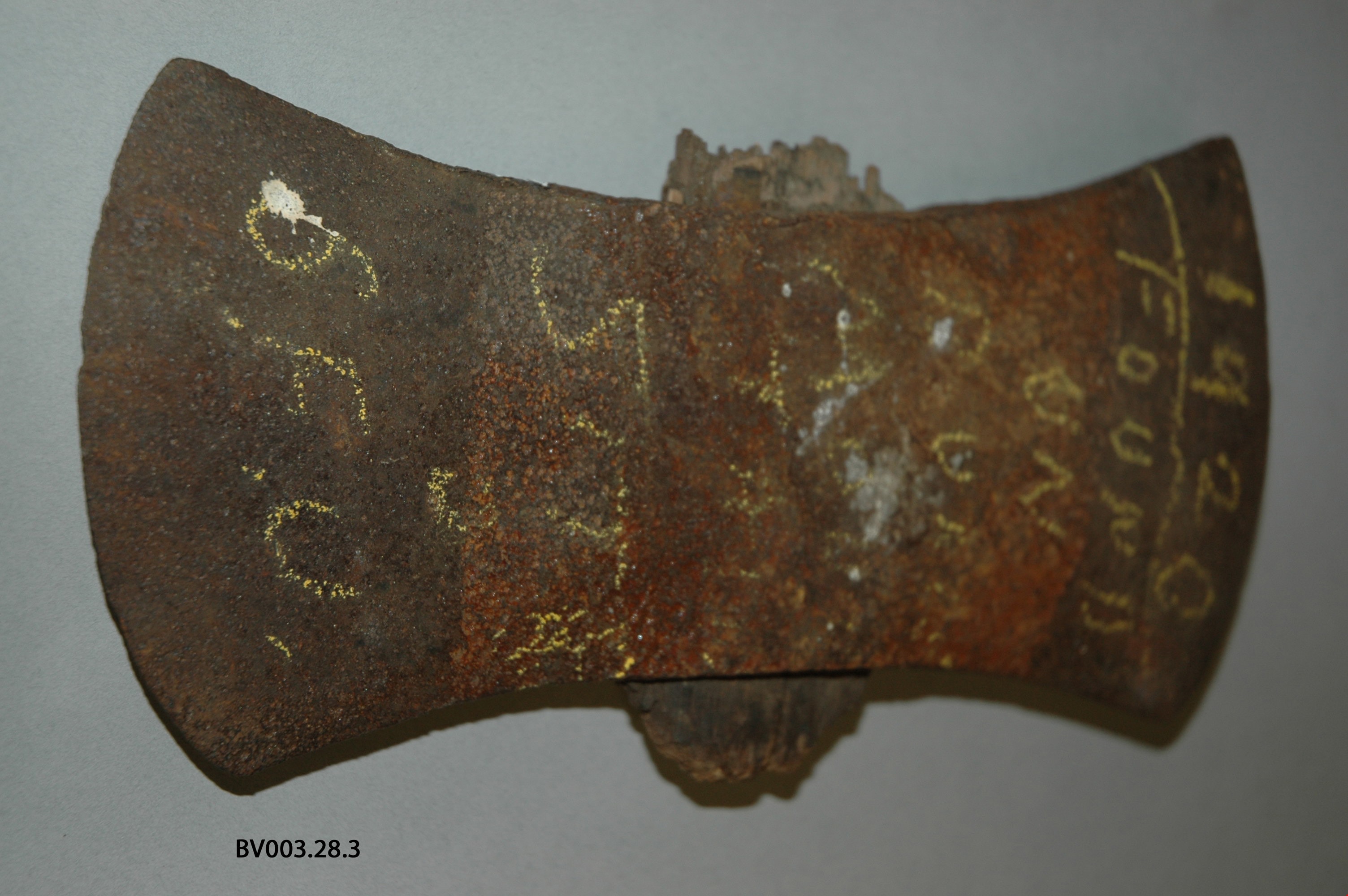
double bit axe head
https://search.heritageburnaby.ca/link/museumartifact45469
- Repository
- Burnaby Village Museum
- Accession Code
- BV003.28.3
- Description
- This split, double bitted, utility axe head was found on Burnaby Mountain by Alfred Bingham in 1920. Mr Bingham bought property on the West side of the mountain in 1920. The axe head is double bladed. The head is very rusty and has been cracked across one side. The remains of the handle are still in the axe eye.
- Object History
- The axe head was found on the site of Simon Fraser University (SFU), an area logged in the early years of the 20th Century by Gilley Logging. The axe may have been broken by one of their loggers.
- Reference
- Note from Alfred Bingham, original in accession file. "THIS AXE HEAD WAS FOUND IN 1920 / BY ALFRED BINGHAM ON THE PRESENT SITE / OF THE SIMON FRASER UNIVERSITY. IT PROBABLY / WAS USED BY AN EARLY LOGGER. WHO CUT DOWN / SOME OF THE GREAT TREES THAT GREW ON / BURNABY MOUNTAIN. HUNDREDS OF YEARS AGO. MANY OF THESE TREES WERE OVER 800 YEARS OLD / Alfred Bingham " hand written in ink on one face of note. "I bought 5 acres of stump land on the / corner of Sherlock, Duthie, & Kitchener Streets in / 1920. & cleared 2 acres & bilt small home, (store?) / my wife and I have lived in Burnaby continually since then / AB" hand written in ink on the reverse face of the note.
- Marks/Labels
- "1920 FOUND ON BURNABY MTN SITE S.F.U.", written in yellow chalk on one face of the axe head
- Geographic Access
- Burnaby Mountain Conservation Area
- Planning Study Area
- Burnaby Mountain Area
Images

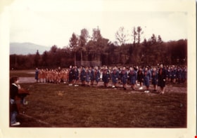
Girl guides on Burnaby mountain
https://search.heritageburnaby.ca/link/museumdescription15310
- Repository
- Burnaby Village Museum
- Date
- 1961
- Collection/Fonds
- Burnaby Girl Guides fonds
- Description Level
- Item
- Physical Description
- 1 photograph : col. ; 20.5 x 25.5 cm
- Scope and Content
- Photograph of a group of 5th Burnaby Brownies, Guides and their leaders from North Burnaby gathered together on Burnaby Mountain for the first outdoor "Scouts Own" and "Guides Own" Service since the early 1950s. Guides and Brownies from Burnaby Heights, Willingdon, HIllview and Sperling Guide Distr…
- Repository
- Burnaby Village Museum
- Collection/Fonds
- Burnaby Girl Guides fonds
- Description Level
- Item
- Physical Description
- 1 photograph : col. ; 20.5 x 25.5 cm
- Scope and Content
- Photograph of a group of 5th Burnaby Brownies, Guides and their leaders from North Burnaby gathered together on Burnaby Mountain for the first outdoor "Scouts Own" and "Guides Own" Service since the early 1950s. Guides and Brownies from Burnaby Heights, Willingdon, HIllview and Sperling Guide Districts and Rovers, Scouts and Cubs from Burnaby Heights, Burnaby Burrard and Burnaby Mountain Scout Districts gathered in the natural amphitheatre near the Pavillion, at two o'clock Sunday afternoon for the service.
- Geographic Access
- Burnaby Mountain Conservation Area
- Accession Code
- BV015.35.350
- Access Restriction
- No restrictions
- Reproduction Restriction
- May be restricted by third party rights
- Date
- 1961
- Media Type
- Photograph
- Planning Study Area
- Burnaby Mountain Area
- Scan Resolution
- 600
- Scan Date
- March 9, 2021
- Scale
- 100
- Notes
- Title based on contents of photograph
- Photograph is a part of original scrapbook "5th Brownie Pack" 1948-1965 Item BV015.35.156
- Information regarding event gathered from newspaper clipping with headline "Scouts, Guides / To Worship / Sunday Afternoon"
Images

![Home of Richard and Clara Thorpe, [1911] thumbnail](/media/hpo/_Data/_BVM_Images/1990/199900610001.jpg?width=280)
Home of Richard and Clara Thorpe
https://search.heritageburnaby.ca/link/museumdescription1507
- Repository
- Burnaby Village Museum
- Date
- [1911]
- Collection/Fonds
- Burnaby Village Museum Photograph collection
- Description Level
- Item
- Physical Description
- 1 photograph : b&w ; 10x 14 cm, mounted on card 15 x 22.5 cm
- Scope and Content
- Photograph of the home of Richard and Clara Thorpe. Nancy Davis Allard is standing, holding baby Dorothy Thorp (later Spain) upright in a buggy at the foot of the stairs. Two unidentified woman are also visible sitting at the top of the stairs.
- Repository
- Burnaby Village Museum
- Collection/Fonds
- Burnaby Village Museum Photograph collection
- Description Level
- Item
- Physical Description
- 1 photograph : b&w ; 10x 14 cm, mounted on card 15 x 22.5 cm
- Scope and Content
- Photograph of the home of Richard and Clara Thorpe. Nancy Davis Allard is standing, holding baby Dorothy Thorp (later Spain) upright in a buggy at the foot of the stairs. Two unidentified woman are also visible sitting at the top of the stairs.
- Subjects
- Buildings - Residential - Houses
- Geographic Access
- Boundary Road
- Burke Street
- Accession Code
- BV999.61.1
- Access Restriction
- No restrictions
- Date
- [1911]
- Media Type
- Photograph
- Historic Neighbourhood
- Central Park (Historic Neighbourhood)
- Planning Study Area
- Garden Village Area
- Scan Resolution
- 600
- Scan Date
- 09-Jun-09
- Scale
- 100
- Notes
- Title based on contents of photograph
- Note in blue ink on verso of photograph reads: "Home of Richard and/ Clara Thorp - about 1911./ Built in 1907. Boundary/ & Burke St. - Burnaby/ I'm in the buggy, held upright by my/ dear friend Nance -"
Images
![Home of Richard and Clara Thorpe, [1911] thumbnail](/media/hpo/_Data/_BVM_Images/1990/199900610001.jpg)
![Interview with Kanwal Singh Neel, [1973-2023] (interview content), interviewed 5 Jul. 2023 thumbnail](/media/hpo/_Data/_BVM_Sound_Recordings/Oral_Histories/2023_0016_0011_002.jpg?width=280)
Interview with Kanwal Singh Neel
https://search.heritageburnaby.ca/link/museumdescription19607
- Repository
- Burnaby Village Museum
- Date
- [1973-2023] (interview content), interviewed 5 Jul. 2023
- Collection/Fonds
- Burnaby Village Museum fonds
- Description Level
- Item
- Physical Description
- 1 video recording (mp4) (50 min., 32 sec.) : digital, col., sd., stereo ; 30 fps
- Scope and Content
- Item consists of a recording of an oral history interview with Kanwal Singh Neel conducted by Burnaby Village Museum Registrar, Rajdeep. The interview was conducted and recorded on the Zoom platform. 00:00 – 00:06:47 Kanwal shares some of the mentors that influenced him in his life, education and …
- Repository
- Burnaby Village Museum
- Collection/Fonds
- Burnaby Village Museum fonds
- Series
- Museum Oral Histories series
- Subseries
- Many Voices Project Interviews subseries
- Description Level
- Item
- Physical Description
- 1 video recording (mp4) (50 min., 32 sec.) : digital, col., sd., stereo ; 30 fps
- Material Details
- Interviewer: Rajdeep Interviewee: Kanwal Singh Neel Interview Date: July 5, 2023 Total Number of tracks: 1 Total Length of all Tracks: 50 min., 32 sec. Recording Device: Zoom video communication platform
- Scope and Content
- Item consists of a recording of an oral history interview with Kanwal Singh Neel conducted by Burnaby Village Museum Registrar, Rajdeep. The interview was conducted and recorded on the Zoom platform. 00:00 – 00:06:47 Kanwal shares some of the mentors that influenced him in his life, education and career, how his three-year grandson has been an inspiration and how important it is to educate yourself in different ways. 00:06:48 - 00:19:02 Kanwal talks about the diversity in the schools that he’s encountered over the years as a student and as an educator and shares his experiences getting hired as an educator on public television and being known as "the math guy". 00:19:03 - 00:46:39 Kanwal talks about the “Friends of Simon” tutoring out-reach program and his involvement. 00:26:40 - 00:30:24 Kanwal shares his experiences officiating the Canada Summer Games, the Harry Jerome Track Classic, the Commonwealth Games and other world class sporting events. 00:30:25 - 00:38:58 Kanwal describes a typical day while working at Simon Fraser University as Associate Director of Professional Programs, as a sports official and his involvement with Friends of Simon. Kanwal speaks about the importance of finding a balance between staying connected, finding your purpose and carrying on the passions that you enjoy. Kanwal talks about some of his favourite places in Burnaby including Simon Fraser University, Burnaby Mountain, Deer Lake and Central Park. 00:38:59 - 00:43:31 Kanwal talks about the changes that he’s seen in the lower mainland over his life time including; diminishing agricultural land, the fishing industry, public transportation, housing and retail infrastructure and homelessness. 00:43:32 - 00:50:32 Kanwal talks about his involvement with the Punjabi Cultural Association, the introduction of Punjabi language courses in public schools and his involvement in a Bhangra event. Kanwal imparts a final message to youth of today emphasizing the importance of, building relationships, giving back to your community, learning through education and being respectful of your own journey and others.
- History
- Interviewee biography: Kanwal Singh Neel was born in Mombasa, Kenya in 1953 and immigrated with his family to Canada in 1969. For the first few weeks after immigrating the family stayed at the Sikh Temple on Second Avenue before moving into a house which they rented. Kanwal attended Kitsilano Secondary School and later transferred to Steveston High School when his family moved to Richmond. In 1972, Kanwal and friends formed a bhangra group "Punjab Cultural Association" and in 1974 they performed at the World Exposition in Spokane, Washington. The group performed at various venues including the Pacific National Exhibition and other cities in the Province. In 1973, Kanwal was an officiate during the Canada Summer Games at Swangard Stadium in Burnaby. Kanwal obtained a Bachelor’s of Science Degree from University of British Columbia in computer science and mathematics and got his first teaching job in 1977. In 1978, he was an officiate of the Commonwealth Games in Edmonton, Alberta. Over the next ten years he devoted himself to becoming an educator and during this time he became more involved with the B.C. Math Teachers Association. Kanwal and his wife Nancy married in 1982 and have two daughters. In the early 1990's, Kanwal joined Simon Fraser University as a faculty associate to work, train and mentor student teachers. Kanwal became President of the B.C. Math Teachers Association and travelled throughout the province to help solve issues being faced by students. In 1993, he co-hosted a TV show "Math Shop" on The Knowledge Network and he later co-authored a textbook series titled "Math Makes Sense". Kanwal continued to advance his knowledge in the field of mathematics obtaining a Doctorate from Simon Fraser University in 2008. Kanwal developed his doctoral work in Haida Gwaii, studying the mathematics that the Haida peoples used in day to day life, applying the applications and integrating the mathematics concepts with their cultural knowledge. Kanwal also worked with the Sḵwx̱wú7mesh Nation and the Stó:lō Nation in helping to develop resources for them. Kanwal has been recognized with various awards and honours including being awarded an honorary doctorate by Kwantlen Polytechnic University and in 2017 as an inductee in the Sports Wall of Fame in Richmond for his outstanding contribution to amateur sport as an International Athletics Official. Since retirement, Kanwal continues to be involved in a project at Simon Fraser University "Friends of Simon" where university students go out and mentor and tutor immigrant and refugee children from South Asia and Africa and other countries. Interviewer biography: Rajdeep was born and raised in the Lower Mainland and is of Punjabi (South Asian) descent. She has an Associate of Arts degree in Asian Studies from Kwantlen Polytechnic University, a Bachelor of Arts (Hons.) in Anthropology from the University of British Columbia. She is a student in the Restoration of Natural Systems program at the University of Victoria. Rajdeep works at Simon Fraser University as a Program Assistant and as a researcher with the City of Burnaby. At Burnaby Village Museum, Rajdeep contributed to the exhibit “Truths Not Often Told: Being South Asian in Burnaby”.
- Creator
- Burnaby Village Museum
- Subjects
- Persons - South Asian Canadians
- Education
- Social Issues
- Social Issues - Racism
- Sports
- Events - Competitions
- Housing
- Performances
- Names
- Neel, Kanwal Singh
- Simon Fraser University
- Friends of Simon
- Canada Summer Games
- Swangard Stadium
- Punjabi Cultural Association
- Responsibility
- Rajdeep
- Geographic Access
- Burnaby Mountain Conservation Area
- Central Park
- Accession Code
- BV023.16.11
- Date
- [1973-2023] (interview content), interviewed 5 Jul. 2023
- Media Type
- Moving Images
- Notes
- Title based on contents of item
Images
![Interview with Kanwal Singh Neel, [1973-2023] (interview content), interviewed 5 Jul. 2023 thumbnail](/media/hpo/_Data/_BVM_Sound_Recordings/Oral_Histories/2023_0016_0011_002.jpg)
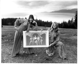
Mountain mural for Canada Summer Games
https://search.heritageburnaby.ca/link/museumdescription18818
- Repository
- Burnaby Village Museum
- Date
- 1972
- Collection/Fonds
- Denise Dullum fonds
- Description Level
- Item
- Physical Description
- 1 photograph : b&w ; 20.5 x 25 cm
- Scope and Content
- Photograph of Marnie Kennedy (left) and Denise Fouchard (Dullum) (right) on Burnaby Mountain posing with a rendering of the Canada Summer Games Sports Mural by Ken Rainford. The artwork was designed to become a twenty foot by thirty foot mural constructed of mosaic tiles when the 1973 Games are com…
- Repository
- Burnaby Village Museum
- Collection/Fonds
- Denise Dullum fonds
- Description Level
- Item
- Physical Description
- 1 photograph : b&w ; 20.5 x 25 cm
- Scope and Content
- Photograph of Marnie Kennedy (left) and Denise Fouchard (Dullum) (right) on Burnaby Mountain posing with a rendering of the Canada Summer Games Sports Mural by Ken Rainford. The artwork was designed to become a twenty foot by thirty foot mural constructed of mosaic tiles when the 1973 Games are completed as a permanent momento to the event. The thousands of tiles were planned to make up the mural and were planned to be sold as a Summer Games fundraising project. Photograph appeared in a news article in The Columbian newspaper Nov. 24, 1972 with caption "GET WITH THE GAMES" as well as a news supplement "Canada Games Countdown" Vol. 1, No.1, December 1972 with caption on front page "A Mountain Mural". Marnie and Denise are dressed in "Canda Gamebirds" ensembles that were designed by Eaton's fashion department. Ensembles in the photograph consist of long sleeve striped shirts and ties, matching wide leg pants with a short plain coloured vest over top.
- Subjects
- Sports
- Geographic Access
- Burnaby Mountain Conservation Area
- Accession Code
- BV022.17.22
- Access Restriction
- No restrictions
- Reproduction Restriction
- May be restricted by third party rights
- Date
- 1972
- Media Type
- Photograph
- Planning Study Area
- Burnaby Mountain Area
- Scan Resolution
- 600
- Scan Date
- 2022-07-04
- Photographer
- King, Basil
- Notes
- Title based on contents of photograph
- Stamp in blue ink on verso of photograph reads "BASIL KING PHOTO"
- Handwritten note in pencil on verso of photograph reads: "The Columbian"
Images


Mountain mural for Canada Summer Games
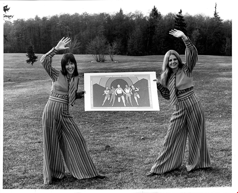
https://search.heritageburnaby.ca/link/museumdescription18819
- Repository
- Burnaby Village Museum
- Date
- 1973
- Collection/Fonds
- Denise Dullum fonds
- Description Level
- Item
- Physical Description
- 1 photograph : b&w ; 20.5 x 25 cm
- Scope and Content
- Photograph of Marnie Kennedy (left) and Denise Fouchard (Dullum) (right) on Burnaby Mountain posing with a rendering of the Canada Summer Games Sports Mural by Ken Rainford. The artwork was designed to become a twenty foot by thirty foot mural constructed of mosaic tiles when the 1973 Games are com…
- Repository
- Burnaby Village Museum
- Collection/Fonds
- Denise Dullum fonds
- Description Level
- Item
- Physical Description
- 1 photograph : b&w ; 20.5 x 25 cm
- Scope and Content
- Photograph of Marnie Kennedy (left) and Denise Fouchard (Dullum) (right) on Burnaby Mountain posing with a rendering of the Canada Summer Games Sports Mural by Ken Rainford. The artwork was designed to become a twenty foot by thirty foot mural constructed of mosaic tiles when the 1973 Games are completed as a permanent momento to the event. The thousands of tiles were planned to make up the mural and were planned to be sold as a Summer Games fundraising project. Photograph appeared in a news article in The Columbian newspaper Nov. 24, 1972 with caption "GET WITH THE GAMES" as well as a news supplement "Canada Games Countdown" Vol. 1, No.1, December 1972 with caption on front page "A Mountain Mural". Marnie and Denise are dressed in "Canda Gamebirds" ensembles that were designed by Eaton's fashion department. Ensembles in the photograph consist of long sleeve striped shirts and ties, matching wide leg pants with a short plain coloured vest over top.
- Subjects
- Sports
- Geographic Access
- Burnaby Mountain Conservation Area
- Accession Code
- BV022.17.23
- Access Restriction
- No restrictions
- Reproduction Restriction
- May be restricted by third party rights
- Date
- 1973
- Media Type
- Photograph
- Planning Study Area
- Burnaby Mountain Area
- Scan Resolution
- 600
- Scan Date
- 2022-07-04
- Photographer
- King, Basil
- Notes
- Title based on contents of photograph
- Stamp in blue ink on verso of photograph reads "BASIL KING PHOTO"
Images
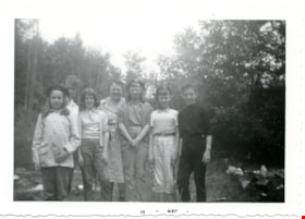
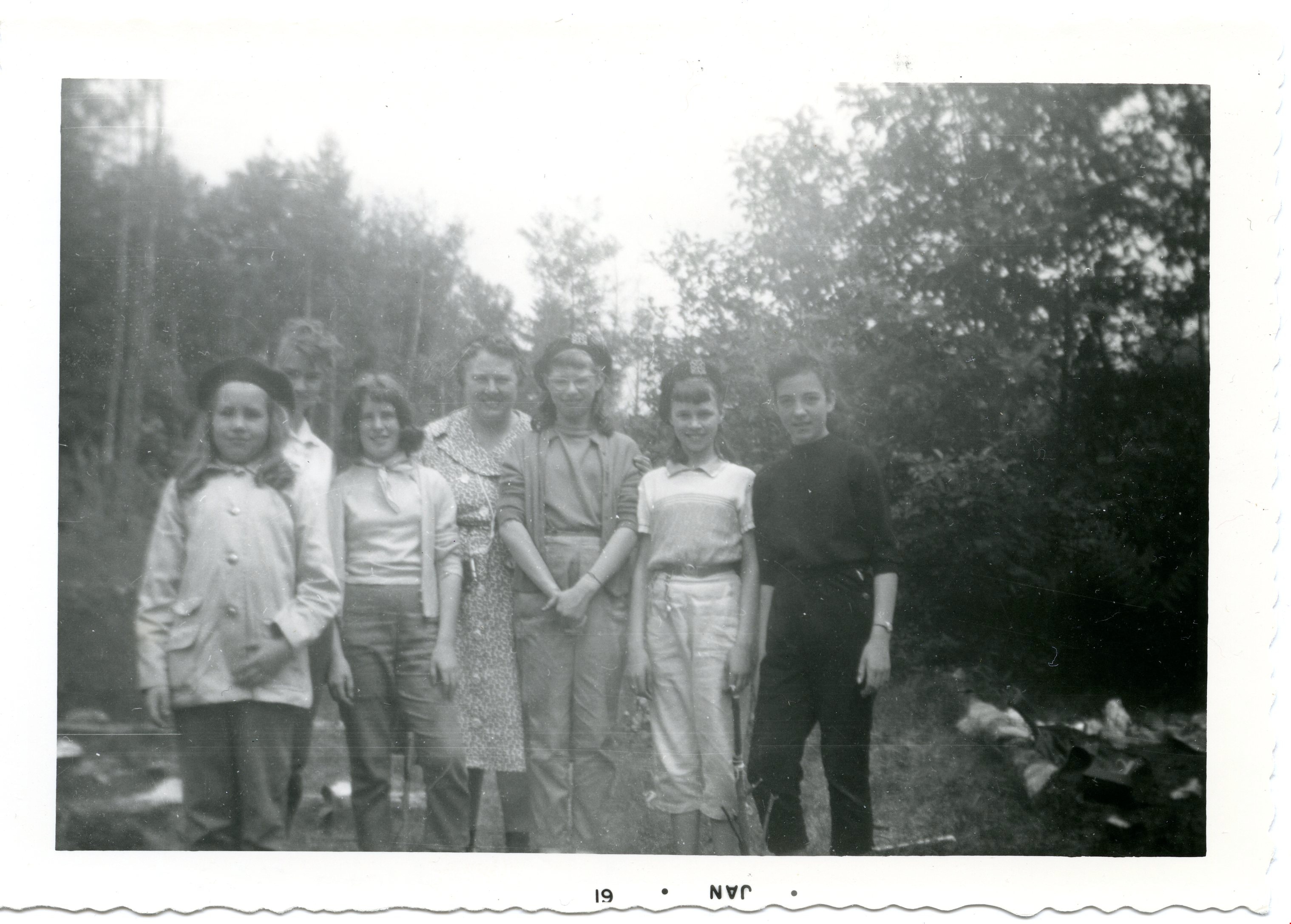
Patrol hike- Burnaby Mountain
https://search.heritageburnaby.ca/link/museumdescription4957
- Repository
- Burnaby Village Museum
- Date
- Jan 1960
- Collection/Fonds
- Burnaby Girl Guides fonds
- Description Level
- Item
- Physical Description
- 1 photograph : b&w ; 9 x 13 cm
- Scope and Content
- Photograph of members of the 42nd Burnaby Girl Guide Company on a Patrol Hike on Burnaby Mountain. The woman in the centre of the photograph is Captain Vera Armstrong. Second from the left is Irene Armstrong. Second from the right is Linda Chesley.
- Repository
- Burnaby Village Museum
- Collection/Fonds
- Burnaby Girl Guides fonds
- Description Level
- Item
- Physical Description
- 1 photograph : b&w ; 9 x 13 cm
- Material Details
- Handwritten text in blue ink on back of photograph reads: "Ada Thomas / Rosalind Caiswell / Maureen Hollingsworth / Shaun [illegible] / Irene Armstrong / Linda Chesley / Hike / 1960 / Burnaby / Mtn.".
- Photograph is date stamped in bottom margin as "JAN * 61".
- Scope and Content
- Photograph of members of the 42nd Burnaby Girl Guide Company on a Patrol Hike on Burnaby Mountain. The woman in the centre of the photograph is Captain Vera Armstrong. Second from the left is Irene Armstrong. Second from the right is Linda Chesley.
- Names
- Girl Guides of Canada
- Geographic Access
- Burnaby Mountain Conservation Area
- Accession Code
- BV015.35.190
- Access Restriction
- No restrictions
- Reproduction Restriction
- May be restricted by third party rights
- Date
- Jan 1960
- Media Type
- Photograph
- Planning Study Area
- Burnaby Mountain Area
- Notes
- Title based on content
- Photograph is a part of Photograph album BV015.35.158
Images
![Survey and Subdivision plans in New Westminster District Group 1 – Burnaby, [1905-1917] thumbnail](/media/hpo/_Data/_BVM_Cartographic_Material/1977/1977_0093_0022a_001.jpg?width=280)
Survey and Subdivision plans in New Westminster District Group 1 – Burnaby
https://search.heritageburnaby.ca/link/museumdescription6991
- Repository
- Burnaby Village Museum
- Date
- [1905-1917]
- Collection/Fonds
- Burnaby Village Museum Map collection
- Description Level
- File
- Physical Description
- 12 plans : 6 black ink on paper + 2 black & col. ink on paper + 4 graphite on paper
- Scope and Content
- Item consists of a large board of six New Westminster District subdivision plans mounted on one side and six New Westminster District subdivision plans mounted on the other side. Side A: 1. Plan drawn in graphite with markings in black ink "Surveyed for Mr. W. Wilson / Paterson Stat. B.C.E.R." . …
- Repository
- Burnaby Village Museum
- Collection/Fonds
- Burnaby Village Museum Map collection
- Description Level
- File
- Physical Description
- 12 plans : 6 black ink on paper + 2 black & col. ink on paper + 4 graphite on paper
- Material Details
- Scales [between 1:360 and 1:3168]
- Index number on edge of board reads: "22"
- Scope and Content
- Item consists of a large board of six New Westminster District subdivision plans mounted on one side and six New Westminster District subdivision plans mounted on the other side. Side A: 1. Plan drawn in graphite with markings in black ink "Surveyed for Mr. W. Wilson / Paterson Stat. B.C.E.R." . Plan includes subdivision of lots situated between B.C.E. Railway and Vancouver Road (Kingsway). (Geographic location: Burnaby) 2. Subdivision plan (no title) drawn in black ink with annotations in graphite. Plan covers District Lots 2, 4 and 6, west of North Road. Plan is stamped: "Albert J. Hill, Civil Engineer / and / Provincial Land Surveyor, / New Westminster, / B.C. (Geographic location: Burnaby) 3. Plan of "Portion of Municipality" with intials "RB" [sic] (handwritten in blue crayon). Plan covers the area north east of the City of New Westminster including District Lots 11, 13, 14, 12, 1 and 2. Plan is stamped: "Albert J. Hill, Civil Engineer / and / Provincial Land Surveyor, / New Westminster, / B.C. (Geographic location: Burnaby) 4."Plan / of Subdivision of / N.W.1/4 Lot 175 / Group 1 New West. Dist. / B.C. / Scale 4 chs = 1 in. " Plan is stamped: "Albert J. Hill, Civil Engineer / and / Provincial Land Surveyor, / New Westminster, / B.C. and initialed : "RB" [sic] (in blue pencil crayon) (Geographic location: Burnaby) 5. "Subdivision / of a Portion of / Lot 15 Group 1 / New Westminster Dist. / Scale 4 chs = 1 in". Plan provides numbered sudivisions - Lots 1 to 15 of District Lot 15 in red ink. (Geographic location: Burnaby) 6. Plan of "Central Park & / Vicinity" Plan includes subdivisions of District Lot 153 east of Central Park District Lot 151 and subdivision of District Lot 36 and 49 west of Boundary Road (Vancouver). Plan is stamped: "Albert J. Hill, Civil Engineer / and / Provincial Land Surveyor, / New Westminster, / B.C. and initialed : "RB" [sic] (in blue pencil crayon). (Geographic location: Burnaby) Side B: 1. Subdivision plan (no title) drawn in black ink. Plan identifies lots between Vancouver Road (Yale Road is crossed out and replaced with Vancouver Road) and B.C.E. Railway. "Scale 2 chs = 1 in" (Geographic location: Burnaby) 2. Plan of "Subdivision Lot 1 / Lot 69 Gr. 1 / Scale 30' = 1 " " Plan identifies Boundary Road, Still Creek and a Road Allowance between District Lot 118 and District Lot 69. Plan was "Surveyed for Burnaby Mun. Council / March 11th 1908 / G.K.B." (Geographic location: Burnaby) 3. Plan drawn in black ink (no title) showing a subdivision in Lot 25 with names "Newcomb", "Debeck" and "Armstrong" along with roads identified as Third Street, Cumberland Street, Armstrong Street and Cariboo [sic] Street and including Lots 27, 11 and 13.Plan is stamped: "Albert J. Hill, Civil Engineer / and / Provincial Land Surveyor, / New Westminster, / B.C. and initialed : "RB" [sic] (in blue pencil crayon). (Geographic location: Burnaby) 4. Handrawn subdivision plan in graphite titled: "Lot 13, Gr.1" with intials "RB" [sic] (handwritten in blue crayon). Plan is bordered by Armstrong Street (Lot 11, G.1), Cumberland St. (Lot 25, G.1) and Tenth Avenue (City Boundary). The plan is singed by "Albert J. Hill / P.L.S." and one of the subdivided lots is identified with the name: "W. Karrymann". (Geographic location: Burnaby) 5. Handrawn sketch in graphite titled: "Lot 88, Gr.1" with intials "RB" [sic] (handwritten in blue crayon). Plan appears to be a draft of a subdivision plan of a portion of District Lot 88 along Cumberland Road. The plan is signed: "16/7/17 _W.F. Draper [sic] / B.C.L.S." (Geographic location: Burnaby) 6. "Plan / of Subdivision / of Blocks 61, 62 and 2 / Lot 30 / Group 1 / N.W. Dist. / Scale 1ch = 1 in". Plan is intialed by: "PB" with a note: "Also see board 2 / for duplicate" (handwritten in blue crayon). (Geographic location: Burnaby)
- Creator
- Hill, Albert James
- Geographic Access
- Boundary Road
- Kingsway
- Cumberland Street
- Accession Code
- HV977.93.22
- Access Restriction
- No restrictions
- Reproduction Restriction
- No known restrictions
- Date
- [1905-1917]
- Media Type
- Cartographic Material
- Historic Neighbourhood
- Central Park (Historic Neighbourhood)
- Scan Resolution
- 300
- Scale
- 100
- Notes
- Title based on contents of file
- Scale is measured in chains and feet. (One chain equals 792 inches)
- The term "Lot" can also refer to a "District Lot”
- Some plans are stamped: "Albert J. Hill, Civil Engineer / and / Provincial Land Surveyor, / New Westminster, / B.C." and intialed: "RB" [sic]
Images
![Survey and Subdivision plans in New Westminster District Group 1 – Burnaby, [1905-1917] thumbnail](/media/hpo/_Data/_BVM_Cartographic_Material/1977/1977_0093_0022a_001.jpg)
