Narrow Results By
Subject
- Advertising Medium - Signs and Signboards 3
- Aerial Photographs 2
- Buildings - Commercial 5
- Buildings - Commercial - Offices 4
- Buildings - Heritage 1
- Buildings - Schools 2
- Construction - Road Construction 1
- Events - Royal Visits 1
- Geographic Features - Automobile Parking Lots 1
- Geographic Features - Parks 1
- Geographic Features - Roads 4
- Land Clearing 1

BC Tel Building
https://search.heritageburnaby.ca/link/archivedescription93609
- Repository
- City of Burnaby Archives
- Date
- October 16, 1977
- Collection/Fonds
- Burnaby Public Library Contemporary Visual Archive Project
- Description Level
- Item
- Physical Description
- 1 photograph : b&w ; 12.5 x 17.5 cm
- Scope and Content
- Photograph of the BC Tel Building (now the Brian Canfield Centre), located at Kingsway and Boundary Road. The photograph is taken facing north and shows the pedestrian overpass over Kingsway and the mountains in the background.
- Repository
- City of Burnaby Archives
- Date
- October 16, 1977
- Collection/Fonds
- Burnaby Public Library Contemporary Visual Archive Project
- Physical Description
- 1 photograph : b&w ; 12.5 x 17.5 cm
- Description Level
- Item
- Record No.
- 556-566
- Access Restriction
- No restrictions
- Reproduction Restriction
- Reproduce for fair dealing purposes only
- Accession Number
- 2017-57
- Scope and Content
- Photograph of the BC Tel Building (now the Brian Canfield Centre), located at Kingsway and Boundary Road. The photograph is taken facing north and shows the pedestrian overpass over Kingsway and the mountains in the background.
- Media Type
- Photograph
- Photographer
- McGillivray, Don
- Notes
- Title taken from project information form
- Accompanied by a project information form and 1 photograph (b&w negative ; 9.5 x 12.5 cm)
- BPL no. 10
- Geographic Access
- Boundary Road
- Kingsway
- Street Address
- 3777 Kingsway
- Historic Neighbourhood
- Central Park (Historic Neighbourhood)
- Planning Study Area
- Garden Village Area
Images


BC Tel Building
https://search.heritageburnaby.ca/link/archivedescription93678
- Repository
- City of Burnaby Archives
- Date
- June 4, 1978
- Collection/Fonds
- Burnaby Public Library Contemporary Visual Archive Project
- Description Level
- Item
- Physical Description
- 1 photograph : b&w ; 17.5 x 12.5 cm
- Scope and Content
- Photograph of the exterior of the BC Tel Building, located at Kingsway and Boundary Road, and the lawn and roads in front of the building. The photograph is taken from a high point across the intersection, facing southeast.
- Repository
- City of Burnaby Archives
- Date
- June 4, 1978
- Collection/Fonds
- Burnaby Public Library Contemporary Visual Archive Project
- Physical Description
- 1 photograph : b&w ; 17.5 x 12.5 cm
- Description Level
- Item
- Record No.
- 556-635
- Access Restriction
- No restrictions
- Reproduction Restriction
- Reproduce for fair dealing purposes only
- Accession Number
- 2017-57
- Scope and Content
- Photograph of the exterior of the BC Tel Building, located at Kingsway and Boundary Road, and the lawn and roads in front of the building. The photograph is taken from a high point across the intersection, facing southeast.
- Subjects
- Buildings - Commercial - Offices
- Media Type
- Photograph
- Photographer
- Chapman, Fred
- Notes
- Title taken from project information form
- Accompanied by a project information form and 1 photograph (b&w negative ; 12.5 x 9.5 cm)
- BPL no. 84
- Geographic Access
- Boundary Road
- Kingsway
- Street Address
- 3777 Kingsway
- Historic Neighbourhood
- Central Park (Historic Neighbourhood)
- Planning Study Area
- Garden Village Area
Images


BC Tel Building
https://search.heritageburnaby.ca/link/archivedescription93679
- Repository
- City of Burnaby Archives
- Date
- June 4, 1978
- Collection/Fonds
- Burnaby Public Library Contemporary Visual Archive Project
- Description Level
- Item
- Physical Description
- 1 photograph : b&w ; 12.5 x 17.5 cm
- Scope and Content
- Photograph of the exterior of the BC Tel Building, located at Kingsway and Boundary Road. The photograph is taken from across a lawn and railway tracks, facing southeast. The railway tracks are visible in the bottom left corner of the photograph.
- Repository
- City of Burnaby Archives
- Date
- June 4, 1978
- Collection/Fonds
- Burnaby Public Library Contemporary Visual Archive Project
- Physical Description
- 1 photograph : b&w ; 12.5 x 17.5 cm
- Description Level
- Item
- Record No.
- 556-636
- Access Restriction
- No restrictions
- Reproduction Restriction
- Reproduce for fair dealing purposes only
- Accession Number
- 2017-57
- Scope and Content
- Photograph of the exterior of the BC Tel Building, located at Kingsway and Boundary Road. The photograph is taken from across a lawn and railway tracks, facing southeast. The railway tracks are visible in the bottom left corner of the photograph.
- Media Type
- Photograph
- Photographer
- Chapman, Fred
- Notes
- Title taken from project information form
- Accompanied by a project information form and 1 photograph (b&w negative ; 9.5 x 12.5 cm)
- BPL no. 85
- Geographic Access
- Boundary Road
- Kingsway
- Street Address
- 3777 Kingsway
- Historic Neighbourhood
- Central Park (Historic Neighbourhood)
- Planning Study Area
- Garden Village Area
Images


BC Tel Building
https://search.heritageburnaby.ca/link/archivedescription93680
- Repository
- City of Burnaby Archives
- Date
- June 4, 1978
- Collection/Fonds
- Burnaby Public Library Contemporary Visual Archive Project
- Description Level
- Item
- Physical Description
- 1 photograph : b&w ; 12.5 x 17.5 cm
- Scope and Content
- Photograph of the exterior of the BC Tel Building, located at Kingsway and Boundary Road, and the lawn and neighbourhood surrounding the building. The photograph is taken from across the lawn, facing north. Boundary Road is on the left side of the photograph and the mountains are visible in the bac…
- Repository
- City of Burnaby Archives
- Date
- June 4, 1978
- Collection/Fonds
- Burnaby Public Library Contemporary Visual Archive Project
- Physical Description
- 1 photograph : b&w ; 12.5 x 17.5 cm
- Description Level
- Item
- Record No.
- 556-637
- Access Restriction
- No restrictions
- Reproduction Restriction
- Reproduce for fair dealing purposes only
- Accession Number
- 2017-57
- Scope and Content
- Photograph of the exterior of the BC Tel Building, located at Kingsway and Boundary Road, and the lawn and neighbourhood surrounding the building. The photograph is taken from across the lawn, facing north. Boundary Road is on the left side of the photograph and the mountains are visible in the background.
- Media Type
- Photograph
- Photographer
- Chapman, Fred
- Notes
- Title taken from project information form
- Accompanied by a project information form and 1 photograph (b&w negative ; 9.5 x 12.5 cm)
- BPL no. 86
- Geographic Access
- Kingsway
- Boundary Road
- Street Address
- 3777 Kingsway
- Historic Neighbourhood
- Central Park (Historic Neighbourhood)
- Planning Study Area
- Garden Village Area
Images


Boundary Road
https://search.heritageburnaby.ca/link/archivedescription79966
- Repository
- City of Burnaby Archives
- Date
- September 27, 1976
- Collection/Fonds
- Burnaby Public Library Contemporary Visual Archive Project
- Description Level
- Item
- Physical Description
- 1 photograph : b&w ; 11 x 16 cm mounted on cardboard
- Scope and Content
- Photograph shows a view of Boundary Road looking south from the railway trestle just north of Kingsway.
- Repository
- City of Burnaby Archives
- Date
- September 27, 1976
- Collection/Fonds
- Burnaby Public Library Contemporary Visual Archive Project
- Physical Description
- 1 photograph : b&w ; 11 x 16 cm mounted on cardboard
- Description Level
- Item
- Record No.
- 556-529
- Access Restriction
- No restrictions
- Reproduction Restriction
- Reproduce for fair dealing purposes only
- Accession Number
- 2013-13
- Scope and Content
- Photograph shows a view of Boundary Road looking south from the railway trestle just north of Kingsway.
- Subjects
- Aerial Photographs
- Media Type
- Photograph
- Photographer
- Norton, Paul
- Notes
- Scope note taken directly from BPL photograph description.
- 1 b&w copy negative : 10 x 12.5 cm accompanying
- Geographic Access
- Boundary Road
- Historic Neighbourhood
- Central Park (Historic Neighbourhood)
- Planning Study Area
- Garden Village Area
Images


Boundary Road
https://search.heritageburnaby.ca/link/archivedescription79967
- Repository
- City of Burnaby Archives
- Date
- September 27, 1976
- Collection/Fonds
- Burnaby Public Library Contemporary Visual Archive Project
- Description Level
- Item
- Physical Description
- 1 photograph : b&w ; 11 x 16 cm mounted on cardboard
- Scope and Content
- Photograph shows a view of Boundary Road looking north from the railway trestle just north of Kingsway.
- Repository
- City of Burnaby Archives
- Date
- September 27, 1976
- Collection/Fonds
- Burnaby Public Library Contemporary Visual Archive Project
- Physical Description
- 1 photograph : b&w ; 11 x 16 cm mounted on cardboard
- Description Level
- Item
- Record No.
- 556-530
- Access Restriction
- No restrictions
- Reproduction Restriction
- Reproduce for fair dealing purposes only
- Accession Number
- 2013-13
- Scope and Content
- Photograph shows a view of Boundary Road looking north from the railway trestle just north of Kingsway.
- Subjects
- Aerial Photographs
- Media Type
- Photograph
- Photographer
- Norton, Paul
- Notes
- Scope note taken directly from BPL photograph description.
- 1 b&w copy negative : 10 x 12.5 cm accompanying
- Geographic Access
- Boundary Road
- Historic Neighbourhood
- Central Park (Historic Neighbourhood)
- Planning Study Area
- Garden Village Area
Images

![Boundary Road and Kingsway, [1959] thumbnail](/media/Hpo/_Data/_Archives_Images/_Unrestricted/001/113-001.jpg?width=280)
Boundary Road and Kingsway
https://search.heritageburnaby.ca/link/archivedescription34709
- Repository
- City of Burnaby Archives
- Date
- [1959]
- Collection/Fonds
- Burnaby Historical Society fonds
- Description Level
- Item
- Physical Description
- 1 photograph : b&w ; 16.0 x 25.3 cm
- Scope and Content
- Photograph of buildings at Boundary Road and Kingsway, southwest corner. A typed description on the back of the photograph reads, "The new Hemlock (automatic) and old Dexter (manual) exchanges. / B.C. Telephone Company."
- Repository
- City of Burnaby Archives
- Date
- [1959]
- Collection/Fonds
- Burnaby Historical Society fonds
- Subseries
- Photographs subseries
- Physical Description
- 1 photograph : b&w ; 16.0 x 25.3 cm
- Description Level
- Item
- Record No.
- 113-001
- Access Restriction
- No restrictions
- Reproduction Restriction
- Reproduce for fair dealing purposes only
- Accession Number
- BHS2007-04
- Scope and Content
- Photograph of buildings at Boundary Road and Kingsway, southwest corner. A typed description on the back of the photograph reads, "The new Hemlock (automatic) and old Dexter (manual) exchanges. / B.C. Telephone Company."
- Media Type
- Photograph
- Photographer
- Williams Brothers Photographers Limited
- Notes
- Title based on contents of photograph
- Stamp on back of photograph reads, "Williams Bros. Photographers Ltd. / 413 Granville St. Vancouver 2, B.C. / Phone Tatlow 8588"
- Geographic Access
- Boundary Road
- Kingsway
- Historic Neighbourhood
- Central Park (Historic Neighbourhood)
- Planning Study Area
- Garden Village Area
Images
![Boundary Road and Kingsway, [1959] thumbnail](/media/Hpo/_Data/_Archives_Images/_Unrestricted/001/113-001.jpg)

Boundary Road and Park Avenue station
https://search.heritageburnaby.ca/link/archivedescription36670
- Repository
- City of Burnaby Archives
- Date
- 1912 (date of original), copied 1992
- Collection/Fonds
- Burnaby Historical Society fonds
- Description Level
- Item
- Physical Description
- 1 photograph : b&w ; 10.1 x 14.9 cm print
- Scope and Content
- Photograph of Boundary Road, Park Avenue Interurban station, and the surrounding area, looking north from Kingsway. The Coburn house, built in 1906, is at the top of the hill on the right, current address 5170 Boundary Road.
- Repository
- City of Burnaby Archives
- Date
- 1912 (date of original), copied 1992
- Collection/Fonds
- Burnaby Historical Society fonds
- Subseries
- Burnaby Centennial Anthology subseries
- Physical Description
- 1 photograph : b&w ; 10.1 x 14.9 cm print
- Description Level
- Item
- Record No.
- 315-025
- Access Restriction
- No restrictions
- Reproduction Restriction
- No known restrictions
- Accession Number
- BHS1994-04
- Scope and Content
- Photograph of Boundary Road, Park Avenue Interurban station, and the surrounding area, looking north from Kingsway. The Coburn house, built in 1906, is at the top of the hill on the right, current address 5170 Boundary Road.
- Media Type
- Photograph
- Notes
- Title based on contents of photograph
- Annotation at bottom of photograph reads; "Boundary Rd and Park Ave Station"
- Geographic Access
- Boundary Road
- Kingsway
- Historic Neighbourhood
- Central Park (Historic Neighbourhood)
- Planning Study Area
- Garden Village Area
Images


Central Park testing station
https://search.heritageburnaby.ca/link/archivedescription95101
- Repository
- City of Burnaby Archives
- Date
- May 9, 2020
- Collection/Fonds
- Burnaby Photographic Society fonds
- Description Level
- Item
- Physical Description
- 1 photograph (tiff)
- Scope and Content
- Photograph of the COVID-19 testing station located in the Central Park parking lot off Boundary Road. A sign in the foreground reads "Covid-19 Care Site by Referral Only / Walk in Access". In the background, the white tents of the testing station are visible.
- Repository
- City of Burnaby Archives
- Date
- May 9, 2020
- Collection/Fonds
- Burnaby Photographic Society fonds
- Physical Description
- 1 photograph (tiff)
- Description Level
- Item
- Record No.
- 623-019
- Access Restriction
- No restrictions
- Reproduction Restriction
- No restrictions
- Accession Number
- 2020-10
- Scope and Content
- Photograph of the COVID-19 testing station located in the Central Park parking lot off Boundary Road. A sign in the foreground reads "Covid-19 Care Site by Referral Only / Walk in Access". In the background, the white tents of the testing station are visible.
- Subjects
- Geographic Features - Parks
- Geographic Features - Automobile Parking Lots
- Advertising Medium - Signs and Signboards
- Structures - Tents
- Media Type
- Photograph
- Photographer
- Damer, Eric
- Notes
- Transcribed title
- Geographic Access
- Boundary Road
- Central Park
- Historic Neighbourhood
- Central Park (Historic Neighbourhood)
- Planning Study Area
- Maywood Area
Images


House at 5170 Boundary Road
https://search.heritageburnaby.ca/link/archivedescription78963
- Repository
- City of Burnaby Archives
- Date
- September 9,1976
- Collection/Fonds
- Burnaby Public Library Contemporary Visual Archive Project
- Description Level
- Item
- Physical Description
- 1 photograph : b&w ; 11 x 16 cm mounted on cardboard
- Scope and Content
- Photograph shows a house at 5170 Boundary Road on the corner of Burke Street. The house was constructed in 1911. The home is known as the Minerva Jane Coburn house.
- Repository
- City of Burnaby Archives
- Date
- September 9,1976
- Collection/Fonds
- Burnaby Public Library Contemporary Visual Archive Project
- Physical Description
- 1 photograph : b&w ; 11 x 16 cm mounted on cardboard
- Description Level
- Item
- Record No.
- 556-054
- Access Restriction
- No restrictions
- Reproduction Restriction
- Reproduce for fair dealing purposes only
- Accession Number
- 2013-13
- Scope and Content
- Photograph shows a house at 5170 Boundary Road on the corner of Burke Street. The house was constructed in 1911. The home is known as the Minerva Jane Coburn house.
- Subjects
- Buildings - Heritage
- Media Type
- Photograph
- Photographer
- Norton, Paul
- Notes
- Scope note taken directly from BPL photograph description.
- 1 b&w copy negative : 10 x 12.5 cm accompanying
- Geographic Access
- Boundary Road
- Street Address
- 5170 Boundary Road
- Historic Neighbourhood
- Central Park (Historic Neighbourhood)
- Planning Study Area
- Garden Village Area
Images


Inman Avenue School
https://search.heritageburnaby.ca/link/archivedescription35450
- Repository
- City of Burnaby Archives
- Date
- 1921 (date of original), copied 1986
- Collection/Fonds
- Burnaby Historical Society fonds
- Description Level
- Item
- Physical Description
- 1 photograph : b&w ; 12.7 x 17.8 cm print
- Scope and Content
- Photograph of the exterior of Inman Avenue School at 3963 Brandon Street, near Kingsway.
- Repository
- City of Burnaby Archives
- Date
- 1921 (date of original), copied 1986
- Collection/Fonds
- Burnaby Historical Society fonds
- Subseries
- Pioneer Tales subseries
- Physical Description
- 1 photograph : b&w ; 12.7 x 17.8 cm print
- Description Level
- Item
- Record No.
- 204-308
- Access Restriction
- No restrictions
- Reproduction Restriction
- No restrictions
- Accession Number
- BHS1988-03
- Scope and Content
- Photograph of the exterior of Inman Avenue School at 3963 Brandon Street, near Kingsway.
- Subjects
- Buildings - Schools
- Names
- Inman Avenue School
- Media Type
- Photograph
- Photographer
- Eaton, Dr. Carl
- Notes
- Title based on contents of photograph
- Geographic Access
- Brandon Street
- Street Address
- 3963 Brandon Street
- Historic Neighbourhood
- Central Park (Historic Neighbourhood)
- Planning Study Area
- Garden Village Area
Images

![Inman Avenue school children, [192-] (date of original), copied 1992 thumbnail](/media/hpo/_Data/_Archives_Images/_Unrestricted/315/315-082.jpg?width=280)
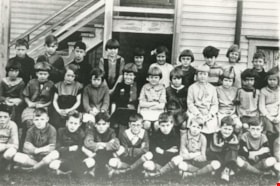
Inman Avenue school children
https://search.heritageburnaby.ca/link/archivedescription36727
- Repository
- City of Burnaby Archives
- Date
- [192-] (date of original), copied 1992
- Collection/Fonds
- Burnaby Historical Society fonds
- Description Level
- Item
- Physical Description
- 1 photograph : b&w ; 15 x 10 cm print
- Scope and Content
- Photograph of a group of school children, likely from Inman Avenue School.
- Repository
- City of Burnaby Archives
- Date
- [192-] (date of original), copied 1992
- Collection/Fonds
- Burnaby Historical Society fonds
- Subseries
- Burnaby Centennial Anthology subseries
- Physical Description
- 1 photograph : b&w ; 15 x 10 cm print
- Description Level
- Item
- Record No.
- 315-082
- Access Restriction
- No restrictions
- Reproduction Restriction
- No known restrictions
- Accession Number
- BHS1994-04
- Scope and Content
- Photograph of a group of school children, likely from Inman Avenue School.
- Names
- Inman Avenue School
- Media Type
- Photograph
- Notes
- Title based on contents of photograph
- Geographic Access
- Brandon Street
- Street Address
- 3963 Brandon Street
- Historic Neighbourhood
- Central Park (Historic Neighbourhood)
- Planning Study Area
- Garden Village Area
Images
![Inman Avenue school children, [192-] (date of original), copied 1992 thumbnail](/media/hpo/_Data/_Archives_Images/_Unrestricted/315/315-082.jpg)
![Inman Avenue School children, [192-] (date of original), copied 1992 thumbnail](/media/hpo/_Data/_Archives_Images/_Unrestricted/315/315-083.jpg?width=280)
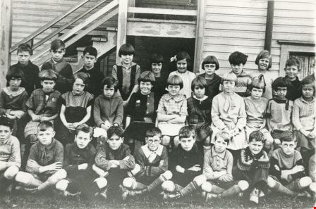
Inman Avenue School children
https://search.heritageburnaby.ca/link/archivedescription36728
- Repository
- City of Burnaby Archives
- Date
- [192-] (date of original), copied 1992
- Collection/Fonds
- Burnaby Historical Society fonds
- Description Level
- Item
- Physical Description
- 1 photograph : b&w ; 10.1 x 14.9 cm print
- Scope and Content
- Photograph of a group of school children and a teacher, likely from Inman Avenue School.
- Repository
- City of Burnaby Archives
- Date
- [192-] (date of original), copied 1992
- Collection/Fonds
- Burnaby Historical Society fonds
- Subseries
- Burnaby Centennial Anthology subseries
- Physical Description
- 1 photograph : b&w ; 10.1 x 14.9 cm print
- Description Level
- Item
- Record No.
- 315-083
- Access Restriction
- No restrictions
- Reproduction Restriction
- No known restrictions
- Accession Number
- BHS1994-04
- Scope and Content
- Photograph of a group of school children and a teacher, likely from Inman Avenue School.
- Subjects
- Occupations - Teachers
- Names
- Inman Avenue School
- Media Type
- Photograph
- Notes
- Title based on contents of photograph
- Geographic Access
- Brandon Street
- Street Address
- 3963 Brandon Street
- Historic Neighbourhood
- Central Park (Historic Neighbourhood)
- Planning Study Area
- Garden Village Area
Images
![Inman Avenue School children, [192-] (date of original), copied 1992 thumbnail](/media/hpo/_Data/_Archives_Images/_Unrestricted/315/315-083.jpg)
![Inman Avenue school children, [192-] (date of original), copied 1992 thumbnail](/media/hpo/_Data/_Archives_Images/_Unrestricted/315/315-084.jpg?width=280)
Inman Avenue school children
https://search.heritageburnaby.ca/link/archivedescription36729
- Repository
- City of Burnaby Archives
- Date
- [192-] (date of original), copied 1992
- Collection/Fonds
- Burnaby Historical Society fonds
- Description Level
- Item
- Physical Description
- 1 photograph : b&w ; 8.2 x 11.1 cm print
- Scope and Content
- Photograph of a group of school children, likely from Inman Avenue School.
- Repository
- City of Burnaby Archives
- Date
- [192-] (date of original), copied 1992
- Collection/Fonds
- Burnaby Historical Society fonds
- Subseries
- Burnaby Centennial Anthology subseries
- Physical Description
- 1 photograph : b&w ; 8.2 x 11.1 cm print
- Description Level
- Item
- Record No.
- 315-084
- Access Restriction
- No restrictions
- Reproduction Restriction
- No known restrictions
- Accession Number
- BHS1994-04
- Scope and Content
- Photograph of a group of school children, likely from Inman Avenue School.
- Names
- Inman Avenue School
- Media Type
- Photograph
- Notes
- Title based on contents of photograph
- Geographic Access
- Brandon Street
- Street Address
- 3963 Brandon Street
- Historic Neighbourhood
- Central Park (Historic Neighbourhood)
- Planning Study Area
- Garden Village Area
Images
![Inman Avenue school children, [192-] (date of original), copied 1992 thumbnail](/media/hpo/_Data/_Archives_Images/_Unrestricted/315/315-084.jpg)
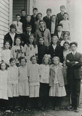
Inman Avenue School class
https://search.heritageburnaby.ca/link/archivedescription35232
- Repository
- City of Burnaby Archives
- Date
- 1928 (date of original), copied 1986
- Collection/Fonds
- Burnaby Historical Society fonds
- Description Level
- Item
- Physical Description
- 1 photograph : b&w ; 12.7 x 17.8 cm print
- Scope and Content
- Photograph of Inman Avenue School students. Grace Farrington is in the 2nd row, 5th from left, next to the girl in the checked dress.
- Repository
- City of Burnaby Archives
- Date
- 1928 (date of original), copied 1986
- Collection/Fonds
- Burnaby Historical Society fonds
- Subseries
- Pioneer Tales subseries
- Physical Description
- 1 photograph : b&w ; 12.7 x 17.8 cm print
- Description Level
- Item
- Record No.
- 204-089
- Access Restriction
- No restrictions
- Reproduction Restriction
- No known restrictions
- Accession Number
- BHS1988-03
- Scope and Content
- Photograph of Inman Avenue School students. Grace Farrington is in the 2nd row, 5th from left, next to the girl in the checked dress.
- Media Type
- Photograph
- Notes
- Title based on contents of photograph
- Geographic Access
- Brandon Street
- Street Address
- 3963 Brandon Street
- Historic Neighbourhood
- Central Park (Historic Neighbourhood)
- Planning Study Area
- Garden Village Area
Images
Inman, Burnaby, B.C.
https://search.heritageburnaby.ca/link/archivedescription66388
- Repository
- City of Burnaby Archives
- Date
- 1954
- Collection/Fonds
- Grieve family fonds
- Description Level
- Item
- Physical Description
- 1 photograph : b&w ; 11.5 x 16.5 cm
- Scope and Content
- Photograph of the exterior of Inman Avenue School.
- Repository
- City of Burnaby Archives
- Date
- 1954
- Collection/Fonds
- Grieve family fonds
- Physical Description
- 1 photograph : b&w ; 11.5 x 16.5 cm
- Description Level
- Item
- Record No.
- 523-002
- Access Restriction
- No restrictions
- Reproduction Restriction
- No known restrictions
- Accession Number
- 2011-04
- Scope and Content
- Photograph of the exterior of Inman Avenue School.
- Subjects
- Buildings - Schools
- Names
- Inman Avenue School
- Media Type
- Photograph
- Notes
- Title based on contents of photograph
- Photographer's writing (engraved on negative) reads: "Layton / Inman. Burnaby, B.C. / 1954"
- Geographic Access
- Brandon Street
- Street Address
- 3963 Brandon Street
- Historic Neighbourhood
- Central Park (Historic Neighbourhood)
- Planning Study Area
- Garden Village Area
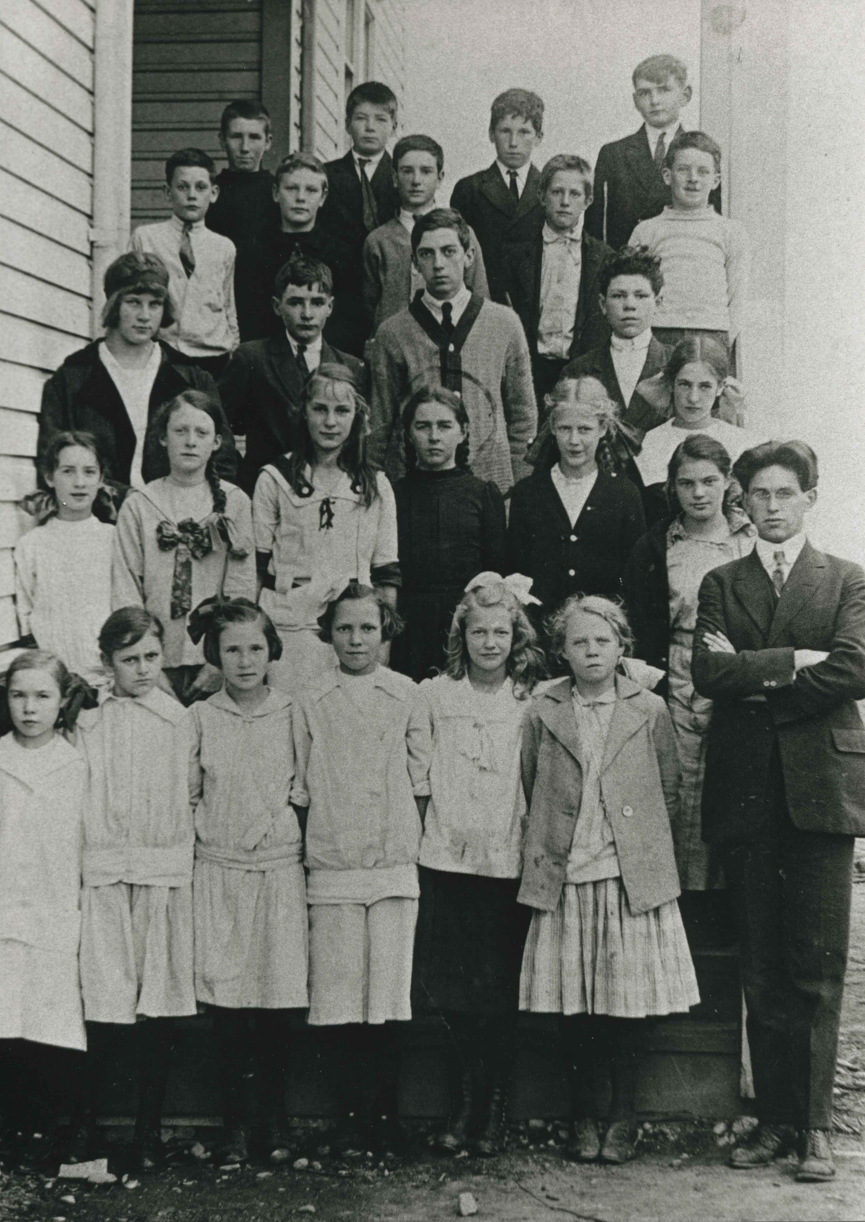
Inman School Class
https://search.heritageburnaby.ca/link/archivedescription35218
- Repository
- City of Burnaby Archives
- Date
- 1912 (date of original), copied 1986
- Collection/Fonds
- Burnaby Historical Society fonds
- Description Level
- Item
- Physical Description
- 1 photograph : b&w ; 12.7 x 17.8 cm print
- Scope and Content
- Photograph of Inman Avenue School class. Marjorie Cassidy is in the 2nd row, 4th from left. The teacher, to the right, is Mr. Lowther. The Cassidy children, from oldest, are Willie, Marjorie, Mary and Katie.
- Repository
- City of Burnaby Archives
- Date
- 1912 (date of original), copied 1986
- Collection/Fonds
- Burnaby Historical Society fonds
- Subseries
- Pioneer Tales subseries
- Physical Description
- 1 photograph : b&w ; 12.7 x 17.8 cm print
- Description Level
- Item
- Record No.
- 204-075
- Access Restriction
- No restrictions
- Reproduction Restriction
- No known restrictions
- Accession Number
- BHS1988-03
- Scope and Content
- Photograph of Inman Avenue School class. Marjorie Cassidy is in the 2nd row, 4th from left. The teacher, to the right, is Mr. Lowther. The Cassidy children, from oldest, are Willie, Marjorie, Mary and Katie.
- Subjects
- Occupations - Teachers
- Media Type
- Photograph
- Notes
- Title based on contents of photograph
- Geographic Access
- Brandon Street
- Street Address
- 3963 Brandon Street
- Historic Neighbourhood
- Central Park (Historic Neighbourhood)
- Planning Study Area
- Garden Village Area
Images

Kingsway
https://search.heritageburnaby.ca/link/archivedescription34510
- Repository
- City of Burnaby Archives
- Date
- 1920
- Collection/Fonds
- Burnaby Historical Society fonds
- Description Level
- Item
- Physical Description
- 1 photograph : sepia ; 12.6 x 17.7 cm
- Scope and Content
- Photograph of Kingsway looking east at Boundary Road. A sign on the right reads, "Burnaby / Vehicles must slow down at all schools and intersections marked thus: X." A sign on a building at the left reads, "Arctic Ice Cream." Central Park is on the right.
- Repository
- City of Burnaby Archives
- Date
- 1920
- Collection/Fonds
- Burnaby Historical Society fonds
- Subseries
- Photographs subseries
- Physical Description
- 1 photograph : sepia ; 12.6 x 17.7 cm
- Description Level
- Item
- Record No.
- 031-001
- Access Restriction
- No restrictions
- Reproduction Restriction
- No known restrictions
- Accession Number
- BHS2007-04
- Scope and Content
- Photograph of Kingsway looking east at Boundary Road. A sign on the right reads, "Burnaby / Vehicles must slow down at all schools and intersections marked thus: X." A sign on a building at the left reads, "Arctic Ice Cream." Central Park is on the right.
- Media Type
- Photograph
- Notes
- Title based on contents of photograph
- Geographic Access
- Kingsway
- Central Park
- Boundary Road
- Historic Neighbourhood
- Central Park (Historic Neighbourhood)
- Planning Study Area
- Garden Village Area
- Maywood Area
Images


Kingsway
https://search.heritageburnaby.ca/link/archivedescription34511
- Repository
- City of Burnaby Archives
- Date
- 1920
- Collection/Fonds
- Burnaby Historical Society fonds
- Description Level
- Item
- Physical Description
- 1 photograph : sepia ; 12.6 x 17.6 cm
- Scope and Content
- Photograph of Kingsway looking east at Boundary Road. A sign on the right reads, "Burnaby / Vehicles must slow down at all schools and intersections marked thus: X." A sign on a building at the left reads, "Arctic Ice Cream." Central Park is on the right.
- Repository
- City of Burnaby Archives
- Date
- 1920
- Collection/Fonds
- Burnaby Historical Society fonds
- Subseries
- Photographs subseries
- Physical Description
- 1 photograph : sepia ; 12.6 x 17.6 cm
- Description Level
- Item
- Record No.
- 031-002
- Access Restriction
- No restrictions
- Reproduction Restriction
- No known restrictions
- Accession Number
- BHS2007-04
- Scope and Content
- Photograph of Kingsway looking east at Boundary Road. A sign on the right reads, "Burnaby / Vehicles must slow down at all schools and intersections marked thus: X." A sign on a building at the left reads, "Arctic Ice Cream." Central Park is on the right.
- Subjects
- Geographic Features - Roads
- Advertising Medium - Signs and Signboards
- Transportation - Automobiles
- Media Type
- Photograph
- Notes
- Title based on contents of photograph
- Geographic Access
- Kingsway
- Central Park
- Boundary Road
- Historic Neighbourhood
- Central Park (Historic Neighbourhood)
- Planning Study Area
- Garden Village Area
- Maywood Area
Images


Municipal Road Crew
https://search.heritageburnaby.ca/link/archivedescription79439
- Repository
- City of Burnaby Archives
- Date
- September 23, 1976
- Collection/Fonds
- Burnaby Public Library Contemporary Visual Archive Project
- Description Level
- Item
- Physical Description
- 1 photograph : b&w ; 11 x 16 cm mounted on cardboard
- Scope and Content
- Photograph shows a municipal road crew resurfacing Boundary Road near Imperial Street.
- Repository
- City of Burnaby Archives
- Date
- September 23, 1976
- Collection/Fonds
- Burnaby Public Library Contemporary Visual Archive Project
- Physical Description
- 1 photograph : b&w ; 11 x 16 cm mounted on cardboard
- Description Level
- Item
- Record No.
- 556-291
- Access Restriction
- No restrictions
- Reproduction Restriction
- Reproduce for fair dealing purposes only
- Accession Number
- 2013-13
- Scope and Content
- Photograph shows a municipal road crew resurfacing Boundary Road near Imperial Street.
- Media Type
- Photograph
- Photographer
- Ross, Martha
- Notes
- Scope note taken directly from BPL photograph description.
- 1 b&w copy negative : 10 x 12.5 cm accompanying
- Geographic Access
- Boundary Road
- Imperial Street
- Historic Neighbourhood
- Central Park (Historic Neighbourhood)
- Planning Study Area
- Suncrest Area
Images
