![10th Avenue connector construction, [2002] thumbnail](/media/hpo/_Data/_Archives_Images/_Unrestricted/535/535-1984.jpg?width=280)
10th Avenue connector construction
https://search.heritageburnaby.ca/link/archivedescription96301
- Repository
- City of Burnaby Archives
- Date
- [2002]
- Collection/Fonds
- Burnaby NewsLeader photograph collection
- Description Level
- Item
- Physical Description
- 1 photograph (tiff) : col.
- Scope and Content
- Photograph of the view of the new 10th Avenue connector from Gord Thorneycroft's garage. Thorneycroft holds a mug and is silhouetted by the light coming from outside, where the Bombardier SkyTrain plant is visible in the distance.
- Repository
- City of Burnaby Archives
- Date
- [2002]
- Collection/Fonds
- Burnaby NewsLeader photograph collection
- Physical Description
- 1 photograph (tiff) : col.
- Description Level
- Item
- Record No.
- 535-1984
- Access Restriction
- No restrictions
- Reproduction Restriction
- No restrictions
- Accession Number
- 2018-12
- Scope and Content
- Photograph of the view of the new 10th Avenue connector from Gord Thorneycroft's garage. Thorneycroft holds a mug and is silhouetted by the light coming from outside, where the Bombardier SkyTrain plant is visible in the distance.
- Media Type
- Photograph
- Photographer
- Bartel, Mario
- Notes
- Title based on caption
- Collected by editorial for use in a February 2002 issue of the Burnaby NewsLeader
- Caption from metadata: "Gord Thorneycroft says he used to be able to enjoy his morning coffee looking out onto a quiet, tree-lined lane while working in his garage behind his home on 9th Ave. But workers building the new 10th Ave. connector tore out the trees last September, the City of Burnaby isn't making any promises to erect noise barriers, and his lane has become a thoroughfare to the Bombardier Skytrain plant."
- Geographic Access
- 10th Avenue
- Historic Neighbourhood
- Edmonds (Historic Neighbourhood)
- Planning Study Area
- Stride Avenue Area
Images
![10th Avenue connector construction, [2002] thumbnail](/media/hpo/_Data/_Archives_Images/_Unrestricted/535/535-1984.jpg)

Construction on Acorn Avenue
https://search.heritageburnaby.ca/link/archivedescription79040
- Repository
- City of Burnaby Archives
- Date
- October 20, 1976
- Collection/Fonds
- Burnaby Public Library Contemporary Visual Archive Project
- Description Level
- Item
- Physical Description
- 1 photograph : b&w ; 11 x 16 cm mounted on cardboard
- Scope and Content
- Photograph shows a view from Hall Towers of houses and a high-rise under construction on Acorn Avenue.
- Repository
- City of Burnaby Archives
- Date
- October 20, 1976
- Collection/Fonds
- Burnaby Public Library Contemporary Visual Archive Project
- Physical Description
- 1 photograph : b&w ; 11 x 16 cm mounted on cardboard
- Description Level
- Item
- Record No.
- 556-108
- Access Restriction
- No restrictions
- Reproduction Restriction
- Reproduce for fair dealing purposes only
- Accession Number
- 2013-13
- Scope and Content
- Photograph shows a view from Hall Towers of houses and a high-rise under construction on Acorn Avenue.
- Media Type
- Photograph
- Photographer
- Ross, Martha
- Notes
- Scope note taken directly from BPL photograph description.
- 1 b&w copy negative : 10 x 12.5 cm accompanying
- Geographic Access
- Acorn Avenue
- Historic Neighbourhood
- Edmonds (Historic Neighbourhood)
- Planning Study Area
- Stride Avenue Area
Images

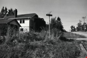
Corner of Salisbury Avenue and 21st Avenue
https://search.heritageburnaby.ca/link/archivedescription78866
- Repository
- City of Burnaby Archives
- Date
- September 23, 1976
- Collection/Fonds
- Burnaby Public Library Contemporary Visual Archive Project
- Description Level
- Item
- Physical Description
- 1 photograph : b&w ; 11 x 16 cm mounted on cardboard
- Scope and Content
- Photograph shows an abandoned house and garage at the corner of Salisbury Avenue and 21st Avenue. The house and garage have been completely demolished since the picture was taken.
- Repository
- City of Burnaby Archives
- Date
- September 23, 1976
- Collection/Fonds
- Burnaby Public Library Contemporary Visual Archive Project
- Physical Description
- 1 photograph : b&w ; 11 x 16 cm mounted on cardboard
- Description Level
- Item
- Record No.
- 556-010
- Access Restriction
- No restrictions
- Reproduction Restriction
- Reproduce for fair dealing purposes only
- Accession Number
- 2013-13
- Scope and Content
- Photograph shows an abandoned house and garage at the corner of Salisbury Avenue and 21st Avenue. The house and garage have been completely demolished since the picture was taken.
- Media Type
- Photograph
- Photographer
- Ross, Martha
- Notes
- Scope note taken directly from BPL photograph description.
- 1 b&w copy negative : 10 x 12.5 cm accompanying
- Geographic Access
- Salisbury Avenue
- 21st Avenue
- Historic Neighbourhood
- Edmonds (Historic Neighbourhood)
- Planning Study Area
- Stride Avenue Area
Images
![Fire fighters with burned car, [1999] thumbnail](/media/hpo/_Data/_Archives_Images/_Unrestricted/535/535-3154.jpg?width=280)
Fire fighters with burned car
https://search.heritageburnaby.ca/link/archivedescription98074
- Repository
- City of Burnaby Archives
- Date
- [1999]
- Collection/Fonds
- Burnaby NewsLeader photograph collection
- Description Level
- Item
- Physical Description
- 1 photograph (tiff) : col.
- Scope and Content
- Photograph of Burnaby fire fighters with a burned-up car that they pushed from a garage of a home at the 7300 block of 10th Avenue.
- Repository
- City of Burnaby Archives
- Date
- [1999]
- Collection/Fonds
- Burnaby NewsLeader photograph collection
- Physical Description
- 1 photograph (tiff) : col.
- Description Level
- Item
- Record No.
- 535-3154
- Access Restriction
- No restrictions
- Reproduction Restriction
- No restrictions
- Accession Number
- 2018-12
- Scope and Content
- Photograph of Burnaby fire fighters with a burned-up car that they pushed from a garage of a home at the 7300 block of 10th Avenue.
- Names
- Burnaby Fire Department
- Media Type
- Photograph
- Photographer
- Bartel, Mario
- Notes
- Title based on caption
- Collected by editorial for use in an April 1999 issue of the Burnaby NewsLeader
- Caption from metadata: "Burnaby firefighters averted a bigger catastrophe when they managed to push a burning Valiant from a garage in the 7300 block of 10th Ave. Damage was restricted to the car, and some smoke in the garage."
- Geographic Access
- 10th Avenue
- Historic Neighbourhood
- Edmonds (Historic Neighbourhood)
- Planning Study Area
- Stride Avenue Area
Images
![Fire fighters with burned car, [1999] thumbnail](/media/hpo/_Data/_Archives_Images/_Unrestricted/535/535-3154.jpg)

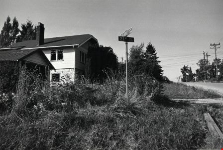
House at 1279 10th Avenue
https://search.heritageburnaby.ca/link/archivedescription78979
- Repository
- City of Burnaby Archives
- Date
- September 16, 1976
- Collection/Fonds
- Burnaby Public Library Contemporary Visual Archive Project
- Description Level
- Item
- Physical Description
- 1 photograph : b&w ; 11 x 16 cm mounted on cardboard
- Scope and Content
- Photograph shows a house at 1279 10th Avenue, near 15th Street. This house was built in 1910 and was one of the oldest in the area at the time the photograph was taken. It was originally part of a fruit orchard of several acres.
- Repository
- City of Burnaby Archives
- Date
- September 16, 1976
- Collection/Fonds
- Burnaby Public Library Contemporary Visual Archive Project
- Physical Description
- 1 photograph : b&w ; 11 x 16 cm mounted on cardboard
- Description Level
- Item
- Record No.
- 556-064
- Access Restriction
- No restrictions
- Reproduction Restriction
- Reproduce for fair dealing purposes only
- Accession Number
- 2013-13
- Scope and Content
- Photograph shows a house at 1279 10th Avenue, near 15th Street. This house was built in 1910 and was one of the oldest in the area at the time the photograph was taken. It was originally part of a fruit orchard of several acres.
- Media Type
- Photograph
- Photographer
- Ross, Martha
- Notes
- Scope note taken directly from BPL photograph description.
- 1 b&w copy negative : 10 x 12.5 cm accompanying
- Geographic Access
- 10th Avenue
- Street Address
- 1279 10th Avenue
- Historic Neighbourhood
- Edmonds (Historic Neighbourhood)
- Planning Study Area
- Stride Avenue Area
Images
