Narrow Results By

Horne-Payne Receiving Station
https://search.heritageburnaby.ca/link/landmark594
- Repository
- Burnaby Heritage Planning
- Description
- Industrial building.
- Associated Dates
- 1913
- Street View URL
- Google Maps Street View
- Repository
- Burnaby Heritage Planning
- Geographic Access
- 2nd Avenue
- Associated Dates
- 1913
- Description
- Industrial building.
- Heritage Value
- Constructed as an electrical grid substation by the B.C. Electric Railway Company, the Horne-Payne substation was part of the expansion of this utility company to central Burnaby that occurred as a result of the opening of the Burnaby Lake Interurban line in 1911. The Receiving Station is intended to rearrange the company’s system of distributing power over the whole of the Burrard Peninsula. Power will come to the transformers there and be converted and distributed to the various substations in Vancouver, New Westminster and the suburbs...Work has already been started at the foundation for the new plant. (Vancouver Daily Province, April 29, 1913) When constructed the substation was situated within a forest clearing in a largely undeveloped section of northwest Burnaby. The area now surrounding the substation is heavily developed for semi-industrial purposes. This steel-frame and poured concrete structure was designed to be utilitarian, but with decorative detailing. The south-facing front of the structure features massed corners detailed with decorative relief panels at the roofline. Additionally, this well-balanced building displayed symmetrical fenestration with blind, and tall multi-paned steel-sash windows, some crowned with keystones. A tower added to the east side of the building’s front is the most substantial change made to the appearance of the Horne-Payne substation. This industrial structure was designed by prominent British Columbian architect, Robert Lyon (1879-1963). Born in Edinburgh, Lyon apprenticed and worked as an architect in Scotland until 1908 before moving to New York in 1909. In 1911, he began his career in Vancouver as an “architectural engineer,” with the B.C. Electric Company that lasted until 1918. After a short tenure in the lumber industry, Lyon returned to architecture, this time with his own firm in Penticton. Active in municipal politics, he was instrumental in the incorporation of Penticton as a city, and became its first mayor from 1948-1949. Lyon retired from architecture in 1958 and died in 1963. Lyon also designed the Central Park Gate in Burnaby.
- Locality
- Vancouver Heights
- Historic Neighbourhood
- Vancouver Heights (Historic Neighbourhood)
- Planning Study Area
- West Central Valley Area
- Architect
- Robert Lyon
- Area
- 47400.00
- Contributing Resource
- Building
- Ownership
- Private
- Street Address
- 3700 2nd Street
- Street View URL
- Google Maps Street View
Images


Charles R. Shaw House
https://search.heritageburnaby.ca/link/landmark525
- Repository
- Burnaby Heritage Planning
- Description
- The Charles R. Shaw House is a one and one-half storey plus basement wood-frame late Victorian era residence, located on the grounds of the Normanna Rest Home development in East Burnaby, near its original location on this site. Originally a modest vernacular Victorian structure, it has been enlarg…
- Associated Dates
- 1891
- Formal Recognition
- Heritage Designation, Community Heritage Register
- Other Names
- Charles R. & Mary Shaw House
- Street View URL
- Google Maps Street View
- Repository
- Burnaby Heritage Planning
- Other Names
- Charles R. & Mary Shaw House
- Geographic Access
- 12th Avenue
- 4th Street
- 13th Avenue
- Associated Dates
- 1891
- Formal Recognition
- Heritage Designation, Community Heritage Register
- Enactment Type
- Bylaw No. 10739
- Enactment Date
- 06/04/1998
- Description
- The Charles R. Shaw House is a one and one-half storey plus basement wood-frame late Victorian era residence, located on the grounds of the Normanna Rest Home development in East Burnaby, near its original location on this site. Originally a modest vernacular Victorian structure, it has been enlarged and embellished through later additions.
- Heritage Value
- The Shaw House is one of the oldest surviving houses in Burnaby, and is valued as a representation of a typical vernacular pioneer house in Burnaby, and a rare survivor from the late Victorian era. The original portion of the house displays a simplicity of form and detail consistent with early local construction, while the later additions display a more sophisticated approach. Originally built in 1891, this house is valued for its association with first owner, Charles R. Shaw (1834-1916) and Mary D. Shaw (1848-1897), one of Burnaby’s earliest settlers. Born in England, Shaw immigrated to Toronto in 1869, and relocated to New Westminster in 1889, where he worked as an employee of the Mechanic's Mill Company, an early woodworking plant. After moving to Burnaby, he was unanimously elected by acclamation as first reeve (mayor) of the new municipality in 1892. In 1894, Shaw sold his house and farm and moved his family to Kamloops due to his wife Mary's failing health. After Mary died in 1897, the Shaw family returned to Toronto. The Shaw House is additionally valued for its association with a later owner, James Brookes (1884-1953), founder of James Brookes Woodworking Ltd., a mill that was a major employer in East Burnaby. Brookes bought and renovated the house in 1917. In 1927, he built a much larger house on the property (now demolished), and the original house was moved to the corner of the property to serve as a gardener's cottage for Brookes' estate. The additions made to the house at this time employed sash and milled products produced by the Brookes plant. Although altered, this Victorian era residence remains largely intact, with Brookes’s later additions.
- Defining Elements
- Key elements that define the heritage character of the Shaw House include its: - modest vernacular residential form, scale and massing, as exemplified by its one and one-half storey plus basement height, front gabled roof, shed roofed verandah and asymmetrical plan - asymmetrical front entrance - cladding: horizontal wooden drop siding on the original portion of the house; cedar shingles on additions; decorative octagonal cedar shingles in the front gable; original decorated bargeboards at front, with cut-out details - later renovations to the front verandah and side addition which resulted in a partially glazed porch entrance and addition with large window assemblies - square verandah columns - irregular fenestration: double-hung wooden-sash windows in a variety of configurations such as 6-over-1 and 4-over-1 windows in the original portion of the house, 12-over-1 windows, and one 24-over-1 window in the front addition - small window at front entry - fifteen-pane French front entry door - internal red brick chimney with corbelled cap
- Historic Neighbourhood
- East Burnaby (Historic Neighbourhood)
- Planning Study Area
- Edmonds Area
- Function
- Primary Historic--Single Dwelling
- Primary Current--Single Dwelling
- Community
- Burnaby
- Cadastral Identifier
- 003-253-848
- Boundaries
- The Shaw House is comprised of a single residential lot located at 7725 Fourth Street (legal address), Burnaby
- Area
- 9199.27
- Contributing Resource
- Building
- Ownership
- Private
- Names
- Shaw, Charles R
- Street Address
- 7725 4th Street
- Street View URL
- Google Maps Street View
Images


Central Park testing station
https://search.heritageburnaby.ca/link/archivedescription95101
- Repository
- City of Burnaby Archives
- Date
- May 9, 2020
- Collection/Fonds
- Burnaby Photographic Society fonds
- Description Level
- Item
- Physical Description
- 1 photograph (tiff)
- Scope and Content
- Photograph of the COVID-19 testing station located in the Central Park parking lot off Boundary Road. A sign in the foreground reads "Covid-19 Care Site by Referral Only / Walk in Access". In the background, the white tents of the testing station are visible.
- Repository
- City of Burnaby Archives
- Date
- May 9, 2020
- Collection/Fonds
- Burnaby Photographic Society fonds
- Physical Description
- 1 photograph (tiff)
- Description Level
- Item
- Record No.
- 623-019
- Access Restriction
- No restrictions
- Reproduction Restriction
- No restrictions
- Accession Number
- 2020-10
- Scope and Content
- Photograph of the COVID-19 testing station located in the Central Park parking lot off Boundary Road. A sign in the foreground reads "Covid-19 Care Site by Referral Only / Walk in Access". In the background, the white tents of the testing station are visible.
- Subjects
- Geographic Features - Parks
- Geographic Features - Automobile Parking Lots
- Advertising Medium - Signs and Signboards
- Structures - Tents
- Media Type
- Photograph
- Photographer
- Damer, Eric
- Notes
- Transcribed title
- Geographic Access
- Boundary Road
- Central Park
- Historic Neighbourhood
- Central Park (Historic Neighbourhood)
- Planning Study Area
- Maywood Area
Images

brochure
https://search.heritageburnaby.ca/link/museumartifact91856
- Repository
- Burnaby Village Museum
- Accession Code
- BV023.23.2
- Description
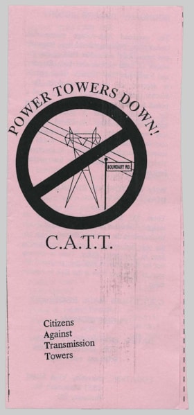
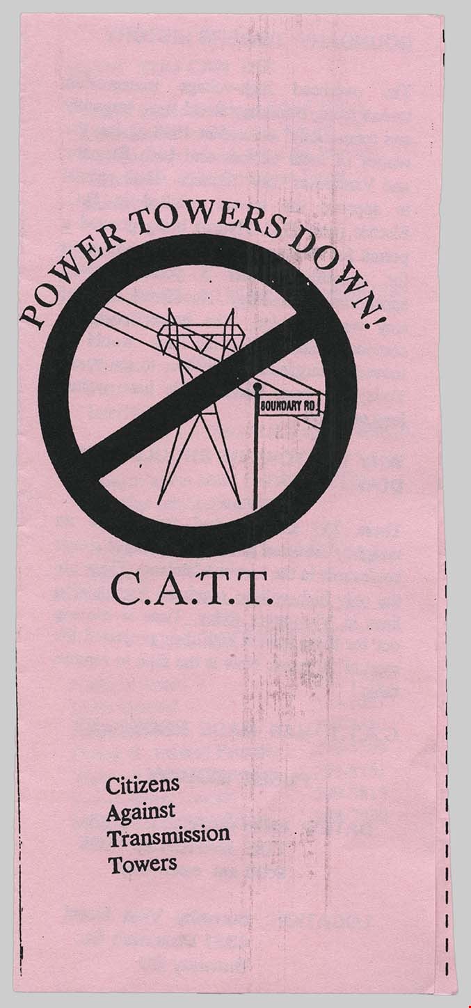
- Power Towers Down! - Brochure -- [1995]. Bifold brochure printed on pink paper from the Citizens Against Transmission Towers (C.A.T.T.) organization providing information on the history of the transmission towers on Boundary Road and why they should come down. The brochure has information about a public inquiry that was held on March 27 and 28 1995 at the Burnaby Villa Hotel.
- Object History
- The Citizens Against Transmission Towers (CATT) was a grassroots organization that was formed in 1994 by resident on either side of Boundary Road in Vancouver and Burnaby. The power lines were put up all along half of Boundary Road in 1948 as a result of an urgent need by Vancouver and Burnaby city councils. At the time, they were not built to the current (1990s) safety standards, as they were intended to be temporary. The group was concerned about the safety of the old structures as well as about the health concerns sometimes associated to power lines.
- Category
- 08. Communication Artifacts
- Classification
- Advertising Media
- Object Term
- Brochure
- Measurements
- Height: 22 cm
- Width: 10 cm
- Geographic Access
- Boundary Road
Images


Dominion Bridge Company Limited - Burnaby Plant
https://search.heritageburnaby.ca/link/museumdescription17538
- Repository
- Burnaby Village Museum
- Date
- 29 Aug. 1957
- Collection/Fonds
- Burnaby Village Museum Map collection
- Description Level
- Item
- Physical Description
- 1 plan : col. lithographic print ; 50.5 x 84 cm
- Scope and Content
- Item consists of a fire insurance plan of the Dominion Bridge Company Burnaby Plant located on the east side of Boundary Road near Lougheed Highway. The plan is in two sheets mounted on a backing board. The buildings are located and colour coded. The plan includes profiles of the buildings. Title o…
- Repository
- Burnaby Village Museum
- Collection/Fonds
- Burnaby Village Museum Map collection
- Description Level
- Item
- Physical Description
- 1 plan : col. lithographic print ; 50.5 x 84 cm
- Material Details
- Scale [1:960]
- Scope and Content
- Item consists of a fire insurance plan of the Dominion Bridge Company Burnaby Plant located on the east side of Boundary Road near Lougheed Highway. The plan is in two sheets mounted on a backing board. The buildings are located and colour coded. The plan includes profiles of the buildings. Title on plan reads "DOMINION BRIDGE COMPANY, LIMITED / "BURNABY PLANT" / Burnaby, B.C.". The site plan was surveyed by C. L. Schwaab Jr.
- History
- Dominion Bridge Company was a major enterprise in Burnaby operating from the 1930 until the mid 1970s. Dominion Bridge constructed steel structures ranging from portions of the Golden Gate and Lions Gate Bridges to holding tanks for pulp mills. Beginning in the mid-1970s, unused areas of the site were used for filming on a temporary basis and in 1987 the site was established as a dedicated studio production facility named Bridge Studios.
- Creator
- Schwabb, C.L. Jr.
- Subjects
- Buildings - Industrial - Factories
- Names
- Dominion Bridge Company
- Responsibility
- Associated Factory Mutual Fire Insurance Cos
- Geographic Access
- Boundary Road
- Street Address
- 2400 Boundary Road
- Accession Code
- BV015.10.1
- Access Restriction
- Restricted access
- Reproduction Restriction
- May be restricted by third party rights
- Date
- 29 Aug. 1957
- Media Type
- Cartographic Material
- Historic Neighbourhood
- Broadview (Historic Neighbourhood)
- Planning Study Area
- West Central Valley Area
- Scan Resolution
- 400
- Scan Date
- 2021-11-28
- Notes
- Title based on contents of plan
- Scale on plan reads "1 inch = 80 ft / By V. Pitkin"
- Identfication information in bottom right corner of plan reads: "FACTORY MUTUAL ENGINEERING DIVISION / Associated Factory Mutual Fire Insurance Cos. / Norwood, Mass. / SERIAl 47330 / Replacing 35238 / INDEX 3994"