Narrow Results By
Subject
- Advertising Medium - Signs and Signboards 1
- Buildings 1
- Buildings - Commercial 3
- Buildings - Commercial - General Stores 1
- Buildings - Commercial - Grocery Stores 3
- Buildings - Industrial 1
- Buildings - Industrial - Factories 1
- Buildings - Recreational - Community Halls 1
- Buildings - Religious - Churches 1
- Buildings - Residential - Houses 6
- Buildings - Schools 11
- Construction 1

Second Street School
https://search.heritageburnaby.ca/link/landmark638
- Repository
- Burnaby Heritage Planning
- Description
- School building.
- Associated Dates
- 1928
- Street View URL
- Google Maps Street View
- Repository
- Burnaby Heritage Planning
- Geographic Access
- 2nd Street
- Associated Dates
- 1928
- Description
- School building.
- Heritage Value
- The Second Street School was originally established at this location as a two-room schoolhouse in 1913 to relieve the overcrowding of Edmonds School during the pre-First World War building boom. The old school was converted into an auditorium when this handsome school building was constructed in 1928. The new school, built by local contractors Ward-Leverington Ltd., included four classrooms, a library, a room for the principal, and a room for the teachers. The original brick façade has been retained although it has been painted; other intact original features include the bellcast octagonal roof ventilator and the protruding front entrance. The Burnaby School Board architect at this time was the talented firm of McCarter & Nairne, who also designed the Douglas Road School. John Y. McCarter (1886-1981) and George Nairne (1884-1953) formed their partnership in 1921 after serving overseas during the First World War. The partners began designing houses and small apartment buildings, and larger commissions soon followed, including Vancouver’s first skyscraper, the Marine Building (1928-30).
- Locality
- East Burnaby
- Historic Neighbourhood
- East Burnaby (Historic Neighbourhood)
- Planning Study Area
- Second Street Area
- Architect
- McCarter & Nairne
- Area
- 15777.66
- Contributing Resource
- Building
- Street Address
- 7502 2nd Street
- Street View URL
- Google Maps Street View
Images


Charles R. Shaw House
https://search.heritageburnaby.ca/link/landmark525
- Repository
- Burnaby Heritage Planning
- Description
- The Charles R. Shaw House is a one and one-half storey plus basement wood-frame late Victorian era residence, located on the grounds of the Normanna Rest Home development in East Burnaby, near its original location on this site. Originally a modest vernacular Victorian structure, it has been enlarg…
- Associated Dates
- 1891
- Formal Recognition
- Heritage Designation, Community Heritage Register
- Other Names
- Charles R. & Mary Shaw House
- Street View URL
- Google Maps Street View
- Repository
- Burnaby Heritage Planning
- Other Names
- Charles R. & Mary Shaw House
- Geographic Access
- 12th Avenue
- 4th Street
- 13th Avenue
- Associated Dates
- 1891
- Formal Recognition
- Heritage Designation, Community Heritage Register
- Enactment Type
- Bylaw No. 10739
- Enactment Date
- 06/04/1998
- Description
- The Charles R. Shaw House is a one and one-half storey plus basement wood-frame late Victorian era residence, located on the grounds of the Normanna Rest Home development in East Burnaby, near its original location on this site. Originally a modest vernacular Victorian structure, it has been enlarged and embellished through later additions.
- Heritage Value
- The Shaw House is one of the oldest surviving houses in Burnaby, and is valued as a representation of a typical vernacular pioneer house in Burnaby, and a rare survivor from the late Victorian era. The original portion of the house displays a simplicity of form and detail consistent with early local construction, while the later additions display a more sophisticated approach. Originally built in 1891, this house is valued for its association with first owner, Charles R. Shaw (1834-1916) and Mary D. Shaw (1848-1897), one of Burnaby’s earliest settlers. Born in England, Shaw immigrated to Toronto in 1869, and relocated to New Westminster in 1889, where he worked as an employee of the Mechanic's Mill Company, an early woodworking plant. After moving to Burnaby, he was unanimously elected by acclamation as first reeve (mayor) of the new municipality in 1892. In 1894, Shaw sold his house and farm and moved his family to Kamloops due to his wife Mary's failing health. After Mary died in 1897, the Shaw family returned to Toronto. The Shaw House is additionally valued for its association with a later owner, James Brookes (1884-1953), founder of James Brookes Woodworking Ltd., a mill that was a major employer in East Burnaby. Brookes bought and renovated the house in 1917. In 1927, he built a much larger house on the property (now demolished), and the original house was moved to the corner of the property to serve as a gardener's cottage for Brookes' estate. The additions made to the house at this time employed sash and milled products produced by the Brookes plant. Although altered, this Victorian era residence remains largely intact, with Brookes’s later additions.
- Defining Elements
- Key elements that define the heritage character of the Shaw House include its: - modest vernacular residential form, scale and massing, as exemplified by its one and one-half storey plus basement height, front gabled roof, shed roofed verandah and asymmetrical plan - asymmetrical front entrance - cladding: horizontal wooden drop siding on the original portion of the house; cedar shingles on additions; decorative octagonal cedar shingles in the front gable; original decorated bargeboards at front, with cut-out details - later renovations to the front verandah and side addition which resulted in a partially glazed porch entrance and addition with large window assemblies - square verandah columns - irregular fenestration: double-hung wooden-sash windows in a variety of configurations such as 6-over-1 and 4-over-1 windows in the original portion of the house, 12-over-1 windows, and one 24-over-1 window in the front addition - small window at front entry - fifteen-pane French front entry door - internal red brick chimney with corbelled cap
- Historic Neighbourhood
- East Burnaby (Historic Neighbourhood)
- Planning Study Area
- Edmonds Area
- Function
- Primary Historic--Single Dwelling
- Primary Current--Single Dwelling
- Community
- Burnaby
- Cadastral Identifier
- 003-253-848
- Boundaries
- The Shaw House is comprised of a single residential lot located at 7725 Fourth Street (legal address), Burnaby
- Area
- 9199.27
- Contributing Resource
- Building
- Ownership
- Private
- Names
- Shaw, Charles R
- Street Address
- 7725 4th Street
- Street View URL
- Google Maps Street View
Images


D.C. Patterson House
https://search.heritageburnaby.ca/link/landmark517
- Repository
- Burnaby Heritage Planning
- Description
- The D.C. Patterson House is a one and one-half storey plus basement wood-frame Edwardian era residence with a full-width front verandah and symmetrical saddlebag dormers. It is located adjacent to a ravine park and is part of the Winston Gate development.
- Associated Dates
- 1910
- Formal Recognition
- Heritage Designation, Community Heritage Register
- Other Names
- Dugald & Frances Patterson House
- Street View URL
- Google Maps Street View
- Repository
- Burnaby Heritage Planning
- Other Names
- Dugald & Frances Patterson House
- Geographic Access
- 12th Avenue
- Associated Dates
- 1910
- Formal Recognition
- Heritage Designation, Community Heritage Register
- Enactment Type
- Bylaw No. 10062
- Enactment Date
- 11/07/1994
- Description
- The D.C. Patterson House is a one and one-half storey plus basement wood-frame Edwardian era residence with a full-width front verandah and symmetrical saddlebag dormers. It is located adjacent to a ravine park and is part of the Winston Gate development.
- Heritage Value
- This house is significant for its associations with the Patterson family, who were early Burnaby pioneers. Dugald Campbell Patterson (1860-1931) and Frances Mabel Patterson (1872-1960) arrived in 1894 and settled in the Central Park district. In 1910, they relocated to the Edmonds District and built this family residence on Edmonds Street near Kingsway. The Pattersons were community minded citizens who served Burnaby through their involvement with local municipal affairs and politics. Dugald Patterson served as a School Trustee in 1912-13 and was one of the first residents to lobby council to preserve the local ravines as parks. The family name is remembered and honoured by the naming of Patterson Avenue and the Patterson SkyTrain Station located in the Metrotown area. Additionally, the D.C. Patterson House is significant as a fine example of a vernacular Edwardian era family house. The typical design of the Patterson House was taken from an Edwardian era pattern book, and demonstrates how standardized plans were commonly used by local owners and builders to expedite the construction process. This house has survived in an excellent state of preservation. Although moved from its original site, it remains as an intact representation of a middle-class Burnaby residence of the Edwardian era.
- Defining Elements
- Key elements that define the heritage character of the D.C. Patterson House include its: - vernacular residential form, scale and massing as exemplified by its one and one-half storey plus basement height, front gabled roof with hipped return over front verandah, symmetrical saddlebag dormers and rectangular, side hall plan with an asymmetrical front entry - typical Edwardian era construction features such as the deep boxed eaves, lapped wooden siding and cedar shingle roofing - projecting front gable peak, clad in decorative random-coursed square shingles, with eave brackets under and a louvered attic vent - projecting elements on the main floor including a square bay on the east side and a semi-octagonal bay to the west side - full-width open front verandah with irregularly-spaced square columns - closed balustrades with drainage scuppers on the front verandah and rear side porch - regular fenestration, including double hung 1-over-1 wooden-sash windows with proportionately smaller upper sash, triple assembly of windows in the front gable, and leaded glass in main floor front window - original front door with inset bevelled glass light
- Historic Neighbourhood
- Edmonds (Historic Neighbourhood)
- Planning Study Area
- Stride Hill Area
- Function
- Primary Historic--Single Dwelling
- Primary Current--Single Dwelling
- Community
- Burnaby
- Cadastral Identifier
- 003-008-321
- Boundaries
- The D.C. Patterson House is comprised of a single residential lot located at 7106 Eighteenth Avenue, Burnaby.
- Area
- 5176
- Contributing Resource
- Building
- Ownership
- Private
- Street Address
- 7106 18th Avenue
- Street View URL
- Google Maps Street View
Images


Twelfth Avenue Elementary School
https://search.heritageburnaby.ca/link/landmark848
- Repository
- Burnaby Heritage Planning
- Geographic Access
- 12th Avenue
- Associated Dates
- 1958
- Heritage Value
- Twelfth Avenue School was one of two schools built to relieve the overcrowding at Edmonds School resulting from the housing boom in Burnaby during the 1950s - Lakeview was the other. Built in 1958, the building was added to in 1962, 1964, 1967, 1969 and 1974.
- Historic Neighbourhood
- Edmonds (Historic Neighbourhood)
- Planning Study Area
- Edmonds Area
- Street Address
- 7622 12th Avenue
- Street View URL
- Google Maps Street View
Images

3735-3765 and 3815-3835 First Ave
https://search.heritageburnaby.ca/link/archivedescription93753
- Repository
- City of Burnaby Archives
- Date
- March 25, 1992
- Collection/Fonds
- Grover, Elliott & Co. Ltd. fonds
- Description Level
- File
- Physical Description
- 47 photographs : col. negatives ; 35 mm
- Scope and Content
- Photographs of the commercial-industrial buildings and loading bays located at 3735-3765 and 3815-3835 1st Avenue.
- Repository
- City of Burnaby Archives
- Date
- March 25, 1992
- Collection/Fonds
- Grover, Elliott & Co. Ltd. fonds
- Physical Description
- 47 photographs : col. negatives ; 35 mm
- Description Level
- File
- Record No.
- 622-038
- Access Restriction
- No restrictions
- Reproduction Restriction
- No restrictions
- Accession Number
- 2017-39
- Scope and Content
- Photographs of the commercial-industrial buildings and loading bays located at 3735-3765 and 3815-3835 1st Avenue.
- Subjects
- Buildings - Commercial
- Buildings - Industrial
- Transportation - Trucks
- Transportation - Automobiles
- Media Type
- Photograph
- Photographer
- Young, Richard
- Notes
- Transcribed title
- Title transcribed from envelope photographs were originally housed in
- File no. 92-139-B
- Geographic Access
- 1st Avenue
- Street Address
- 3735 1st Avenue
- 3815 1st Avenue
- Historic Neighbourhood
- Broadview (Historic Neighbourhood)
- Planning Study Area
- West Central Valley Area
![Tramline tracks, [1905] thumbnail](/media/hpo/_Data/_BVM_Images/1995/1995_0010_0001_001.jpg?width=280)
Tramline tracks
https://search.heritageburnaby.ca/link/museumdescription3361
- Repository
- Burnaby Village Museum
- Date
- [1905]
- Collection/Fonds
- Burnaby Village Museum Photograph collection
- Description Level
- Item
- Physical Description
- 1 photograph : b&w ; 15 x 25.5 cm print
- Scope and Content
- Photograph of a British Columbia Electric Railway Company tramline track on Sixth Street and Twelfth Avenue. George Leaf's General Store, located at 7745 Sixth Street is visible on the left and Cliff's Car Factory located at 7730 Sixth Street is visible on the right. George Leaf's store burned down…
- Repository
- Burnaby Village Museum
- Collection/Fonds
- Burnaby Village Museum Photograph collection
- Description Level
- Item
- Physical Description
- 1 photograph : b&w ; 15 x 25.5 cm print
- Scope and Content
- Photograph of a British Columbia Electric Railway Company tramline track on Sixth Street and Twelfth Avenue. George Leaf's General Store, located at 7745 Sixth Street is visible on the left and Cliff's Car Factory located at 7730 Sixth Street is visible on the right. George Leaf's store burned down in 1913. The Car factory was established in 1902 and sometime in the 1920s, it became James Brookes Woodworking Plant.
- Subjects
- Transportation - Electric Railroads
- Buildings - Commercial - General Stores
- Buildings - Industrial - Factories
- Geographic Access
- 6th Street
- 12th Avenue
- Street Address
- 7730 6th Street
- 7745 6th Street
- Accession Code
- BV995.10.1
- Access Restriction
- No restrictions
- Reproduction Restriction
- No known restrictions
- Date
- [1905]
- Media Type
- Photograph
- Historic Neighbourhood
- East Burnaby (Historic Neighbourhood)
- Planning Study Area
- Edmonds Area
- Scan Resolution
- 600
- Scan Date
- 07-May-24
- Notes
- Title based on contents of photograph
Images
![Tramline tracks, [1905] thumbnail](/media/hpo/_Data/_BVM_Images/1995/1995_0010_0001_001.jpg)
3710 1st Ave
https://search.heritageburnaby.ca/link/archivedescription94330
- Repository
- City of Burnaby Archives
- Date
- February 1995
- Collection/Fonds
- Grover, Elliott & Co. Ltd. fonds
- Description Level
- File
- Physical Description
- 22 photographs : col. negatives ; 35 mm
- Scope and Content
- Photographs of the commercial property located at 3710 1st Avenue and the intersection at 1st Avenue and Boundary Road.
- Repository
- City of Burnaby Archives
- Date
- February 1995
- Collection/Fonds
- Grover, Elliott & Co. Ltd. fonds
- Physical Description
- 22 photographs : col. negatives ; 35 mm
- Description Level
- File
- Record No.
- 622-115
- Access Restriction
- No restrictions
- Reproduction Restriction
- No restrictions
- Accession Number
- 2017-39
- Scope and Content
- Photographs of the commercial property located at 3710 1st Avenue and the intersection at 1st Avenue and Boundary Road.
- Media Type
- Photograph
- Photographer
- Young, Richard
- Notes
- Transcribed title
- Title transcribed from envelope photographs were originally housed in
- File no. 95-054-B
- Geographic Access
- 1st Avenue
- Boundary Road
- Street Address
- 3710 1st Avenue
- Historic Neighbourhood
- Broadview (Historic Neighbourhood)
- Planning Study Area
- West Central Valley Area
7818 6th Street
https://search.heritageburnaby.ca/link/archivedescription93731
- Repository
- City of Burnaby Archives
- Date
- 1989
- Collection/Fonds
- Grover, Elliott & Co. Ltd. fonds
- Description Level
- File
- Physical Description
- 26 photographs : col. negatives ; 35 mm
- Scope and Content
- Photographs of the exterior of a Benjamin Moore Paints store and surrounding area. The store is located on a corner opposite Microtel and outside the store, a sign for the Skytrain Operations and Maintenance Centre is visible.
- Repository
- City of Burnaby Archives
- Date
- 1989
- Collection/Fonds
- Grover, Elliott & Co. Ltd. fonds
- Physical Description
- 26 photographs : col. negatives ; 35 mm
- Description Level
- File
- Record No.
- 622-019
- Access Restriction
- No restrictions
- Reproduction Restriction
- No restrictions
- Accession Number
- 2017-39
- Scope and Content
- Photographs of the exterior of a Benjamin Moore Paints store and surrounding area. The store is located on a corner opposite Microtel and outside the store, a sign for the Skytrain Operations and Maintenance Centre is visible.
- Media Type
- Photograph
- Notes
- Transcribed title
- Title transcribed from original print envelope
- File no. 89v-004-O
- Property address could not be confirmed at time of description.
- Geographic Access
- 6th Street
- 12th Avenue
- Street Address
- 7818 6th Street
- Historic Neighbourhood
- East Burnaby (Historic Neighbourhood)
- Planning Study Area
- Second Street Area
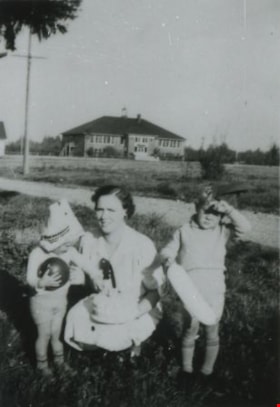
Dunn family
https://search.heritageburnaby.ca/link/archivedescription37683
- Repository
- City of Burnaby Archives
- Date
- October 1937 (date of original), copied 1991
- Collection/Fonds
- Burnaby Historical Society fonds
- Description Level
- Item
- Physical Description
- 1 photograph : b&w ; 4.1 x 2.8 cm print on contact sheet 20.2 x 25.3 cm
- Scope and Content
- Photograph of Ilma Dunn (centre) and her sons, Robert Dunn (left) and Fred Dunn (right), with 2nd Street School in the background. They each have toys in their hands. Robert is wearing a mask pushed to the top of his head.
- Repository
- City of Burnaby Archives
- Date
- October 1937 (date of original), copied 1991
- Collection/Fonds
- Burnaby Historical Society fonds
- Subseries
- Burnaby Image Bank subseries
- Physical Description
- 1 photograph : b&w ; 4.1 x 2.8 cm print on contact sheet 20.2 x 25.3 cm
- Description Level
- Item
- Record No.
- 370-271
- Access Restriction
- No restrictions
- Reproduction Restriction
- No known restrictions
- Accession Number
- BHS1999-03
- Scope and Content
- Photograph of Ilma Dunn (centre) and her sons, Robert Dunn (left) and Fred Dunn (right), with 2nd Street School in the background. They each have toys in their hands. Robert is wearing a mask pushed to the top of his head.
- Subjects
- Buildings - Schools
- Toys
- Media Type
- Photograph
- Notes
- Title based on contents of photograph
- 1 b&w copy negative accompanying
- Negative has a pink cast
- Geographic Access
- 2nd Street
- Street Address
- 7502 2nd Street
- Historic Neighbourhood
- East Burnaby (Historic Neighbourhood)
- Planning Study Area
- Second Street Area
Images

![East Burnaby Methodist Church, [192-] (date of original), copied 1986 thumbnail](/media/hpo/_Data/_Archives_Images/_Unrestricted/204/204-497.jpg?width=280)
East Burnaby Methodist Church
https://search.heritageburnaby.ca/link/archivedescription35639
- Repository
- City of Burnaby Archives
- Date
- [192-] (date of original), copied 1986
- Collection/Fonds
- Burnaby Historical Society fonds
- Description Level
- Item
- Physical Description
- 1 photograph : b&w ; 12.7 x 17.8 cm print
- Scope and Content
- Photograph of East Burnaby Methodist Church, dedicated in June, 1910, and located at the corner of Douglas Road (later Canada Way) and 12th Avenue. It was raised during the time Rev. William Beamish was minister, 1924-1930, and also became part of the United Church of Canada. On the left, the man…
- Repository
- City of Burnaby Archives
- Date
- [192-] (date of original), copied 1986
- Collection/Fonds
- Burnaby Historical Society fonds
- Subseries
- Pioneer Tales subseries
- Physical Description
- 1 photograph : b&w ; 12.7 x 17.8 cm print
- Description Level
- Item
- Record No.
- 204-497
- Access Restriction
- No restrictions
- Reproduction Restriction
- No known restrictions
- Accession Number
- BHS1988-03
- Scope and Content
- Photograph of East Burnaby Methodist Church, dedicated in June, 1910, and located at the corner of Douglas Road (later Canada Way) and 12th Avenue. It was raised during the time Rev. William Beamish was minister, 1924-1930, and also became part of the United Church of Canada. On the left, the manse can be seen on the same lot. The church was torn down in 1956 and a new one built on another property.
- Subjects
- Buildings - Religious - Churches
- Media Type
- Photograph
- Notes
- Title based on contents of photograph
- Geographic Access
- 12th Avenue
- Street Address
- 7707 12th Avenue
- Historic Neighbourhood
- Edmonds (Historic Neighbourhood)
- Planning Study Area
- Edmonds Area
Images
![East Burnaby Methodist Church, [192-] (date of original), copied 1986 thumbnail](/media/hpo/_Data/_Archives_Images/_Unrestricted/204/204-497.jpg)
![First house on Twelfth Avenue, [194-?] (date of original), copied 1991 thumbnail](/media/hpo/_Data/_Archives_Images/_Unrestricted/370/370-782.jpg?width=280)
First house on Twelfth Avenue
https://search.heritageburnaby.ca/link/archivedescription38195
- Repository
- City of Burnaby Archives
- Date
- [194-?] (date of original), copied 1991
- Collection/Fonds
- Burnaby Historical Society fonds
- Description Level
- Item
- Physical Description
- 1 photograph : b&w ; 3.3 x 5.1 cm print on contact sheet 20.3 x 26.6 cm
- Scope and Content
- Photograph of the first house on 12th Avenue, at 160 12th Avenue (later renumbered 8142 12th Avenue).
- Repository
- City of Burnaby Archives
- Date
- [194-?] (date of original), copied 1991
- Collection/Fonds
- Burnaby Historical Society fonds
- Subseries
- Burnaby Image Bank subseries
- Physical Description
- 1 photograph : b&w ; 3.3 x 5.1 cm print on contact sheet 20.3 x 26.6 cm
- Description Level
- Item
- Record No.
- 370-782
- Access Restriction
- No restrictions
- Reproduction Restriction
- Reproduce for fair dealing purposes only
- Accession Number
- BHS1999-03
- Scope and Content
- Photograph of the first house on 12th Avenue, at 160 12th Avenue (later renumbered 8142 12th Avenue).
- Subjects
- Buildings - Residential - Houses
- Media Type
- Photograph
- Notes
- Title based on contents of photograph
- 1 b&w copy negative accompanying
- Geographic Access
- 12th Avenue
- Street Address
- 8142 12th Avenue
- Historic Neighbourhood
- East Burnaby (Historic Neighbourhood)
- Planning Study Area
- Second Street Area
Images
![First house on Twelfth Avenue, [194-?] (date of original), copied 1991 thumbnail](/media/hpo/_Data/_Archives_Images/_Unrestricted/370/370-782.jpg)

House construction on 12th Avenue
https://search.heritageburnaby.ca/link/archivedescription38201
- Repository
- City of Burnaby Archives
- Date
- 1946 (date of original), copied 1991
- Collection/Fonds
- Burnaby Historical Society fonds
- Description Level
- Item
- Physical Description
- 1 photograph : b&w ; 2.9 x 4.9 cm print on contact sheet 20.3 x 26.6 cm
- Scope and Content
- Photograph of the forms for a house under construction at 12th Avenue and 1st Street. A woman is standing at the centre, and a man is at the back left.
- Repository
- City of Burnaby Archives
- Date
- 1946 (date of original), copied 1991
- Collection/Fonds
- Burnaby Historical Society fonds
- Subseries
- Burnaby Image Bank subseries
- Physical Description
- 1 photograph : b&w ; 2.9 x 4.9 cm print on contact sheet 20.3 x 26.6 cm
- Description Level
- Item
- Record No.
- 370-788
- Access Restriction
- No restrictions
- Reproduction Restriction
- No known restrictions
- Accession Number
- BHS1999-03
- Scope and Content
- Photograph of the forms for a house under construction at 12th Avenue and 1st Street. A woman is standing at the centre, and a man is at the back left.
- Media Type
- Photograph
- Notes
- Title based on contents of photograph
- 1 b&w copy negative accompanying
- Geographic Access
- 12th Avenue
- 1st Street
- Historic Neighbourhood
- East Burnaby (Historic Neighbourhood)
- Planning Study Area
- Second Street Area
Images

![Interior of Model Grocery, [1914] date of original, copied [1973] thumbnail](/media/hpo/_Data/_BVM_Images/1973/1973_0098_0003_001.jpg?width=280)
Interior of Model Grocery
https://search.heritageburnaby.ca/link/museumdescription1007
- Repository
- Burnaby Village Museum
- Date
- [1914] date of original, copied [1973]
- Collection/Fonds
- Burnaby Village Museum Photograph collection
- Description Level
- Item
- Physical Description
- 1 photograph : b&w copy negative ; 10 x 12 cm
- Scope and Content
- Photograph of the interior of the Model Grocery store that stood at 2nd Street and 15th Ave, Burnaby. Three men (employees) are standing among the display of goods. An annotation on the back of the photograph identifies them as, left to right, Bill Moore, James Scott and Bill Hay. Some of the pr…
- Repository
- Burnaby Village Museum
- Collection/Fonds
- Burnaby Village Museum Photograph collection
- Description Level
- Item
- Physical Description
- 1 photograph : b&w copy negative ; 10 x 12 cm
- Scope and Content
- Photograph of the interior of the Model Grocery store that stood at 2nd Street and 15th Ave, Burnaby. Three men (employees) are standing among the display of goods. An annotation on the back of the photograph identifies them as, left to right, Bill Moore, James Scott and Bill Hay. Some of the products in view are fresh vegetables and fruits, White Swan Soaps, Robin Hood Porridge Oats, Royal Crown Soaps, Salada tea.
- Geographic Access
- 2nd Street
- 15th Avenue
- Accession Code
- HV973.98.3
- Access Restriction
- No restrictions
- Reproduction Restriction
- May be restricted by third party rights
- Date
- [1914] date of original, copied [1973]
- Media Type
- Photograph
- Historic Neighbourhood
- East Burnaby (Historic Neighbourhood)
- Planning Study Area
- Second Street Area
- Related Material
- According to catalogue record from 1976 and inscription on the back of the photograph, a taped interview with James Scott and Write up about the store are available in the BVM files.
- Scan Resolution
- 600
- Scan Date
- 2023-05-16
- Notes
- Title based on contents of photograph
- The photograph is a master print from negative HV973.98.4.
- Related materials: According to an annotation on the back of the photograph, a taped interview with James Scott [from 1975?] and a write-up about this store are in the Burnaby Village Museum archives
- 20.2 x 25.2 cm print
Images
![Interior of Model Grocery, [1914] date of original, copied [1973] thumbnail](/media/hpo/_Data/_BVM_Images/1973/1973_0098_0003_001.jpg)
![John Burton family home, [1923] thumbnail](/media/Hpo/_Data/_Archives_Images/_Unrestricted/205/216-001.jpg?width=280)
John Burton family home
https://search.heritageburnaby.ca/link/archivedescription36067
- Repository
- City of Burnaby Archives
- Date
- [1923]
- Collection/Fonds
- Burnaby Historical Society fonds
- Description Level
- Item
- Physical Description
- 1 photograph : col. ; 7.5 x 12.5 cm print
- Scope and Content
- Photograph of the John Burton family home at 420 12th Avenue. It was renamed 661 12th Avenue [1925] and later, 7835 12th Avenue.
- Repository
- City of Burnaby Archives
- Date
- [1923]
- Collection/Fonds
- Burnaby Historical Society fonds
- Subseries
- John Burton subseries
- Physical Description
- 1 photograph : col. ; 7.5 x 12.5 cm print
- Description Level
- Item
- Record No.
- 216-001
- Access Restriction
- No restrictions
- Reproduction Restriction
- No known restrictions
- Accession Number
- BHS1989-05
- Scope and Content
- Photograph of the John Burton family home at 420 12th Avenue. It was renamed 661 12th Avenue [1925] and later, 7835 12th Avenue.
- Subjects
- Buildings - Residential - Houses
- Media Type
- Photograph
- Notes
- Title based on contents of photograph
- 1 col. copy negative accompanying
- Accompanying materials state that item no. 216-002 and no. 397-001 are of the same address as this item
- Geographic Access
- 12th Avenue
- Street Address
- 7835 12th Avenue
- Historic Neighbourhood
- Edmonds (Historic Neighbourhood)
- Planning Study Area
- Edmonds Area
Images
![John Burton family home, [1923] thumbnail](/media/Hpo/_Data/_Archives_Images/_Unrestricted/205/216-001.jpg)
![John Burton family home, [between 1940 and 1949] thumbnail](/media/hpo/_Data/_Archives_Images/_Unrestricted/205/216-002.jpg?width=280)
John Burton family home
https://search.heritageburnaby.ca/link/archivedescription36068
- Repository
- City of Burnaby Archives
- Date
- [between 1940 and 1949]
- Collection/Fonds
- Burnaby Historical Society fonds
- Description Level
- Item
- Physical Description
- 1 photograph : col. ; 7.5 x 12.5 cm print
- Scope and Content
- Photograph of the John Burton family home at 661 12th Avenue. It has been renamed 7835 12th Avenue.
- Repository
- City of Burnaby Archives
- Date
- [between 1940 and 1949]
- Collection/Fonds
- Burnaby Historical Society fonds
- Subseries
- John Burton subseries
- Physical Description
- 1 photograph : col. ; 7.5 x 12.5 cm print
- Description Level
- Item
- Record No.
- 216-002
- Access Restriction
- No restrictions
- Reproduction Restriction
- No known restrictions
- Accession Number
- BHS1989-05
- Scope and Content
- Photograph of the John Burton family home at 661 12th Avenue. It has been renamed 7835 12th Avenue.
- Subjects
- Buildings - Residential - Houses
- Media Type
- Photograph
- Notes
- Title based on contents of photograph
- 1 col. copy negative accompanying
- Accompanying materials state that item no. 216-001 and no. 397-001 are of the same address as this item
- Geographic Access
- 12th Avenue
- Street Address
- 7835 12th Avenue
- Historic Neighbourhood
- Edmonds (Historic Neighbourhood)
- Planning Study Area
- Edmonds Area
Images
![John Burton family home, [between 1940 and 1949] thumbnail](/media/hpo/_Data/_Archives_Images/_Unrestricted/205/216-002.jpg)
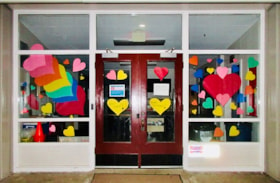
Love for the Workers
https://search.heritageburnaby.ca/link/archivedescription95089
- Repository
- City of Burnaby Archives
- Date
- March 31, 2020
- Collection/Fonds
- Burnaby Photographic Society fonds
- Description Level
- Item
- Physical Description
- 1 photograph (tiff)
- Scope and Content
- Photograph of the entrance to Twelfth Avenue School in Burnaby. The entrance is decorated with colourful paper hearts in support of health care workers. Two yellow hearts on the front doors read "Stay Safe!" and "Distance!" and a red heart above reads "We Miss You!".
- Repository
- City of Burnaby Archives
- Date
- March 31, 2020
- Collection/Fonds
- Burnaby Photographic Society fonds
- Physical Description
- 1 photograph (tiff)
- Description Level
- Item
- Record No.
- 623-008
- Access Restriction
- No restrictions
- Reproduction Restriction
- Reproduce for fair dealing purposes only
- Accession Number
- 2020-10
- Scope and Content
- Photograph of the entrance to Twelfth Avenue School in Burnaby. The entrance is decorated with colourful paper hearts in support of health care workers. Two yellow hearts on the front doors read "Stay Safe!" and "Distance!" and a red heart above reads "We Miss You!".
- Subjects
- Buildings - Schools
- Media Type
- Photograph
- Photographer
- Asbia, Cher
- Notes
- Transcribed title
- Geographic Access
- 12th Avenue
- Street Address
- 7622 12th Avenue
- Historic Neighbourhood
- Edmonds (Historic Neighbourhood)
- Planning Study Area
- Edmonds Area
Images
![Model Grocery, [1914] (date of original), copied [1973] thumbnail](/media/hpo/_Data/_BVM_Images/1973/1973_0098_0001_001.jpg?width=280)
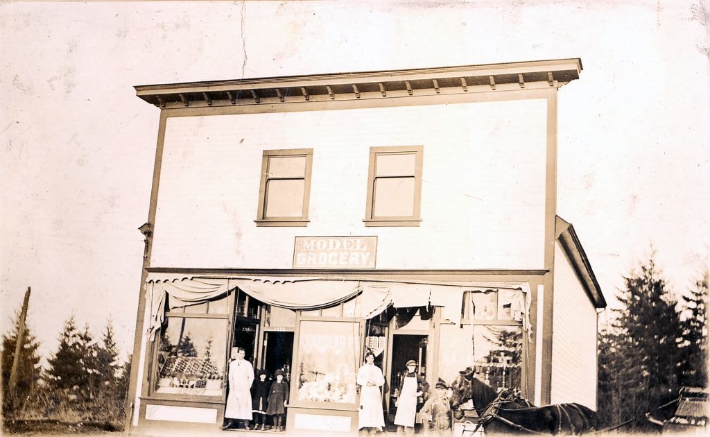
Model Grocery
https://search.heritageburnaby.ca/link/museumdescription3069
- Repository
- Burnaby Village Museum
- Date
- [1914] (date of original), copied [1973]
- Collection/Fonds
- Burnaby Village Museum Photograph collection
- Description Level
- Item
- Physical Description
- 1 photograph : b&w ; 20.1 x 25.1 cm print
- Scope and Content
- Photograph of Bill Hay (on left) and James Scott standing at the front entrance to the Model Grocery Store, situated at 2nd Street and 15th Avenue in Burnaby. The store has wooden shiplap siding all around and a peaked roof with a tall false front with a wide cornice at the top. The righthand side …
- Repository
- Burnaby Village Museum
- Collection/Fonds
- Burnaby Village Museum Photograph collection
- Description Level
- Item
- Physical Description
- 1 photograph : b&w ; 20.1 x 25.1 cm print
- Scope and Content
- Photograph of Bill Hay (on left) and James Scott standing at the front entrance to the Model Grocery Store, situated at 2nd Street and 15th Avenue in Burnaby. The store has wooden shiplap siding all around and a peaked roof with a tall false front with a wide cornice at the top. The righthand side of the eaves show, and the details of the gutter and downspout are clearly visible. The bottom front of the building is all one store. Display windows fill the front in three sections. On the extreme left and right are two wide windows. In the centre is another narrower window. Between these windows are two doors, set in about five feet. A canvas awning (furled) spans the store over the windows. Inside the windows, displays are visible. In the right hand window are stacks of tinned goods. In the centre, flats of fruit set up to face outwards. In the left window is a large display of White Swan soap. Below the right and left windows are small enamelled signs advertising Fleischman's Yeast. No other sign or advertising is visible on the exterior. In the right hand doorway is a display of washboard and corn brooms. A canvas covered horse drawn delivery wagon with a "308 6th St. Model Grocery" sign is positioned to the right rear of the store.
- Geographic Access
- 2nd Street
- 15th Avenue
- Accession Code
- HV973.98.1
- Access Restriction
- No restrictions
- Reproduction Restriction
- May be restricted by third party rights
- Date
- [1914] (date of original), copied [1973]
- Media Type
- Photograph
- Historic Neighbourhood
- East Burnaby (Historic Neighbourhood)
- Planning Study Area
- Second Street Area
- Related Material
- According to catalogue record from 1976, a taped interview with James Scott and Write up about the store are available in the BVM files.
- Scan Resolution
- 600
- Scan Date
- 2023-05-16
- Notes
- Title based on contents of photograph
- See HV973.98.2 for original negative associated with this copy print
- Related materials: According to a note with the photograph, a taped interview with James Scott (1975) and a write-up about this store are in the Burnaby Village Museum archives
Images
![Model Grocery, [1914] (date of original), copied [1973] thumbnail](/media/hpo/_Data/_BVM_Images/1973/1973_0098_0001_001.jpg)

Model Grocery store
https://search.heritageburnaby.ca/link/museumdescription2651
- Repository
- Burnaby Village Museum
- Date
- 1916 (date of original)
- Collection/Fonds
- Burnaby Village Museum Photograph collection
- Description Level
- Item
- Physical Description
- 1 photograph : sepia ; 300 ppi
- Scope and Content
- Photograph of the Model Grocery store in East Burnaby.
- Repository
- Burnaby Village Museum
- Collection/Fonds
- Burnaby Village Museum Photograph collection
- Description Level
- Item
- Physical Description
- 1 photograph : sepia ; 300 ppi
- Scope and Content
- Photograph of the Model Grocery store in East Burnaby.
- Names
- Model Grocery
- Geographic Access
- 2nd Street
- 15th Avenue
- Accession Code
- BV004.115.26
- Access Restriction
- No restrictions
- Date
- 1916 (date of original)
- Media Type
- Photograph
- Historic Neighbourhood
- East Burnaby (Historic Neighbourhood)
- Planning Study Area
- Second Street Area
- Notes
- Title based on contents of photograph
Images

Nordic Centre
https://search.heritageburnaby.ca/link/archivedescription79734
- Repository
- City of Burnaby Archives
- Date
- November 1, 1976
- Collection/Fonds
- Burnaby Public Library Contemporary Visual Archive Project
- Description Level
- Item
- Physical Description
- 1 photograph : b&w ; 11 x 16 cm mounted on cardboard
- Scope and Content
- Photograph shows the Nordic Centre, located on 6th Street on the corner of 12th Avenue. A billboard advertising its services is attached to the side of the building. A few months after this photo was taken, the Nordic Centre was torn down.
- Repository
- City of Burnaby Archives
- Date
- November 1, 1976
- Collection/Fonds
- Burnaby Public Library Contemporary Visual Archive Project
- Physical Description
- 1 photograph : b&w ; 11 x 16 cm mounted on cardboard
- Description Level
- Item
- Record No.
- 556-407
- Access Restriction
- No restrictions
- Reproduction Restriction
- Reproduce for fair dealing purposes only
- Accession Number
- 2013-13
- Scope and Content
- Photograph shows the Nordic Centre, located on 6th Street on the corner of 12th Avenue. A billboard advertising its services is attached to the side of the building. A few months after this photo was taken, the Nordic Centre was torn down.
- Names
- Nordic Centre
- Media Type
- Photograph
- Notes
- Scope note taken directly from BPL photograph description.
- 1 b&w copy negative : 10 x 12.5 cm accompanying
- Photographers identified by surnames only: Carr and Vardeman
- Geographic Access
- 6th Street
- 12th Avenue
- Historic Neighbourhood
- East Burnaby (Historic Neighbourhood)
- Planning Study Area
- Second Street Area
Images

![Second Street Community School garden, [2000] thumbnail](/media/hpo/_Data/_Archives_Images/_Unrestricted/535/535-2425.jpg?width=280)
Second Street Community School garden
https://search.heritageburnaby.ca/link/archivedescription96867
- Repository
- City of Burnaby Archives
- Date
- [2000]
- Collection/Fonds
- Burnaby NewsLeader photograph collection
- Description Level
- Item
- Physical Description
- 1 photograph (tiff) : col.
- Scope and Content
- Photograph of students Amanda Wilkes, Chantal Vicente, and Michael Gerow in the community garden at Second Street Community School.
- Repository
- City of Burnaby Archives
- Date
- [2000]
- Collection/Fonds
- Burnaby NewsLeader photograph collection
- Physical Description
- 1 photograph (tiff) : col.
- Description Level
- Item
- Record No.
- 535-2425
- Access Restriction
- No restrictions
- Reproduction Restriction
- No restrictions
- Accession Number
- 2018-12
- Scope and Content
- Photograph of students Amanda Wilkes, Chantal Vicente, and Michael Gerow in the community garden at Second Street Community School.
- Names
- Second Street School
- Media Type
- Photograph
- Photographer
- Bartel, Mario
- Notes
- Title based on caption
- Collected by editorial for use in a May 2000 issue of the Burnaby NewsLeader
- Caption from metadata: "Amanada Wilkes plants in the garden, while Chantal Vicente and Michael Gerow enjoy a book on a park bench, in the community garden at Second Street Community School. The school recently received a provincial grant to add the benches and other features to the garden."
- Geographic Access
- 2nd Street
- Street Address
- 7502 2nd Street
- Historic Neighbourhood
- East Burnaby (Historic Neighbourhood)
- Planning Study Area
- Second Street Area
Images
![Second Street Community School garden, [2000] thumbnail](/media/hpo/_Data/_Archives_Images/_Unrestricted/535/535-2425.jpg)