Narrow Results By
Subject
- Advertising Medium - Signs and Signboards 1
- Buildings - Religious - Churches 4
- Buildings - Residential 1
- Buildings - Residential - Apartments 3
- Buildings - Residential - Houses 14
- Buildings - Residential - Townhouses 1
- Furniture 1
- Geographic Features - Inlets 1
- Geographic Features - Neighbourhoods 1
- Geographic Features - Roads 4
- Geographic Features - Trails 1
- Transportation - Automobiles 5

Angus & Mabel MacDonald Residence
https://search.heritageburnaby.ca/link/landmark558
- Repository
- Burnaby Heritage Planning
- Description
- Residential building.
- Associated Dates
- 1913
- Other Names
- The Pillars
- Street View URL
- Google Maps Street View
- Repository
- Burnaby Heritage Planning
- Other Names
- The Pillars
- Geographic Access
- Dundas Street
- Associated Dates
- 1913
- Description
- Residential building.
- Heritage Value
- With its two monumental, double height columns terminating in elaborate Ionic capitals, this Neoclassical Revival style house is aptly named The Pillars. Other Neoclassical embellishments include a Palladian pediment window, pilasters with Ionic capitals applied to the front corners of the house and lathe-turned porch columns. Though it has been re-clad with a later covering of asbestos shingles over the original siding, it otherwise retains a high degree of exterior integrity with most of its double-hung windows and decorative elements still in place. This home was constructed for Angus John MacDonald (née Cummins, 1878-1955), Vice-President of A. Linton & Company Ltd., and his wife Mabel Jessie MacDonald (1884-1971). Linton & Company was a shipbuilding firm; MacDonald retired in 1942 after thirty years in the industry. A photograph of this grand house was often featured in the promotional material for the Vancouver Heights subdivision by realtors and titled “A typical Vancouver Heights home.”
- Locality
- Vancouver Heights
- Historic Neighbourhood
- Vancouver Heights (Historic Neighbourhood)
- Planning Study Area
- Burnaby Heights Area
- Area
- 566.71
- Contributing Resource
- Building
- Ownership
- Private
- Street Address
- 3815 Dundas Street
- Street View URL
- Google Maps Street View
Images


Harrison & Beatrice Morrison Residence
https://search.heritageburnaby.ca/link/landmark589
- Repository
- Burnaby Heritage Planning
- Description
- Residential building.
- Associated Dates
- 1911
- Street View URL
- Google Maps Street View
- Repository
- Burnaby Heritage Planning
- Geographic Access
- Dundas Street
- Associated Dates
- 1911
- Description
- Residential building.
- Heritage Value
- In 1911, the Vancouver Daily Province reported that “Mr. Harrison D. Morrison is building a twelve-room house of two stories and an attic, with stone basement, on Dundas Street, at a cost of about $4,500.” Harrison Donald Morrison (1864-1944) was a life-long contractor who lived in Burnaby with his wife Beatrice Amanda (née Smith, 1875-1954), until his death in 1944. This Edwardian-era house displays many holdover elements of the Queen Anne Revival style, particularly the elaboration of wall surfaces. In this example, the use of bay and cutaway bay windows, and integral first and second storey verandahs–now removed or altered–add visual interest. The distinct dual pitch of the roof is also a transitional characteristic, used in the late days of the Queen Anne Revival style. A later coat of stucco now covers the original ground floor siding.
- Locality
- Vancouver Heights
- Historic Neighbourhood
- Vancouver Heights (Historic Neighbourhood)
- Planning Study Area
- Burnaby Heights Area
- Area
- 566.71
- Contributing Resource
- Building
- Ownership
- Private
- Street Address
- 3738 Dundas Street
- Street View URL
- Google Maps Street View
Images


H.D. Morrison House
https://search.heritageburnaby.ca/link/landmark521
- Repository
- Burnaby Heritage Planning
- Description
- The H.D. Morrison House is a tall, two and one-half storey plus basement wood-frame Edwardian era residence, with an eclectic combination of Arts and Crafts stylistic elements. It is now located adjacent to a large multi-family residential building in the Vancouver Heights neighbourhood of North Bu…
- Associated Dates
- 1912
- Formal Recognition
- Heritage Designation, Community Heritage Register
- Other Names
- Harrison D. Morrison House
- Street View URL
- Google Maps Street View
- Repository
- Burnaby Heritage Planning
- Other Names
- Harrison D. Morrison House
- Geographic Access
- Albert Street
- Associated Dates
- 1912
- Formal Recognition
- Heritage Designation, Community Heritage Register
- Enactment Type
- Bylaw No. 10626
- Enactment Date
- 22/09/1997
- Description
- The H.D. Morrison House is a tall, two and one-half storey plus basement wood-frame Edwardian era residence, with an eclectic combination of Arts and Crafts stylistic elements. It is now located adjacent to a large multi-family residential building in the Vancouver Heights neighbourhood of North Burnaby.
- Heritage Value
- The H.D. Morrison House is valued for its association with the initial speculative development phase of the Vancouver Heights neighbourhood, initiated during the Edwardian era as a high-class residential subdivision. Building contractor Harrison D. Morrison built this house as a rental property in 1912, at the height of the land speculation boom prior to the First World War. Buyers in the neighbourhood were obligated by the developer, G.F. and J. Galt Limited, to build houses worth a minimum of $3,500 at a time when the average house price was $1,000. Additionally, the H.D. Morrison House is a typical example of builders' houses of the time period, distinguished by the unique stacked balconies on the front facade. It was one of the surviving landmark residences built between 1909 and 1914 during the first development boom in Vancouver Heights.
- Defining Elements
- Key elements that define the heritage character of the H.D. Morrison House include its: - location on a south-facing slope in the Vancouver Heights neighbourhood of North Burnaby - residential form, scale and massing as exemplified by its symmetrical two and one-half storey plus basement height, front gabled roof and rectangular plan - vernacular Arts and Crafts style elements such as the exposed roof beams and rafter tails, decorative scalloped shingles in the front gable and decorative brackets - main floor full open front verandah on the front facade with two stacked balconies above, all detailed with square columns, scroll-cut brackets and overhanging roof eaves - bowed balustrade on main floor verandah - boxed eaves with scroll-cut brackets - recessed top floor gable treatment - cladding, including lapped wooden siding at the main floor and cedar shingles on the second floor and in the gable ends, with decorative diamond-cut shingles in the front gable end - front entry door with incised design, dentil detail and rectangular glass inset, with glassed sidelights - irregular fenestration: double-hung 1-over-1 wooden-sash windows; and three part casement window on main floor front facade, with diamond-shaped leaded lights in double transom above - corbelled red brick internal chimney
- Historic Neighbourhood
- Vancouver Heights (Historic Neighbourhood)
- Planning Study Area
- Burnaby Heights Area
- Function
- Primary Historic--Single Dwelling
- Primary Current--Multiple Dwelling
- Community
- Burnaby
- Cadastral Identifier
- 003-318-371
- Boundaries
- The H.D. Morrison House is comprised of a single residential lot located at 3765 Albert Street, Burnaby.
- Area
- 2263
- Contributing Resource
- Building
- Ownership
- Private
- Street Address
- 3765 Albert Street
- Street View URL
- Google Maps Street View
Images


John & Roseanna Clark House
https://search.heritageburnaby.ca/link/landmark567
- Repository
- Burnaby Heritage Planning
- Description
- Residential building.
- Associated Dates
- 1912
- Formal Recognition
- Heritage Designation, Community Heritage Register
- Street View URL
- Google Maps Street View
- Repository
- Burnaby Heritage Planning
- Geographic Access
- Dundas Street
- Associated Dates
- 1912
- Formal Recognition
- Heritage Designation, Community Heritage Register
- Enactment Type
- Bylaw No. 12640
- Enactment Date
- 22/06/2009
- Description
- Residential building.
- Heritage Value
- While simple in form, this sophisticated Edwardian-era house is finely detailed and maintains a high degree of its original integrity. The symmetrical home’s most distinct characteristic is its full width inset verandah with octagonal columns supporting second floor projection. This was the home of John William Clark (1886-1947), an English-born carpenter who retired in 1926, and his wife Roseanna Clark (1860-1933).
- Locality
- Vancouver Heights
- Historic Neighbourhood
- Vancouver Heights (Historic Neighbourhood)
- Planning Study Area
- Burnaby Heights Area
- Community
- Burnaby
- Contributing Resource
- Building
- Ownership
- Private
- Street Address
- 4115 Dundas Street
- Street View URL
- Google Maps Street View
Images


3717-3763 Albert Street
https://search.heritageburnaby.ca/link/archivedescription93763
- Repository
- City of Burnaby Archives
- Date
- June 26, 1992
- Collection/Fonds
- Grover, Elliott & Co. Ltd. fonds
- Description Level
- File
- Physical Description
- 16 photographs : col. negatives ; 35 mm
- Scope and Content
- Photographs of the residential houses and laneways located at 3717-3763 Albert Street - addresses that no longer exist. The property's current address is 3755 Albert Street.
- Repository
- City of Burnaby Archives
- Date
- June 26, 1992
- Collection/Fonds
- Grover, Elliott & Co. Ltd. fonds
- Physical Description
- 16 photographs : col. negatives ; 35 mm
- Description Level
- File
- Record No.
- 622-048
- Access Restriction
- No restrictions
- Reproduction Restriction
- No restrictions
- Accession Number
- 2017-39
- Scope and Content
- Photographs of the residential houses and laneways located at 3717-3763 Albert Street - addresses that no longer exist. The property's current address is 3755 Albert Street.
- Subjects
- Buildings - Residential - Houses
- Media Type
- Photograph
- Photographer
- Young, Richard
- Notes
- Transcribed title
- Title transcribed from envelope photographs were originally housed in
- File no. 92-247-B
- Geographic Access
- Albert Street
- Street Address
- 3755 Albert Street
- Historic Neighbourhood
- Vancouver Heights (Historic Neighbourhood)
- Planning Study Area
- Burnaby Heights Area
![3900 Albert Street, [between 1965 and 1970] thumbnail](/media/hpo/_Data/_Archives_Images/_Unrestricted/316/366-018.jpg?width=280)
3900 Albert Street
https://search.heritageburnaby.ca/link/archivedescription37389
- Repository
- City of Burnaby Archives
- Date
- [between 1965 and 1970]
- Collection/Fonds
- Burnaby Historical Society fonds
- Description Level
- Item
- Physical Description
- 1 photograph : b&w negative
- Scope and Content
- Photograph of the north side of 3900 Albert Street, looking west. The Vancouver Heights Baptist Church can be seen to the far right (at the corner of Albert Street and Ingleton Avenue).
- Repository
- City of Burnaby Archives
- Date
- [between 1965 and 1970]
- Collection/Fonds
- Burnaby Historical Society fonds
- Subseries
- Municipal record subseries
- Physical Description
- 1 photograph : b&w negative
- Description Level
- Item
- Record No.
- 366-018
- Access Restriction
- No restrictions
- Reproduction Restriction
- Reproduce for fair dealing purposes only
- Accession Number
- BHS1998-12
- Scope and Content
- Photograph of the north side of 3900 Albert Street, looking west. The Vancouver Heights Baptist Church can be seen to the far right (at the corner of Albert Street and Ingleton Avenue).
- Media Type
- Photograph
- Notes
- Title based on contents of photograph
- Geographic Access
- Ingleton Avenue
- Albert Street
- Street Address
- 3900 Albert Street
- 271 Ingleton Avenue
- 3977 Albert Street
- Historic Neighbourhood
- Vancouver Heights (Historic Neighbourhood)
- Planning Study Area
- Burnaby Heights Area
Images
![3900 Albert Street, [between 1965 and 1970] thumbnail](/media/hpo/_Data/_Archives_Images/_Unrestricted/316/366-018.jpg)
![3900 Albert Street at Ingleton Avenue, [between 1965 and 1970] thumbnail](/media/hpo/_Data/_Archives_Images/_Unrestricted/316/366-019.jpg?width=280)
3900 Albert Street at Ingleton Avenue
https://search.heritageburnaby.ca/link/archivedescription37390
- Repository
- City of Burnaby Archives
- Date
- [between 1965 and 1970]
- Collection/Fonds
- Burnaby Historical Society fonds
- Description Level
- Item
- Physical Description
- 1 photograph : b&w negative
- Scope and Content
- Photograph looking west along the north side of Albert Street from the 3900 Block. At the far right can be seen the Vancouver Heights Baptist Church, at the intersection of Albert and Ingleton Avenue.
- Repository
- City of Burnaby Archives
- Date
- [between 1965 and 1970]
- Collection/Fonds
- Burnaby Historical Society fonds
- Subseries
- Municipal record subseries
- Physical Description
- 1 photograph : b&w negative
- Description Level
- Item
- Record No.
- 366-019
- Access Restriction
- No restrictions
- Reproduction Restriction
- Reproduce for fair dealing purposes only
- Accession Number
- BHS1998-12
- Scope and Content
- Photograph looking west along the north side of Albert Street from the 3900 Block. At the far right can be seen the Vancouver Heights Baptist Church, at the intersection of Albert and Ingleton Avenue.
- Media Type
- Photograph
- Notes
- Title based on contents of photograph.
- Geographic Access
- Albert Street
- Ingleton Avenue
- Street Address
- 3900 Albert Street
- 271 Ingleton Avenue
- Historic Neighbourhood
- Vancouver Heights (Historic Neighbourhood)
- Planning Study Area
- Burnaby Heights Area
Images
![3900 Albert Street at Ingleton Avenue, [between 1965 and 1970] thumbnail](/media/hpo/_Data/_Archives_Images/_Unrestricted/316/366-019.jpg)
![3900 Albert Street - South Side, [196-] thumbnail](/media/hpo/_Data/_Archives_Images/_Unrestricted/316/366-027.jpg?width=280)
3900 Albert Street - South Side
https://search.heritageburnaby.ca/link/archivedescription97610
- Repository
- City of Burnaby Archives
- Date
- [196-]
- Collection/Fonds
- Burnaby Historical Society fonds
- Description Level
- Item
- Physical Description
- 1 photograph : b&w negative
- Scope and Content
- Photograph of two houses on the south corner of Albert Street and Ingleton Avenue at 3900 Albert Street.
- Repository
- City of Burnaby Archives
- Date
- [196-]
- Collection/Fonds
- Burnaby Historical Society fonds
- Subseries
- Municipal record subseries
- Physical Description
- 1 photograph : b&w negative
- Description Level
- Item
- Record No.
- 366-027
- Access Restriction
- No restrictions
- Reproduction Restriction
- Reproduce for fair dealing purposes only
- Accession Number
- BHS1998-12
- Scope and Content
- Photograph of two houses on the south corner of Albert Street and Ingleton Avenue at 3900 Albert Street.
- Subjects
- Buildings - Residential - Houses
- Media Type
- Photograph
- Notes
- Transcribed title
- Note on verso of photograph in black ink reads: "3900 Albert - South Side - Two Houses at East End of Block"
- Geographic Access
- Albert Street
- Street Address
- 3900 Albert Street
- Historic Neighbourhood
- Vancouver Heights (Historic Neighbourhood)
- Planning Study Area
- Burnaby Heights Area
Images
![3900 Albert Street - South Side, [196-] thumbnail](/media/hpo/_Data/_Archives_Images/_Unrestricted/316/366-027.jpg)
![3980 Albert Street, [between 1965 and 1970] thumbnail](/media/hpo/_Data/_Archives_Images/_Unrestricted/316/366-024.jpg?width=280)
3980 Albert Street
https://search.heritageburnaby.ca/link/archivedescription37395
- Repository
- City of Burnaby Archives
- Date
- [between 1965 and 1970]
- Collection/Fonds
- Burnaby Historical Society fonds
- Description Level
- Item
- Physical Description
- 1 photograph : b&w negative
- Scope and Content
- Photograph of the home located at 3980 Albert Street (old street number).
- Repository
- City of Burnaby Archives
- Date
- [between 1965 and 1970]
- Collection/Fonds
- Burnaby Historical Society fonds
- Subseries
- Municipal record subseries
- Physical Description
- 1 photograph : b&w negative
- Description Level
- Item
- Record No.
- 366-024
- Access Restriction
- No restrictions
- Reproduction Restriction
- Reproduce for fair dealing purposes only
- Accession Number
- BHS1998-12
- Scope and Content
- Photograph of the home located at 3980 Albert Street (old street number).
- Subjects
- Buildings - Residential - Houses
- Media Type
- Photograph
- Notes
- Title based on contents of photograph
- Geographic Access
- Albert Street
- Historic Neighbourhood
- Vancouver Heights (Historic Neighbourhood)
- Planning Study Area
- Burnaby Heights Area
Images
![3980 Albert Street, [between 1965 and 1970] thumbnail](/media/hpo/_Data/_Archives_Images/_Unrestricted/316/366-024.jpg)
![3980 Albert Street, [between 1965 and 1970] thumbnail](/media/hpo/_Data/_Archives_Images/_Unrestricted/316/366-025.jpg?width=280)
3980 Albert Street
https://search.heritageburnaby.ca/link/archivedescription37396
- Repository
- City of Burnaby Archives
- Date
- [between 1965 and 1970]
- Collection/Fonds
- Burnaby Historical Society fonds
- Description Level
- Item
- Physical Description
- 1 photograph : b&w negative
- Scope and Content
- Photograph of a house located at 3980 Albert Street (old street number).
- Repository
- City of Burnaby Archives
- Date
- [between 1965 and 1970]
- Collection/Fonds
- Burnaby Historical Society fonds
- Subseries
- Municipal record subseries
- Physical Description
- 1 photograph : b&w negative
- Description Level
- Item
- Record No.
- 366-025
- Access Restriction
- No restrictions
- Reproduction Restriction
- Reproduce for fair dealing purposes only
- Accession Number
- BHS1998-12
- Scope and Content
- Photograph of a house located at 3980 Albert Street (old street number).
- Subjects
- Buildings - Residential - Houses
- Media Type
- Photograph
- Notes
- Title based on contents of photograph
- Geographic Access
- Albert Street
- Historic Neighbourhood
- Vancouver Heights (Historic Neighbourhood)
- Planning Study Area
- Burnaby Heights Area
Images
![3980 Albert Street, [between 1965 and 1970] thumbnail](/media/hpo/_Data/_Archives_Images/_Unrestricted/316/366-025.jpg)

4297 Albert Street
https://search.heritageburnaby.ca/link/archivedescription37591
- Repository
- City of Burnaby Archives
- Date
- 1951 (date of original), copied 1991
- Collection/Fonds
- Burnaby Historical Society fonds
- Description Level
- Item
- Physical Description
- 1 photograph : b&w ; 2.7 x 4.2 cm print on contact sheet 20.2 x 25.3 cm
- Scope and Content
- Photograph of 4297 Albert Street. Another house is visible in the background.
- Repository
- City of Burnaby Archives
- Date
- 1951 (date of original), copied 1991
- Collection/Fonds
- Burnaby Historical Society fonds
- Subseries
- Burnaby Image Bank subseries
- Physical Description
- 1 photograph : b&w ; 2.7 x 4.2 cm print on contact sheet 20.2 x 25.3 cm
- Description Level
- Item
- Record No.
- 370-179
- Access Restriction
- No restrictions
- Reproduction Restriction
- No restrictions
- Accession Number
- BHS1999-03
- Scope and Content
- Photograph of 4297 Albert Street. Another house is visible in the background.
- Subjects
- Buildings - Residential - Houses
- Media Type
- Photograph
- Notes
- Title based on contents of photograph
- 1 b&w copy negative accompanying
- Negative has a pink cast
- Geographic Access
- Albert Street
- Street Address
- 4297 Albert Street
- Historic Neighbourhood
- Vancouver Heights (Historic Neighbourhood)
- Planning Study Area
- Burnaby Heights Area
Images


4297 Albert Street
https://search.heritageburnaby.ca/link/archivedescription37592
- Repository
- City of Burnaby Archives
- Date
- 1950 (date of original), copied 1991
- Collection/Fonds
- Burnaby Historical Society fonds
- Description Level
- Item
- Physical Description
- 1 photograph : b&w ; 3.4 x 3.5 cm print on contact sheet 20.2 x 25.3 cm
- Scope and Content
- Photograph of 4297 Albert Street.
- Repository
- City of Burnaby Archives
- Date
- 1950 (date of original), copied 1991
- Collection/Fonds
- Burnaby Historical Society fonds
- Subseries
- Burnaby Image Bank subseries
- Physical Description
- 1 photograph : b&w ; 3.4 x 3.5 cm print on contact sheet 20.2 x 25.3 cm
- Description Level
- Item
- Record No.
- 370-180
- Access Restriction
- No restrictions
- Reproduction Restriction
- No restrictions
- Accession Number
- BHS1999-03
- Scope and Content
- Photograph of 4297 Albert Street.
- Subjects
- Buildings - Residential - Houses
- Media Type
- Photograph
- Notes
- Title based on contents of photograph
- 1 b&w copy negative accompanying
- Negative has a pink cast
- Geographic Access
- Albert Street
- Street Address
- 4297 Albert Street
- Historic Neighbourhood
- Vancouver Heights (Historic Neighbourhood)
- Planning Study Area
- Burnaby Heights Area
Images


Apartment at Albert and Ingleton
https://search.heritageburnaby.ca/link/archivedescription79031
- Repository
- City of Burnaby Archives
- Date
- September 12, 1976
- Collection/Fonds
- Burnaby Public Library Contemporary Visual Archive Project
- Description Level
- Item
- Physical Description
- 1 photograph : b&w ; 11 x 16 cm mounted on cardboard
- Scope and Content
- Photograph shows a sign on an apartment building on Albert Street near Ingleton Avenue.
- Repository
- City of Burnaby Archives
- Date
- September 12, 1976
- Collection/Fonds
- Burnaby Public Library Contemporary Visual Archive Project
- Physical Description
- 1 photograph : b&w ; 11 x 16 cm mounted on cardboard
- Description Level
- Item
- Record No.
- 556-102
- Access Restriction
- No restrictions
- Reproduction Restriction
- Reproduce for fair dealing purposes only
- Accession Number
- 2013-13
- Scope and Content
- Photograph shows a sign on an apartment building on Albert Street near Ingleton Avenue.
- Media Type
- Photograph
- Notes
- Scope note taken directly from BPL photograph description.
- 1 b&w copy negative : 10 x 12.5 cm accompanying
- Photographers identified by surnames only: Carr and Vardeman
- Geographic Access
- Albert Street
- Ingleton Avenue
- Historic Neighbourhood
- Vancouver Heights (Historic Neighbourhood)
- Planning Study Area
- Burnaby Heights Area
Images

![Bessie and Helen Stack, [192-] (date of original), copied 1992 thumbnail](/media/hpo/_Data/_Archives_Images/_Unrestricted/315/315-478.jpg?width=280)
Bessie and Helen Stack
https://search.heritageburnaby.ca/link/archivedescription37015
- Repository
- City of Burnaby Archives
- Date
- [192-] (date of original), copied 1992
- Collection/Fonds
- Burnaby Historical Society fonds
- Description Level
- Item
- Physical Description
- 1 photograph : b&w ; 8.3 x 11.4 cm print
- Scope and Content
- Photograph of sisters Elizabeth "Bessie" and Helen Stack outside their home on the 3900 block of Albert Street.
- Repository
- City of Burnaby Archives
- Date
- [192-] (date of original), copied 1992
- Collection/Fonds
- Burnaby Historical Society fonds
- Subseries
- Burnaby Centennial Anthology subseries
- Physical Description
- 1 photograph : b&w ; 8.3 x 11.4 cm print
- Description Level
- Item
- Record No.
- 315-478
- Access Restriction
- No restrictions
- Reproduction Restriction
- No known restrictions
- Accession Number
- BHS1994-04
- Scope and Content
- Photograph of sisters Elizabeth "Bessie" and Helen Stack outside their home on the 3900 block of Albert Street.
- Media Type
- Photograph
- Notes
- Title based on contents of photograph
- Geographic Access
- Albert Street
- Historic Neighbourhood
- Vancouver Heights (Historic Neighbourhood)
- Planning Study Area
- Burnaby Heights Area
Images
![Bessie and Helen Stack, [192-] (date of original), copied 1992 thumbnail](/media/hpo/_Data/_Archives_Images/_Unrestricted/315/315-478.jpg)
Bradbury family home
https://search.heritageburnaby.ca/link/archivedescription35377
- Repository
- City of Burnaby Archives
- Date
- 1927 (date of original), copied 1986
- Collection/Fonds
- Burnaby Historical Society fonds
- Description Level
- Item
- Physical Description
- 1 photograph : b&w ; 12.7 x 17.8 cm print
- Scope and Content
- Photograph of the Percival Bradbury family home in the 4100 block of Albert Street, North Burnaby. Percival was married to Kate Bradbury and settled in Burnaby in 1927. Later, the family moved south of Hastings Street.
- Repository
- City of Burnaby Archives
- Date
- 1927 (date of original), copied 1986
- Collection/Fonds
- Burnaby Historical Society fonds
- Subseries
- Pioneer Tales subseries
- Physical Description
- 1 photograph : b&w ; 12.7 x 17.8 cm print
- Description Level
- Item
- Record No.
- 204-234
- Access Restriction
- No restrictions
- Reproduction Restriction
- No known restrictions
- Accession Number
- BHS1988-03
- Scope and Content
- Photograph of the Percival Bradbury family home in the 4100 block of Albert Street, North Burnaby. Percival was married to Kate Bradbury and settled in Burnaby in 1927. Later, the family moved south of Hastings Street.
- Subjects
- Buildings - Residential - Houses
- Media Type
- Photograph
- Notes
- Title based on contents of photograph
- Geographic Access
- Albert Street
- Historic Neighbourhood
- Vancouver Heights (Historic Neighbourhood)
- Planning Study Area
- Burnaby Heights Area
Images


Burnaby North Baptist Church
https://search.heritageburnaby.ca/link/archivedescription79055
- Repository
- City of Burnaby Archives
- Date
- September 12, 1976
- Collection/Fonds
- Burnaby Public Library Contemporary Visual Archive Project
- Description Level
- Item
- Physical Description
- 1 photograph : b&w ; 11 x 16 cm mounted on cardboard
- Scope and Content
- Photograph shows the Burnaby North Baptist Church at 3977 Albert Street on the corner of MacDonald Avenue.
- Repository
- City of Burnaby Archives
- Date
- September 12, 1976
- Collection/Fonds
- Burnaby Public Library Contemporary Visual Archive Project
- Physical Description
- 1 photograph : b&w ; 11 x 16 cm mounted on cardboard
- Description Level
- Item
- Record No.
- 556-121
- Access Restriction
- No restrictions
- Reproduction Restriction
- Reproduce for fair dealing purposes only
- Accession Number
- 2013-13
- Scope and Content
- Photograph shows the Burnaby North Baptist Church at 3977 Albert Street on the corner of MacDonald Avenue.
- Subjects
- Buildings - Religious - Churches
- Media Type
- Photograph
- Notes
- Scope note taken directly from BPL photograph description.
- 1 b&w copy negative : 10 x 12.5 cm accompanying
- Photographers identified by surnames only: Carr and Vardeman
- Geographic Access
- Albert Street
- Street Address
- 3977 Albert Street
- Historic Neighbourhood
- Vancouver Heights (Historic Neighbourhood)
- Planning Study Area
- Burnaby Heights Area
Images

![Carol and Valerie Shantz with Ida Cary, [1955] (date of original), copied 1991 thumbnail](/media/hpo/_Data/_Archives_Images/_Unrestricted/370/370-167.jpg?width=280)
Carol and Valerie Shantz with Ida Cary
https://search.heritageburnaby.ca/link/archivedescription37579
- Repository
- City of Burnaby Archives
- Date
- [1955] (date of original), copied 1991
- Collection/Fonds
- Burnaby Historical Society fonds
- Description Level
- Item
- Physical Description
- 1 photograph : b&w ; 4.4 x 3.0 cm print on contact sheet 20.2 x 25.3 cm
- Scope and Content
- Photograph of Carol and Valerie Shantz, age 5 and 1, with their grandmother, Ida Cary, at the intersection of Madison Avenue and Albert Street.
- Repository
- City of Burnaby Archives
- Date
- [1955] (date of original), copied 1991
- Collection/Fonds
- Burnaby Historical Society fonds
- Subseries
- Burnaby Image Bank subseries
- Physical Description
- 1 photograph : b&w ; 4.4 x 3.0 cm print on contact sheet 20.2 x 25.3 cm
- Description Level
- Item
- Record No.
- 370-167
- Access Restriction
- No restrictions
- Reproduction Restriction
- No restrictions
- Accession Number
- BHS1999-03
- Scope and Content
- Photograph of Carol and Valerie Shantz, age 5 and 1, with their grandmother, Ida Cary, at the intersection of Madison Avenue and Albert Street.
- Subjects
- Geographic Features - Neighbourhoods
- Media Type
- Photograph
- Notes
- Title based on contents of photograph
- 1 b&w copy negative accompanying
- Geographic Access
- Madison Avenue
- Albert Street
- Historic Neighbourhood
- Vancouver Heights (Historic Neighbourhood)
- Planning Study Area
- Burnaby Heights Area
Images
![Carol and Valerie Shantz with Ida Cary, [1955] (date of original), copied 1991 thumbnail](/media/hpo/_Data/_Archives_Images/_Unrestricted/370/370-167.jpg)
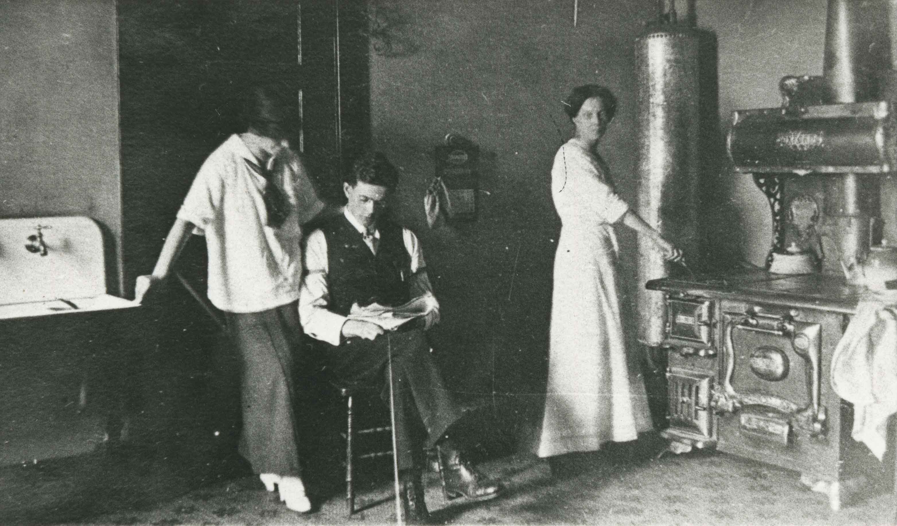
Clarice Wilks and Dr. Carl Eaton
https://search.heritageburnaby.ca/link/archivedescription35446
- Repository
- City of Burnaby Archives
- Date
- 1916 (date of original), copied 1986
- Collection/Fonds
- Burnaby Historical Society fonds
- Description Level
- Item
- Physical Description
- 1 photograph : b&w ; 12.7 x 17.8 cm print
- Scope and Content
- Photograph of (left to right) Clarice Wilks (later Clarice Eaton), Dr. Carl Eaton and an unidentified woman, taken in the kitchen of the Wilks home, 3707 Dundas Street. Dr. Eaton took this picture himself by tripping shutter with the string visible in his hand.
- Repository
- City of Burnaby Archives
- Date
- 1916 (date of original), copied 1986
- Collection/Fonds
- Burnaby Historical Society fonds
- Subseries
- Pioneer Tales subseries
- Physical Description
- 1 photograph : b&w ; 12.7 x 17.8 cm print
- Description Level
- Item
- Record No.
- 204-304
- Access Restriction
- No restrictions
- Reproduction Restriction
- No restrictions
- Accession Number
- BHS1988-03
- Scope and Content
- Photograph of (left to right) Clarice Wilks (later Clarice Eaton), Dr. Carl Eaton and an unidentified woman, taken in the kitchen of the Wilks home, 3707 Dundas Street. Dr. Eaton took this picture himself by tripping shutter with the string visible in his hand.
- Subjects
- Furniture
- Media Type
- Photograph
- Photographer
- Eaton, Dr. Carl
- Notes
- Title based on contents of photograph
- Note under photograph reads, "Taken by string in the kitchen - 1916"
- Geographic Access
- Dundas Street
- Street Address
- 3707 Dundas Street
- Historic Neighbourhood
- Vancouver Heights (Historic Neighbourhood)
- Planning Study Area
- Burnaby Heights Area
Images
![Cranberry Commons, [2002] thumbnail](/media/hpo/_Data/_Archives_Images/_Unrestricted/535/535-2517-1.jpg?width=280)
Cranberry Commons
https://search.heritageburnaby.ca/link/archivedescription96962
- Repository
- City of Burnaby Archives
- Date
- [2002]
- Collection/Fonds
- Burnaby NewsLeader photograph collection
- Description Level
- File
- Physical Description
- 2 photographs (tiff) : b&w and col.
- Scope and Content
- File contains photographs of Ronaye Mathew at Cranberry Commons, a cohousing development in North Burnaby that received an Environment Award from the City of Burnaby. Photographs depict Mathew in the development's courtyard and posing in the communal kitchen.
- Repository
- City of Burnaby Archives
- Date
- [2002]
- Collection/Fonds
- Burnaby NewsLeader photograph collection
- Physical Description
- 2 photographs (tiff) : b&w and col.
- Description Level
- File
- Record No.
- 535-2517
- Access Restriction
- No restrictions
- Reproduction Restriction
- No restrictions
- Accession Number
- 2018-12
- Scope and Content
- File contains photographs of Ronaye Mathew at Cranberry Commons, a cohousing development in North Burnaby that received an Environment Award from the City of Burnaby. Photographs depict Mathew in the development's courtyard and posing in the communal kitchen.
- Subjects
- Buildings - Residential - Apartments
- Buildings - Residential
- Buildings - Residential - Townhouses
- Media Type
- Photograph
- Photographer
- Bartel, Mario
- Notes
- Title based on caption
- Collected by editorial for use in a June 2002 issue of the Burnaby NewsLeader
- Caption from metadata for 535-2517-1: "Ronaye Mathew relaxes in the central courtyard at Cranberry Commons, a cohousing development in North Burnaby that's been honoured by the city with an Environment Award."
- Caption from metadata for 535-2517-2: "Ronaye Mathew enjoys a rare moment of peace in the communal kitchen at Cranberry Commons, a cohousing development in North Burnaby. At least three times a week, the kitchen is crowded for communal dinners. The development has been honored by the City with an Environment Award."
- Geographic Access
- Albert Street
- Street Address
- 4272 Albert Street
- Historic Neighbourhood
- Vancouver Heights (Historic Neighbourhood)
- Planning Study Area
- Burnaby Heights Area
Images
![Cranberry Commons, [2002] thumbnail](/media/hpo/_Data/_Archives_Images/_Unrestricted/535/535-2517-1.jpg)
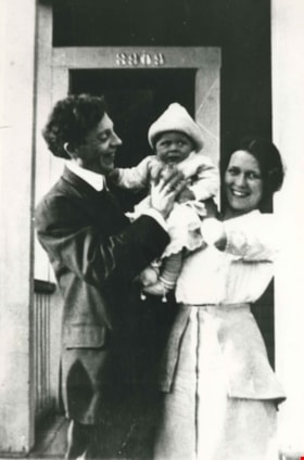
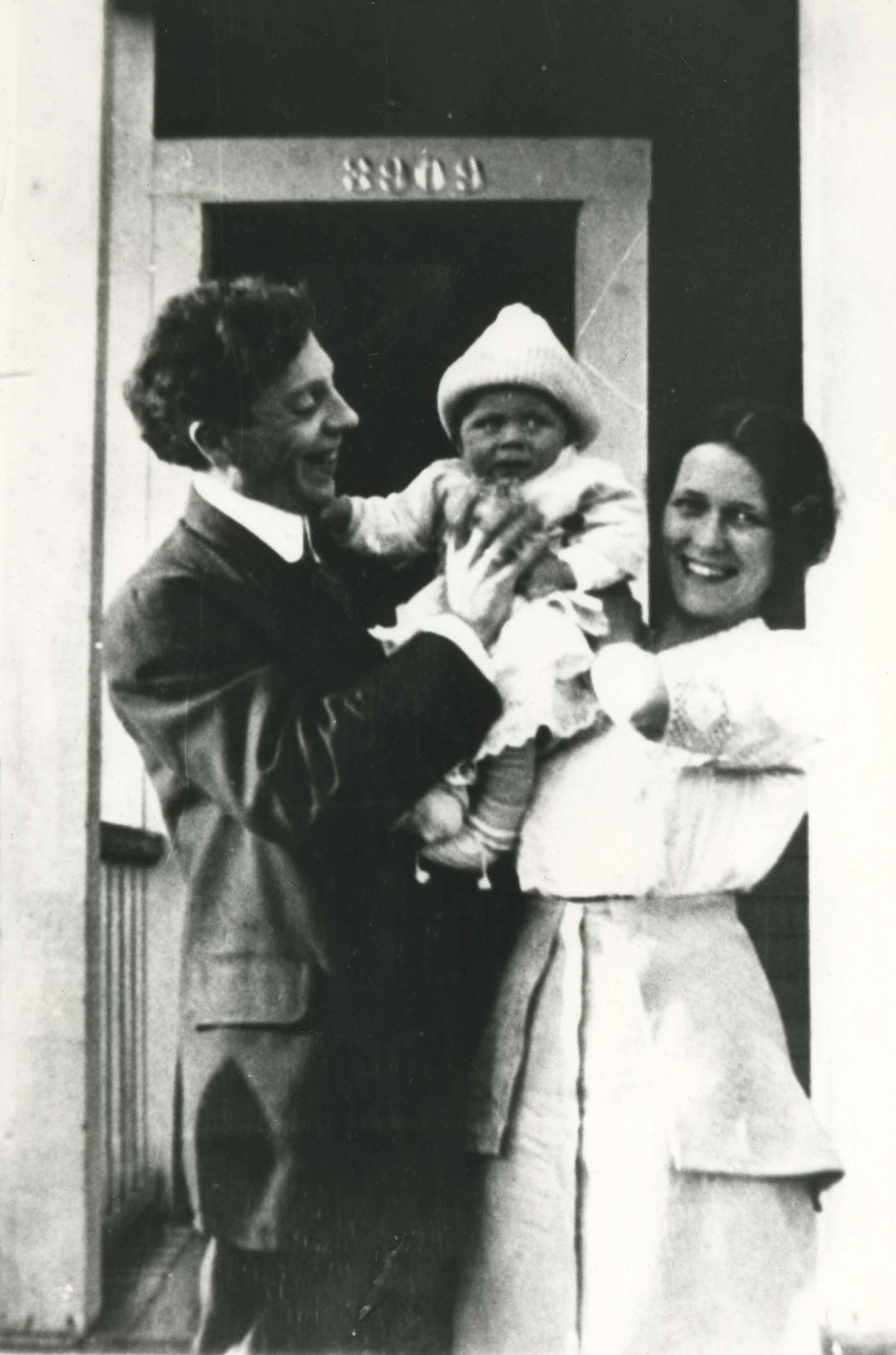
Donovan family
https://search.heritageburnaby.ca/link/archivedescription35588
- Repository
- City of Burnaby Archives
- Date
- 1913 (date of original), copied 1986
- Collection/Fonds
- Burnaby Historical Society fonds
- Description Level
- Item
- Physical Description
- 1 photograph : b&w ; 12.7 x 17.8 cm print
- Scope and Content
- Photograph of the Donovan family. Left to right: George L. Donovan (father), George Donovan (son), and Laura Elizabeth Donovan (mother). The photograph was taken in front of their first Burnaby family home, 3909 Albert Street, Vancouver Heights.
- Repository
- City of Burnaby Archives
- Date
- 1913 (date of original), copied 1986
- Collection/Fonds
- Burnaby Historical Society fonds
- Subseries
- Pioneer Tales subseries
- Physical Description
- 1 photograph : b&w ; 12.7 x 17.8 cm print
- Description Level
- Item
- Record No.
- 204-446
- Access Restriction
- No restrictions
- Reproduction Restriction
- No known restrictions
- Accession Number
- BHS1988-03
- Scope and Content
- Photograph of the Donovan family. Left to right: George L. Donovan (father), George Donovan (son), and Laura Elizabeth Donovan (mother). The photograph was taken in front of their first Burnaby family home, 3909 Albert Street, Vancouver Heights.
- Media Type
- Photograph
- Notes
- Title based on contents of photograph
- Geographic Access
- Albert Street
- Street Address
- 3909 Albert Street
- Historic Neighbourhood
- Vancouver Heights (Historic Neighbourhood)
- Planning Study Area
- Burnaby Heights Area
Images