Narrow Results By
Subject
- Advertising Medium
- Aerial Photographs
- Agriculture - Fruit and Berries 1
- Animals 1
- Animals - Birds 4
- Animals - Fowl 1
- Animals - Poultry 1
- Buildings - Commercial - Automobile Dealerships 1
- Buildings - Commercial - Stores 1
- Buildings - Commercial - Train Stations 1
- Buildings - Other 1
- Buildings - Recreational - Bandstands 1
![Lower Mainland, [1946] thumbnail](/media/hpo/_Data/_Archives_Images/_Unrestricted/485/486-039.jpg?width=280)
Lower Mainland
https://search.heritageburnaby.ca/link/archivedescription55645
- Repository
- City of Burnaby Archives
- Date
- [1946]
- Collection/Fonds
- Charles MacSorley fonds
- Description Level
- Item
- Physical Description
- 1 photograph : b&w ; 20.5 x 25.5 cm
- Scope and Content
- Aerial photograph of the Lower Mainland of British Columbia, looking east over Stanley Park and the Burrard Inlet. A printed description accompanying the photograph reads: "A view of the Lower Mainland taken along Burrard Inlet. The block of land in the lower centre of the photograph is Stanley Par…
- Repository
- City of Burnaby Archives
- Date
- [1946]
- Collection/Fonds
- Charles MacSorley fonds
- Physical Description
- 1 photograph : b&w ; 20.5 x 25.5 cm
- Description Level
- Item
- Record No.
- 486-039
- Access Restriction
- No restrictions
- Reproduction Restriction
- No known restrictions
- Accession Number
- 2005-14
- Scope and Content
- Aerial photograph of the Lower Mainland of British Columbia, looking east over Stanley Park and the Burrard Inlet. A printed description accompanying the photograph reads: "A view of the Lower Mainland taken along Burrard Inlet. The block of land in the lower centre of the photograph is Stanley Park with the business section of the City of Vancouver connected thereto. To the left of the Inlet is the City and District of North Vancouver and just above Vancouver is the District of Burnaby. The mountains at the extreme top of the photograph are the Coastal Range and are over a hundred miles away. The mountains to the left can be reached by a fifteen-minute drive from the city. Presented with the compliments of the Corporation of the District of Burnaby."
- Media Type
- Photograph
- Notes
- Title based on caption
- Caption on recto reads: "Lower Mainland"
- Printed description adhered to verso of photograph
Images
![Lower Mainland, [1946] thumbnail](/media/hpo/_Data/_Archives_Images/_Unrestricted/485/486-039.jpg)
map
https://search.heritageburnaby.ca/link/museumartifact91126
- Repository
- Burnaby Village Museum
- Accession Code
- BV011.44.10
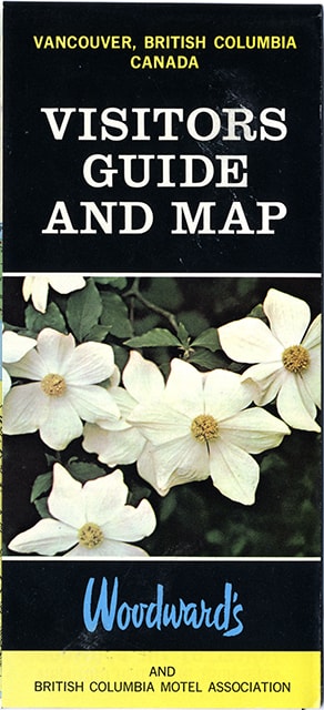
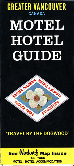
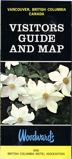
- Description
- map brochure; cover on one side reads "VANCOUVER, BRITISH COLUMBIA / CANADA / VISITORS / GUIDE / AND MAP" and the other side reads: "GREATER VANCOUVER / CANADA / MOTEL / HOTEL / GUIDE / TRAVEL BY THE DOGOOD'" and includes the logo for "British Columbia / Motels & Resorts / Trailer Parks / Association" with dogwood in centre. One side of fold-out includes map titled "Guide Map of Greater Vancouver / Woodwards" and includes inset map of Downtown Vancouver and Stanley Park and inset map of Lower Mainland and Fraser Valley Vancouver and Vicinity along with a list of Greater Vanouver Area Motels and Hotels. The other side of the fold-out includes colour adds for tourist sites and amenities in Greater Vancouver including Capilano Suspension bridge; Heritage Village, Burnaby, B.C.; MacMillan Planetarium; Bloedel Conservatory; Grouse Mountain; Gastown; The Ship of the Seven Seas restaurant and Woodwards stores and shopping centres. Map was published in the public interest by Woodward's (Lower Mainland) department stores; B.C. Motels and Resorts Association Branch "C" whose members appear on the map inside.
- Category
- 08. Communication Artifacts
- Classification
- Documentary Artifacts - - Graphic Documents
- Object Term
- Cartograph, Map
- Measurements
- 45.5 x 70 cm folded to 22.5 x 10 cm
- Country Made
- Canada
- Geographic Access
- Vancouver
Images