
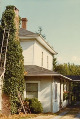
Burnett home
https://search.heritageburnaby.ca/link/archivedescription37371
- Repository
- City of Burnaby Archives
- Date
- 1974
- Collection/Fonds
- Burnaby Historical Society fonds
- Description Level
- Item
- Physical Description
- 1 photograph : col. ; 9 x 12.8 cm
- Scope and Content
- Photograph of the home of Mr. Burnett (old street number 6561 Canada Way).
- Repository
- City of Burnaby Archives
- Date
- 1974
- Collection/Fonds
- Burnaby Historical Society fonds
- Subseries
- Photographs subseries
- Physical Description
- 1 photograph : col. ; 9 x 12.8 cm
- Description Level
- Item
- Record No.
- 365-002
- Access Restriction
- No restrictions
- Reproduction Restriction
- Reproduce for fair dealing purposes only
- Accession Number
- BHS2007-04
- Scope and Content
- Photograph of the home of Mr. Burnett (old street number 6561 Canada Way).
- Subjects
- Buildings - Residential - Houses
- Media Type
- Photograph
- Notes
- Title based on caption
- Geographic Access
- Canada Way
- Planning Study Area
- Lakeview-Mayfield Area
Images

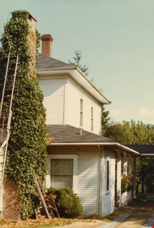
Detail of the Burnett home
https://search.heritageburnaby.ca/link/archivedescription37370
- Repository
- City of Burnaby Archives
- Date
- 1974
- Collection/Fonds
- Burnaby Historical Society fonds
- Description Level
- Item
- Physical Description
- 1 photograph : col. ; 9 x 12.8 cm
- Scope and Content
- Photograph of a house identified by a note on the back of the photograph as the home of Mr. Burnett (old street number 6561 Canada Way). Two ladders are visible resting against the ivy-covered chimney but only a partial view of the home is pictured.
- Repository
- City of Burnaby Archives
- Date
- 1974
- Collection/Fonds
- Burnaby Historical Society fonds
- Subseries
- Photographs subseries
- Physical Description
- 1 photograph : col. ; 9 x 12.8 cm
- Description Level
- Item
- Record No.
- 365-001
- Access Restriction
- No restrictions
- Reproduction Restriction
- Reproduce for fair dealing purposes only
- Accession Number
- BHS2007-04
- Scope and Content
- Photograph of a house identified by a note on the back of the photograph as the home of Mr. Burnett (old street number 6561 Canada Way). Two ladders are visible resting against the ivy-covered chimney but only a partial view of the home is pictured.
- Media Type
- Photograph
- Notes
- Title based on caption
- Geographic Access
- Canada Way
- Planning Study Area
- Lakeview-Mayfield Area
Images
![Douglas Road, Burnaby, [1908] thumbnail](/media/hpo/_Data/_Archives_Images/_Unrestricted/371/449-009.jpg?width=280)
Douglas Road, Burnaby
https://search.heritageburnaby.ca/link/archivedescription38514
- Repository
- City of Burnaby Archives
- Date
- [1908]
- Collection/Fonds
- Burnaby Historical Society fonds
- Description Level
- Item
- Physical Description
- 1 photograph : sepia postcard ; 8.8 x 14 cm
- Scope and Content
- Photographic postcard taken looking northwest along Douglas Road (now Canada Way) near Stanley Street. Two unidentified people are standing next to a wooden fence running alongside the road (above Lubbock's Creek) and a number of houses (including the Sprott house) are visible in the background. To…
- Repository
- City of Burnaby Archives
- Date
- [1908]
- Collection/Fonds
- Burnaby Historical Society fonds
- Subseries
- Photographs subseries
- Physical Description
- 1 photograph : sepia postcard ; 8.8 x 14 cm
- Description Level
- Item
- Record No.
- 449-009
- Access Restriction
- No restrictions
- Reproduction Restriction
- No known restrictions
- Accession Number
- BHS2007-04
- Scope and Content
- Photographic postcard taken looking northwest along Douglas Road (now Canada Way) near Stanley Street. Two unidentified people are standing next to a wooden fence running alongside the road (above Lubbock's Creek) and a number of houses (including the Sprott house) are visible in the background. To the right is Burnaby Lake. Stamped at the top of the postcard is "Douglas Road, Burnaby / New Westminster BC."
- Subjects
- Geographic Features - Lakes and Ponds
- Documentary Artifacts - Postcards
- Geographic Features - Roads
- Media Type
- Photograph
- Geographic Access
- Douglas Road
- Stanley Street
- Canada Way
- Deer Lake
- Historic Neighbourhood
- Burnaby Lake (Historic Neighbourhood)
- Planning Study Area
- Lakeview-Mayfield Area
Images
![Douglas Road, Burnaby, [1908] thumbnail](/media/hpo/_Data/_Archives_Images/_Unrestricted/371/449-009.jpg)
![Vehicle accident on Canada Way, [2000] thumbnail](/media/hpo/_Data/_Archives_Images/_Unrestricted/535/535-2687.jpg?width=280)
Vehicle accident on Canada Way
https://search.heritageburnaby.ca/link/archivedescription97290
- Repository
- City of Burnaby Archives
- Date
- [2000]
- Collection/Fonds
- Burnaby NewsLeader photograph collection
- Description Level
- Item
- Physical Description
- 1 photograph (tiff) : col.
- Scope and Content
- Photograph of an unidentified Burnaby RCMP officer standing on the road by a van that collided with a hydro pole at Canada Way and Morley Street. The pole is under the white van, which also dragged down lights and live wires.
- Repository
- City of Burnaby Archives
- Date
- [2000]
- Collection/Fonds
- Burnaby NewsLeader photograph collection
- Physical Description
- 1 photograph (tiff) : col.
- Description Level
- Item
- Record No.
- 535-2687
- Access Restriction
- No restrictions
- Reproduction Restriction
- Reproduce for fair dealing purposes only
- Accession Number
- 2018-12
- Scope and Content
- Photograph of an unidentified Burnaby RCMP officer standing on the road by a van that collided with a hydro pole at Canada Way and Morley Street. The pole is under the white van, which also dragged down lights and live wires.
- Media Type
- Photograph
- Photographer
- Bartel, Mario
- Notes
- Title based on caption
- Collected by editorial for use in a September 2000 issue of the Burnaby NewsLeader
- Caption from metadata: "A Burnaby RCMP officer keeps a safe distance after a van collided with a hydro pole on Canada Way at Morley, dragging down a couple of light standards and live wires. The road was closed, and power to the surrounding area was out for a number of hours."
- Geographic Access
- Canada Way
- Morley Street
- Historic Neighbourhood
- Burnaby Lake (Historic Neighbourhood)
- Planning Study Area
- Lakeview-Mayfield Area
Images
![Vehicle accident on Canada Way, [2000] thumbnail](/media/hpo/_Data/_Archives_Images/_Unrestricted/535/535-2687.jpg)