Narrow Results By
Person / Organization
- Bearn, William "Bill" 1
- Bearn, William "Bud" 1
- Borstal School 2
- British Columbia Electric Railway Company 1
- British Columbia Hydro and Power Authority 1
- Burnaby Market 1
- Burnaby South High School 1
- Burnaby Village Museum 1
- Canadian National Railway 1
- Chinese Market Gardens 3
- Chow, Josephine 1
- Christianson, Audrey Frances May Bearn 1
![Michael J. Fox at golf fundraiser, [2001] thumbnail](/media/hpo/_Data/_Archives_Images/_Unrestricted/535/535-2485-1.jpg?width=280)
Michael J. Fox at golf fundraiser
https://search.heritageburnaby.ca/link/archivedescription96930
- Repository
- City of Burnaby Archives
- Date
- [2001]
- Collection/Fonds
- Burnaby NewsLeader photograph collection
- Description Level
- File
- Physical Description
- 2 photographs (tiff) : col.
- Scope and Content
- File contains photographs of Michael J. Fox at a fundraising event for the Michael J. Fox Theatre at Burnaby South Secondary School at Riverway Golf Club. Photographs depict Fox greeting unidentified golfers and on a golf cart with unidentified members of his family.
- Repository
- City of Burnaby Archives
- Date
- [2001]
- Collection/Fonds
- Burnaby NewsLeader photograph collection
- Physical Description
- 2 photographs (tiff) : col.
- Description Level
- File
- Record No.
- 535-2485
- Access Restriction
- No restrictions
- Reproduction Restriction
- No restrictions
- Accession Number
- 2018-12
- Scope and Content
- File contains photographs of Michael J. Fox at a fundraising event for the Michael J. Fox Theatre at Burnaby South Secondary School at Riverway Golf Club. Photographs depict Fox greeting unidentified golfers and on a golf cart with unidentified members of his family.
- Media Type
- Photograph
- Photographer
- Bartel, Mario
- Notes
- Title based on caption
- Collected by editorial for use in a June 2001 issue of the Burnaby NewsLeader
- Caption from metadata for 535-2485-1: "Burnaby's Michael J. Fox greets golfers at Riverway Golf Club, as they prepare to head out for the start of a tournament to raise money for the Michael J. Fox Theatre at Burnaby South Secondary School. Fox, who now lives in New York City, also announced he and his wife, actress Tracy Pollan, are expecting their fourth child."
- Caption from metadata for 535-2485-2: "Burnaby's Michael J. Fox and his family prepare to head out to the course at Riverway Golf Club, for the start of a tournament to raise money for the Michael J. Fox Theatre."
- Geographic Access
- Bill Fox Way
- Street Address
- 9001 Bill Fox Way
- Historic Neighbourhood
- Fraser Arm (Historic Neighbourhood)
- Planning Study Area
- Big Bend Area
Images
![Michael J. Fox at golf fundraiser, [2001] thumbnail](/media/hpo/_Data/_Archives_Images/_Unrestricted/535/535-2485-1.jpg)
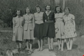
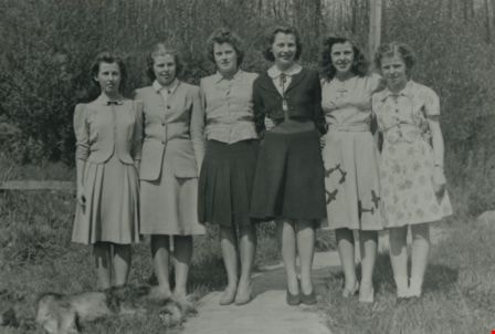
Morris daughters
https://search.heritageburnaby.ca/link/archivedescription36487
- Repository
- City of Burnaby Archives
- Date
- May 1942
- Collection/Fonds
- Burnaby Historical Society fonds
- Description Level
- Item
- Physical Description
- 1 photograph : b&w ; 12.5 x 8.5 cm print
- Scope and Content
- Photograph of the Morris daughters standing on a pathway at Marine Drive, in a row from eldest to youngest: Margaret Janet (eldest), Laura Elizabeth (Betty), Dorothy Rhoda Adelaide, Jessie Ellen, Gertrude Kathleen, to Mureil (youngest). Their dog Nemo is lying at their feet.
- Repository
- City of Burnaby Archives
- Date
- May 1942
- Collection/Fonds
- Burnaby Historical Society fonds
- Subseries
- Morris family subseries
- Physical Description
- 1 photograph : b&w ; 12.5 x 8.5 cm print
- Description Level
- Item
- Record No.
- 278-003
- Access Restriction
- No restrictions
- Reproduction Restriction
- No known restrictions
- Accession Number
- BHS1992-08
- Scope and Content
- Photograph of the Morris daughters standing on a pathway at Marine Drive, in a row from eldest to youngest: Margaret Janet (eldest), Laura Elizabeth (Betty), Dorothy Rhoda Adelaide, Jessie Ellen, Gertrude Kathleen, to Mureil (youngest). Their dog Nemo is lying at their feet.
- Subjects
- Animals - Dogs
- Names
- Sheldon, Margaret Janet Morris
- Morris, Laura Elizabeth "Betty"
- Morris, Dorothy Rhoda Adelaide
- Morris, Jessie Ellen
- Morris, Gertrude Kathleen
- Morris, Muriel
- Media Type
- Photograph
- Notes
- Title based on contents of photograph
- Geographic Access
- Marine Drive
- Historic Neighbourhood
- Fraser Arm (Historic Neighbourhood)
- Planning Study Area
- Big Bend Area
- Sussex-Nelson Area
Images
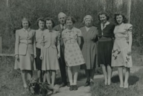
Morris family
https://search.heritageburnaby.ca/link/archivedescription36486
- Repository
- City of Burnaby Archives
- Date
- May 1942
- Collection/Fonds
- Burnaby Historical Society fonds
- Description Level
- Item
- Physical Description
- 1 photograph : b&w ; 8.5 x 12.5 cm print
- Scope and Content
- Photograph of the Morris family; Second eldest Laura Elizabeth (Betty), third eldest Dorothy Rhoda Adelaide, eldest Margaret Janet, and father Dr. Morris, along with youngest Muriel, mother Laura Maude Weegar Morris, third youngest Jessie Ellen, and second youngest Gertrude Kathleen standing beside…
- Repository
- City of Burnaby Archives
- Date
- May 1942
- Collection/Fonds
- Burnaby Historical Society fonds
- Subseries
- Morris family subseries
- Physical Description
- 1 photograph : b&w ; 8.5 x 12.5 cm print
- Description Level
- Item
- Record No.
- 278-002
- Access Restriction
- No restrictions
- Reproduction Restriction
- No known restrictions
- Accession Number
- BHS1992-08
- Scope and Content
- Photograph of the Morris family; Second eldest Laura Elizabeth (Betty), third eldest Dorothy Rhoda Adelaide, eldest Margaret Janet, and father Dr. Morris, along with youngest Muriel, mother Laura Maude Weegar Morris, third youngest Jessie Ellen, and second youngest Gertrude Kathleen standing beside a pathway at Marine Drive. Their dog Nemo is lying at Laura Elizabeth's feet. (Nemo was part police dog).
- Subjects
- Animals - Dogs
- Names
- Morris, Laura Elizabeth "Betty"
- Morris, Dorothy Rhoda Adelaide
- Sheldon, Margaret Janet Morris
- Morris, Dr. Wesley Gardier
- Morris, Muriel
- Morris, Laura Maude Weegar
- Morris, Jessie Ellen
- Morris, Gertrude Kathleen
- Media Type
- Photograph
- Notes
- Title based on contents of photograph
- Geographic Access
- Marine Drive
- Historic Neighbourhood
- Fraser Arm (Historic Neighbourhood)
- Planning Study Area
- Big Bend Area
- Sussex-Nelson Area
Images


Municipality of Burnaby- Volume XV and Volume XVIII
https://search.heritageburnaby.ca/link/museumdescription8686
- Repository
- Burnaby Village Museum
- Date
- May 1927
- Collection/Fonds
- Burnaby Village Museum Map collection
- Description Level
- File
- Physical Description
- 4 plans on 4 sheets : col. lithographic prints ; 63.5 x 53.5 cm folded to 53 x 31.5 cm
- Scope and Content
- File consists of four pages of plans removed from a bound book containing a series of fire insurance plans of the Municipality of Burnaby. Plan "1520" is part of "GREATER VANCOUVER B.C. / VOLUME XV / Municipality of Burnaby / May 1927" and covers District Lots: 121 and 187. Plann "1521" is part of …
- Repository
- Burnaby Village Museum
- Collection/Fonds
- Burnaby Village Museum Map collection
- Description Level
- File
- Physical Description
- 4 plans on 4 sheets : col. lithographic prints ; 63.5 x 53.5 cm folded to 53 x 31.5 cm
- Material Details
- Scale [1:600] and [1:1200]
- Scope and Content
- File consists of four pages of plans removed from a bound book containing a series of fire insurance plans of the Municipality of Burnaby. Plan "1520" is part of "GREATER VANCOUVER B.C. / VOLUME XV / Municipality of Burnaby / May 1927" and covers District Lots: 121 and 187. Plann "1521" is part of "GREATER VANCOUVER B.C. / VOLUME XV / Municipality of Burnaby / May 1927" and covers District Lots: 121 and 187. Key plan "H" reads: "GREATER VANCOUVER B.C. / VOLUME XVIII / Surveyed _ May 1927 / MUNICIPALITY OF / BURNABY" and covers plans: 1813 to 1822; 1824 to 1832; 1839; 1840; 1853 to 1865 and District Lots: 28; 30; 53; 90 to 93; 95 to 97; 155a; 155b; 155c; 159; 160; 171 to 173. Plan "1801" is part of "GREATER VANCOUVER B.C. / VOLUME XVIII / Municipality of Burnaby / May 1927" and covers District Lot 153.
- Responsibility
- British Columbia Underwriters' Association
- Accession Code
- HV972.111.8
- Access Restriction
- No restrictions
- Reproduction Restriction
- May be restricted by third party rights
- Date
- May 1927
- Media Type
- Cartographic Material
- Historic Neighbourhood
- Fraser Arm (Historic Neighbourhood)
- Vancouver Heights (Historic Neighbourhood)
- East Burnaby (Historic Neighbourhood)
- Edmonds (Historic Neighbourhood)
- Planning Study Area
- Marlborough Area
- Kingsway-Beresford Area
- Windsor Area
- Big Bend Area
- Clinton-Glenwood Area
- Burnaby Heights Area
- Edmonds Area
- Stride Avenue Area
- Scan Resolution
- 400
- Scan Date
- 2021-11-18
- Notes
- Title based on content of plans
- See also BV987.1.70d for revised versions of plans
- Scale is measured 1 inch = 500 feet
Zoomable Images


Municipality of Burnaby - Volume XVIII and Volume XIX
https://search.heritageburnaby.ca/link/museumdescription8683
- Repository
- Burnaby Village Museum
- Date
- May 1927
- Collection/Fonds
- Burnaby Village Museum Map collection
- Description Level
- File
- Physical Description
- 2 plans on 2 sheets : col. lithographic prints ; 63.5 x 53.5 cm folded to 53 x 31.5 cm
- Scope and Content
- File consists of two pages of plans removed from a bound book containing a series of fire insurance plans of the Municipality of Burnaby. Plan "1832" is from "GREATER VANCOUVER B.C. / VOLUME XVIII / Municipality of Burnaby / May, 1927" and covers District Lots: 98 and 28. Plan "K" is part of a key …
- Repository
- Burnaby Village Museum
- Collection/Fonds
- Burnaby Village Museum Map collection
- Description Level
- File
- Physical Description
- 2 plans on 2 sheets : col. lithographic prints ; 63.5 x 53.5 cm folded to 53 x 31.5 cm
- Material Details
- Scale [1:1200] to [1:6000]
- Scope and Content
- File consists of two pages of plans removed from a bound book containing a series of fire insurance plans of the Municipality of Burnaby. Plan "1832" is from "GREATER VANCOUVER B.C. / VOLUME XVIII / Municipality of Burnaby / May, 1927" and covers District Lots: 98 and 28. Plan "K" is part of a key plan "GREATER VANCOUVER B.C. / Surveyed VOLUME XIX May 1927 / MUNICIPALITY OF / BURNABY / PLAN DEPT. British Columbia Ins. Underwriters Association / FIRE BRANCH / KEY PLAN", "Scale 500 FT = 1 INCH / FOR REPORT SEE VOL. XV" covering plans: 1901 to 1914 and District Lots: 161; 164 to 167; 155c; 155; 172 and 173.
- Responsibility
- British Columbia Underwriters' Association
- Accession Code
- HV972.111.5
- Access Restriction
- No restrictions
- Reproduction Restriction
- May be restricted by third party rights
- Date
- May 1927
- Media Type
- Cartographic Material
- Historic Neighbourhood
- East Burnaby (Historic Neighbourhood)
- Central Park (Historic Neighbourhood)
- Fraser Arm (Historic Neighbourhood)
- Alta Vista (Historic Neighbourhood)
- Planning Study Area
- Windsor Area
- Marlborough Area
- Second Street Area
- Big Bend Area
- Sussex-Nelson Area
- Scan Resolution
- 400
- Scan Date
- 2021-11-18
- Notes
- Title based on content of plans
- See also BV987.1.70d for revised versions of plans
- Scale is measured 1 inch = 500 feet
Zoomable Images


Municipality of Burnaby - Volume XV, Volume XVI, Volume XVII, Volume XVIII
https://search.heritageburnaby.ca/link/museumdescription8685
- Repository
- Burnaby Village Museum
- Date
- May 1927
- Collection/Fonds
- Burnaby Village Museum Map collection
- Description Level
- File
- Physical Description
- 4 plans on 4 sheets : col. lithographic prints ; 63.5 x 53.5 cm folded to 53 x 31.5 cm
- Scope and Content
- File consists of four pages of plans removed from a bound book containing a series of fire insurance plans of the Municipality of Burnaby. Plan "1531" is part of "GREATER VANCOUVER B.C. / VOLUME XV / Municipality of Burnaby / May 1927" and covers District Lots: 116 and 117. Key Plan "C" is part of …
- Repository
- Burnaby Village Museum
- Collection/Fonds
- Burnaby Village Museum Map collection
- Description Level
- File
- Physical Description
- 4 plans on 4 sheets : col. lithographic prints ; 63.5 x 53.5 cm folded to 53 x 31.5 cm
- Material Details
- Scale [1:600] and [1:1200]
- Scope and Content
- File consists of four pages of plans removed from a bound book containing a series of fire insurance plans of the Municipality of Burnaby. Plan "1531" is part of "GREATER VANCOUVER B.C. / VOLUME XV / Municipality of Burnaby / May 1927" and covers District Lots: 116 and 117. Key Plan "C" is part of "GREATER VANCOUVER B.C. / VOLUME XVI / Municipality of Burnaby / May 1927" and covers plans 1623 to 1651 and District Lots: 1 and 2; 4; 6; 8; 10 to 14; 25; 27; 40; 56 to 58; 88 and 89. Plan "1738" is part of "GREATER VANCOUVER B.C. / VOLUME XVII / Municipality of Burnaby / May 1927" and covers District Lots: 34 and 35. Key plan "G" is part of "GREATER VANCOUVER B.C. / VOLUME XVIII / Municipality of Burnaby / May 1927" and covers plans: 1801 to 1813; 1823; 1824; 1833 to 1838; 1841 to 1853 and District Lots: 32; 93; 94; 97 to 99; 149; 150; 152; 155 to 159; 161 to 164.
- Responsibility
- British Columbia Underwriters' Association
- Accession Code
- HV972.111.7
- Access Restriction
- No restrictions
- Reproduction Restriction
- May be restricted by third party rights
- Date
- May 1927
- Media Type
- Cartographic Material
- Historic Neighbourhood
- Central Park (Historic Neighbourhood)
- Fraser Arm (Historic Neighbourhood)
- Alta Vista (Historic Neighbourhood)
- Broadview (Historic Neighbourhood)
- Vancouver Heights (Historic Neighbourhood)
- Burquitlam (Historic Neighbourhood)
- East Burnaby (Historic Neighbourhood)
- Edmonds (Historic Neighbourhood)
- Lozells (Historic Neighbourhood)
- Planning Study Area
- Clinton-Glenwood Area
- Marlborough Area
- Maywood Area
- Windsor Area
- Big Bend Area
- Garden Village Area
- Willingdon Heights Area
- West Central Valley Area
- Cariboo-Armstrong Area
- Lyndhurst Area
- Cameron Area
- Lake City Area
- Edmonds Area
- Second Street Area
- Sperling-Broadway Area
- Lakeview-Mayfield Area
- Scan Resolution
- 400
- Scan Date
- 2021-11-18
- Notes
- Title based on content of plans
- See also BV987.1.70d for revised versions of plans
- Scale is measured 1 inch = 500 feet
Zoomable Images

Municipality of Burnaby - Volume XV, Volume XVI, Volume XVII, Volume XVIII, May 1927
Zoom into Image

New Haven Borstal (Barn)
https://search.heritageburnaby.ca/link/archivedescription93662
- Repository
- City of Burnaby Archives
- Date
- January 15, 1978
- Collection/Fonds
- Burnaby Public Library Contemporary Visual Archive Project
- Description Level
- Item
- Physical Description
- 1 photograph : b&w ; 12.5 x 17.5 cm
- Scope and Content
- Photograph of the exterior of the barn at the New Haven Borstal Institute, located at 4250 Marine Drive. The photograph is taken facing northeast. New Haven operated out of the Glen-Lyon Estate, which the provincial government purchased in 1939.
- Repository
- City of Burnaby Archives
- Date
- January 15, 1978
- Collection/Fonds
- Burnaby Public Library Contemporary Visual Archive Project
- Physical Description
- 1 photograph : b&w ; 12.5 x 17.5 cm
- Description Level
- Item
- Record No.
- 556-619
- Access Restriction
- No restrictions
- Reproduction Restriction
- Reproduce for fair dealing purposes only
- Accession Number
- 2017-57
- Scope and Content
- Photograph of the exterior of the barn at the New Haven Borstal Institute, located at 4250 Marine Drive. The photograph is taken facing northeast. New Haven operated out of the Glen-Lyon Estate, which the provincial government purchased in 1939.
- Subjects
- Buildings - Public - Detention Facilities
- Buildings - Schools
- Government - Provincial Government
- Buildings - Heritage
- Media Type
- Photograph
- Photographer
- Hauger, C.
- Notes
- Title taken from project information form
- Accompanied by a project information form and 1 photograph (b&w negative ; 9.5 x 12.5 cm)
- BPL no. 68
- Geographic Access
- Marine Drive
- Street Address
- 4250 Marine Drive
- Historic Neighbourhood
- Fraser Arm (Historic Neighbourhood)
- Planning Study Area
- Big Bend Area
Images


New Haven Borstal Main Building
https://search.heritageburnaby.ca/link/archivedescription93665
- Repository
- City of Burnaby Archives
- Date
- January 15, 1978
- Collection/Fonds
- Burnaby Public Library Contemporary Visual Archive Project
- Description Level
- Item
- Physical Description
- 1 photograph : b&w ; 12.5 x 17.5 cm
- Scope and Content
- Photograph of the side exterior of the main building of the New Haven Borstal Institute, located at 4250 Marine Drive. The main building is the old mansion of the Glen-Lyon estate, which the provincial government purchased in 1939. The photograph is taken from the sidewalk, facing northeast.
- Repository
- City of Burnaby Archives
- Date
- January 15, 1978
- Collection/Fonds
- Burnaby Public Library Contemporary Visual Archive Project
- Physical Description
- 1 photograph : b&w ; 12.5 x 17.5 cm
- Description Level
- Item
- Record No.
- 556-622
- Access Restriction
- No restrictions
- Reproduction Restriction
- Reproduce for fair dealing purposes only
- Accession Number
- 2017-57
- Scope and Content
- Photograph of the side exterior of the main building of the New Haven Borstal Institute, located at 4250 Marine Drive. The main building is the old mansion of the Glen-Lyon estate, which the provincial government purchased in 1939. The photograph is taken from the sidewalk, facing northeast.
- Subjects
- Buildings - Public - Detention Facilities
- Buildings - Schools
- Buildings - Heritage
- Government - Provincial Government
- Media Type
- Photograph
- Photographer
- Roberts, S.
- Notes
- Title taken from project information form
- Accompanied by a project information form and 1 photograph (b&w negative ; 9.5 x 12.5 cm)
- BPL no. 71
- Geographic Access
- Marine Drive
- Street Address
- 4250 Marine Drive
- Historic Neighbourhood
- Fraser Arm (Historic Neighbourhood)
- Planning Study Area
- Big Bend Area
Images


New Haven Borstal Main Building
https://search.heritageburnaby.ca/link/archivedescription93667
- Repository
- City of Burnaby Archives
- Date
- January 15, 1978
- Collection/Fonds
- Burnaby Public Library Contemporary Visual Archive Project
- Description Level
- Item
- Physical Description
- 1 photograph : b&w ; 12.5 x 17.5 cm
- Scope and Content
- Photograph of the side exterior of the main building of the New Haven Borstal Institute, located at 4250 Marine Drive. The main building is the old mansion of the Glen-Lyon estate, which the provincial government purchased in 1939. The photograph is taken from the sidewalk, facing northwest.
- Repository
- City of Burnaby Archives
- Date
- January 15, 1978
- Collection/Fonds
- Burnaby Public Library Contemporary Visual Archive Project
- Physical Description
- 1 photograph : b&w ; 12.5 x 17.5 cm
- Description Level
- Item
- Record No.
- 556-624
- Access Restriction
- No restrictions
- Reproduction Restriction
- Reproduce for fair dealing purposes only
- Accession Number
- 2017-57
- Scope and Content
- Photograph of the side exterior of the main building of the New Haven Borstal Institute, located at 4250 Marine Drive. The main building is the old mansion of the Glen-Lyon estate, which the provincial government purchased in 1939. The photograph is taken from the sidewalk, facing northwest.
- Subjects
- Buildings - Public - Detention Facilities
- Buildings - Schools
- Buildings - Heritage
- Government - Provincial Government
- Media Type
- Photograph
- Photographer
- Hauger, C.
- Notes
- Title taken from project information form
- Accompanied by a project information form and 1 photograph (b&w negative ; 9.5 x 12.5 cm)
- BPL no. 73
- Geographic Access
- Marine Drive
- Street Address
- 4250 Marine Drive
- Historic Neighbourhood
- Fraser Arm (Historic Neighbourhood)
- Planning Study Area
- Big Bend Area
Images


New Haven Borstal Workshop
https://search.heritageburnaby.ca/link/archivedescription93666
- Repository
- City of Burnaby Archives
- Date
- January 15, 1978
- Collection/Fonds
- Burnaby Public Library Contemporary Visual Archive Project
- Description Level
- Item
- Physical Description
- 1 photograph : b&w ; 12.5 x 17.5 cm
- Scope and Content
- Photograph of the exterior of the workshop at the New Haven Borstal Institute, located across the street from the main building at 4250 Marine Drive. The photograph is taken from across the lawn, facing northeast. Cars are parked outside the workshop and the front of the main building, previously t…
- Repository
- City of Burnaby Archives
- Date
- January 15, 1978
- Collection/Fonds
- Burnaby Public Library Contemporary Visual Archive Project
- Physical Description
- 1 photograph : b&w ; 12.5 x 17.5 cm
- Description Level
- Item
- Record No.
- 556-623
- Access Restriction
- No restrictions
- Reproduction Restriction
- Reproduce for fair dealing purposes only
- Accession Number
- 2017-57
- Scope and Content
- Photograph of the exterior of the workshop at the New Haven Borstal Institute, located across the street from the main building at 4250 Marine Drive. The photograph is taken from across the lawn, facing northeast. Cars are parked outside the workshop and the front of the main building, previously the Glen-Lyon estate mansion, is visible in the background.
- Subjects
- Buildings - Public - Detention Facilities
- Buildings - Schools
- Buildings - Heritage
- Government - Provincial Government
- Media Type
- Photograph
- Photographer
- Roberts, S.
- Notes
- Title taken from project information form
- Accompanied by a project information form and 1 photograph (b&w negative ; 9.5 x 12.5 cm)
- BPL no. 72
- Geographic Access
- Marine Drive
- Street Address
- 4250 Marine Drive
- Historic Neighbourhood
- Fraser Arm (Historic Neighbourhood)
- Planning Study Area
- Big Bend Area
Images

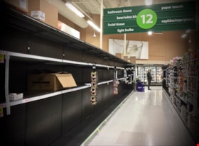
No More Toilet Paper
https://search.heritageburnaby.ca/link/archivedescription95092
- Repository
- City of Burnaby Archives
- Date
- March 14, 2020
- Collection/Fonds
- Burnaby Photographic Society fonds
- Description Level
- Item
- Physical Description
- 1 photograph (tiff)
- Scope and Content
- Photograph of bare shelves in the bathroom tissue aisle of Save-On-Foods at the Market Crossing Shopping Centre in Burnaby.
- Repository
- City of Burnaby Archives
- Date
- March 14, 2020
- Collection/Fonds
- Burnaby Photographic Society fonds
- Physical Description
- 1 photograph (tiff)
- Description Level
- Item
- Record No.
- 623-011
- Access Restriction
- No restrictions
- Reproduction Restriction
- Reproduce for fair dealing purposes only
- Accession Number
- 2020-10
- Scope and Content
- Photograph of bare shelves in the bathroom tissue aisle of Save-On-Foods at the Market Crossing Shopping Centre in Burnaby.
- Media Type
- Photograph
- Photographer
- Asbia, Cher
- Notes
- Transcribed title
- Geographic Access
- Market Crossing
- Marine Way
- Historic Neighbourhood
- Fraser Arm (Historic Neighbourhood)
- Planning Study Area
- Big Bend Area
Images

Norma Rypdal
https://search.heritageburnaby.ca/link/archivedescription36847
- Repository
- City of Burnaby Archives
- Date
- 1930 (date of original), copied 1992
- Collection/Fonds
- Burnaby Historical Society fonds
- Description Level
- Item
- Physical Description
- 1 photograph : b&w ; 8.7 x 11.4 cm print
- Scope and Content
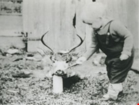
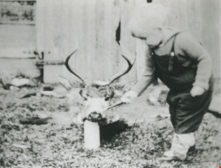
- Photograph of Norma Rypdal, at two years old, with a deer shot on the flats near her home.
- Repository
- City of Burnaby Archives
- Date
- 1930 (date of original), copied 1992
- Collection/Fonds
- Burnaby Historical Society fonds
- Subseries
- Burnaby Centennial Anthology subseries
- Physical Description
- 1 photograph : b&w ; 8.7 x 11.4 cm print
- Description Level
- Item
- Record No.
- 315-305
- Access Restriction
- No restrictions
- Reproduction Restriction
- No known restrictions
- Accession Number
- BHS1994-04
- Scope and Content
- Photograph of Norma Rypdal, at two years old, with a deer shot on the flats near her home.
- Names
- Perry, Norma Rypdal
- Media Type
- Photograph
- Notes
- Title based on contents of photograph
- Historic Neighbourhood
- Fraser Arm (Historic Neighbourhood)
- Planning Study Area
- Big Bend Area
Images
![North Arm Dairy, [1905] thumbnail](/media/hpo/_Data/_Archives_Images/_Unrestricted/251/275-005.jpg?width=280)
North Arm Dairy
https://search.heritageburnaby.ca/link/archivedescription36473
- Repository
- City of Burnaby Archives
- Date
- [1905]
- Collection/Fonds
- Burnaby Historical Society fonds
- Description Level
- Item
- Physical Description
- 1 photograph : b&w ; 8.5 x 12.5 cm print
- Scope and Content
- Photograph of the North Arm Dairy, the Thrussell farm and family business. Half a dozen cows are walking towards the barn as the children mingle around them. The large barn is in the center, and the North Arm Dairy wagon is visible in the background.
- Repository
- City of Burnaby Archives
- Date
- [1905]
- Collection/Fonds
- Burnaby Historical Society fonds
- Subseries
- Thrussell family subseries
- Physical Description
- 1 photograph : b&w ; 8.5 x 12.5 cm print
- Description Level
- Item
- Record No.
- 275-005
- Access Restriction
- No restrictions
- Reproduction Restriction
- No known restrictions
- Accession Number
- BHS1992-05
- Scope and Content
- Photograph of the North Arm Dairy, the Thrussell farm and family business. Half a dozen cows are walking towards the barn as the children mingle around them. The large barn is in the center, and the North Arm Dairy wagon is visible in the background.
- Subjects
- Agriculture - Farms
- Animals - Cows
- Names
- North Arm Dairy
- Media Type
- Photograph
- Notes
- Title based on contents of photograph
- Geographic Access
- Marine Drive
- Nelson Avenue
- Historic Neighbourhood
- Fraser Arm (Historic Neighbourhood)
- Planning Study Area
- Big Bend Area
Images
![North Arm Dairy, [1905] thumbnail](/media/hpo/_Data/_Archives_Images/_Unrestricted/251/275-005.jpg)
![North Arm Dairy, [1905] thumbnail](/media/hpo/_Data/_Archives_Images/_Unrestricted/251/275-006.jpg?width=280)
North Arm Dairy
https://search.heritageburnaby.ca/link/archivedescription36474
- Repository
- City of Burnaby Archives
- Date
- [1905]
- Collection/Fonds
- Burnaby Historical Society fonds
- Description Level
- Item
- Physical Description
- 1 photograph : b&w ; 8.5 x 12.5 cm print
- Scope and Content
- Photograph of the North Arm Dairy, the Thrussell farm and family business. The family is standing in front of the garage that houses the North Arm Diary wagon. The younger Frederick is standing with his arm across his brow, blocking the sun. His two sisters Ethel and Mary Anne are beside him. Eva i…
- Repository
- City of Burnaby Archives
- Date
- [1905]
- Collection/Fonds
- Burnaby Historical Society fonds
- Subseries
- Thrussell family subseries
- Physical Description
- 1 photograph : b&w ; 8.5 x 12.5 cm print
- Description Level
- Item
- Record No.
- 275-006
- Access Restriction
- No restrictions
- Reproduction Restriction
- No known restrictions
- Accession Number
- BHS1992-05
- Scope and Content
- Photograph of the North Arm Dairy, the Thrussell farm and family business. The family is standing in front of the garage that houses the North Arm Diary wagon. The younger Frederick is standing with his arm across his brow, blocking the sun. His two sisters Ethel and Mary Anne are beside him. Eva is standing beside her mother Harriett, who has baby Edith in her arms. The elder Frederick is standing front and center. Another man stands off to the right. In the distance, half a dozen cows are walking towards the barn.
- Subjects
- Agriculture - Farms
- Animals - Cows
- Names
- North Arm Dairy
- Thrussell, Frederick T.
- Thrussell, Ethel
- Welsh, Mary Anne "Annie" Thrussell Phillips
- Thrussell, Eva
- Thrussell, Harriett Fenwick
- Cleghorn, Edith Thrussell
- Thrussell, Fredrick (1869-1909)
- Media Type
- Photograph
- Notes
- Title based on contents of photograph
- Geographic Access
- Marine Drive
- Nelson Avenue
- Historic Neighbourhood
- Fraser Arm (Historic Neighbourhood)
- Planning Study Area
- Big Bend Area
Images
![North Arm Dairy, [1905] thumbnail](/media/hpo/_Data/_Archives_Images/_Unrestricted/251/275-006.jpg)
![North Arm Dairy, [1907] thumbnail](/media/hpo/_Data/_Archives_Images/_Unrestricted/251/275-007.jpg?width=280)
North Arm Dairy
https://search.heritageburnaby.ca/link/archivedescription36475
- Repository
- City of Burnaby Archives
- Date
- [1907]
- Collection/Fonds
- Burnaby Historical Society fonds
- Description Level
- Item
- Physical Description
- 1 photograph : b&w ; 8.5 x 12.5 cm print
- Scope and Content
- Photograph of the North Arm Dairy, the Thrussell farm and family business. A young child is sitting on one of the horses that is harnessed to the dairy wagon. The other horse has no rider, but a girl is holding on to the riens and sitting in the dairy wagon. A man is standing beside the horse with …
- Repository
- City of Burnaby Archives
- Date
- [1907]
- Collection/Fonds
- Burnaby Historical Society fonds
- Subseries
- Thrussell family subseries
- Physical Description
- 1 photograph : b&w ; 8.5 x 12.5 cm print
- Description Level
- Item
- Record No.
- 275-007
- Access Restriction
- No restrictions
- Reproduction Restriction
- No known restrictions
- Accession Number
- BHS1992-05
- Scope and Content
- Photograph of the North Arm Dairy, the Thrussell farm and family business. A young child is sitting on one of the horses that is harnessed to the dairy wagon. The other horse has no rider, but a girl is holding on to the riens and sitting in the dairy wagon. A man is standing beside the horse with the rider, holding his reins. Two cows are standing in front of the barn, along with a woman who is holding a child in her arms.
- Names
- North Arm Dairy
- Media Type
- Photograph
- Notes
- Title based on contents of photograph
- Geographic Access
- Marine Drive
- Nelson Avenue
- Historic Neighbourhood
- Fraser Arm (Historic Neighbourhood)
- Planning Study Area
- Big Bend Area
Images
![North Arm Dairy, [1907] thumbnail](/media/hpo/_Data/_Archives_Images/_Unrestricted/251/275-007.jpg)

North Fraser Harbour Commission / Fraser River
https://search.heritageburnaby.ca/link/archivedescription91706
- Repository
- City of Burnaby Archives
- Date
- May 25, 1994
- Collection/Fonds
- Doreen Lawson fonds
- Description Level
- File
- Physical Description
- 40 photographs : col. slides ; 35 mm + 65 photographs : col. negatives ; 35 mm
- Scope and Content
- File consists of photographs of the Fraser River. Sawmills and industrial buildings line the banks of the river which is populated with tugboats, drifting timber rafts, and sawdust barges. Photographs were taken from a boat travelling down the river and the bow of the boat is visible in one of th…
- Repository
- City of Burnaby Archives
- Date
- May 25, 1994
- Collection/Fonds
- Doreen Lawson fonds
- Physical Description
- 40 photographs : col. slides ; 35 mm + 65 photographs : col. negatives ; 35 mm
- Description Level
- File
- Record No.
- 618-024
- Access Restriction
- No restrictions
- Reproduction Restriction
- Reproduce for fair dealing purposes only
- Accession Number
- 2015-15
- Scope and Content
- File consists of photographs of the Fraser River. Sawmills and industrial buildings line the banks of the river which is populated with tugboats, drifting timber rafts, and sawdust barges. Photographs were taken from a boat travelling down the river and the bow of the boat is visible in one of the photographs.
- Media Type
- Photograph
- Notes
- Transcribed title
- Title transcribed from label on slide sheets
- Note in blue ink on recto of slide sheets photographs 618-024-001 : 618-024-15 and 618-024-27 : 618-024-38 were originally housed in read: "May 25 94 / North Fraser Harbour Commission / Fraser River"
- Note in blue ink on recto of slide sheet photographs 618-024-16 : 618-024-26 were originally housed in reads: "May 25 94 / North Fraser Harbour Commission / Fraser River / Irene Frith"
- Note in blue ink on slide sheet photographs 618-039 : 618-039-40 originally housed in read: "Fraser River / May 25 94"
- Note in blue ink on negative envelopes reads: "Fraser River / May 25 94"
- Geographic Access
- Fraser River
- Historic Neighbourhood
- Fraser Arm (Historic Neighbourhood)
- Planning Study Area
- Big Bend Area
Images

![Pacific Brew Masters Festival, [2001] thumbnail](/media/hpo/_Data/_Archives_Images/_Unrestricted/535/535-2725-1.jpg?width=280)
Pacific Brew Masters Festival
https://search.heritageburnaby.ca/link/archivedescription97334
- Repository
- City of Burnaby Archives
- Date
- [2001]
- Collection/Fonds
- Burnaby NewsLeader photograph collection
- Description Level
- File
- Physical Description
- 2 photographs (tiff) : col.
- Scope and Content
- File contains photographs of the second annual Pacific Brew Masters Festival at the Curtis Lumber yard on Byrne Road. Photographs depict Donna Ive pouring from a Backwoods Brewing tap and Karen Ravensbergen and Laurie Reynolds toasting toward the camera with their glasses of beer.
- Repository
- City of Burnaby Archives
- Date
- [2001]
- Collection/Fonds
- Burnaby NewsLeader photograph collection
- Physical Description
- 2 photographs (tiff) : col.
- Description Level
- File
- Record No.
- 535-2725
- Access Restriction
- No restrictions
- Reproduction Restriction
- No restrictions
- Accession Number
- 2018-12
- Scope and Content
- File contains photographs of the second annual Pacific Brew Masters Festival at the Curtis Lumber yard on Byrne Road. Photographs depict Donna Ive pouring from a Backwoods Brewing tap and Karen Ravensbergen and Laurie Reynolds toasting toward the camera with their glasses of beer.
- Subjects
- Events - Festivals
- Beverages
- Media Type
- Photograph
- Photographer
- Bartel, Mario
- Notes
- Title based on caption
- Collected by editorial for use in an August 2001 issue of the Burnaby NewsLeader
- Caption from metadata for 535-2725-1: "Donna Ive draws a tap at the Backwoods Brewing booth at the Second Annual Pacific Brew Masters Festival at the Curtis Lumber yard on Byrne Rd. on Saturday. Visitors to the Brew Fest were able to sample beers from around the Pacific Northwest, with proceeds going to the Burnaby Association for the Mentally Handicapped."
- Caption from metadata for 535-2725-2: "Karen Ravensbergen and Laurie Reynolds prepare to sample Boundary Bay golden ale at the Second Annual Pacific Brew Masters Festival at the Curtis Lumber Yard on Byrne Rd. The Brew Fest featured beers from more than 20 brewers around the Pacific Northwest. Proceeds go to the Burnaby Association for the Mentally Handicapped."
- Geographic Access
- Byrne Road
- Street Address
- 5289 Byrne Road
- Historic Neighbourhood
- Fraser Arm (Historic Neighbourhood)
- Planning Study Area
- Big Bend Area
Images
![Pacific Brew Masters Festival, [2001] thumbnail](/media/hpo/_Data/_Archives_Images/_Unrestricted/535/535-2725-1.jpg)
![Phillips Dairy Farm, [192-] (date of original), copied 1986 thumbnail](/media/hpo/_Data/_Archives_Images/_Unrestricted/204/204-515.jpg?width=280)
Phillips Dairy Farm
https://search.heritageburnaby.ca/link/archivedescription35657
- Repository
- City of Burnaby Archives
- Date
- [192-] (date of original), copied 1986
- Collection/Fonds
- Burnaby Historical Society fonds
- Description Level
- Item
- Physical Description
- 1 photograph : b&w ; 12.7 x 17.8 cm print
- Scope and Content
- Photograph of dairy cows on the Phillips farm leased by the family. The farm covered 500 acres at the foot of Byrne Road near Mandeville in the Big Bend area of South Burnaby.
- Repository
- City of Burnaby Archives
- Date
- [192-] (date of original), copied 1986
- Collection/Fonds
- Burnaby Historical Society fonds
- Subseries
- Pioneer Tales subseries
- Physical Description
- 1 photograph : b&w ; 12.7 x 17.8 cm print
- Description Level
- Item
- Record No.
- 204-515
- Access Restriction
- No restrictions
- Reproduction Restriction
- No known restrictions
- Accession Number
- BHS1988-03
- Scope and Content
- Photograph of dairy cows on the Phillips farm leased by the family. The farm covered 500 acres at the foot of Byrne Road near Mandeville in the Big Bend area of South Burnaby.
- Subjects
- Animals - Cows
- Agriculture - Farms
- Media Type
- Photograph
- Notes
- Title based on contents of photograph
- Pioneer Tales describes the amount of land leased as 100 acres
- Geographic Access
- Byrne Road
- Street Address
- 5670 Byrne Road
- Historic Neighbourhood
- Fraser Arm (Historic Neighbourhood)
- Planning Study Area
- Big Bend Area
Images
![Phillips Dairy Farm, [192-] (date of original), copied 1986 thumbnail](/media/hpo/_Data/_Archives_Images/_Unrestricted/204/204-515.jpg)
![Phillips Dairy Farm, [192-] (date of original), copied 1986 thumbnail](/media/hpo/_Data/_Archives_Images/_Unrestricted/204/204-519.jpg?width=280)
Phillips Dairy Farm
https://search.heritageburnaby.ca/link/archivedescription35661
- Repository
- City of Burnaby Archives
- Date
- [192-] (date of original), copied 1986
- Collection/Fonds
- Burnaby Historical Society fonds
- Description Level
- Item
- Physical Description
- 1 photograph : b&w ; 12.7 x 17.8 cm print
- Scope and Content
- Photograph of Phillips dairy farm at 515 Byrne Road (later renumbered 5670 Byrne Road). The dairy and barn are shown with Norman Phillips (son of John and Lily Phillips).
- Repository
- City of Burnaby Archives
- Date
- [192-] (date of original), copied 1986
- Collection/Fonds
- Burnaby Historical Society fonds
- Subseries
- Pioneer Tales subseries
- Physical Description
- 1 photograph : b&w ; 12.7 x 17.8 cm print
- Description Level
- Item
- Record No.
- 204-519
- Access Restriction
- No restrictions
- Reproduction Restriction
- No known restrictions
- Accession Number
- BHS1988-03
- Scope and Content
- Photograph of Phillips dairy farm at 515 Byrne Road (later renumbered 5670 Byrne Road). The dairy and barn are shown with Norman Phillips (son of John and Lily Phillips).
- Media Type
- Photograph
- Notes
- Title based on contents of photograph
- Geographic Access
- Byrne Road
- Street Address
- 5670 Byrne Road
- Historic Neighbourhood
- Fraser Arm (Historic Neighbourhood)
- Planning Study Area
- Big Bend Area
Images
![Phillips Dairy Farm, [192-] (date of original), copied 1986 thumbnail](/media/hpo/_Data/_Archives_Images/_Unrestricted/204/204-519.jpg)
Phillips family
https://search.heritageburnaby.ca/link/archivedescription35460
- Repository
- City of Burnaby Archives
- Date
- 1919 (date of original), copied 1986
- Collection/Fonds
- Burnaby Historical Society fonds
- Description Level
- Item
- Physical Description
- 1 photograph : b&w ; 12.7 x 17.8 cm print
- Scope and Content
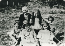
- Photograph of the Phillips family. Back row, left to right: Gladys Phillips (sister, later Gladys Comberbach), Marjorie Phillips (sister), and Christine Royal (neighbour). Front row, left to right: Norman Phillips (brother), Bessie Warne (cousin), and Muriel Phillips (sister). The Phillips' were th…
- Repository
- City of Burnaby Archives
- Date
- 1919 (date of original), copied 1986
- Collection/Fonds
- Burnaby Historical Society fonds
- Subseries
- Pioneer Tales subseries
- Physical Description
- 1 photograph : b&w ; 12.7 x 17.8 cm print
- Description Level
- Item
- Record No.
- 204-318
- Access Restriction
- No restrictions
- Reproduction Restriction
- No known restrictions
- Accession Number
- BHS1988-03
- Scope and Content
- Photograph of the Phillips family. Back row, left to right: Gladys Phillips (sister, later Gladys Comberbach), Marjorie Phillips (sister), and Christine Royal (neighbour). Front row, left to right: Norman Phillips (brother), Bessie Warne (cousin), and Muriel Phillips (sister). The Phillips' were the children of John Phillips and Lily Phillips (nee Warne), who owned and operated a dairy farm in South Burnaby. This photograph was taken near their 5670 Byrne Road farm and home.
- Names
- Comberbach, Gladys Phillips
- Phillips, Marjorie
- Phillips, Muriel
- Phillips, Norman
- Royal, Christine
- Warne, Bessie
- Media Type
- Photograph
- Notes
- Title based on contents of photograph
- Geographic Access
- Byrne Road
- Street Address
- 5670 Byrne Road
- Historic Neighbourhood
- Fraser Arm (Historic Neighbourhood)
- Planning Study Area
- Big Bend Area
Images
