Narrow Results By
Subject
- Aerial Photographs 2
- Buildings - Commercial 4
- Buildings - Commercial - Hardware Stores 4
- Buildings - Commercial - Restaurants
- Buildings - Industrial 4
- Buildings - Industrial - Factories 1
- Buildings - Residential - Apartments 1
- Foods 1
- Geographic Features - Automobile Parking Lots 1
- Geographic Features - Roads 1
- Natural Phenomena - Fires
- Occupations - Civic Workers
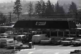
Captain George's Family Restaurant
https://search.heritageburnaby.ca/link/archivedescription79306
- Repository
- City of Burnaby Archives
- Date
- October, 1976
- Collection/Fonds
- Burnaby Public Library Contemporary Visual Archive Project
- Description Level
- Item
- Physical Description
- 1 photograph : b&w ; 11 x 16 cm mounted on cardboard
- Scope and Content
- Photograph shows Captain George's Family Restaurant at 5180 Lougheed Highway.
- Repository
- City of Burnaby Archives
- Date
- October, 1976
- Collection/Fonds
- Burnaby Public Library Contemporary Visual Archive Project
- Physical Description
- 1 photograph : b&w ; 11 x 16 cm mounted on cardboard
- Description Level
- Item
- Record No.
- 556-238
- Access Restriction
- No restrictions
- Reproduction Restriction
- Reproduce for fair dealing purposes only
- Accession Number
- 2013-13
- Scope and Content
- Photograph shows Captain George's Family Restaurant at 5180 Lougheed Highway.
- Subjects
- Buildings - Commercial - Restaurants
- Media Type
- Photograph
- Photographer
- Salmon, Stu
- Notes
- Scope note taken directly from BPL photograph description.
- 1 b&w copy negative : 10 x 12.5 cm accompanying
- Geographic Access
- Lougheed Highway
- Street Address
- 5180 Lougheed Highway
- Planning Study Area
- Dawson-Delta Area
Images


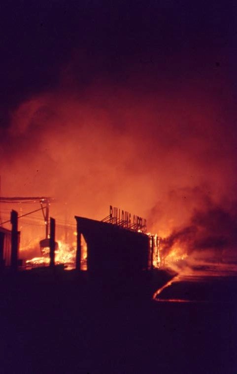
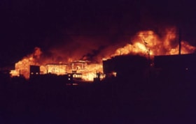
Nighttime fire at Lumberland
https://search.heritageburnaby.ca/link/museumdescription4312
- Repository
- Burnaby Village Museum
- Date
- 24 Aug. 1970
- Collection/Fonds
- Burnaby Village Museum Photograph collection
- Description Level
- Item
- Physical Description
- 1 photograph : col. ; 35 mm
- Scope and Content
- Photograph of a nighttime fire at Lumberland, located at 5650 Lougheed Highway.
- Repository
- Burnaby Village Museum
- Collection/Fonds
- Burnaby Village Museum Photograph collection
- Description Level
- Item
- Physical Description
- 1 photograph : col. ; 35 mm
- Material Details
- The slide was processed in Canachrome by Mortifee.
- Handwritten text in ink on slide frame reads: "Lumberland / Aug 24 /70".
- Scope and Content
- Photograph of a nighttime fire at Lumberland, located at 5650 Lougheed Highway.
- Names
- Farmer, Joanne
- Lumberland
- Geographic Access
- Lougheed Highway
- Street Address
- 5650 Lougheed Highway
- Accession Code
- BV017.42.7
- Access Restriction
- No restrictions
- Reproduction Restriction
- No known restrictions
- Date
- 24 Aug. 1970
- Media Type
- Photograph
- Planning Study Area
- Dawson-Delta Area
- Scan Resolution
- 600
- Scan Date
- 05-Jun-2018
- Notes
- Title based on content of photograph.
Images
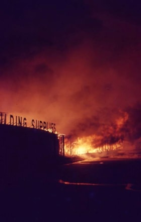
Nighttime fire at Lumberland
https://search.heritageburnaby.ca/link/museumdescription4313
- Repository
- Burnaby Village Museum
- Date
- 24 Aug. 1970
- Collection/Fonds
- Burnaby Village Museum Photograph collection
- Description Level
- Item
- Physical Description
- 1 photograph : col. ; 35 mm
- Scope and Content
- Photograph of a nighttime fire at Lumberland, located at 5650 Lougheed Highway.
- Repository
- Burnaby Village Museum
- Collection/Fonds
- Burnaby Village Museum Photograph collection
- Description Level
- Item
- Physical Description
- 1 photograph : col. ; 35 mm
- Material Details
- The slide was processed in Canachrome by Mortifee.
- Handwritten text in ink on slide frame reads: "Lumberland / Fire Aug 24 /70".
- Scope and Content
- Photograph of a nighttime fire at Lumberland, located at 5650 Lougheed Highway.
- Names
- Farmer, Joanne
- Lumberland
- Geographic Access
- Lougheed Highway
- Street Address
- 5650 Lougheed Highway
- Accession Code
- BV017.42.8
- Access Restriction
- No restrictions
- Reproduction Restriction
- No known restrictions
- Date
- 24 Aug. 1970
- Media Type
- Photograph
- Planning Study Area
- Dawson-Delta Area
- Scan Resolution
- 600
- Scan Date
- 05-Jun-2018
- Notes
- Title based on contents of photograph
Images


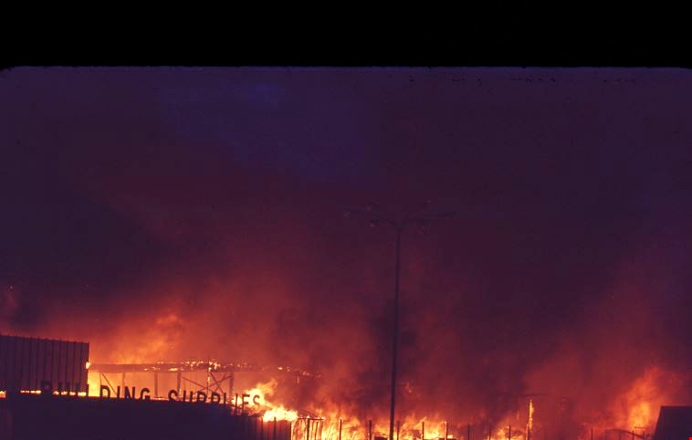
Nighttime fire at Lumberland
https://search.heritageburnaby.ca/link/museumdescription4314
- Repository
- Burnaby Village Museum
- Date
- 24 Aug. 1970
- Collection/Fonds
- Burnaby Village Museum Photograph collection
- Description Level
- Item
- Physical Description
- 1 photograph : col. ; 35 mm
- Scope and Content
- Photograph of a nighttime fire at Lumberland, located at 5650 Lougheed Highway.
- Repository
- Burnaby Village Museum
- Collection/Fonds
- Burnaby Village Museum Photograph collection
- Description Level
- Item
- Physical Description
- 1 photograph : col. ; 35 mm
- Material Details
- The slide was processed in Canachrome by Mortifee.
- Handwritten text in ink on slide frame reads: "Lumberland Fire / Aug 24 /70".
- Scope and Content
- Photograph of a nighttime fire at Lumberland, located at 5650 Lougheed Highway.
- Names
- Farmer, Joanne
- Lumberland
- Geographic Access
- Lougheed Highway
- Street Address
- 5650 Lougheed Highway
- Accession Code
- BV017.42.9
- Access Restriction
- No restrictions
- Reproduction Restriction
- No known restrictions
- Date
- 24 Aug. 1970
- Media Type
- Photograph
- Planning Study Area
- Dawson-Delta Area
- Scan Resolution
- 600
- Scan Date
- 05-Jun-2018
- Notes
- Title based on contents of photograph
Images
Nighttime fire at Lumberland
https://search.heritageburnaby.ca/link/museumdescription4315
- Repository
- Burnaby Village Museum
- Date
- 24 Aug. 1970
- Collection/Fonds
- Burnaby Village Museum Photograph collection
- Description Level
- Item
- Physical Description
- 1 photograph : col. ; 35 mm
- Scope and Content
- Photograph of a nighttime fire at Lumberland, located at 5650 Lougheed Highway.
- Repository
- Burnaby Village Museum
- Collection/Fonds
- Burnaby Village Museum Photograph collection
- Description Level
- Item
- Physical Description
- 1 photograph : col. ; 35 mm
- Material Details
- The slide was processed in Canachrome by Mortifee.
- Handwritten text in ink on slide frame reads: "Lumberland / Fire Aug 24 /70".
- Scope and Content
- Photograph of a nighttime fire at Lumberland, located at 5650 Lougheed Highway.
- Other Title Information
- Title based on content of photograph.
- Names
- Farmer, Joanne
- Lumberland
- Geographic Access
- Lougheed Highway
- Street Address
- 5650 Lougheed Highway
- Accession Code
- BV017.42.10
- Access Restriction
- No restrictions
- Reproduction Restriction
- No known restrictions
- Date
- 24 Aug. 1970
- Media Type
- Photograph
- Planning Study Area
- Dawson-Delta Area
- Scan Resolution
- 600
- Scan Date
- 05-Jun-2018
- Notes
- Title based on contents of photograph
Images

![Scott Robertson with recycling blue bins, [2001] thumbnail](/media/hpo/_Data/_Archives_Images/_Unrestricted/535/535-2260.jpg?width=280)
Scott Robertson with recycling blue bins
https://search.heritageburnaby.ca/link/archivedescription96638
- Repository
- City of Burnaby Archives
- Date
- [2001]
- Collection/Fonds
- Burnaby NewsLeader photograph collection
- Description Level
- Item
- Physical Description
- 1 photograph (tiff) : col.
- Scope and Content
- Photograph of Scott Robertson, an attendant at the Burnaby recycling depot, surrounded by recycling blue bins for distribution.
- Repository
- City of Burnaby Archives
- Date
- [2001]
- Collection/Fonds
- Burnaby NewsLeader photograph collection
- Physical Description
- 1 photograph (tiff) : col.
- Description Level
- Item
- Record No.
- 535-2260
- Access Restriction
- No restrictions
- Reproduction Restriction
- No restrictions
- Accession Number
- 2018-12
- Scope and Content
- Photograph of Scott Robertson, an attendant at the Burnaby recycling depot, surrounded by recycling blue bins for distribution.
- Media Type
- Photograph
- Photographer
- Bartel, Mario
- Notes
- Title based on caption
- Collected by editorial for use in an April 2001 issue of the Burnaby NewsLeader
- Caption from metadata: "Scott Robertson, an attendant at Burnaby's recycling depot, is surrounded by blue bins the city distributes to office and apartment buildings to recycle mixed paper and telephone books. Recycling is a major revenue producer for the city."
- Geographic Access
- Still Creek Drive
- Street Address
- 4855 Still Creek Drive
- Planning Study Area
- Dawson-Delta Area
Images
![Scott Robertson with recycling blue bins, [2001] thumbnail](/media/hpo/_Data/_Archives_Images/_Unrestricted/535/535-2260.jpg)