Narrow Results By
Subject
- Advertising Medium - Signs and Signboards 1
- Arts - Drawings 1
- Buildings - Commercial - Grocery Stores 3
- Buildings - Commercial - Hotels and Motels 1
- Buildings - Residential - Houses 7
- Buildings - Schools 8
- Construction 1
- Documentary Artifacts - Books 1
- Events - Royal Visits 1
- Geographic Features - Gardens 2
- Geographic Features - Lanes 1
- Occupations - Civic Workers 1

1982 - Moving the Roberts House
https://search.heritageburnaby.ca/link/archivedescription91893
- Repository
- City of Burnaby Archives
- Date
- 1982 (date of original), copied 2017
- Collection/Fonds
- Small family fonds
- Description Level
- Item
- Physical Description
- 1 photograph : col. copy print ; 10 cm x 15 cm
- Scope and Content
- Photograph of new houses being constructed on the 33 foot lots between 5496 Dominion Street and Douglas Road. Framing is complete and the houses' roofs and windows are installed.
- Repository
- City of Burnaby Archives
- Date
- 1982 (date of original), copied 2017
- Collection/Fonds
- Small family fonds
- Physical Description
- 1 photograph : col. copy print ; 10 cm x 15 cm
- Description Level
- Item
- Record No.
- 620-074
- Access Restriction
- No restrictions
- Reproduction Restriction
- No reproduction permitted
- Accession Number
- 2017-01
- Scope and Content
- Photograph of new houses being constructed on the 33 foot lots between 5496 Dominion Street and Douglas Road. Framing is complete and the houses' roofs and windows are installed.
- Media Type
- Photograph
- Notes
- Transcribed title
- Title transcribed from donor's notes
- Note in blue ink on verso of photograph reads: "P.16"
- Geographic Access
- Dominion Street
- Street Address
- 5496 Dominion Street
- Historic Neighbourhood
- Burnaby Lake (Historic Neighbourhood)
- Planning Study Area
- Ardingley-Sprott Area
Images


The "Back Lane"
https://search.heritageburnaby.ca/link/archivedescription91858
- Repository
- City of Burnaby Archives
- Date
- 1965
- Collection/Fonds
- Small family fonds
- Description Level
- Item
- Physical Description
- 1 photograph : b&w ; 9.5 cm x 9.5 cm
- Scope and Content
- Photograph of the back lane between Dominion Street and Norfolk Street. The lane is filled with trees, including a large cedar tree (centre) and cherry tree (left). The photograph was taken looking east along the lane. In 1965-66 the lane was put through from Douglas Road to Royal Oak and the tr…
- Repository
- City of Burnaby Archives
- Date
- 1965
- Collection/Fonds
- Small family fonds
- Physical Description
- 1 photograph : b&w ; 9.5 cm x 9.5 cm
- Description Level
- Item
- Record No.
- 620-039
- Access Restriction
- No restrictions
- Reproduction Restriction
- No reproduction permitted
- Accession Number
- 2017-01
- Scope and Content
- Photograph of the back lane between Dominion Street and Norfolk Street. The lane is filled with trees, including a large cedar tree (centre) and cherry tree (left). The photograph was taken looking east along the lane. In 1965-66 the lane was put through from Douglas Road to Royal Oak and the trees and undergrowth were removed.
- Media Type
- Photograph
- Notes
- Transcribed title
- Title transcribed from donor's notes
- Note in blue ink on verso of photograph reads: "P.2"
- Note in blue ink on verso of photograph reads: "Old Cedar Tree - chopped down for alley - Fall - 1965"
- Caption on border of recto of photograph reads: "Dec"
- Geographic Access
- Dominion Street
- Historic Neighbourhood
- Burnaby Lake (Historic Neighbourhood)
- Planning Study Area
- Ardingley-Sprott Area
Images

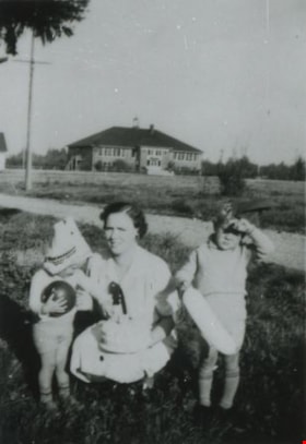
Dunn family
https://search.heritageburnaby.ca/link/archivedescription37683
- Repository
- City of Burnaby Archives
- Date
- October 1937 (date of original), copied 1991
- Collection/Fonds
- Burnaby Historical Society fonds
- Description Level
- Item
- Physical Description
- 1 photograph : b&w ; 4.1 x 2.8 cm print on contact sheet 20.2 x 25.3 cm
- Scope and Content
- Photograph of Ilma Dunn (centre) and her sons, Robert Dunn (left) and Fred Dunn (right), with 2nd Street School in the background. They each have toys in their hands. Robert is wearing a mask pushed to the top of his head.
- Repository
- City of Burnaby Archives
- Date
- October 1937 (date of original), copied 1991
- Collection/Fonds
- Burnaby Historical Society fonds
- Subseries
- Burnaby Image Bank subseries
- Physical Description
- 1 photograph : b&w ; 4.1 x 2.8 cm print on contact sheet 20.2 x 25.3 cm
- Description Level
- Item
- Record No.
- 370-271
- Access Restriction
- No restrictions
- Reproduction Restriction
- No known restrictions
- Accession Number
- BHS1999-03
- Scope and Content
- Photograph of Ilma Dunn (centre) and her sons, Robert Dunn (left) and Fred Dunn (right), with 2nd Street School in the background. They each have toys in their hands. Robert is wearing a mask pushed to the top of his head.
- Subjects
- Buildings - Schools
- Toys
- Media Type
- Photograph
- Notes
- Title based on contents of photograph
- 1 b&w copy negative accompanying
- Negative has a pink cast
- Geographic Access
- 2nd Street
- Street Address
- 7502 2nd Street
- Historic Neighbourhood
- East Burnaby (Historic Neighbourhood)
- Planning Study Area
- Second Street Area
Images

![Hands Across Havana at Second Street Community School, [2004] thumbnail](/media/hpo/_Data/_Archives_Images/_Unrestricted/535/535-2360.jpg?width=280)
Hands Across Havana at Second Street Community School
https://search.heritageburnaby.ca/link/archivedescription96802
- Repository
- City of Burnaby Archives
- Date
- [2004]
- Collection/Fonds
- Burnaby NewsLeader photograph collection
- Description Level
- Item
- Physical Description
- 1 photograph (tiff) : col.
- Scope and Content
- Photograph of three grade 6 students (Jordin Turpin, Emily Ford, and Keish McGinn) at Second Street Community School creating hand drawings for students in Cuba as part of their "Hands Across Havana" project.
- Repository
- City of Burnaby Archives
- Date
- [2004]
- Collection/Fonds
- Burnaby NewsLeader photograph collection
- Physical Description
- 1 photograph (tiff) : col.
- Description Level
- Item
- Record No.
- 535-2360
- Access Restriction
- No restrictions
- Reproduction Restriction
- No restrictions
- Accession Number
- 2018-12
- Scope and Content
- Photograph of three grade 6 students (Jordin Turpin, Emily Ford, and Keish McGinn) at Second Street Community School creating hand drawings for students in Cuba as part of their "Hands Across Havana" project.
- Subjects
- Persons - Students
- Arts - Drawings
- Names
- Second Street School
- Media Type
- Photograph
- Photographer
- Bartel, Mario
- Notes
- Title based on caption
- Collected by editorial for use in an April 2004 issue of the Burnaby NewsLeader
- Caption from metadata: "Jordin Turpin, Emily Ford and Keish McGinn, grade six students at Second St. Community School, demonstrate how they create hand drawings for students in Cuba as part of their "Hands Across Havana" project."
- Geographic Access
- 2nd Street
- Street Address
- 7502 2nd Street
- Historic Neighbourhood
- East Burnaby (Historic Neighbourhood)
- Planning Study Area
- Second Street Area
Images
![Hands Across Havana at Second Street Community School, [2004] thumbnail](/media/hpo/_Data/_Archives_Images/_Unrestricted/535/535-2360.jpg)

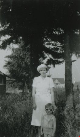
Illma Beamish Dunn and Robert Dunn
https://search.heritageburnaby.ca/link/archivedescription37682
- Repository
- City of Burnaby Archives
- Date
- 1938 (date of original), copied 1991
- Collection/Fonds
- Burnaby Historical Society fonds
- Description Level
- Item
- Physical Description
- 1 photograph : b&w ; 4.5 x 2.6 cm print on contact sheet 20.2 x 25.3 cm
- Scope and Content
- Photograph of Ilma Beamish Dunn and her son, Robert Dunn, in the front yard of their home at 1790 2nd Street (later renumbered as the 7400 block of 2nd Street). Second Street School is visible in the background. The photograph was taken during the summer of 1938.
- Repository
- City of Burnaby Archives
- Date
- 1938 (date of original), copied 1991
- Collection/Fonds
- Burnaby Historical Society fonds
- Subseries
- Burnaby Image Bank subseries
- Physical Description
- 1 photograph : b&w ; 4.5 x 2.6 cm print on contact sheet 20.2 x 25.3 cm
- Description Level
- Item
- Record No.
- 370-270
- Access Restriction
- No restrictions
- Reproduction Restriction
- No known restrictions
- Accession Number
- BHS1999-03
- Scope and Content
- Photograph of Ilma Beamish Dunn and her son, Robert Dunn, in the front yard of their home at 1790 2nd Street (later renumbered as the 7400 block of 2nd Street). Second Street School is visible in the background. The photograph was taken during the summer of 1938.
- Media Type
- Photograph
- Notes
- Title based on contents of photograph
- 1 b&w copy negative accompanying
- Negative has a pink cast
- Geographic Access
- 2nd Street
- Historic Neighbourhood
- East Burnaby (Historic Neighbourhood)
- Planning Study Area
- Second Street Area
Images
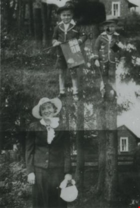
Illma, Fred and Robert Dunn
https://search.heritageburnaby.ca/link/archivedescription37685
- Repository
- City of Burnaby Archives
- Date
- May 1939 (date of original), copied 1991
- Collection/Fonds
- Burnaby Historical Society fonds
- Description Level
- Item
- Physical Description
- 1 photograph : b&w ; 4.2 x 2.8 cm print on contact sheet 20.2 x 25.3 cm
- Scope and Content
- Photograph is a double exposure; the first image is of Ilma Dunn; the second image is of Fred and Robert Dunn. In both exposures, the family members are standing in front of their home at 1790 2nd Street (later renumbered as the 7400 block of 2nd Street). They are dressed for a royal visit, and th…
- Repository
- City of Burnaby Archives
- Date
- May 1939 (date of original), copied 1991
- Collection/Fonds
- Burnaby Historical Society fonds
- Subseries
- Burnaby Image Bank subseries
- Physical Description
- 1 photograph : b&w ; 4.2 x 2.8 cm print on contact sheet 20.2 x 25.3 cm
- Material Details
- Photograph is a double exposure
- Description Level
- Item
- Record No.
- 370-273
- Access Restriction
- No restrictions
- Reproduction Restriction
- No known restrictions
- Accession Number
- BHS1999-03
- Scope and Content
- Photograph is a double exposure; the first image is of Ilma Dunn; the second image is of Fred and Robert Dunn. In both exposures, the family members are standing in front of their home at 1790 2nd Street (later renumbered as the 7400 block of 2nd Street). They are dressed for a royal visit, and the boys are carrying flags.
- Subjects
- Symbols - Flags
- Events - Royal Visits
- Media Type
- Photograph
- Notes
- Title based on contents of photograph
- 1 b&w copy negative accompanying
- Negative has a pink cast
- Geographic Access
- 2nd Street
- Historic Neighbourhood
- East Burnaby (Historic Neighbourhood)
- Planning Study Area
- Second Street Area
Images

![Interior of Model Grocery, [1914] date of original, copied [1973] thumbnail](/media/hpo/_Data/_BVM_Images/1973/1973_0098_0003_001.jpg?width=280)
Interior of Model Grocery
https://search.heritageburnaby.ca/link/museumdescription1007
- Repository
- Burnaby Village Museum
- Date
- [1914] date of original, copied [1973]
- Collection/Fonds
- Burnaby Village Museum Photograph collection
- Description Level
- Item
- Physical Description
- 1 photograph : b&w copy negative ; 10 x 12 cm
- Scope and Content
- Photograph of the interior of the Model Grocery store that stood at 2nd Street and 15th Ave, Burnaby. Three men (employees) are standing among the display of goods. An annotation on the back of the photograph identifies them as, left to right, Bill Moore, James Scott and Bill Hay. Some of the pr…
- Repository
- Burnaby Village Museum
- Collection/Fonds
- Burnaby Village Museum Photograph collection
- Description Level
- Item
- Physical Description
- 1 photograph : b&w copy negative ; 10 x 12 cm
- Scope and Content
- Photograph of the interior of the Model Grocery store that stood at 2nd Street and 15th Ave, Burnaby. Three men (employees) are standing among the display of goods. An annotation on the back of the photograph identifies them as, left to right, Bill Moore, James Scott and Bill Hay. Some of the products in view are fresh vegetables and fruits, White Swan Soaps, Robin Hood Porridge Oats, Royal Crown Soaps, Salada tea.
- Geographic Access
- 2nd Street
- 15th Avenue
- Accession Code
- HV973.98.3
- Access Restriction
- No restrictions
- Reproduction Restriction
- May be restricted by third party rights
- Date
- [1914] date of original, copied [1973]
- Media Type
- Photograph
- Historic Neighbourhood
- East Burnaby (Historic Neighbourhood)
- Planning Study Area
- Second Street Area
- Related Material
- According to catalogue record from 1976 and inscription on the back of the photograph, a taped interview with James Scott and Write up about the store are available in the BVM files.
- Scan Resolution
- 600
- Scan Date
- 2023-05-16
- Notes
- Title based on contents of photograph
- The photograph is a master print from negative HV973.98.4.
- Related materials: According to an annotation on the back of the photograph, a taped interview with James Scott [from 1975?] and a write-up about this store are in the Burnaby Village Museum archives
- 20.2 x 25.2 cm print
Images
![Interior of Model Grocery, [1914] date of original, copied [1973] thumbnail](/media/hpo/_Data/_BVM_Images/1973/1973_0098_0003_001.jpg)

Looking east along Dominion street to corner of Douglas Road and Dominion Street
https://search.heritageburnaby.ca/link/archivedescription91875
- Repository
- City of Burnaby Archives
- Date
- 1991
- Collection/Fonds
- Small family fonds
- Description Level
- Item
- Physical Description
- 1 photograph : col. copy print ; 10 cm x 15 cm
- Scope and Content
- Photograph of houses along Dominion Street, looking east with a tall hemlock, fir, and oak tree in the background. These houses were built after the Roberts' house was moved from 5538 Dominion Street to 5496 Dominion Street in 1982. The trees are the only three remaining from the original landsca…
- Repository
- City of Burnaby Archives
- Date
- 1991
- Collection/Fonds
- Small family fonds
- Physical Description
- 1 photograph : col. copy print ; 10 cm x 15 cm
- Description Level
- Item
- Record No.
- 620-056
- Access Restriction
- No restrictions
- Reproduction Restriction
- No reproduction permitted
- Accession Number
- 2017-01
- Scope and Content
- Photograph of houses along Dominion Street, looking east with a tall hemlock, fir, and oak tree in the background. These houses were built after the Roberts' house was moved from 5538 Dominion Street to 5496 Dominion Street in 1982. The trees are the only three remaining from the original landscaping of the Roberts' property in the late 1920s. The photograph was taken from the north side of the street, opposite 5496 Dominion Street.
- Media Type
- Photograph
- Notes
- Transcribed title
- Title transcribed from donor's notes
- Note in blue ink on verso of photograph reads: "P.18"
- Note in blue ink on verso of photograph reads: "Dominion St Summer 1991"
- The oak tree is the same tree as in photographs 620-007, 620-014, 620-015, and 620-016
- Geographic Access
- Dominion Street
- Street Address
- 5538 Dominion Street
- Historic Neighbourhood
- Burnaby Lake (Historic Neighbourhood)
- Planning Study Area
- Ardingley-Sprott Area
Images

Looking east along Dominion street to corner of Douglas Road and Dominion Street
https://search.heritageburnaby.ca/link/archivedescription91876
- Repository
- City of Burnaby Archives
- Date
- 2016
- Collection/Fonds
- Small family fonds
- Description Level
- Item
- Physical Description
- 1 photograph : col. ; 10 cm x 15 cm
- Scope and Content
- Photograph of Dominion Street, looking east. The houses are largely obscured by tall hedges and bushes. The photograph was taken from the north side of the street, opposite 5496 Dominion Street.
- Repository
- City of Burnaby Archives
- Date
- 2016
- Collection/Fonds
- Small family fonds
- Physical Description
- 1 photograph : col. ; 10 cm x 15 cm
- Description Level
- Item
- Record No.
- 620-057
- Access Restriction
- No restrictions
- Reproduction Restriction
- No reproduction permitted
- Accession Number
- 2017-01
- Scope and Content
- Photograph of Dominion Street, looking east. The houses are largely obscured by tall hedges and bushes. The photograph was taken from the north side of the street, opposite 5496 Dominion Street.
- Media Type
- Photograph
- Notes
- Transcribed title
- Title transcribed from donor's notes
- Note in blue ink on verso of photograph reads: "P.19"
- Note in blue ink on verso of photograph reads: "2016 / Looking East along Dominion St to corner of Douglas Rd. and Dominion St."
- Photograph 620-056 taken from the same vantage point
- Geographic Access
- Dominion Street
- Street Address
- 5538 Dominion Street
- Historic Neighbourhood
- Burnaby Lake (Historic Neighbourhood)
- Planning Study Area
- Ardingley-Sprott Area
Images


Looking southwest from corner of Douglas Road and Dominion Street
https://search.heritageburnaby.ca/link/archivedescription91877
- Repository
- City of Burnaby Archives
- Date
- 1978
- Collection/Fonds
- Small family fonds
- Description Level
- Item
- Physical Description
- 1 photograph : col. ; 9 cm x 13 cm
- Scope and Content
- Photograph of trees and a telephone pole situated at the southwest corner of Douglas Road and Dominion Street. The large oak, hemlock, and fir to the left of the telephone pole were planted as part of the original landscaping of the Roberts' property in the 1920s. The photograph was taken from th…
- Repository
- City of Burnaby Archives
- Date
- 1978
- Collection/Fonds
- Small family fonds
- Physical Description
- 1 photograph : col. ; 9 cm x 13 cm
- Description Level
- Item
- Record No.
- 620-058
- Access Restriction
- No restrictions
- Reproduction Restriction
- No reproduction permitted
- Accession Number
- 2017-01
- Scope and Content
- Photograph of trees and a telephone pole situated at the southwest corner of Douglas Road and Dominion Street. The large oak, hemlock, and fir to the left of the telephone pole were planted as part of the original landscaping of the Roberts' property in the 1920s. The photograph was taken from the Douglas Road and Dominion Street intersection.
- Media Type
- Photograph
- Notes
- Transcribed title
- Title transcribed from donor's notes
- Note in blue ink on verso of photograph reads: "P.20"
- Note in blue ink on verso of photograph reads: "Photo 1978"
- Note in black ink on verso of photograph reads: "Looking at S.W. corner of Douglas Rd and Dominion Street, from intersection / Oak tree, hemlock tree, and fir tree, Japanese Plum Tree"
- The oak tree is the same tree as in photographs 620-007, 620-014, 620-015, and 620-016
- Geographic Access
- Dominion Street
- Douglas Road
- Historic Neighbourhood
- Burnaby Lake (Historic Neighbourhood)
- Planning Study Area
- Ardingley-Sprott Area
Images


Looking southwest from corner of Douglas Road and Dominion Street
https://search.heritageburnaby.ca/link/archivedescription91878
- Repository
- City of Burnaby Archives
- Date
- April 2015
- Collection/Fonds
- Small family fonds
- Description Level
- Item
- Physical Description
- 1 photograph : col. copy print ; 10 cm x 15 cm
- Scope and Content
- Photograph of the houses and trees situated on the southwest corner of Douglas Road and Dominion Street. The large oak, hemlock, and fir were planted as part of the original landscaping of the Roberts' property in the 1920s. The photograph was taken from the Douglas Road and Dominion Street inter…
- Repository
- City of Burnaby Archives
- Date
- April 2015
- Collection/Fonds
- Small family fonds
- Physical Description
- 1 photograph : col. copy print ; 10 cm x 15 cm
- Description Level
- Item
- Record No.
- 620-059
- Access Restriction
- No restrictions
- Reproduction Restriction
- No reproduction permitted
- Accession Number
- 2017-01
- Scope and Content
- Photograph of the houses and trees situated on the southwest corner of Douglas Road and Dominion Street. The large oak, hemlock, and fir were planted as part of the original landscaping of the Roberts' property in the 1920s. The photograph was taken from the Douglas Road and Dominion Street intersection.
- Media Type
- Photograph
- Notes
- Transcribed title
- Title transcribed from donor's notes
- Note in blue ink on verso of photograph reads: "P.21"
- Note in blue ink on verso of photograph reads: "Looking southwest from corner of Douglas Rd. and Dominion St. / Oak Tree Hemlock Tree Fir Tree / planted in late 1920's"
- Note in black ink on verso of photograph reads: "April 2015"
- The oak tree is the same tree as in photographs 620-007, 620-014, 620-015, and 620-016
- Geographic Access
- Dominion Street
- Douglas Road
- Historic Neighbourhood
- Burnaby Lake (Historic Neighbourhood)
- Planning Study Area
- Ardingley-Sprott Area
Images


Looking west along Dominion Street from across the street from 5496 Dominion Street
https://search.heritageburnaby.ca/link/archivedescription91874
- Repository
- City of Burnaby Archives
- Date
- July 2016
- Collection/Fonds
- Small family fonds
- Description Level
- Item
- Physical Description
- 1 photograph : col. copy print ; 10 cm x 15 cm
- Scope and Content
- Photograph of the houses along the south side of Dominion Street with cars parked along the curb. In 2009 sidewalks were installed and the street was repaved under a neighbourhood local improvement request to the City. The photograph was taken from the north side of the street, opposite 5496 Dom…
- Repository
- City of Burnaby Archives
- Date
- July 2016
- Collection/Fonds
- Small family fonds
- Physical Description
- 1 photograph : col. copy print ; 10 cm x 15 cm
- Description Level
- Item
- Record No.
- 620-055
- Access Restriction
- No restrictions
- Reproduction Restriction
- No reproduction permitted
- Accession Number
- 2017-01
- Scope and Content
- Photograph of the houses along the south side of Dominion Street with cars parked along the curb. In 2009 sidewalks were installed and the street was repaved under a neighbourhood local improvement request to the City. The photograph was taken from the north side of the street, opposite 5496 Dominion Street, looking west.
- Media Type
- Photograph
- Notes
- Transcribed title
- Title transcribed from donor's notes
- Note in blue ink on verso of photograph reads: "P.17"
- Note in blue ink on verso of photograph reads: "Dominion St. infilled with houses on 33' lots / Photo July 2016"
- Geographic Access
- Dominion Street
- Historic Neighbourhood
- Burnaby Lake (Historic Neighbourhood)
- Planning Study Area
- Ardingley-Sprott Area
Images


Looking west from back yard of 5496 Dominion Street
https://search.heritageburnaby.ca/link/archivedescription91866
- Repository
- City of Burnaby Archives
- Date
- April 1, 2015
- Collection/Fonds
- Small family fonds
- Description Level
- Item
- Physical Description
- 1 photograph : col. copy print ; 10 cm x 15 cm
- Scope and Content
- Photograph of the backyard at 5496 Dominion Street, looking west, with the houses on Norfolk Street (left) and Dominion Street (right) visible in the background.
- Repository
- City of Burnaby Archives
- Date
- April 1, 2015
- Collection/Fonds
- Small family fonds
- Physical Description
- 1 photograph : col. copy print ; 10 cm x 15 cm
- Description Level
- Item
- Record No.
- 620-047
- Access Restriction
- No restrictions
- Reproduction Restriction
- No reproduction permitted
- Accession Number
- 2017-01
- Scope and Content
- Photograph of the backyard at 5496 Dominion Street, looking west, with the houses on Norfolk Street (left) and Dominion Street (right) visible in the background.
- Media Type
- Photograph
- Notes
- Transcribed title
- Title transcribed from donor's notes
- Note in blue ink on verso of photograph reads: "P.10"
- Note in black ink on verso of photograph reads: "April 1, 2015"
- Geographic Access
- Dominion Street
- Norfolk Street
- Street Address
- 5496 Dominion Street
- Historic Neighbourhood
- Burnaby Lake (Historic Neighbourhood)
- Planning Study Area
- Ardingley-Sprott Area
Images

![Massey women, [195-] (date of original), copied 2014 thumbnail](/media/hpo/_Data/_Archives_Images/_Unrestricted/580/581-007.jpg?width=280)
Massey women
https://search.heritageburnaby.ca/link/archivedescription88401
- Repository
- City of Burnaby Archives
- Date
- [195-] (date of original), copied 2014
- Collection/Fonds
- James Massey family fonds
- Description Level
- Item
- Physical Description
- 1 photograph (tiff) : sepia ; 600 dpi
- Scope and Content
- Photograph of Alice Massey and her daughters standing outside on the lawn in front of their new home on Second Street in Burnaby. Women are identified from left to right as; Grace Jackson (nee Massey), Evelyn McCallum (nee Massey), Alice Massey and Betty Massey.
- Repository
- City of Burnaby Archives
- Date
- [195-] (date of original), copied 2014
- Collection/Fonds
- James Massey family fonds
- Physical Description
- 1 photograph (tiff) : sepia ; 600 dpi
- Description Level
- Item
- Record No.
- 581-007
- Access Restriction
- No restrictions
- Reproduction Restriction
- No reproduction permitted
- Accession Number
- 2014-34
- Scope and Content
- Photograph of Alice Massey and her daughters standing outside on the lawn in front of their new home on Second Street in Burnaby. Women are identified from left to right as; Grace Jackson (nee Massey), Evelyn McCallum (nee Massey), Alice Massey and Betty Massey.
- Media Type
- Photograph
- Notes
- Title based on contents of photograph
- Geographic Access
- 2nd Street
- Historic Neighbourhood
- East Burnaby (Historic Neighbourhood)
- Planning Study Area
- Second Street Area
Images
![Massey women, [195-] (date of original), copied 2014 thumbnail](/media/hpo/_Data/_Archives_Images/_Unrestricted/580/581-007.jpg)
![Model Grocery, [1914] (date of original), copied [1973] thumbnail](/media/hpo/_Data/_BVM_Images/1973/1973_0098_0001_001.jpg?width=280)
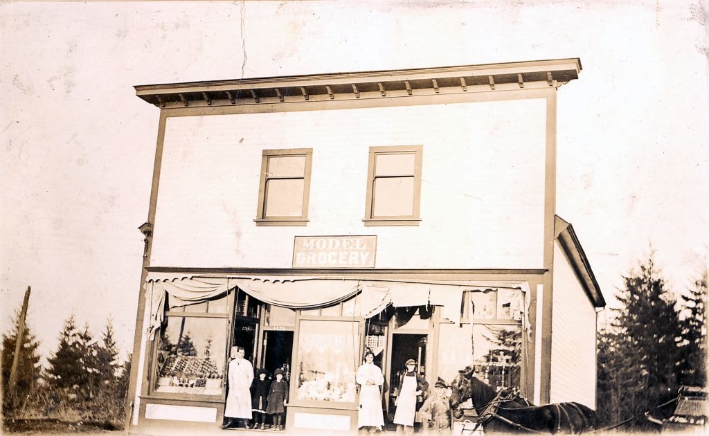
Model Grocery
https://search.heritageburnaby.ca/link/museumdescription3069
- Repository
- Burnaby Village Museum
- Date
- [1914] (date of original), copied [1973]
- Collection/Fonds
- Burnaby Village Museum Photograph collection
- Description Level
- Item
- Physical Description
- 1 photograph : b&w ; 20.1 x 25.1 cm print
- Scope and Content
- Photograph of Bill Hay (on left) and James Scott standing at the front entrance to the Model Grocery Store, situated at 2nd Street and 15th Avenue in Burnaby. The store has wooden shiplap siding all around and a peaked roof with a tall false front with a wide cornice at the top. The righthand side …
- Repository
- Burnaby Village Museum
- Collection/Fonds
- Burnaby Village Museum Photograph collection
- Description Level
- Item
- Physical Description
- 1 photograph : b&w ; 20.1 x 25.1 cm print
- Scope and Content
- Photograph of Bill Hay (on left) and James Scott standing at the front entrance to the Model Grocery Store, situated at 2nd Street and 15th Avenue in Burnaby. The store has wooden shiplap siding all around and a peaked roof with a tall false front with a wide cornice at the top. The righthand side of the eaves show, and the details of the gutter and downspout are clearly visible. The bottom front of the building is all one store. Display windows fill the front in three sections. On the extreme left and right are two wide windows. In the centre is another narrower window. Between these windows are two doors, set in about five feet. A canvas awning (furled) spans the store over the windows. Inside the windows, displays are visible. In the right hand window are stacks of tinned goods. In the centre, flats of fruit set up to face outwards. In the left window is a large display of White Swan soap. Below the right and left windows are small enamelled signs advertising Fleischman's Yeast. No other sign or advertising is visible on the exterior. In the right hand doorway is a display of washboard and corn brooms. A canvas covered horse drawn delivery wagon with a "308 6th St. Model Grocery" sign is positioned to the right rear of the store.
- Geographic Access
- 2nd Street
- 15th Avenue
- Accession Code
- HV973.98.1
- Access Restriction
- No restrictions
- Reproduction Restriction
- May be restricted by third party rights
- Date
- [1914] (date of original), copied [1973]
- Media Type
- Photograph
- Historic Neighbourhood
- East Burnaby (Historic Neighbourhood)
- Planning Study Area
- Second Street Area
- Related Material
- According to catalogue record from 1976, a taped interview with James Scott and Write up about the store are available in the BVM files.
- Scan Resolution
- 600
- Scan Date
- 2023-05-16
- Notes
- Title based on contents of photograph
- See HV973.98.2 for original negative associated with this copy print
- Related materials: According to a note with the photograph, a taped interview with James Scott (1975) and a write-up about this store are in the Burnaby Village Museum archives
Images
![Model Grocery, [1914] (date of original), copied [1973] thumbnail](/media/hpo/_Data/_BVM_Images/1973/1973_0098_0001_001.jpg)

Model Grocery store
https://search.heritageburnaby.ca/link/museumdescription2651
- Repository
- Burnaby Village Museum
- Date
- 1916 (date of original)
- Collection/Fonds
- Burnaby Village Museum Photograph collection
- Description Level
- Item
- Physical Description
- 1 photograph : sepia ; 300 ppi
- Scope and Content
- Photograph of the Model Grocery store in East Burnaby.
- Repository
- Burnaby Village Museum
- Collection/Fonds
- Burnaby Village Museum Photograph collection
- Description Level
- Item
- Physical Description
- 1 photograph : sepia ; 300 ppi
- Scope and Content
- Photograph of the Model Grocery store in East Burnaby.
- Names
- Model Grocery
- Geographic Access
- 2nd Street
- 15th Avenue
- Accession Code
- BV004.115.26
- Access Restriction
- No restrictions
- Date
- 1916 (date of original)
- Media Type
- Photograph
- Historic Neighbourhood
- East Burnaby (Historic Neighbourhood)
- Planning Study Area
- Second Street Area
- Notes
- Title based on contents of photograph
Images
![Second Street Community School garden, [2000] thumbnail](/media/hpo/_Data/_Archives_Images/_Unrestricted/535/535-2425.jpg?width=280)
Second Street Community School garden
https://search.heritageburnaby.ca/link/archivedescription96867
- Repository
- City of Burnaby Archives
- Date
- [2000]
- Collection/Fonds
- Burnaby NewsLeader photograph collection
- Description Level
- Item
- Physical Description
- 1 photograph (tiff) : col.
- Scope and Content
- Photograph of students Amanda Wilkes, Chantal Vicente, and Michael Gerow in the community garden at Second Street Community School.
- Repository
- City of Burnaby Archives
- Date
- [2000]
- Collection/Fonds
- Burnaby NewsLeader photograph collection
- Physical Description
- 1 photograph (tiff) : col.
- Description Level
- Item
- Record No.
- 535-2425
- Access Restriction
- No restrictions
- Reproduction Restriction
- No restrictions
- Accession Number
- 2018-12
- Scope and Content
- Photograph of students Amanda Wilkes, Chantal Vicente, and Michael Gerow in the community garden at Second Street Community School.
- Names
- Second Street School
- Media Type
- Photograph
- Photographer
- Bartel, Mario
- Notes
- Title based on caption
- Collected by editorial for use in a May 2000 issue of the Burnaby NewsLeader
- Caption from metadata: "Amanada Wilkes plants in the garden, while Chantal Vicente and Michael Gerow enjoy a book on a park bench, in the community garden at Second Street Community School. The school recently received a provincial grant to add the benches and other features to the garden."
- Geographic Access
- 2nd Street
- Street Address
- 7502 2nd Street
- Historic Neighbourhood
- East Burnaby (Historic Neighbourhood)
- Planning Study Area
- Second Street Area
Images
![Second Street Community School garden, [2000] thumbnail](/media/hpo/_Data/_Archives_Images/_Unrestricted/535/535-2425.jpg)
![Second Street School, [January 1978] thumbnail](/media/hpo/_Data/_Archives_Images/_Unrestricted/550/556-621.jpg?width=280)
Second Street School
https://search.heritageburnaby.ca/link/archivedescription93664
- Repository
- City of Burnaby Archives
- Date
- [January 1978]
- Collection/Fonds
- Burnaby Public Library Contemporary Visual Archive Project
- Description Level
- Item
- Physical Description
- 1 photograph : b&w ; 12.5 x 17.5 cm
- Scope and Content
- Photograph of the schoolyard and exterior of Second Street School. The photograph is taken from across the field, facing east. The photograph shows children playing in the field and the old school building, built in 1928, and the newer additions to the school. The mountains are visible in the backg…
- Repository
- City of Burnaby Archives
- Date
- [January 1978]
- Collection/Fonds
- Burnaby Public Library Contemporary Visual Archive Project
- Physical Description
- 1 photograph : b&w ; 12.5 x 17.5 cm
- Description Level
- Item
- Record No.
- 556-621
- Access Restriction
- No restrictions
- Reproduction Restriction
- Reproduce for fair dealing purposes only
- Accession Number
- 2017-57
- Scope and Content
- Photograph of the schoolyard and exterior of Second Street School. The photograph is taken from across the field, facing east. The photograph shows children playing in the field and the old school building, built in 1928, and the newer additions to the school. The mountains are visible in the background.
- Subjects
- Buildings - Schools
- Names
- Second Street School
- Media Type
- Photograph
- Photographer
- Surridge, Jack
- Notes
- Title taken from project information form
- Accompanied by a project information form and 1 photograph (b&w negative ; 9.5 x 12.5 cm)
- BPL no. 70
- Geographic Access
- 2nd Street
- Street Address
- 7502 2nd Street
- Historic Neighbourhood
- East Burnaby (Historic Neighbourhood)
- Planning Study Area
- Second Street Area
Images
![Second Street School, [January 1978] thumbnail](/media/hpo/_Data/_Archives_Images/_Unrestricted/550/556-621.jpg)
![Second Street School, [between 1913 and 1919] thumbnail](/media/hpo/_Data/_Archives_Images/_Unrestricted/316/325-032.jpg?width=280)
Second Street School
https://search.heritageburnaby.ca/link/archivedescription37160
- Repository
- City of Burnaby Archives
- Date
- [between 1913 and 1919]
- Collection/Fonds
- Burnaby Historical Society fonds
- Description Level
- Item
- Physical Description
- 1 photograph : b&w ; 7.5 x 10 cm print
- Scope and Content
- Photograph of Second Street School taken from a distance.
- Repository
- City of Burnaby Archives
- Date
- [between 1913 and 1919]
- Collection/Fonds
- Burnaby Historical Society fonds
- Subseries
- Disney family subseries
- Physical Description
- 1 photograph : b&w ; 7.5 x 10 cm print
- Description Level
- Item
- Record No.
- 325-032
- Access Restriction
- No restrictions
- Reproduction Restriction
- No known restrictions
- Accession Number
- BHS1996-04
- Scope and Content
- Photograph of Second Street School taken from a distance.
- Subjects
- Buildings - Schools
- Names
- Second Street School
- Media Type
- Photograph
- Photographer
- Disney, John Harold "Jack"
- Notes
- Title based on contents of photograph
- Geographic Access
- 2nd Street
- Street Address
- 7502 2nd Street
- Historic Neighbourhood
- East Burnaby (Historic Neighbourhood)
- Planning Study Area
- Second Street Area
Images
![Second Street School, [between 1913 and 1919] thumbnail](/media/hpo/_Data/_Archives_Images/_Unrestricted/316/325-032.jpg)
![Second Street School, [between 1913 and 1919] thumbnail](/media/hpo/_Data/_Archives_Images/_Unrestricted/316/325-033.jpg?width=280)
Second Street School
https://search.heritageburnaby.ca/link/archivedescription37161
- Repository
- City of Burnaby Archives
- Date
- [between 1913 and 1919]
- Collection/Fonds
- Burnaby Historical Society fonds
- Description Level
- Item
- Physical Description
- 1 photograph : b&w ; 8 x 12.5 cm print
- Scope and Content
- Photograph of Second Street School.
- Repository
- City of Burnaby Archives
- Date
- [between 1913 and 1919]
- Collection/Fonds
- Burnaby Historical Society fonds
- Subseries
- Disney family subseries
- Physical Description
- 1 photograph : b&w ; 8 x 12.5 cm print
- Description Level
- Item
- Record No.
- 325-033
- Access Restriction
- No restrictions
- Reproduction Restriction
- No known restrictions
- Accession Number
- BHS1996-04
- Scope and Content
- Photograph of Second Street School.
- Subjects
- Buildings - Schools
- Names
- Second Street School
- Media Type
- Photograph
- Photographer
- Disney, John Harold "Jack"
- Notes
- Title based on contents of photograph
- Geographic Access
- 2nd Street
- Street Address
- 7502 2nd Street
- Historic Neighbourhood
- East Burnaby (Historic Neighbourhood)
- Planning Study Area
- Second Street Area
Images
![Second Street School, [between 1913 and 1919] thumbnail](/media/hpo/_Data/_Archives_Images/_Unrestricted/316/325-033.jpg)