Narrow Results By
Subject
- Accidents 14
- Accidents - Automobile Accidents 30
- Accidents - Train Accidents 23
- Adminstrative Groups - Committees 4
- Adornment - Jewelry 7
- Adornment - Lapel Pins 1
- Advertising Medium 11
- Advertising Medium - Flyer 3
- Advertising Medium - Poster 16
- Advertising Medium - Signs and Signboards 221
- Aerial Photographs 132
- Agricultural Tools and Equipment 22
Person / Organization
- Bancroft, Rose 2
- British Columbia Electric Railway Company 1
- Burnaby Advisory Planning Commission 1
- Burnaby Historical Society 2
- Burnaby Village Museum 2
- Canadian Lead and Alloys Limited 1
- Carleton Sash and Door Company 1
- Cliff's Can Factory 4
- Continental Can Co. 2
- Dominion Bridge Company 3
- Ford Motor Company 1
- James Brookes Woodworking Limited 4
![Aerial map of Burnaby Mountain, [1995] thumbnail](/media/Hpo/_Data/_Archives_Images/_Unrestricted/629/629-006.jpg?width=280)
Aerial map of Burnaby Mountain
https://search.heritageburnaby.ca/link/archivedescription97805
- Repository
- City of Burnaby Archives
- Date
- [1995]
- Collection/Fonds
- Burnaby Mountain Preservation Society fonds
- Description Level
- Item
- Physical Description
- 1 photograph : col. slide ; 35 mm
- Scope and Content
- Aerial map of Burnaby Mountain.
- Repository
- City of Burnaby Archives
- Date
- [1995]
- Collection/Fonds
- Burnaby Mountain Preservation Society fonds
- Physical Description
- 1 photograph : col. slide ; 35 mm
- Description Level
- Item
- Record No.
- 629-006
- Access Restriction
- No restrictions
- Reproduction Restriction
- Reproduce for fair dealing purposes only
- Accession Number
- 2006-13
- Scope and Content
- Aerial map of Burnaby Mountain.
- Subjects
- Documentary Artifacts - Maps
- Media Type
- Photograph
- Geographic Access
- Burnaby Mountain Conservation Area
- Planning Study Area
- Burnaby Mountain Area
Images
![Aerial map of Burnaby Mountain, [1995] thumbnail](/media/Hpo/_Data/_Archives_Images/_Unrestricted/629/629-006.jpg)
Brickyard
https://search.heritageburnaby.ca/link/archivedescription38403
- Repository
- City of Burnaby Archives
- Date
- 1898
- Collection/Fonds
- Burnaby Historical Society fonds
- Description Level
- Item
- Physical Description
- 1 photograph : sepia ; 10 x 12.5 cm
- Scope and Content
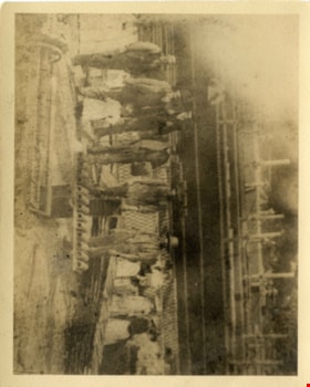
- Photograph of a group of fourteen people standing in a brickyard. This is believed to be one of the Brickyards co-owned by James Gilmore Ettinger (one was in Burnaby, the other in Surrey).
- Repository
- City of Burnaby Archives
- Date
- 1898
- Collection/Fonds
- Burnaby Historical Society fonds
- Subseries
- Ettinger family subseries
- Physical Description
- 1 photograph : sepia ; 10 x 12.5 cm
- Description Level
- Item
- Record No.
- 428-002
- Access Restriction
- No restrictions
- Reproduction Restriction
- No known restrictions
- Accession Number
- BHS2002-03
- Scope and Content
- Photograph of a group of fourteen people standing in a brickyard. This is believed to be one of the Brickyards co-owned by James Gilmore Ettinger (one was in Burnaby, the other in Surrey).
- Subjects
- Buildings - Industrial - Factories
- Media Type
- Photograph
- Notes
- Title based on contents of photograph
Images

Burnaby Advisory Planning Commission records
https://search.heritageburnaby.ca/link/archivedescription82740
- Repository
- City of Burnaby Archives
- Date
- [1971-1996]
- Collection/Fonds
- Hazel Simnett collection
- Description Level
- File
- Physical Description
- 1 file of textual records ; 1 map ; 1 pin
- Scope and Content
- File consists of three letters, one envelope, a booklet, a map, a pin and a business card. The first letter found in the envelope from the Department of the Municipal Clerk is addressed to Hazel Simnett and approves her appointment to the Advisory Planning Commission in 1993. The second letter date…
- Repository
- City of Burnaby Archives
- Date
- [1971-1996]
- Collection/Fonds
- Hazel Simnett collection
- Physical Description
- 1 file of textual records ; 1 map ; 1 pin
- Description Level
- File
- Record No.
- MSS167-010
- Accession Number
- 2013-22
- Scope and Content
- File consists of three letters, one envelope, a booklet, a map, a pin and a business card. The first letter found in the envelope from the Department of the Municipal Clerk is addressed to Hazel Simnett and approves her appointment to the Advisory Planning Commission in 1993. The second letter dated March 17, 1995 is addressed to Hazel Simnett and approves her reappointment to the Advisory Planning Commission. The booklet is of the Burnaby Procedure Bylaw 1971 (bylaw number 6023 to regulate the proceedings of the Municipal Council of The Corporation of the District of Burnaby). The map is a street map of the Burnaby Planning & Building Department from 1992. The second letter is typewritten by Hazel Simnett to Mayor W. Copeland in 1996 regarding her resignation from the Advisory Planning Commission. The pin reads: "Burnaby Advisory Planning Commission". The business card is of Donald G. Stenson, Director Planning and Building of the Burnaby Planning and Building Department.
- Media Type
- Textual Record
- Cartographic Material
- Notes
- Title based on note accompanying file
- Simnett political papers series

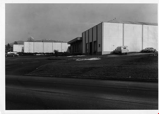
Canadian Lead and Alloys Ltd.
https://search.heritageburnaby.ca/link/archivedescription34587
- Repository
- City of Burnaby Archives
- Date
- 1958
- Collection/Fonds
- Burnaby Historical Society fonds
- Description Level
- Item
- Physical Description
- 1 photograph : b&w ; 20.5 x 25.7 cm
- Scope and Content
- Photograph of the exterior of the Canadian Lead and Alloys Ltd. building at 2345 Douglas Road.
- Repository
- City of Burnaby Archives
- Date
- 1958
- Collection/Fonds
- Burnaby Historical Society fonds
- Subseries
- Photographs subseries
- Physical Description
- 1 photograph : b&w ; 20.5 x 25.7 cm
- Description Level
- Item
- Record No.
- 061-001
- Access Restriction
- No restrictions
- Reproduction Restriction
- Reproduce for fair dealing purposes only
- Accession Number
- BHS2007-04
- Scope and Content
- Photograph of the exterior of the Canadian Lead and Alloys Ltd. building at 2345 Douglas Road.
- Subjects
- Buildings - Industrial - Factories
- Media Type
- Photograph
- Notes
- Title based on contents of photograph
- Street Address
- 2345 Douglas Road
- Planning Study Area
- Dawson-Delta Area
Images

![Carleton Sash and Door Factory, [1912] (date of original), copied 1986 thumbnail](/media/hpo/_Data/_Archives_Images/_Unrestricted/204/204-611.jpg?width=280)
Carleton Sash and Door Factory
https://search.heritageburnaby.ca/link/archivedescription35753
- Repository
- City of Burnaby Archives
- Date
- [1912] (date of original), copied 1986
- Collection/Fonds
- Burnaby Historical Society fonds
- Description Level
- Item
- Physical Description
- 1 photograph : b&w ; 12.7 x 17.8 cm print
- Scope and Content
- Photograph of the interior of Carleton Sash and Door factory in the Collingwood district (Kingsway-Joyce area) of Vancouver near Collingwood School. Collingwood is located next to Burnaby. The factory was founded by Friedrich Engelland.
- Repository
- City of Burnaby Archives
- Date
- [1912] (date of original), copied 1986
- Collection/Fonds
- Burnaby Historical Society fonds
- Subseries
- Pioneer Tales subseries
- Physical Description
- 1 photograph : b&w ; 12.7 x 17.8 cm print
- Description Level
- Item
- Record No.
- 204-611
- Access Restriction
- No restrictions
- Reproduction Restriction
- No known restrictions
- Accession Number
- BHS1988-03
- Scope and Content
- Photograph of the interior of Carleton Sash and Door factory in the Collingwood district (Kingsway-Joyce area) of Vancouver near Collingwood School. Collingwood is located next to Burnaby. The factory was founded by Friedrich Engelland.
- Media Type
- Photograph
- Notes
- Title based on contents of photograph
Images
![Carleton Sash and Door Factory, [1912] (date of original), copied 1986 thumbnail](/media/hpo/_Data/_Archives_Images/_Unrestricted/204/204-611.jpg)
![City of Burnaby digital mapping system, [2002] thumbnail](/media/hpo/_Data/_Archives_Images/_Unrestricted/535/535-2325.jpg?width=280)
City of Burnaby digital mapping system
https://search.heritageburnaby.ca/link/archivedescription96720
- Repository
- City of Burnaby Archives
- Date
- [2002]
- Collection/Fonds
- Burnaby NewsLeader photograph collection
- Description Level
- Item
- Physical Description
- 1 photograph (tiff) : col.
- Scope and Content
- Photograph of Terry Richard, from the City of Burnaby Engineering Department, posing with a map of Burnaby and a desktop computer displaying the City's new digital mapping system.
- Repository
- City of Burnaby Archives
- Date
- [2002]
- Collection/Fonds
- Burnaby NewsLeader photograph collection
- Physical Description
- 1 photograph (tiff) : col.
- Description Level
- Item
- Record No.
- 535-2325
- Access Restriction
- No restrictions
- Reproduction Restriction
- No restrictions
- Accession Number
- 2018-12
- Scope and Content
- Photograph of Terry Richard, from the City of Burnaby Engineering Department, posing with a map of Burnaby and a desktop computer displaying the City's new digital mapping system.
- Media Type
- Photograph
- Photographer
- Bartel, Mario
- Notes
- Title based on caption
- Collected by editorial for use in an April 2002 issue of the Burnaby NewsLeader
- Caption from metadata: "Terry Richard, of Burnaby's Engineering Department, is overseeing the transfer of its mapping system to the internet."
Images
![City of Burnaby digital mapping system, [2002] thumbnail](/media/hpo/_Data/_Archives_Images/_Unrestricted/535/535-2325.jpg)
Construction of the Labatt Plant
https://search.heritageburnaby.ca/link/archivedescription58931
- Repository
- City of Burnaby Archives
- Date
- 1983
- Collection/Fonds
- Columbian Newspaper collection
- Description Level
- Item
- Physical Description
- 1 photograph : b&w ; 25 x 20.5 cm
- Scope and Content
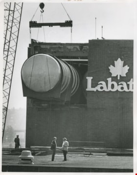
- Photograph of the construction of the Labatt brewery. A crane is lifting a large pipe into the building and two men stand below, talking.
- Repository
- City of Burnaby Archives
- Date
- 1983
- Collection/Fonds
- Columbian Newspaper collection
- Physical Description
- 1 photograph : b&w ; 25 x 20.5 cm
- Description Level
- Item
- Record No.
- 480-1381
- Access Restriction
- No restrictions
- Reproduction Restriction
- Reproduce for fair dealing purposes only
- Accession Number
- 2009-01
- Scope and Content
- Photograph of the construction of the Labatt brewery. A crane is lifting a large pipe into the building and two men stand below, talking.
- Media Type
- Photograph
- Notes
- Title based on contents of photograph
- Note on verso reads: "PMT 100% / page B-3 / Burnaby Today"
Images

Construction of the Steel Service Centre
https://search.heritageburnaby.ca/link/archivedescription45612
- Repository
- City of Burnaby Archives
- Date
- April 1976
- Collection/Fonds
- Columbian Newspaper collection
- Description Level
- Item
- Physical Description
- 1 photograph : b&w ; 14 x 19.5 cm
- Scope and Content
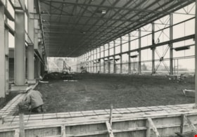
- Photograph of the construction of the Dominion Bridge Steel Service Centre. Dominion Bridge Co. closed down its Burnaby fabricating plant which employed 350 workers and opened this in Delta which employed only 50 of those workers, putting 300 employess out of work.
- Repository
- City of Burnaby Archives
- Date
- April 1976
- Collection/Fonds
- Columbian Newspaper collection
- Physical Description
- 1 photograph : b&w ; 14 x 19.5 cm
- Description Level
- Item
- Record No.
- 480-506
- Access Restriction
- No restrictions
- Reproduction Restriction
- No restrictions
- Accession Number
- 2003-02
- Scope and Content
- Photograph of the construction of the Dominion Bridge Steel Service Centre. Dominion Bridge Co. closed down its Burnaby fabricating plant which employed 350 workers and opened this in Delta which employed only 50 of those workers, putting 300 employess out of work.
- Names
- Dominion Bridge Company
- Media Type
- Photograph
- Photographer
- King, Basil
- Notes
- Title based on contents of photograph
- Newspaper clipping attached to verso of photograph reads: "More than 600 tons of structural steel are being assembled on Annacis Island to build the new Dominion Bridge Steel Service Centre. Construction which started in the Fall of 1975 will be completed by the end of June."
Images


Continental Can Company
https://search.heritageburnaby.ca/link/archivedescription93708
- Repository
- City of Burnaby Archives
- Date
- February 24, 1978
- Collection/Fonds
- Burnaby Public Library Contemporary Visual Archive Project
- Description Level
- Item
- Physical Description
- 1 photograph : b&w ; 12.5 x 17.5 cm
- Scope and Content
- Photograph of the exterior of Continental Can Company factory, located on Winston Street by Burnaby Lake. The photograph is taken from across Winston Street, facing south, and the railway tracks are visible in front of the manufacturing plant. The Continental Can water tower stands in the backgroun…
- Repository
- City of Burnaby Archives
- Date
- February 24, 1978
- Collection/Fonds
- Burnaby Public Library Contemporary Visual Archive Project
- Physical Description
- 1 photograph : b&w ; 12.5 x 17.5 cm
- Description Level
- Item
- Record No.
- 556-665
- Access Restriction
- No restrictions
- Reproduction Restriction
- Reproduce for fair dealing purposes only
- Accession Number
- 2017-57
- Scope and Content
- Photograph of the exterior of Continental Can Company factory, located on Winston Street by Burnaby Lake. The photograph is taken from across Winston Street, facing south, and the railway tracks are visible in front of the manufacturing plant. The Continental Can water tower stands in the background, and there are signs on the side of the road for a "spindle sale" and Braemar Gardens.
- Names
- Continental Can Co.
- Media Type
- Photograph
- Photographer
- Surridge, Jack
- Notes
- Title taken from project information form
- Accompanied by a project information form and 1 photograph (b&w negative ; 9.5 x 12.5 cm)
- BPL no. 113
- Geographic Access
- Winston Street
- Burnaby Lake
- Historic Neighbourhood
- Lozells (Historic Neighbourhood)
- Planning Study Area
- Government Road Area
Images

![Copy of Official British Columbia Road Maps, [193-] thumbnail](/media/hpo/_Data/_BVM_Cartographic_Material/1972/1972_0179_0001_001.jpg?width=280)
Copy of Official British Columbia Road Maps
https://search.heritageburnaby.ca/link/museumdescription18945
- Repository
- Burnaby Village Museum
- Date
- [193-]
- Collection/Fonds
- Burnaby Village Museum Map collection
- Physical Description
- 1 map : lithographic print on sheet ; 43 x 56 cm folded to 22 x 11 cm
- Scope and Content
- Item consists of Road maps of British Columbia presented by Union Oil Company of Canada Limited. Includes seventeen maps printed on both sides of sheet. One side of sheet includes ten separate road maps titled "Cariboo"; "Chilcotin Plateau"; "150 Mile House to Prince George"; "Prince George - Burns…
- Repository
- Burnaby Village Museum
- Collection/Fonds
- Burnaby Village Museum Map collection
- Physical Description
- 1 map : lithographic print on sheet ; 43 x 56 cm folded to 22 x 11 cm
- Material Details
- Scale not defined
- Scope and Content
- Item consists of Road maps of British Columbia presented by Union Oil Company of Canada Limited. Includes seventeen maps printed on both sides of sheet. One side of sheet includes ten separate road maps titled "Cariboo"; "Chilcotin Plateau"; "150 Mile House to Prince George"; "Prince George - Burns Lake"; "Burns Lake - Hazelton"; "Similkameen - Nicola"; "Salmon Arm to Revelstoke"; "Ashcroft to Salmon Arm / Kamloops to Vernon"; "Okanagan Valley"; "Boundary District". Other side of sheet includes seven road maps titled "Vancouver Island"; "Vancouver to Yale"' "Fraser Canyon Section Cariboo Road"; "Lytton to 150 Mile House"; "Arrow and Kootenay Lakes"; "The Kootenays"; "Columbia Valley". When folded, cover of maps reads "COPY OF / OFFICIAL / BRITISH COLUMBIA / ROAD-MAPS" / Presented by / UNION OIL / COMPANY / of Canada Ltd."; verso of cover includes advertisement for Union Motor oil "MOTORITE"; inside cover includes advertisement for Union Gasoline with title reading "See Canada's Evergreen Playground".
- Responsibility
- Union Oil Company of Canada Limited
- Accession Code
- HV972.179.1
- Access Restriction
- No restrictions
- Reproduction Restriction
- No known restrictions
- Date
- [193-]
- Media Type
- Cartographic Material
- Scan Resolution
- 600
- Scan Date
- 2023-08-17
- Notes
- Title based on contents of map
Images
![Copy of Official British Columbia Road Maps, [193-] thumbnail](/media/hpo/_Data/_BVM_Cartographic_Material/1972/1972_0179_0001_001.jpg)

Delnor Frozen Foods
https://search.heritageburnaby.ca/link/archivedescription93704
- Repository
- City of Burnaby Archives
- Date
- February 15, 1978
- Collection/Fonds
- Burnaby Public Library Contemporary Visual Archive Project
- Description Level
- Item
- Physical Description
- 1 photograph : b&w ; 12.5 x 17.5 cm
- Scope and Content
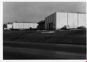
- Photograph of the exterior of Delnor Frozen Foods manufacturing facility, located at Winston Street and Bainbridge Avenue. The photograph is taken from across the road, facing north. The mountains are visible in the distance.
- Repository
- City of Burnaby Archives
- Date
- February 15, 1978
- Collection/Fonds
- Burnaby Public Library Contemporary Visual Archive Project
- Physical Description
- 1 photograph : b&w ; 12.5 x 17.5 cm
- Description Level
- Item
- Record No.
- 556-661
- Access Restriction
- No restrictions
- Reproduction Restriction
- Reproduce for fair dealing purposes only
- Accession Number
- 2017-57
- Scope and Content
- Photograph of the exterior of Delnor Frozen Foods manufacturing facility, located at Winston Street and Bainbridge Avenue. The photograph is taken from across the road, facing north. The mountains are visible in the distance.
- Subjects
- Buildings - Industrial - Factories
- Media Type
- Photograph
- Photographer
- Surridge, Jack
- Notes
- Title taken from project information form
- Accompanied by a project information form and 1 photograph (b&w negative ; 9.5 x 12.5 cm)
- BPL no. 109
- Geographic Access
- Winston Street
- Bainbridge Avenue
- Planning Study Area
- Government Road Area
Images
Dominion Bridge Company Limited - Burnaby Plant
https://search.heritageburnaby.ca/link/museumdescription17538
- Repository
- Burnaby Village Museum
- Date
- 29 Aug. 1957
- Collection/Fonds
- Burnaby Village Museum Map collection
- Description Level
- Item
- Physical Description
- 1 plan : col. lithographic print ; 50.5 x 84 cm
- Scope and Content
- Item consists of a fire insurance plan of the Dominion Bridge Company Burnaby Plant located on the east side of Boundary Road near Lougheed Highway. The plan is in two sheets mounted on a backing board. The buildings are located and colour coded. The plan includes profiles of the buildings. Title o…
- Repository
- Burnaby Village Museum
- Collection/Fonds
- Burnaby Village Museum Map collection
- Description Level
- Item
- Physical Description
- 1 plan : col. lithographic print ; 50.5 x 84 cm
- Material Details
- Scale [1:960]
- Scope and Content
- Item consists of a fire insurance plan of the Dominion Bridge Company Burnaby Plant located on the east side of Boundary Road near Lougheed Highway. The plan is in two sheets mounted on a backing board. The buildings are located and colour coded. The plan includes profiles of the buildings. Title on plan reads "DOMINION BRIDGE COMPANY, LIMITED / "BURNABY PLANT" / Burnaby, B.C.". The site plan was surveyed by C. L. Schwaab Jr.
- History
- Dominion Bridge Company was a major enterprise in Burnaby operating from the 1930 until the mid 1970s. Dominion Bridge constructed steel structures ranging from portions of the Golden Gate and Lions Gate Bridges to holding tanks for pulp mills. Beginning in the mid-1970s, unused areas of the site were used for filming on a temporary basis and in 1987 the site was established as a dedicated studio production facility named Bridge Studios.
- Creator
- Schwabb, C.L. Jr.
- Subjects
- Buildings - Industrial - Factories
- Names
- Dominion Bridge Company
- Responsibility
- Associated Factory Mutual Fire Insurance Cos
- Geographic Access
- Boundary Road
- Street Address
- 2400 Boundary Road
- Accession Code
- BV015.10.1
- Access Restriction
- Restricted access
- Reproduction Restriction
- May be restricted by third party rights
- Date
- 29 Aug. 1957
- Media Type
- Cartographic Material
- Historic Neighbourhood
- Broadview (Historic Neighbourhood)
- Planning Study Area
- West Central Valley Area
- Scan Resolution
- 400
- Scan Date
- 2021-11-28
- Notes
- Title based on contents of plan
- Scale on plan reads "1 inch = 80 ft / By V. Pitkin"
- Identfication information in bottom right corner of plan reads: "FACTORY MUTUAL ENGINEERING DIVISION / Associated Factory Mutual Fire Insurance Cos. / Norwood, Mass. / SERIAl 47330 / Replacing 35238 / INDEX 3994"
![Dugland C. Patterson Sr. beside his boiler, [1903 or 1904] thumbnail](/media/hpo/_Data/_Archives_Images/_Unrestricted/316/322-001.jpg?width=280)
Dugland C. Patterson Sr. beside his boiler
https://search.heritageburnaby.ca/link/archivedescription37116
- Repository
- City of Burnaby Archives
- Date
- [1903 or 1904]
- Collection/Fonds
- Burnaby Historical Society fonds
- Description Level
- Item
- Physical Description
- 1 photograph : sepia ; 10.5 x 8 cm, mounted on board 14 x 11 cm
- Scope and Content
- Photograph of Dugland Campbell Patterson Sr. standing by boiler he built; it was the largest built in New Westminster. He founded Vulcan Iron Works of New Westminister in 1903.
- Repository
- City of Burnaby Archives
- Date
- [1903 or 1904]
- Collection/Fonds
- Burnaby Historical Society fonds
- Subseries
- Patterson family subseries
- Physical Description
- 1 photograph : sepia ; 10.5 x 8 cm, mounted on board 14 x 11 cm
- Description Level
- Item
- Record No.
- 322-001
- Access Restriction
- No restrictions
- Reproduction Restriction
- No known restrictions
- Accession Number
- BHS1995-16
- Scope and Content
- Photograph of Dugland Campbell Patterson Sr. standing by boiler he built; it was the largest built in New Westminster. He founded Vulcan Iron Works of New Westminister in 1903.
- Subjects
- Buildings - Industrial - Factories
- Media Type
- Photograph
- Notes
- Title based on contents of photograph
- Note written by D.C. Patterson Jr. accompanying
Images
![Dugland C. Patterson Sr. beside his boiler, [1903 or 1904] thumbnail](/media/hpo/_Data/_Archives_Images/_Unrestricted/316/322-001.jpg)

Early maps of Burnaby
https://search.heritageburnaby.ca/link/archivedescription36450
- Repository
- City of Burnaby Archives
- Date
- 1990
- Collection/Fonds
- Burnaby Historical Society fonds
- Description Level
- Item
- Physical Description
- 1 photograph : col. ; 15 x 10 cm
- Scope and Content
- Photograph of a display that included early maps of the Burnaby area as part of the opening of the Burnaby Community Archives at the Burnaby Village Museum.
- Repository
- City of Burnaby Archives
- Date
- 1990
- Collection/Fonds
- Burnaby Historical Society fonds
- Subseries
- Donald N. Brown subseries
- Physical Description
- 1 photograph : col. ; 15 x 10 cm
- Description Level
- Item
- Record No.
- 271-018
- Access Restriction
- No restrictions
- Reproduction Restriction
- Reproduce for fair dealing purposes only
- Accession Number
- BHS1991-41
- Scope and Content
- Photograph of a display that included early maps of the Burnaby area as part of the opening of the Burnaby Community Archives at the Burnaby Village Museum.
- Subjects
- Documentary Artifacts - Maps
- Media Type
- Photograph
- Notes
- Title based on contents of photograph
- 1 photograph : col. negative ; 35 mm accompanying
- Geographic Access
- Deer Lake Avenue
- Street Address
- 6501 Deer Lake Avenue
- Historic Neighbourhood
- Burnaby Lake (Historic Neighbourhood)
- Planning Study Area
- Morley-Buckingham Area
Images

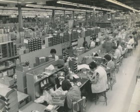
Interior of Lenkurt Electric Company
https://search.heritageburnaby.ca/link/archivedescription45616
- Repository
- City of Burnaby Archives
- Date
- November 1976, published November 17, 1976
- Collection/Fonds
- Columbian Newspaper collection
- Description Level
- Item
- Physical Description
- 1 photograph : b&w ; 19.5 x 24.5 cm
- Scope and Content
- Photograph of the interior of Lenkurt Electric's main manufacturing plant on the Lougheed Highway in Burnaby. Workers are at their desks, with their heads down, busily working. At the time of this photograph; "...1,400 employees make it one of the top secondary industries in B.C".
- Repository
- City of Burnaby Archives
- Date
- November 1976, published November 17, 1976
- Collection/Fonds
- Columbian Newspaper collection
- Physical Description
- 1 photograph : b&w ; 19.5 x 24.5 cm
- Description Level
- Item
- Record No.
- 480-510
- Access Restriction
- No restrictions
- Reproduction Restriction
- Reproduce for fair dealing purposes only
- Accession Number
- 2003-02
- Scope and Content
- Photograph of the interior of Lenkurt Electric's main manufacturing plant on the Lougheed Highway in Burnaby. Workers are at their desks, with their heads down, busily working. At the time of this photograph; "...1,400 employees make it one of the top secondary industries in B.C".
- Subjects
- Buildings - Industrial - Factories
- Names
- Lenkurt Electric Company
- Media Type
- Photograph
- Notes
- Title based on contents of photograph
- Newspaper clipping attached to verso of photograph reads: "Unit production at Lenkurt Electric's head office, research and development facility and main manufacturing plant on the Lougheed Highway in Burnaby is carried out on a semi-production basis, with a number of selected components mounted at each station. A total of 1,400 employees make it one of the top secondary industries in B.C."
- Geographic Access
- Lougheed Highway
- Street Address
- 7018 Lougheed Highway
- Historic Neighbourhood
- Lozells (Historic Neighbourhood)
- Planning Study Area
- Government Road Area
Images

![Link-Belt Factory, [1955] thumbnail](/media/hpo/_Data/_Archives_Images/_Unrestricted/001/074-001.jpg?width=280)
Link-Belt Factory
https://search.heritageburnaby.ca/link/archivedescription34639
- Repository
- City of Burnaby Archives
- Date
- [1955]
- Collection/Fonds
- Burnaby Historical Society fonds
- Description Level
- Item
- Physical Description
- 1 photograph : b&w ; 20.4 x 25.7 cm
- Scope and Content
- Photograph of the exterior of the Link-Belt factory at 2550 Boundary Road.
- Repository
- City of Burnaby Archives
- Date
- [1955]
- Collection/Fonds
- Burnaby Historical Society fonds
- Subseries
- Photographs subseries
- Physical Description
- 1 photograph : b&w ; 20.4 x 25.7 cm
- Description Level
- Item
- Record No.
- 074-001
- Access Restriction
- No restrictions
- Reproduction Restriction
- Reproduce for fair dealing purposes only
- Accession Number
- BHS2007-04
- Scope and Content
- Photograph of the exterior of the Link-Belt factory at 2550 Boundary Road.
- Subjects
- Buildings - Industrial - Factories
- Names
- Link-Belt Limited
- Media Type
- Photograph
- Notes
- Title based on contents of photograph
- Geographic Access
- Boundary Road
- Street Address
- 2550 Boundary Road
- Historic Neighbourhood
- Broadview (Historic Neighbourhood)
- Planning Study Area
- West Central Valley Area
Images
![Link-Belt Factory, [1955] thumbnail](/media/hpo/_Data/_Archives_Images/_Unrestricted/001/074-001.jpg)
![Link-Belt Factory, [1955] thumbnail](/media/hpo/_Data/_Archives_Images/_Unrestricted/001/074-002.jpg?width=280)
Link-Belt Factory
https://search.heritageburnaby.ca/link/archivedescription34640
- Repository
- City of Burnaby Archives
- Date
- [1955]
- Collection/Fonds
- Burnaby Historical Society fonds
- Description Level
- Item
- Physical Description
- 1 photograph : b&w ; 25.6 x 20.4 cm
- Scope and Content
- Photograph of the exterior of the Link-Belt factory at 2550 Boundary Road.
- Repository
- City of Burnaby Archives
- Date
- [1955]
- Collection/Fonds
- Burnaby Historical Society fonds
- Subseries
- Photographs subseries
- Physical Description
- 1 photograph : b&w ; 25.6 x 20.4 cm
- Description Level
- Item
- Record No.
- 074-002
- Access Restriction
- No restrictions
- Reproduction Restriction
- Reproduce for fair dealing purposes only
- Accession Number
- BHS2007-04
- Scope and Content
- Photograph of the exterior of the Link-Belt factory at 2550 Boundary Road.
- Subjects
- Buildings - Industrial - Factories
- Names
- Link-Belt Limited
- Media Type
- Photograph
- Notes
- Title based on contents of photograph
- Geographic Access
- Boundary Road
- Street Address
- 2550 Boundary Road
- Historic Neighbourhood
- Broadview (Historic Neighbourhood)
- Planning Study Area
- West Central Valley Area
Images
![Link-Belt Factory, [1955] thumbnail](/media/hpo/_Data/_Archives_Images/_Unrestricted/001/074-002.jpg)
![Mainland Clay Brick Plant, [194-] (date of original), copied 1991 thumbnail](/media/hpo/_Data/_Archives_Images/_Unrestricted/370/370-009.jpg?width=280)
Mainland Clay Brick Plant
https://search.heritageburnaby.ca/link/archivedescription37421
- Repository
- City of Burnaby Archives
- Date
- [194-] (date of original), copied 1991
- Collection/Fonds
- Burnaby Historical Society fonds
- Description Level
- Item
- Physical Description
- 1 photograph : b&w ; 3.3 x 5.4 cm print on contact sheet 20.2 x 25.4 cm
- Scope and Content
- Photograph of the exterior of Mainland Clay Brick Plant. Clay was discovered after William "Bill" Kask, Sr., shaved off the top of a hill for aesthetic reasons.
- Repository
- City of Burnaby Archives
- Date
- [194-] (date of original), copied 1991
- Collection/Fonds
- Burnaby Historical Society fonds
- Subseries
- Burnaby Image Bank subseries
- Physical Description
- 1 photograph : b&w ; 3.3 x 5.4 cm print on contact sheet 20.2 x 25.4 cm
- Description Level
- Item
- Record No.
- 370-009
- Access Restriction
- No restrictions
- Reproduction Restriction
- Reproduce for fair dealing purposes only
- Accession Number
- BHS1999-03
- Scope and Content
- Photograph of the exterior of Mainland Clay Brick Plant. Clay was discovered after William "Bill" Kask, Sr., shaved off the top of a hill for aesthetic reasons.
- Subjects
- Buildings - Industrial - Factories
- Media Type
- Photograph
- Notes
- Title based on contents of photograph
- 1 b&w copy negative accompanying
- Geographic Access
- Barnet Road
- Historic Neighbourhood
- Barnet (Historic Neighbourhood)
- Planning Study Area
- Burnaby Mountain Area
Images
![Mainland Clay Brick Plant, [194-] (date of original), copied 1991 thumbnail](/media/hpo/_Data/_Archives_Images/_Unrestricted/370/370-009.jpg)
![Map of Burnaby, [1971] thumbnail](/media/hpo/_Data/_BVM_Images/2005/2005_0054_0237_001.jpg?width=280)
Map of Burnaby
https://search.heritageburnaby.ca/link/museumdescription2189
- Repository
- Burnaby Village Museum
- Date
- [1971]
- Collection/Fonds
- Donald Copan collection
- Description Level
- Item
- Physical Description
- 1 photograph : b&w ; 8.9 x 12.7 cm
- Scope and Content
- Photograph of large sign with map of Burnaby. Map was used for Burnaby Centennial Celebrations display in 1971.
- Repository
- Burnaby Village Museum
- Collection/Fonds
- Donald Copan collection
- Series
- Copan album series
- Description Level
- Item
- Physical Description
- 1 photograph : b&w ; 8.9 x 12.7 cm
- Scope and Content
- Photograph of large sign with map of Burnaby. Map was used for Burnaby Centennial Celebrations display in 1971.
- Accession Code
- BV005.54.237
- Access Restriction
- No restrictions
- Reproduction Restriction
- May be restricted by third party rights
- Date
- [1971]
- Media Type
- Photograph
- Scan Resolution
- 600
- Scan Date
- July 21, 2020
- Scale
- 100
- Notes
- Title based on contents of photograph
Images
![Map of Burnaby, [1971] thumbnail](/media/hpo/_Data/_BVM_Images/2005/2005_0054_0237_001.jpg)
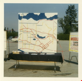
Map of Burnaby
https://search.heritageburnaby.ca/link/museumdescription13259
- Repository
- Burnaby Village Museum
- Date
- 1971
- Collection/Fonds
- Donald Copan collection
- Description Level
- Item
- Physical Description
- 1 photograph : col. ; 8.9 x 8.9 cm
- Scope and Content
- Photograph of a large map of Burnaby displayed on a table in a parking lot. A poster for "Middlegate" Shopping Centre is displayed to the right.
- Repository
- Burnaby Village Museum
- Collection/Fonds
- Donald Copan collection
- Series
- Copan album series
- Description Level
- Item
- Physical Description
- 1 photograph : col. ; 8.9 x 8.9 cm
- Scope and Content
- Photograph of a large map of Burnaby displayed on a table in a parking lot. A poster for "Middlegate" Shopping Centre is displayed to the right.
- Accession Code
- BV005.54.273
- Access Restriction
- No restrictions
- Reproduction Restriction
- May be restricted by third party rights
- Date
- 1971
- Media Type
- Photograph
- Scan Resolution
- 600
- Scan Date
- July 23, 2020
- Scale
- 100
- Notes
- Title based on contents of photograph
Images
