Narrow Results By
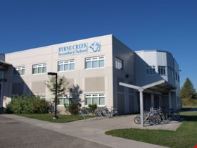
Byrne Creek Secondary School
https://search.heritageburnaby.ca/link/landmark849
- Repository
- Burnaby Heritage Planning
- Geographic Access
- 18th Street
- Associated Dates
- 2005
- Heritage Value
- Byrne Creek School opened in 2005 and accommodates students from grades 8 through 12. When built, the school was created to house as many as 1200 students, but by 2009, plans have been prepared to increase that capacity to 1500.
- Historic Neighbourhood
- Edmonds (Historic Neighbourhood)
- Planning Study Area
- Stride Avenue Area
- Street Address
- 7777 18th Street
- Street View URL
- Google Maps Street View
Images
Schou Street School site
https://search.heritageburnaby.ca/link/museumdescription11138
- Repository
- Burnaby Village Museum
- Date
- April 12, 1915
- Collection/Fonds
- Ronald G. Scobbie collection
- Description Level
- Item
- Physical Description
- 1 survey plan : blueprint on paper ; 56 x 54 cm
- Scope and Content
- Survey plan of "Schou Street School Site / Burnaby Municipality" "Being Lot 1-12 inc. of Block 47, of subd. of Blocks 8-12 and 15-49 inclusive, Lot 69, Group 1" "New Westminster District";
- Repository
- Burnaby Village Museum
- Collection/Fonds
- Ronald G. Scobbie collection
- Description Level
- Item
- Physical Description
- 1 survey plan : blueprint on paper ; 56 x 54 cm
- Material Details
- Scale 40 feet = 1 inch
- Scope and Content
- Survey plan of "Schou Street School Site / Burnaby Municipality" "Being Lot 1-12 inc. of Block 47, of subd. of Blocks 8-12 and 15-49 inclusive, Lot 69, Group 1" "New Westminster District";
- Creator
- Burnett, Geoffrey K.
- Subjects
- Buildings - Schools
- Names
- Schou Street School
- Responsibility
- Burnett & McGugan, Engineers and Surveyors
- Geographic Access
- Canada Way
- Grandview Highway
- Gilmore Avenue
- Street Address
- 4054 Norfolk Street
- Accession Code
- BV003.83.17
- Access Restriction
- No restrictions
- Reproduction Restriction
- No known restrictions
- Date
- April 12, 1915
- Media Type
- Cartographic Material
- Historic Neighbourhood
- Broadview (Historic Neighbourhood)
- Planning Study Area
- Cascade-Schou Area
- Scan Resolution
- 440
- Scan Date
- 22-Dec-2020
- Scale
- 100
- Notes
- Title based on contents of plan
- Oath on plan reads: "I, Geoffrey K. Burnett...did person- ally superintend the survey..." "...completed on the 12th day of April 1915"; signed by Geoffrey K. Burnett, notarized by "S.F. Mark", sworn "..12th day.. April 1915" "Burnett and McGugan" "B.C. Land Surveyors Etc. New Westminster, B.C.
- ."handwritten on back, "1751"
- two school buildings are shown on this blueprint, "Old School Building", "New School Building"

