Narrow Results By
Subject
- Advertising Medium - Signs and Signboards 2
- Agriculture - Farms 1
- Buildings - Agricultural - Barns 1
- Buildings - Civic - Libraries 1
- Buildings - Commercial 1
- Buildings - Commercial - General Stores 4
- Buildings - Commercial - Hardware Stores 17
- Buildings - Commercial - Restaurants 1
- Buildings - Commercial - Train Stations 1
- Buildings - Heritage 17
- Buildings - Industrial - Factories 5
- Buildings - Recreational 4

Our Lady of Mercy Church Manse
https://search.heritageburnaby.ca/link/archivedescription35075
- Repository
- City of Burnaby Archives
- Date
- October 21, 1986
- Collection/Fonds
- Burnaby Historical Society fonds
- Description Level
- Item
- Physical Description
- 1 photograph : b&w ; 8.8 x 12.6 cm
- Scope and Content
- Photograph of the exterior of the manse at Our Lady of Mercy Catholic Church, 7455 10th Avenue and Kingsway. The photo was taken before the manse was demolished. An automobile is parked outside.
- Repository
- City of Burnaby Archives
- Date
- October 21, 1986
- Collection/Fonds
- Burnaby Historical Society fonds
- Subseries
- Jim Wolf subseries
- Physical Description
- 1 photograph : b&w ; 8.8 x 12.6 cm
- Description Level
- Item
- Record No.
- 188-002
- Access Restriction
- No restrictions
- Reproduction Restriction
- Reproduce for fair dealing purposes only
- Accession Number
- BHS1986-39
- Scope and Content
- Photograph of the exterior of the manse at Our Lady of Mercy Catholic Church, 7455 10th Avenue and Kingsway. The photo was taken before the manse was demolished. An automobile is parked outside.
- Subjects
- Buildings - Religious - Churches
- Names
- Our Lady of Mercy Church
- Media Type
- Photograph
- Photographer
- Wolf, Jim
- Notes
- Title based on contents of photograph
- Geographic Access
- 10th Avenue
- Street Address
- 7455 10th Avenue
- Historic Neighbourhood
- Edmonds (Historic Neighbourhood)
- Planning Study Area
- Edmonds Area
Images


Our Lady of Mercy Church Manse
https://search.heritageburnaby.ca/link/archivedescription35076
- Repository
- City of Burnaby Archives
- Date
- October 21, 1986
- Collection/Fonds
- Burnaby Historical Society fonds
- Description Level
- Item
- Physical Description
- 1 photograph : b&w ; 8.8 x 12.4 cm
- Scope and Content
- Photograph of the exterior of the manse at Our Lady of Mercy Catholic Church, 7455 10th Avenue and Kingsway. The photo was taken before the manse was demolished.
- Repository
- City of Burnaby Archives
- Date
- October 21, 1986
- Collection/Fonds
- Burnaby Historical Society fonds
- Subseries
- Jim Wolf subseries
- Physical Description
- 1 photograph : b&w ; 8.8 x 12.4 cm
- Description Level
- Item
- Record No.
- 188-003
- Access Restriction
- No restrictions
- Reproduction Restriction
- Reproduce for fair dealing purposes only
- Accession Number
- BHS1986-39
- Scope and Content
- Photograph of the exterior of the manse at Our Lady of Mercy Catholic Church, 7455 10th Avenue and Kingsway. The photo was taken before the manse was demolished.
- Subjects
- Buildings - Religious - Churches
- Names
- Our Lady of Mercy Church
- Media Type
- Photograph
- Photographer
- Wolf, Jim
- Notes
- Title based on contents of photograph
- Geographic Access
- 10th Avenue
- Street Address
- 7455 10th Avenue
- Historic Neighbourhood
- Edmonds (Historic Neighbourhood)
- Planning Study Area
- Edmonds Area
Images


Our Lady of Mercy Church Manse
https://search.heritageburnaby.ca/link/archivedescription35077
- Repository
- City of Burnaby Archives
- Date
- October 21, 1986
- Collection/Fonds
- Burnaby Historical Society fonds
- Description Level
- Item
- Physical Description
- 1 photograph : b&w ; 8.8 x 12.6 cm
- Scope and Content
- Photograph of the exterior of the manse at Our Lady of Mercy Catholic Church, 7455 10th Avenue and Kingsway. The photo was taken before the manse was demolished.
- Repository
- City of Burnaby Archives
- Date
- October 21, 1986
- Collection/Fonds
- Burnaby Historical Society fonds
- Subseries
- Jim Wolf subseries
- Physical Description
- 1 photograph : b&w ; 8.8 x 12.6 cm
- Description Level
- Item
- Record No.
- 188-004
- Access Restriction
- No restrictions
- Reproduction Restriction
- Reproduce for fair dealing purposes only
- Accession Number
- BHS1986-39
- Scope and Content
- Photograph of the exterior of the manse at Our Lady of Mercy Catholic Church, 7455 10th Avenue and Kingsway. The photo was taken before the manse was demolished.
- Subjects
- Buildings - Religious - Churches
- Names
- Our Lady of Mercy Church
- Media Type
- Photograph
- Photographer
- Wolf, Jim
- Notes
- Title based on contents of photograph
- Geographic Access
- 10th Avenue
- Street Address
- 7455 10th Avenue
- Historic Neighbourhood
- Edmonds (Historic Neighbourhood)
- Planning Study Area
- Edmonds Area
Images


Our Lady of Mercy Church Manse
https://search.heritageburnaby.ca/link/archivedescription35078
- Repository
- City of Burnaby Archives
- Date
- October 21, 1986
- Collection/Fonds
- Burnaby Historical Society fonds
- Description Level
- Item
- Physical Description
- 1 photograph : b&w ; 8.8 x 12.4 cm
- Scope and Content
- Photograph of the exterior of the manse at Our Lady of Mercy Catholic Church, 7455 10th Avenue and Kingsway. The photo was taken before the manse was demolished. The church is at the left side of the photo, and the manse is at the right side.
- Repository
- City of Burnaby Archives
- Date
- October 21, 1986
- Collection/Fonds
- Burnaby Historical Society fonds
- Subseries
- Jim Wolf subseries
- Physical Description
- 1 photograph : b&w ; 8.8 x 12.4 cm
- Description Level
- Item
- Record No.
- 188-005
- Access Restriction
- No restrictions
- Reproduction Restriction
- Reproduce for fair dealing purposes only
- Accession Number
- BHS1986-39
- Scope and Content
- Photograph of the exterior of the manse at Our Lady of Mercy Catholic Church, 7455 10th Avenue and Kingsway. The photo was taken before the manse was demolished. The church is at the left side of the photo, and the manse is at the right side.
- Subjects
- Buildings - Religious - Churches
- Names
- Our Lady of Mercy Church
- Media Type
- Photograph
- Photographer
- Wolf, Jim
- Notes
- Title based on contents of photograph
- Geographic Access
- 10th Avenue
- Street Address
- 7455 10th Avenue
- Historic Neighbourhood
- Edmonds (Historic Neighbourhood)
- Planning Study Area
- Edmonds Area
Images


Our Lady of Mercy Church Manse
https://search.heritageburnaby.ca/link/archivedescription35079
- Repository
- City of Burnaby Archives
- Date
- October 21, 1986
- Collection/Fonds
- Burnaby Historical Society fonds
- Description Level
- Item
- Physical Description
- 1 photograph : b&w ; 8.8 x 12.5 cm
- Scope and Content
- Photograph of the exterior of the manse at Our Lady of Mercy Catholic Church, 7455 10th Avenue and Kingsway. The photo was taken before the manse was demolished. The church is at the left side of the photo, and the manse is at the right side.
- Repository
- City of Burnaby Archives
- Date
- October 21, 1986
- Collection/Fonds
- Burnaby Historical Society fonds
- Subseries
- Jim Wolf subseries
- Physical Description
- 1 photograph : b&w ; 8.8 x 12.5 cm
- Description Level
- Item
- Record No.
- 188-006
- Access Restriction
- No restrictions
- Reproduction Restriction
- Reproduce for fair dealing purposes only
- Accession Number
- BHS1986-39
- Scope and Content
- Photograph of the exterior of the manse at Our Lady of Mercy Catholic Church, 7455 10th Avenue and Kingsway. The photo was taken before the manse was demolished. The church is at the left side of the photo, and the manse is at the right side.
- Subjects
- Buildings - Religious - Churches
- Names
- Our Lady of Mercy Church
- Media Type
- Photograph
- Photographer
- Wolf, Jim
- Notes
- Title based on contents of photograph
- Geographic Access
- 10th Avenue
- Street Address
- 7455 10th Avenue
- Historic Neighbourhood
- Edmonds (Historic Neighbourhood)
- Planning Study Area
- Edmonds Area
Images


Our Lady of Mercy Rectory
https://search.heritageburnaby.ca/link/archivedescription79044
- Repository
- City of Burnaby Archives
- Date
- September 10, 1976
- Collection/Fonds
- Burnaby Public Library Contemporary Visual Archive Project
- Description Level
- Item
- Physical Description
- 1 photograph : b&w ; 11 x 16 cm mounted on cardboard
- Scope and Content
- Photograph shows the Our Lady of Mercy Rectory located at 7892 Kingsway (later 7455 10th Avenue).
- Repository
- City of Burnaby Archives
- Date
- September 10, 1976
- Collection/Fonds
- Burnaby Public Library Contemporary Visual Archive Project
- Physical Description
- 1 photograph : b&w ; 11 x 16 cm mounted on cardboard
- Description Level
- Item
- Record No.
- 556-111
- Access Restriction
- No restrictions
- Reproduction Restriction
- Reproduce for fair dealing purposes only
- Accession Number
- 2013-13
- Scope and Content
- Photograph shows the Our Lady of Mercy Rectory located at 7892 Kingsway (later 7455 10th Avenue).
- Subjects
- Buildings - Religious - Churches
- Names
- Our Lady of Mercy Church
- Media Type
- Photograph
- Photographer
- Ross, Martha
- Notes
- Scope note taken directly from BPL photograph description.
- 1 b&w copy negative : 10 x 12.5 cm accompanying
- Geographic Access
- Kingsway
- 10th Avenue
- Street Address
- 7892 Kingsway
- 7455 10th Avenue
- Historic Neighbourhood
- Edmonds (Historic Neighbourhood)
- Planning Study Area
- Edmonds Area
Images


Parish Church of Our Lady of Mercy
https://search.heritageburnaby.ca/link/archivedescription79043
- Repository
- City of Burnaby Archives
- Date
- September 16, 1976
- Collection/Fonds
- Burnaby Public Library Contemporary Visual Archive Project
- Description Level
- Item
- Physical Description
- 1 photograph : b&w ; 11 x 16 cm mounted on cardboard
- Scope and Content
- Photograph shows the Parish Church of Our Lady of Mercy located at 7892 Kingsway (later 7455 10th Avenue). Construction of this church was held up by World War II but it was completed in 1944.
- Repository
- City of Burnaby Archives
- Date
- September 16, 1976
- Collection/Fonds
- Burnaby Public Library Contemporary Visual Archive Project
- Physical Description
- 1 photograph : b&w ; 11 x 16 cm mounted on cardboard
- Description Level
- Item
- Record No.
- 556-110
- Access Restriction
- No restrictions
- Reproduction Restriction
- Reproduce for fair dealing purposes only
- Accession Number
- 2013-13
- Scope and Content
- Photograph shows the Parish Church of Our Lady of Mercy located at 7892 Kingsway (later 7455 10th Avenue). Construction of this church was held up by World War II but it was completed in 1944.
- Subjects
- Buildings - Religious - Churches
- Names
- Our Lady of Mercy Church
- Media Type
- Photograph
- Photographer
- Born, A. J.
- Notes
- Scope note taken directly from BPL photograph description.
- 1 b&w copy negative : 10 x 12.5 cm accompanying
- Geographic Access
- Kingsway
- 10th Avenue
- Street Address
- 7892 Kingsway
- 7455 10th Avenue
- Historic Neighbourhood
- Edmonds (Historic Neighbourhood)
- Planning Study Area
- Edmonds Area
Images

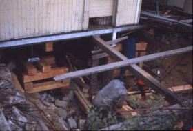
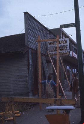
Placing timbers under Whitechurch Hardware
https://search.heritageburnaby.ca/link/museumdescription16887
- Repository
- Burnaby Village Museum
- Date
- Aug. 1974
- Collection/Fonds
- Burnaby Village Museum fonds
- Description Level
- Item
- Physical Description
- 1 photograph : col. slide ; 35 mm
- Scope and Content
- Photograph of two people placing timbers and supports under the Whitechurch Hardware building in preparation to be moved by the Nickel Brothers house moving company from 7685 Sixth Street to Heritage Village (Burnaby Village Museum).
- Repository
- Burnaby Village Museum
- Collection/Fonds
- Burnaby Village Museum fonds
- Subseries
- Bell's building photographs subseries
- Description Level
- Item
- Physical Description
- 1 photograph : col. slide ; 35 mm
- Scope and Content
- Photograph of two people placing timbers and supports under the Whitechurch Hardware building in preparation to be moved by the Nickel Brothers house moving company from 7685 Sixth Street to Heritage Village (Burnaby Village Museum).
- Geographic Access
- 6th Street
- Street Address
- 7695 6th Street
- 7685 6th Street
- Accession Code
- BV020.5.1857
- Access Restriction
- No restrictions
- Reproduction Restriction
- No known restrictions
- Date
- Aug. 1974
- Media Type
- Photograph
- Historic Neighbourhood
- East Burnaby (Historic Neighbourhood)
- Planning Study Area
- Second Street Area
- Scan Resolution
- 2400
- Scale
- 100
- Notes
- Title based on contents of photograph
- Note in blue ink on slide frame reads: "(FRONT) / VIEW FROM THIS SIDE / WRONG SIDE / Whitechurch Hardware / Puttin in timbers"
- 1 col. copy print accompanying
Images

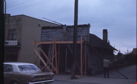
Removal of false front from Whitechurch Hardware
https://search.heritageburnaby.ca/link/museumdescription16898
- Repository
- Burnaby Village Museum
- Date
- Aug. 1974
- Collection/Fonds
- Burnaby Village Museum fonds
- Description Level
- Item
- Physical Description
- 1 photograph : col. slide ; 35 mm
- Scope and Content
- Photograph of Angelo Otten and an unidentified man removing the false front from the Whitechurch Hardware building located at 7685 Sixth Street. Angelo Otten is standing on wooden scaffolding in front of the store. A two storey building with convenience store at ground level is visible to the left …
- Repository
- Burnaby Village Museum
- Collection/Fonds
- Burnaby Village Museum fonds
- Subseries
- Bell's building photographs subseries
- Description Level
- Item
- Physical Description
- 1 photograph : col. slide ; 35 mm
- Scope and Content
- Photograph of Angelo Otten and an unidentified man removing the false front from the Whitechurch Hardware building located at 7685 Sixth Street. Angelo Otten is standing on wooden scaffolding in front of the store. A two storey building with convenience store at ground level is visible to the left (7695 Sixth Street).
- Geographic Access
- 6th Street
- Street Address
- 7695 6th Street
- 7685 6th Street
- Accession Code
- BV020.5.1868
- Access Restriction
- No restrictions
- Reproduction Restriction
- No known restrictions
- Date
- Aug. 1974
- Media Type
- Photograph
- Historic Neighbourhood
- East Burnaby (Historic Neighbourhood)
- Planning Study Area
- Second Street Area
- Scan Resolution
- 2400
- Scale
- 100
- Notes
- Title based on contents of photograph
- Note in blue ink on slide frame reads: "Angelo + co. taking / off false front / Whitechurch Aug / 74"
Images
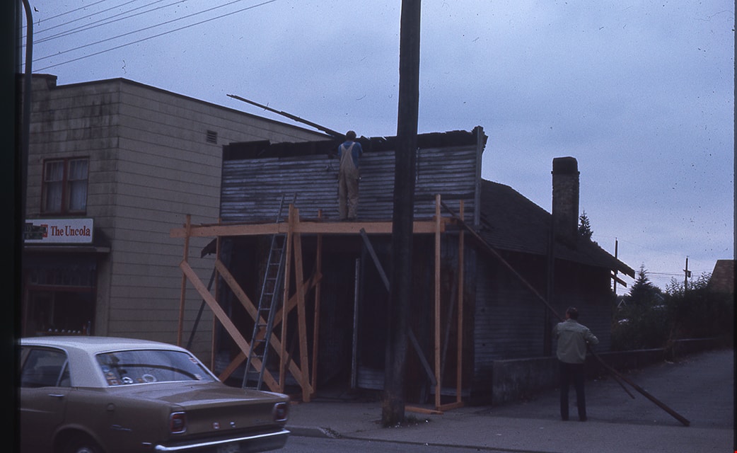
Removing false front from Whitechurch Hardware building
https://search.heritageburnaby.ca/link/museumdescription16892
- Repository
- Burnaby Village Museum
- Date
- Aug. 1974
- Collection/Fonds
- Burnaby Village Museum fonds
- Description Level
- Item
- Physical Description
- 1 photograph : col. slide ; 35 mm
- Scope and Content
- Photograph of Angelo Otten and Peter Otten removing the false front from the Whitechurch Hardware building during preparation for the building to be moved from it's location at 7685 Sixth Street to Heritage Village (Burnaby Village Museum). The Whitechurch Hardware sign is hanging from the from the…
- Repository
- Burnaby Village Museum
- Collection/Fonds
- Burnaby Village Museum fonds
- Subseries
- Bell's building photographs subseries
- Description Level
- Item
- Physical Description
- 1 photograph : col. slide ; 35 mm
- Scope and Content
- Photograph of Angelo Otten and Peter Otten removing the false front from the Whitechurch Hardware building during preparation for the building to be moved from it's location at 7685 Sixth Street to Heritage Village (Burnaby Village Museum). The Whitechurch Hardware sign is hanging from the from the false front. Street sign reading "13th Ave / 7800" is attached to a pole and visible in the foreground.
- Geographic Access
- 6th Street
- Street Address
- 7695 6th Street
- 7685 6th Street
- Accession Code
- BV020.5.1862
- Access Restriction
- No restrictions
- Reproduction Restriction
- No known restrictions
- Date
- Aug. 1974
- Media Type
- Photograph
- Historic Neighbourhood
- East Burnaby (Historic Neighbourhood)
- Planning Study Area
- Second Street Area
- Scan Resolution
- 2400
- Scale
- 100
- Notes
- Title based on contents of photograph
- Note in blue ink on slide frame reads: "FRONT / Removing false / front of White- / church / Aug 74 / Angelo & Peter / Otten"
Images

![Robert Nasato at Marine/10th Ave. Connector, [2000] thumbnail](/media/hpo/_Data/_Archives_Images/_Unrestricted/535/535-3069.jpg?width=280)
Robert Nasato at Marine/10th Ave. Connector
https://search.heritageburnaby.ca/link/archivedescription97943
- Repository
- City of Burnaby Archives
- Date
- [2000]
- Collection/Fonds
- Burnaby NewsLeader photograph collection
- Description Level
- Item
- Physical Description
- 1 photograph (tiff) : col.
- Scope and Content
- Photograph of Robert Nasato, the president of the West End Residents' Association, posing net to sign advertising the plans for the Marine/10th Ave. Connector.
- Repository
- City of Burnaby Archives
- Date
- [2000]
- Collection/Fonds
- Burnaby NewsLeader photograph collection
- Physical Description
- 1 photograph (tiff) : col.
- Description Level
- Item
- Record No.
- 535-3069
- Access Restriction
- No restrictions
- Reproduction Restriction
- No restrictions
- Accession Number
- 2018-12
- Scope and Content
- Photograph of Robert Nasato, the president of the West End Residents' Association, posing net to sign advertising the plans for the Marine/10th Ave. Connector.
- Media Type
- Photograph
- Photographer
- Bartel, Mario
- Notes
- Title based on caption
- Collected by editorial for use in a January 2000 issue of the Burnaby NewsLeader
- Caption from metadata: "Robert Nasato, the president of the West End Residents' Association, isn't happy about the proposed Marine/10th Ave. connector, to be built through his neighborhood."
- Geographic Access
- 10th Avenue
- Marine Drive
- Historic Neighbourhood
- Fraser Arm (Historic Neighbourhood)
- Planning Study Area
- Stride Hill Area
Images
![Robert Nasato at Marine/10th Ave. Connector, [2000] thumbnail](/media/hpo/_Data/_Archives_Images/_Unrestricted/535/535-3069.jpg)

Running track at Saint Thomas More Collegiate
https://search.heritageburnaby.ca/link/archivedescription78788
- Repository
- City of Burnaby Archives
- Date
- 2001 (date of original); 2013 (date of annotation)
- Collection/Fonds
- Walker family fonds
- Description Level
- Item
- Physical Description
- 1 photograph (jpeg) : col. ; 300 dpi
- Scope and Content
- Photograph of the running track at Saint Thomas More Collegiate with Our Lady of Mercy Parish visible in the background.
- Repository
- City of Burnaby Archives
- Date
- 2001 (date of original); 2013 (date of annotation)
- Collection/Fonds
- Walker family fonds
- Physical Description
- 1 photograph (jpeg) : col. ; 300 dpi
- Description Level
- Item
- Record No.
- 557-038
- Access Restriction
- No restrictions
- Reproduction Restriction
- No known restrictions
- Accession Number
- 2013-15
- Scope and Content
- Photograph of the running track at Saint Thomas More Collegiate with Our Lady of Mercy Parish visible in the background.
- Subjects
- Buildings - Religious - Churches
- Media Type
- Photograph
- Notes
- Title based on contents of photograph
- Geographic Access
- 10th Avenue
- Historic Neighbourhood
- Edmonds (Historic Neighbourhood)
- Planning Study Area
- Edmonds Area
Images


Running track at Saint Thomas More Collegiate
https://search.heritageburnaby.ca/link/archivedescription78789
- Repository
- City of Burnaby Archives
- Date
- 2001 (date of original); 2013 (date of annotation)
- Collection/Fonds
- Walker family fonds
- Description Level
- Item
- Physical Description
- 1 photograph (jpeg) : col. ; 300 dpi
- Scope and Content
- Photograph of the running track at Saint Thomas More Collegiate with the school visible in the background.
- Repository
- City of Burnaby Archives
- Date
- 2001 (date of original); 2013 (date of annotation)
- Collection/Fonds
- Walker family fonds
- Physical Description
- 1 photograph (jpeg) : col. ; 300 dpi
- Description Level
- Item
- Record No.
- 557-039
- Access Restriction
- No restrictions
- Reproduction Restriction
- No known restrictions
- Accession Number
- 2013-15
- Scope and Content
- Photograph of the running track at Saint Thomas More Collegiate with the school visible in the background.
- Subjects
- Buildings - Schools
- Media Type
- Photograph
- Notes
- Title based on contents of photograph
- Geographic Access
- 10th Avenue
- Historic Neighbourhood
- Edmonds (Historic Neighbourhood)
- Planning Study Area
- Edmonds Area
Images


Running track at Saint Thomas More Collegiate
https://search.heritageburnaby.ca/link/archivedescription78790
- Repository
- City of Burnaby Archives
- Date
- 2001 (date of original); 2013 (date of annotation)
- Collection/Fonds
- Walker family fonds
- Description Level
- Item
- Physical Description
- 1 photograph (jpeg) : col. ; 96 dpi
- Scope and Content
- Photograph of the running track at Saint Thomas More Collegiate with the school visible in the background.
- Repository
- City of Burnaby Archives
- Date
- 2001 (date of original); 2013 (date of annotation)
- Collection/Fonds
- Walker family fonds
- Physical Description
- 1 photograph (jpeg) : col. ; 96 dpi
- Description Level
- Item
- Record No.
- 557-040
- Access Restriction
- No restrictions
- Reproduction Restriction
- No known restrictions
- Accession Number
- 2013-15
- Scope and Content
- Photograph of the running track at Saint Thomas More Collegiate with the school visible in the background.
- Subjects
- Buildings - Schools
- Media Type
- Photograph
- Notes
- Title based on contents of photograph
- Geographic Access
- 10th Avenue
- Historic Neighbourhood
- Edmonds (Historic Neighbourhood)
- Planning Study Area
- Edmonds Area
Images


Silvanovicz family
https://search.heritageburnaby.ca/link/archivedescription36850
- Repository
- City of Burnaby Archives
- Date
- 1934
- Collection/Fonds
- Burnaby Historical Society fonds
- Description Level
- Item
- Physical Description
- 1 photograph : b&w ; 9 x 13 cm print
- Scope and Content
- Photograph of the first Silvanovicz family home at 2109 Willard Street (old street numbering system). Members of the Sivanovicz family are in front, left to right: Helen (daughter), Mary (mother), and Alex (son).
- Repository
- City of Burnaby Archives
- Date
- 1934
- Collection/Fonds
- Burnaby Historical Society fonds
- Subseries
- Burnaby Centennial Anthology subseries
- Physical Description
- 1 photograph : b&w ; 9 x 13 cm print
- Description Level
- Item
- Record No.
- 315-308
- Access Restriction
- No restrictions
- Reproduction Restriction
- No known restrictions
- Accession Number
- BHS1994-04
- Scope and Content
- Photograph of the first Silvanovicz family home at 2109 Willard Street (old street numbering system). Members of the Sivanovicz family are in front, left to right: Helen (daughter), Mary (mother), and Alex (son).
- Media Type
- Photograph
- Notes
- Title based on contents of photograph
- Geographic Access
- Willard Street
- 12th Avenue
- 10th Avenue
- Historic Neighbourhood
- Fraser Arm (Historic Neighbourhood)
- Planning Study Area
- Big Bend Area
Images

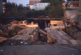
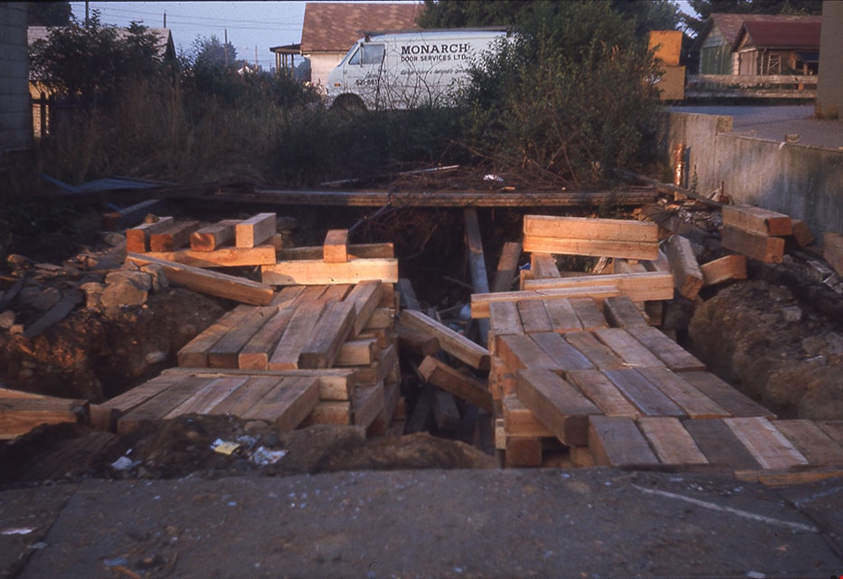
Site of former Whitechurch Hardware building
https://search.heritageburnaby.ca/link/museumdescription16903
- Repository
- Burnaby Village Museum
- Date
- Aug. 1974
- Collection/Fonds
- Burnaby Village Museum fonds
- Description Level
- Item
- Physical Description
- 1 photograph : col. slide ; 35 mm
- Scope and Content
- Photograph of timbers on the ground after the Whitechurch Hardware building was moved by Nickel Brothers house moving company from 7685 Sixth Street to Heritage Village (Burnaby Village Museum.
- Repository
- Burnaby Village Museum
- Collection/Fonds
- Burnaby Village Museum fonds
- Subseries
- Bell's building photographs subseries
- Description Level
- Item
- Physical Description
- 1 photograph : col. slide ; 35 mm
- Scope and Content
- Photograph of timbers on the ground after the Whitechurch Hardware building was moved by Nickel Brothers house moving company from 7685 Sixth Street to Heritage Village (Burnaby Village Museum.
- Geographic Access
- 6th Street
- Street Address
- 7685 6th Street
- Accession Code
- BV020.5.1873
- Access Restriction
- No restrictions
- Reproduction Restriction
- No known restrictions
- Date
- Aug. 1974
- Media Type
- Photograph
- Historic Neighbourhood
- East Burnaby (Historic Neighbourhood)
- Planning Study Area
- Second Street Area
- Scan Resolution
- 2400
- Scale
- 100
- Notes
- Title based on contents of photograph
- Note in blue ink on slide frame reads: "Timbers after / Whitechurch / removed from site"
Images
![Starlite Room fire, [2003] thumbnail](/media/hpo/_Data/_Archives_Images/_Unrestricted/535/535-2044.jpg?width=280)
Starlite Room fire
https://search.heritageburnaby.ca/link/archivedescription96363
- Repository
- City of Burnaby Archives
- Date
- [2003]
- Collection/Fonds
- Burnaby NewsLeader photograph collection
- Description Level
- Item
- Physical Description
- 1 photograph (tiff) : col.
- Scope and Content
- Photograph of two Burnaby fire fighters outside of the Starlite Room banquet hall after fighting a fire. One fire fighter is climbing down a ladder as the other holds it. The Starlite Room's sign is visible in the background.
- Repository
- City of Burnaby Archives
- Date
- [2003]
- Collection/Fonds
- Burnaby NewsLeader photograph collection
- Physical Description
- 1 photograph (tiff) : col.
- Description Level
- Item
- Record No.
- 535-2044
- Access Restriction
- No restrictions
- Reproduction Restriction
- No restrictions
- Accession Number
- 2018-12
- Scope and Content
- Photograph of two Burnaby fire fighters outside of the Starlite Room banquet hall after fighting a fire. One fire fighter is climbing down a ladder as the other holds it. The Starlite Room's sign is visible in the background.
- Names
- Burnaby Fire Department
- Media Type
- Photograph
- Photographer
- Bartel, Mario
- Notes
- Title based on caption
- Collected by editorial for use in a March 2003 issue of the Burnaby NewsLeader
- Caption from metadata: "Burnaby firefighters mop up after fire gutted the Starlite Room banquet hall, in the 7600 block of 6th St., early Saturday morning. The building's second floor was severly damaged by the fire, while other businesses on the ground floor received smoke and water damage. One person was slightly injured. The fire was the second of the night for Burnaby firefighters, who also battled a fire in a single-family home in the 5500 block of Donovan Ave., causing $280,000 damage. Nobody was home at the time."
- Geographic Access
- 6th Street
- Historic Neighbourhood
- Edmonds (Historic Neighbourhood)
- Planning Study Area
- Second Street Area
Images
![Starlite Room fire, [2003] thumbnail](/media/hpo/_Data/_Archives_Images/_Unrestricted/535/535-2044.jpg)
![Traffic in Lakeview-Edmonds, [2001] thumbnail](/media/hpo/_Data/_Archives_Images/_Unrestricted/535/535-2959-1.jpg?width=280)
Traffic in Lakeview-Edmonds
https://search.heritageburnaby.ca/link/archivedescription97676
- Repository
- City of Burnaby Archives
- Date
- [2001]
- Collection/Fonds
- Burnaby NewsLeader photograph collection
- Description Level
- File
- Physical Description
- 4 photographs (tiff) : col.
- Scope and Content
- File contains photographs related to transportation and traffic in the Edmonds area of Burnaby. Photographs depict Argus Carriers delivery driver Terry Doyle at work in his delivery truck, and Lidia Rossi, Porcellato, and Muriel Logan, all members of the Lakeview-Edmonds Neighbourhood Association, …
- Repository
- City of Burnaby Archives
- Date
- [2001]
- Collection/Fonds
- Burnaby NewsLeader photograph collection
- Physical Description
- 4 photographs (tiff) : col.
- Description Level
- File
- Record No.
- 535-2959
- Access Restriction
- No restrictions
- Reproduction Restriction
- No restrictions
- Accession Number
- 2018-12
- Scope and Content
- File contains photographs related to transportation and traffic in the Edmonds area of Burnaby. Photographs depict Argus Carriers delivery driver Terry Doyle at work in his delivery truck, and Lidia Rossi, Porcellato, and Muriel Logan, all members of the Lakeview-Edmonds Neighbourhood Association, posing on a road and interacting with traffic at the corner of 6th and Edmonds.
- Media Type
- Photograph
- Photographer
- Bartel, Mario
- Notes
- Title based on caption
- Collected by editorial for use in a November 2001 issue of the Burnaby NewsLeader
- Caption from metadata for 535-2959-1: "Terry Doyle, a delivery driver for Argus Carriers, heads out to the busy streets of the Lower Mainland to deliver packages."
- Caption from metadata for 535-2959-2: "Terry Doyle, a delivery driver for Argus Carriers, says he tries not to bring the stresses of driving around the Lower Mainland home with him."
- Caption from metadata for 535-2959-3: "Lidia Rossi, Sophia Porcellato, and Muriel Logan have formed the Lakeview-Edmonds Neighbourhood Association to discuss ways to keep rat-running traffic out of their neighbourhood."
- Caption from metadata for 535-2959-4: "Lidia Rossi, of the Lakeview-Edmonds Neighborhood Association, motions to a rat-running motorist, at the corner of 6th St. and Edmonds, to stay out of the residential streets."
- Geographic Access
- 6th Street
- Edmonds Street
- Historic Neighbourhood
- Edmonds (Historic Neighbourhood)
- Planning Study Area
- Lakeview-Mayfield Area
Images
![Traffic in Lakeview-Edmonds, [2001] thumbnail](/media/hpo/_Data/_Archives_Images/_Unrestricted/535/535-2959-1.jpg)
![Tramline tracks, [1905] thumbnail](/media/hpo/_Data/_BVM_Images/1995/1995_0010_0001_001.jpg?width=280)
Tramline tracks
https://search.heritageburnaby.ca/link/museumdescription3361
- Repository
- Burnaby Village Museum
- Date
- [1905]
- Collection/Fonds
- Burnaby Village Museum Photograph collection
- Description Level
- Item
- Physical Description
- 1 photograph : b&w ; 15 x 25.5 cm print
- Scope and Content
- Photograph of a British Columbia Electric Railway Company tramline track on Sixth Street and Twelfth Avenue. George Leaf's General Store, located at 7745 Sixth Street is visible on the left and Cliff's Car Factory located at 7730 Sixth Street is visible on the right. George Leaf's store burned down…
- Repository
- Burnaby Village Museum
- Collection/Fonds
- Burnaby Village Museum Photograph collection
- Description Level
- Item
- Physical Description
- 1 photograph : b&w ; 15 x 25.5 cm print
- Scope and Content
- Photograph of a British Columbia Electric Railway Company tramline track on Sixth Street and Twelfth Avenue. George Leaf's General Store, located at 7745 Sixth Street is visible on the left and Cliff's Car Factory located at 7730 Sixth Street is visible on the right. George Leaf's store burned down in 1913. The Car factory was established in 1902 and sometime in the 1920s, it became James Brookes Woodworking Plant.
- Subjects
- Transportation - Electric Railroads
- Buildings - Commercial - General Stores
- Buildings - Industrial - Factories
- Geographic Access
- 6th Street
- 12th Avenue
- Street Address
- 7730 6th Street
- 7745 6th Street
- Accession Code
- BV995.10.1
- Access Restriction
- No restrictions
- Reproduction Restriction
- No known restrictions
- Date
- [1905]
- Media Type
- Photograph
- Historic Neighbourhood
- East Burnaby (Historic Neighbourhood)
- Planning Study Area
- Edmonds Area
- Scan Resolution
- 600
- Scan Date
- 07-May-24
- Notes
- Title based on contents of photograph
Images
![Tramline tracks, [1905] thumbnail](/media/hpo/_Data/_BVM_Images/1995/1995_0010_0001_001.jpg)
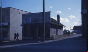
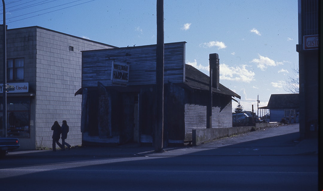
Whitechurch Hardware boarded up
https://search.heritageburnaby.ca/link/museumdescription16893
- Repository
- Burnaby Village Museum
- Date
- Aug. 1974
- Collection/Fonds
- Burnaby Village Museum fonds
- Description Level
- Item
- Physical Description
- 1 photograph : col. slide ; 35 mm
- Scope and Content
- Photograph of the Whitechurch Hardware all boarded up. The building is located at 7685 Sixth Street. A two storey convenience store located at 7695 Sixth Street is visible to the left. The Whitechurch Hardware was moved to Heritage Village (Burnaby Village Museum) in August 1974 by Nickel Brothers…
- Repository
- Burnaby Village Museum
- Collection/Fonds
- Burnaby Village Museum fonds
- Subseries
- Bell's building photographs subseries
- Description Level
- Item
- Physical Description
- 1 photograph : col. slide ; 35 mm
- Scope and Content
- Photograph of the Whitechurch Hardware all boarded up. The building is located at 7685 Sixth Street. A two storey convenience store located at 7695 Sixth Street is visible to the left. The Whitechurch Hardware was moved to Heritage Village (Burnaby Village Museum) in August 1974 by Nickel Brothers house moving company
- Geographic Access
- 6th Street
- Street Address
- 7695 6th Street
- 7685 6th Street
- Accession Code
- BV020.5.1863
- Access Restriction
- No restrictions
- Reproduction Restriction
- No known restrictions
- Date
- Aug. 1974
- Media Type
- Photograph
- Historic Neighbourhood
- East Burnaby (Historic Neighbourhood)
- Planning Study Area
- Second Street Area
- Scan Resolution
- 2400
- Scale
- 100
- Notes
- Title based on contents of photograph
- Note in blue ink on slide frame reads: "Whitechurch on 6th St / boarded up 1974 / (FRONT)"
Images