Narrow Results By
Subject
- Advertising Medium - Signs and Signboards 1
- Aerial Photographs 2
- Animals - Cats 1
- Animals - Dogs 1
- Arts 1
- Arts - Paintings 1
- Buildings - Civic - Libraries 3
- Buildings - Commercial - Banks 1
- Buildings - Commercial - Grocery Stores 3
- Buildings - Commercial - Stores 1
- Buildings - Heritage 3
- Buildings - Industrial 1
![14th Avenue neighbourhood friends, [1925] (date of original), copied 1986 thumbnail](/media/hpo/_Data/_Archives_Images/_Unrestricted/204/204-205.jpg?width=280)
14th Avenue neighbourhood friends
https://search.heritageburnaby.ca/link/archivedescription35348
- Repository
- City of Burnaby Archives
- Date
- [1925] (date of original), copied 1986
- Collection/Fonds
- Burnaby Historical Society fonds
- Description Level
- Item
- Physical Description
- 1 photograph : b&w ; 12.7 x 17.8 cm print
- Scope and Content
- Photograph of the 14th Avenue neighbourhood friends. Back row, left to right: Pearl Scott, Frances Bryson, Alice Salt, and Dorothy Hutchins (holding baby). Middle row, left to right: Hazel Butler, Doris Bamber, Frances Salt, and Jessica Scott. Front row, left to right: Evelyn Salt, Gladys Butler, a…
- Repository
- City of Burnaby Archives
- Date
- [1925] (date of original), copied 1986
- Collection/Fonds
- Burnaby Historical Society fonds
- Subseries
- Pioneer Tales subseries
- Physical Description
- 1 photograph : b&w ; 12.7 x 17.8 cm print
- Description Level
- Item
- Record No.
- 204-205
- Access Restriction
- No restrictions
- Reproduction Restriction
- No known restrictions
- Accession Number
- BHS1988-03
- Scope and Content
- Photograph of the 14th Avenue neighbourhood friends. Back row, left to right: Pearl Scott, Frances Bryson, Alice Salt, and Dorothy Hutchins (holding baby). Middle row, left to right: Hazel Butler, Doris Bamber, Frances Salt, and Jessica Scott. Front row, left to right: Evelyn Salt, Gladys Butler, and Isabel Scott.
- Names
- Bamber, Doris
- Bryson, Frances
- Butler, Gladys
- Hutchins, Dorothy
- Kemp, Hazel Butler
- Salt, Alice
- Salt, Evelyn
- Salt, Frances
- Salt, Isabel
- Scott, Jessica
- Scott, Pearl
- Media Type
- Photograph
- Notes
- Title based on contents of photograph
- Geographic Access
- 14th Avenue
- Historic Neighbourhood
- East Burnaby (Historic Neighbourhood)
Images
![14th Avenue neighbourhood friends, [1925] (date of original), copied 1986 thumbnail](/media/hpo/_Data/_Archives_Images/_Unrestricted/204/204-205.jpg)

100 Years of Gilmore School
https://search.heritageburnaby.ca/link/museumdescription4488
- Repository
- Burnaby Village Museum
- Date
- 2017
- Collection/Fonds
- 100 Years of Gilmore School video collection
- Description Level
- Item
- Physical Description
- 1 video recording (mp4) (34 min., 23 sec.) : digital, 29 fps, col., sd., stereo
- Scope and Content
- "100 Years of Gilmore School". Filmed by Yunuen Perez Vertti and made by the Heights Neighbourhood Association. The film includes interviews with former students and highlights their experiences through the Great Depression, the Second World War and the 1960s.
- Repository
- Burnaby Village Museum
- Collection/Fonds
- 100 Years of Gilmore School video collection
- Description Level
- Item
- Physical Description
- 1 video recording (mp4) (34 min., 23 sec.) : digital, 29 fps, col., sd., stereo
- Scope and Content
- "100 Years of Gilmore School". Filmed by Yunuen Perez Vertti and made by the Heights Neighbourhood Association. The film includes interviews with former students and highlights their experiences through the Great Depression, the Second World War and the 1960s.
- History
- Yunuen Perez Vertti is a filmmaker and digital media artist originally from Mexico City. She has produced films for many public, private and non-profit organizations.
- Creator
- Perez Vertti, Yunuen
- Names
- Gilmore Avenue School
- Responsibility
- Heights Neighbourhood Association
- Geographic Access
- Gilmore Avenue
- Street Address
- 50 Gilmore Avenue
- Accession Code
- BV018.13.1
- Access Restriction
- Restricted access
- Reproduction Restriction
- May be restricted by third party rights
- Date
- 2017
- Media Type
- Moving Images
- Historic Neighbourhood
- Vancouver Heights (Historic Neighbourhood)
- Planning Study Area
- Burnaby Heights Area
- Notes
- Transcribed title
- Reproductions are restricted by copyright holder
Images

Video
100 Years of Gilmore School, 2017
100 Years of Gilmore School, 2017
https://search.heritageburnaby.ca/media/hpo/_Data/_BVM_Moving_Images/2018_0013_0001_001.mp42238 South Gilmore Ave
https://search.heritageburnaby.ca/link/archivedescription94329
- Repository
- City of Burnaby Archives
- Date
- 1995
- Collection/Fonds
- Grover, Elliott & Co. Ltd. fonds
- Description Level
- File
- Physical Description
- 36 photographs : col. negatives ; 35 mm
- Scope and Content
- Photographs of a truck trailor parking lot located at 2238 Gilmore Avenue (an address that no longer exists) and the surrounding industrial area of Gilmore Avenue and Henning Drive. File also includes photographs of the Gilmore Avenue railroad crossing one block north of Still Creek Avenue.
- Repository
- City of Burnaby Archives
- Date
- 1995
- Collection/Fonds
- Grover, Elliott & Co. Ltd. fonds
- Physical Description
- 36 photographs : col. negatives ; 35 mm
- Description Level
- File
- Record No.
- 622-114
- Access Restriction
- No restrictions
- Reproduction Restriction
- No restrictions
- Accession Number
- 2017-39
- Scope and Content
- Photographs of a truck trailor parking lot located at 2238 Gilmore Avenue (an address that no longer exists) and the surrounding industrial area of Gilmore Avenue and Henning Drive. File also includes photographs of the Gilmore Avenue railroad crossing one block north of Still Creek Avenue.
- Media Type
- Photograph
- Notes
- Transcribed title
- Title transcribed from envelope photographs were originally housed in
- File no. 95-027-B
- Geographic Access
- Gilmore Avenue
- Historic Neighbourhood
- Broadview (Historic Neighbourhood)
- Planning Study Area
- West Central Valley Area

Altar at St. Andrew's Anglican Church
https://search.heritageburnaby.ca/link/archivedescription38248
- Repository
- City of Burnaby Archives
- Date
- 1924
- Collection/Fonds
- Burnaby Historical Society fonds
- Description Level
- Item
- Physical Description
- 1 photograph : b&w ; 9 x 12.5 cm
- Scope and Content
- Photograph of the altar at St. Andrew's Anglican Church, prepared for Easter Sunday.
- Repository
- City of Burnaby Archives
- Date
- 1924
- Collection/Fonds
- Burnaby Historical Society fonds
- Subseries
- Margaret McCallum subseries
- Physical Description
- 1 photograph : b&w ; 9 x 12.5 cm
- Description Level
- Item
- Record No.
- 375-009
- Access Restriction
- No restrictions
- Reproduction Restriction
- No known restrictions
- Accession Number
- BHS1986-42
- Scope and Content
- Photograph of the altar at St. Andrew's Anglican Church, prepared for Easter Sunday.
- Media Type
- Photograph
- Notes
- Title based on contents of photograph.
- Geographic Access
- Gilmore Avenue
- Norfolk Street
- Historic Neighbourhood
- Broadview (Historic Neighbourhood)
- Planning Study Area
- Cascade-Schou Area
Images

![Blasting stump, [1921 or 1922] (date of original), digitally copied 2012 thumbnail](/media/hpo/_Data/_Archives_Images/_Unrestricted/540/549-008.jpg?width=280)
Blasting stump
https://search.heritageburnaby.ca/link/archivedescription76891
- Repository
- City of Burnaby Archives
- Date
- [1921 or 1922] (date of original), digitally copied 2012
- Collection/Fonds
- Community Heritage Commission Special Projects fonds
- Description Level
- Item
- Physical Description
- 1 photograph (jpeg) : col. ; 300ppi
- Scope and Content
- Photograph of members of the Brown-John family sitting and standing on the blasting stump. This stump was located near the corner of Gilmore Avenue and Napier Street.
- Repository
- City of Burnaby Archives
- Date
- [1921 or 1922] (date of original), digitally copied 2012
- Collection/Fonds
- Community Heritage Commission Special Projects fonds
- Physical Description
- 1 photograph (jpeg) : col. ; 300ppi
- Description Level
- Item
- Record No.
- 549-008
- Access Restriction
- No restrictions
- Reproduction Restriction
- No known restrictions
- Accession Number
- 2012-30
- Scope and Content
- Photograph of members of the Brown-John family sitting and standing on the blasting stump. This stump was located near the corner of Gilmore Avenue and Napier Street.
- Subjects
- Plants - Trees
- Names
- Brown-John, Victor Joseph Charles
- Brown-John, Archie
- Brown-John, Frank
- Brown-John, Roy
- Ansdell, Elsie Brown-John
- Brown-John, Clive
- Media Type
- Photograph
- Notes
- Title based on contents of photograph
- Geographic Access
- Gilmore Avenue
- Napier Street
- Historic Neighbourhood
- Vancouver Heights (Historic Neighbourhood)
- Planning Study Area
- Willingdon Heights Area
Images
![Blasting stump, [1921 or 1922] (date of original), digitally copied 2012 thumbnail](/media/hpo/_Data/_Archives_Images/_Unrestricted/540/549-008.jpg)
![Blasting stump, [1920] (date of original), digitally copied 2012 thumbnail](/media/hpo/_Data/_Archives_Images/_Unrestricted/540/549-009.jpg?width=280)
Blasting stump
https://search.heritageburnaby.ca/link/archivedescription76892
- Repository
- City of Burnaby Archives
- Date
- [1920] (date of original), digitally copied 2012
- Collection/Fonds
- Community Heritage Commission Special Projects fonds
- Description Level
- Item
- Physical Description
- 1 photograph (jpeg) : col. ; 300ppi
- Scope and Content
- Photograph of the Brown-John children playing on the blasting stump that was located near the corner of Gilmore Avenue and Napier Street.
- Repository
- City of Burnaby Archives
- Date
- [1920] (date of original), digitally copied 2012
- Collection/Fonds
- Community Heritage Commission Special Projects fonds
- Physical Description
- 1 photograph (jpeg) : col. ; 300ppi
- Description Level
- Item
- Record No.
- 549-009
- Access Restriction
- No restrictions
- Reproduction Restriction
- No known restrictions
- Accession Number
- 2012-30
- Scope and Content
- Photograph of the Brown-John children playing on the blasting stump that was located near the corner of Gilmore Avenue and Napier Street.
- Subjects
- Plants - Trees
- Media Type
- Photograph
- Notes
- Title based on contents of photograph
- Geographic Access
- Gilmore Avenue
- Napier Street
- Historic Neighbourhood
- Vancouver Heights (Historic Neighbourhood)
- Planning Study Area
- Willingdon Heights Area
Images
![Blasting stump, [1920] (date of original), digitally copied 2012 thumbnail](/media/hpo/_Data/_Archives_Images/_Unrestricted/540/549-009.jpg)
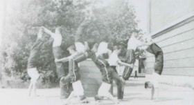
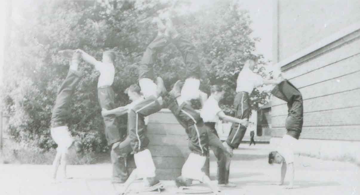
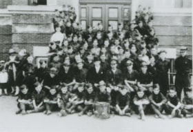
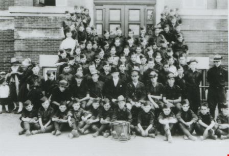
Boys Tumbling Club at Gilmore Avenue Junior High School
https://search.heritageburnaby.ca/link/archivedescription37565
- Repository
- City of Burnaby Archives
- Date
- June 1942 (date of original), copied 1991
- Collection/Fonds
- Burnaby Historical Society fonds
- Description Level
- Item
- Physical Description
- 1 photograph : b&w ; 2.9 x 5.2 cm print on contact sheet 20.2 x 25.3 cm
- Scope and Content
- Photograph of the Boys Tumbling Club at Gilmore Avenue Junior High School. The photograph was taken on school grounds.
- Repository
- City of Burnaby Archives
- Date
- June 1942 (date of original), copied 1991
- Collection/Fonds
- Burnaby Historical Society fonds
- Subseries
- Burnaby Image Bank subseries
- Physical Description
- 1 photograph : b&w ; 2.9 x 5.2 cm print on contact sheet 20.2 x 25.3 cm
- Description Level
- Item
- Record No.
- 370-153
- Access Restriction
- No restrictions
- Reproduction Restriction
- No known restrictions
- Accession Number
- BHS1999-03
- Scope and Content
- Photograph of the Boys Tumbling Club at Gilmore Avenue Junior High School. The photograph was taken on school grounds.
- Names
- Gilmore Avenue School
- Media Type
- Photograph
- Notes
- Title based on contents of photograph
- 1 b&w copy negative accompanying
- Geographic Access
- Gilmore Avenue
- Street Address
- 50 Gilmore Avenue
- Historic Neighbourhood
- Vancouver Heights (Historic Neighbourhood)
- Planning Study Area
- Burnaby Heights Area
Images
![Brantford Coach and Body Ltd., [1959] thumbnail](/media/hpo/_Data/_Archives_Images/_Unrestricted/001/076-001.jpg?width=280)
Brantford Coach and Body Ltd.
https://search.heritageburnaby.ca/link/archivedescription34642
- Repository
- City of Burnaby Archives
- Date
- [1959]
- Collection/Fonds
- Burnaby Historical Society fonds
- Description Level
- Item
- Physical Description
- 1 photograph : b&w ; 20.5 x 25.7 cm
- Scope and Content
- Photograph of the exterior of Brantford Coach and Body Ltd. at 6055 Gilmore Avenue. Signs on the building show the business name and also read, "Sales" and "Service."
- Repository
- City of Burnaby Archives
- Date
- [1959]
- Collection/Fonds
- Burnaby Historical Society fonds
- Subseries
- Photographs subseries
- Physical Description
- 1 photograph : b&w ; 20.5 x 25.7 cm
- Description Level
- Item
- Record No.
- 076-001
- Access Restriction
- No restrictions
- Reproduction Restriction
- Reproduce for fair dealing purposes only
- Accession Number
- BHS2007-04
- Scope and Content
- Photograph of the exterior of Brantford Coach and Body Ltd. at 6055 Gilmore Avenue. Signs on the building show the business name and also read, "Sales" and "Service."
- Subjects
- Buildings - Industrial
- Media Type
- Photograph
- Notes
- Title based on contents of photograph
- Geographic Access
- Gilmore Avenue
- Street Address
- 6055 Gilmore Avenue
Images
![Brantford Coach and Body Ltd., [1959] thumbnail](/media/hpo/_Data/_Archives_Images/_Unrestricted/001/076-001.jpg)

Broadview School
https://search.heritageburnaby.ca/link/archivedescription38237
- Repository
- City of Burnaby Archives
- Date
- 1912
- Collection/Fonds
- Burnaby Historical Society fonds
- Description Level
- Item
- Physical Description
- 1 photograph : sepia ; 16.5 x 21.2 cm on 24.5 x 29.5 cm backing
- Scope and Content
- Photograph of a class of approximately fifty-three children and two teachers outside the newly built Broadview area school. This was the first class photograph at the Broadview School. This shool was later replaced by the Schou Street School and the building was used as a community centre.
- Repository
- City of Burnaby Archives
- Date
- 1912
- Collection/Fonds
- Burnaby Historical Society fonds
- Subseries
- Margaret McCallum subseries
- Physical Description
- 1 photograph : sepia ; 16.5 x 21.2 cm on 24.5 x 29.5 cm backing
- Description Level
- Item
- Record No.
- 375-012
- Access Restriction
- No restrictions
- Reproduction Restriction
- No known restrictions
- Accession Number
- BHS1986-42
- Scope and Content
- Photograph of a class of approximately fifty-three children and two teachers outside the newly built Broadview area school. This was the first class photograph at the Broadview School. This shool was later replaced by the Schou Street School and the building was used as a community centre.
- Names
- Schou Street School
- Media Type
- Photograph
- Notes
- Title based on contents of photograph
- Geographic Access
- Gilmore Avenue
- Grandview Highway
- Canada Way
- Street Address
- 4054 Norfolk Street
- Historic Neighbourhood
- Broadview (Historic Neighbourhood)
- Planning Study Area
- Cascade-Schou Area
Images


Burnaby's Operation Identification
https://search.heritageburnaby.ca/link/archivedescription45330
- Repository
- City of Burnaby Archives
- Date
- 1976, published January 7, 1976
- Collection/Fonds
- Columbian Newspaper collection
- Description Level
- Item
- Physical Description
- 1 photograph : b&w ; 22.5 x 14.5 cm
- Scope and Content
- Photograph of municipal workers Bill Ramsay and Greg Finch putting up a sign in preparation for Burnaby's Operation Identification, which was "the largest single crime prevention policy of its kind in Canada" when "47 uniformed officers of the Burnaby detachment [joined] 47 Rotarians from the Burna…
- Repository
- City of Burnaby Archives
- Date
- 1976, published January 7, 1976
- Collection/Fonds
- Columbian Newspaper collection
- Physical Description
- 1 photograph : b&w ; 22.5 x 14.5 cm
- Description Level
- Item
- Record No.
- 480-225
- Access Restriction
- No restrictions
- Reproduction Restriction
- No restrictions
- Accession Number
- 2003-02
- Scope and Content
- Photograph of municipal workers Bill Ramsay and Greg Finch putting up a sign in preparation for Burnaby's Operation Identification, which was "the largest single crime prevention policy of its kind in Canada" when "47 uniformed officers of the Burnaby detachment [joined] 47 Rotarians from the Burnaby Kingsway Rotary Club and start door-to-door visits in 800 residences in South Burnaby. The teams [carried] electric engraving pens for marking all property susceptible to theft."
- Media Type
- Photograph
- Photographer
- King, Basil
- Notes
- Title based on contents of photograph
- Newspaper clipping attached to verso of photograph reads: "Burnaby detachment of the RCMP has embarked on the largest single crime prevention policy of its kind in Canada. "Operation Identification" officially kicks off tonight when 47 uniformed officers of the Burnaby detachment will join with 47 Rotarians from the Burnaby Kingsway Rotary Club and start door-to-door visits in 800 residences in South Burnaby. The teams will be carrying electric engraving pens for marking all property susceptible to theft. Municipal workers Bill Ramsay and Greg Finch are shown erecting one of the signs on Canada Way at 14th Avenue as "sidewalk superintendents" Sandra Finch and Corinne Williams look on."
- Geographic Access
- Canada Way
- 14th Avenue
- Historic Neighbourhood
- Edmonds (Historic Neighbourhood)
- Planning Study Area
- Edmonds Area
Images

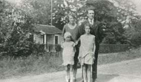
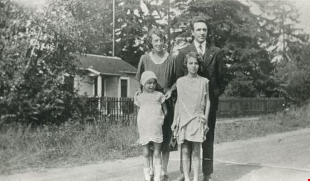
Butler family
https://search.heritageburnaby.ca/link/archivedescription35478
- Repository
- City of Burnaby Archives
- Date
- 1930 (date of original), copied 1986
- Collection/Fonds
- Burnaby Historical Society fonds
- Description Level
- Item
- Physical Description
- 1 photograph : b&w ; 12.7 x 17.8 cm print
- Scope and Content
- Photograph of (back, from left); (parents) Margaret and Edwin Butler; (front, from left) Gladys and Hazel Butler. The Butlers lived at 278 14th Avenue (later renumbered 8062 14th Avenue), East Burnaby.
- Repository
- City of Burnaby Archives
- Date
- 1930 (date of original), copied 1986
- Collection/Fonds
- Burnaby Historical Society fonds
- Subseries
- Pioneer Tales subseries
- Physical Description
- 1 photograph : b&w ; 12.7 x 17.8 cm print
- Description Level
- Item
- Record No.
- 204-336
- Access Restriction
- No restrictions
- Reproduction Restriction
- No known restrictions
- Accession Number
- BHS1988-03
- Scope and Content
- Photograph of (back, from left); (parents) Margaret and Edwin Butler; (front, from left) Gladys and Hazel Butler. The Butlers lived at 278 14th Avenue (later renumbered 8062 14th Avenue), East Burnaby.
- Media Type
- Photograph
- Notes
- Title based on contents of photograph
- Annotation above photograph reads, "The Family - 1930"
- Geographic Access
- 14th Avenue
- Street Address
- 8062 14th Avenue
- Historic Neighbourhood
- East Burnaby (Historic Neighbourhood)
- Planning Study Area
- Second Street Area
Images
Cadet Corp
https://search.heritageburnaby.ca/link/archivedescription37603
- Repository
- City of Burnaby Archives
- Date
- 1926 (date of original), copied 1991
- Collection/Fonds
- Burnaby Historical Society fonds
- Description Level
- Item
- Physical Description
- 1 photograph : b&w ; 3.5 x 5.0 cm print on contact sheet 20.2 x 25.3 cm
- Scope and Content
- Photograph of a Cadet Corps on the steps of Gilmore Avenue School.
- Repository
- City of Burnaby Archives
- Date
- 1926 (date of original), copied 1991
- Collection/Fonds
- Burnaby Historical Society fonds
- Subseries
- Burnaby Image Bank subseries
- Physical Description
- 1 photograph : b&w ; 3.5 x 5.0 cm print on contact sheet 20.2 x 25.3 cm
- Description Level
- Item
- Record No.
- 370-191
- Access Restriction
- No restrictions
- Reproduction Restriction
- No known restrictions
- Accession Number
- BHS1999-03
- Scope and Content
- Photograph of a Cadet Corps on the steps of Gilmore Avenue School.
- Subjects
- Clothing - Uniforms
- Names
- Gilmore Avenue School
- Media Type
- Photograph
- Notes
- Title based on contents of photograph
- 1 b&w copy negative accompanying
- Negative has a pink cast
- Geographic Access
- Gilmore Avenue
- Street Address
- 50 Gilmore Avenue
- Historic Neighbourhood
- Vancouver Heights (Historic Neighbourhood)
- Planning Study Area
- Burnaby Heights Area
Images

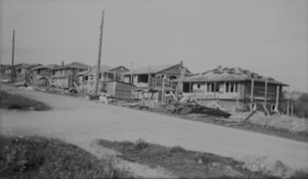
Charles Street and Gilmore Avenue
https://search.heritageburnaby.ca/link/archivedescription34109
- Repository
- City of Burnaby Archives
- Date
- March 22, 1947
- Collection/Fonds
- Burnaby Historical Society fonds
- Description Level
- Item
- Physical Description
- 1 photograph : b&w negative ; 6.8 x 12.0 cm
- Scope and Content
- Photograph of Charles Street and Gilmore Avenue (north) with houses in the distance. This is part of the Willingdon Heights subdivision site.
- Repository
- City of Burnaby Archives
- Date
- March 22, 1947
- Collection/Fonds
- Burnaby Historical Society fonds
- Subseries
- Alfred Bingham subseries
- Physical Description
- 1 photograph : b&w negative ; 6.8 x 12.0 cm
- Description Level
- Item
- Record No.
- 010-025
- Access Restriction
- No restrictions
- Reproduction Restriction
- No known restrictions
- Accession Number
- BHS2007-04
- Scope and Content
- Photograph of Charles Street and Gilmore Avenue (north) with houses in the distance. This is part of the Willingdon Heights subdivision site.
- Subjects
- Geographic Features - Roads
- Media Type
- Photograph
- Photographer
- Bingham, Alfred "Alf"
- Notes
- Title based on contents of photograph
- Geographic Access
- Charles Street
- Gilmore Avenue
Images


Charles Street and Gilmore Avenue
https://search.heritageburnaby.ca/link/archivedescription34114
- Repository
- City of Burnaby Archives
- Date
- March 22, 1947
- Collection/Fonds
- Burnaby Historical Society fonds
- Description Level
- Item
- Physical Description
- 1 photograph : b&w negative ; 6.8 x 10.9 cm
- Scope and Content
- Photograph of Charles Street and Gilmore Avenue with brush along the side. This is part of the Willingdon Heights subdivision site.
- Repository
- City of Burnaby Archives
- Date
- March 22, 1947
- Collection/Fonds
- Burnaby Historical Society fonds
- Subseries
- Alfred Bingham subseries
- Physical Description
- 1 photograph : b&w negative ; 6.8 x 10.9 cm
- Description Level
- Item
- Record No.
- 010-030
- Access Restriction
- No restrictions
- Reproduction Restriction
- No known restrictions
- Accession Number
- BHS2007-04
- Scope and Content
- Photograph of Charles Street and Gilmore Avenue with brush along the side. This is part of the Willingdon Heights subdivision site.
- Subjects
- Geographic Features - Roads
- Media Type
- Photograph
- Photographer
- Bingham, Alfred "Alf"
- Notes
- Title based on contents of photograph
- Geographic Access
- Charles Street
- Gilmore Avenue
Images

Charles Street and Gilmore Avenue
https://search.heritageburnaby.ca/link/archivedescription34132
- Repository
- City of Burnaby Archives
- Date
- April 2, 1947
- Collection/Fonds
- Burnaby Historical Society fonds
- Description Level
- Item
- Physical Description
- 1 photograph : b&w negative ; 6.8 x 11.6 cm
- Scope and Content
- Photograph of house construction at Charles Street and Gilmore Avenue (north). This is part of the Willingdon Heights subdivision site.
- Repository
- City of Burnaby Archives
- Date
- April 2, 1947
- Collection/Fonds
- Burnaby Historical Society fonds
- Subseries
- Alfred Bingham subseries
- Physical Description
- 1 photograph : b&w negative ; 6.8 x 11.6 cm
- Description Level
- Item
- Record No.
- 010-048-2
- Access Restriction
- No restrictions
- Reproduction Restriction
- No known restrictions
- Accession Number
- BHS2007-04
- Scope and Content
- Photograph of house construction at Charles Street and Gilmore Avenue (north). This is part of the Willingdon Heights subdivision site.
- Media Type
- Photograph
- Photographer
- Bingham, Alfred "Alf"
- Notes
- Title based on contents of photograph
- Geographic Access
- Charles Street
- Gilmore Avenue
Images


Charles Street and Gilmore Avenue
https://search.heritageburnaby.ca/link/archivedescription34176
- Repository
- City of Burnaby Archives
- Date
- May 9, 1947
- Collection/Fonds
- Burnaby Historical Society fonds
- Description Level
- Item
- Physical Description
- 1 photograph : b&w negative ; 6.8 x 11.5 cm
- Scope and Content
- Photograph of the Charles Street and Gilmore Avenue intersection with houses under construction on the right side of the street. This is part of the Willingdon Heights subdivision site.
- Repository
- City of Burnaby Archives
- Date
- May 9, 1947
- Collection/Fonds
- Burnaby Historical Society fonds
- Subseries
- Alfred Bingham subseries
- Physical Description
- 1 photograph : b&w negative ; 6.8 x 11.5 cm
- Description Level
- Item
- Record No.
- 010-093
- Access Restriction
- No restrictions
- Reproduction Restriction
- No known restrictions
- Accession Number
- BHS2007-04
- Scope and Content
- Photograph of the Charles Street and Gilmore Avenue intersection with houses under construction on the right side of the street. This is part of the Willingdon Heights subdivision site.
- Media Type
- Photograph
- Photographer
- Bingham, Alfred "Alf"
- Notes
- Title based on contents of photograph
- Geographic Access
- Charles Street
- Gilmore Avenue
Images

![Class at Kitchener Street School, [1936] (date of original), digitally copied 2012 thumbnail](/media/hpo/_Data/_Archives_Images/_Unrestricted/540/549-001.jpg?width=280)
Class at Kitchener Street School
https://search.heritageburnaby.ca/link/archivedescription74809
- Repository
- City of Burnaby Archives
- Date
- [1936] (date of original), digitally copied 2012
- Collection/Fonds
- Community Heritage Commission Special Projects fonds
- Description Level
- Item
- Physical Description
- 1 photograph (jpeg) : col. ; 300ppi
- Scope and Content
- Photograph of Elsie Brown-John's class at Kitchener Street School. Elsie Brown-John (later Ansdell) is sitting at the bottom row, on the far right.
- Repository
- City of Burnaby Archives
- Date
- [1936] (date of original), digitally copied 2012
- Collection/Fonds
- Community Heritage Commission Special Projects fonds
- Physical Description
- 1 photograph (jpeg) : col. ; 300ppi
- Description Level
- Item
- Record No.
- 549-001
- Access Restriction
- No restrictions
- Reproduction Restriction
- No known restrictions
- Accession Number
- 2012-30
- Scope and Content
- Photograph of Elsie Brown-John's class at Kitchener Street School. Elsie Brown-John (later Ansdell) is sitting at the bottom row, on the far right.
- Media Type
- Photograph
- Notes
- Title based on contents of photograph
- Geographic Access
- Gilmore Avenue
- Street Address
- 1351 Gilmore Avenue
- Historic Neighbourhood
- Vancouver Heights (Historic Neighbourhood)
- Planning Study Area
- Willingdon Heights Area
Images
![Class at Kitchener Street School, [1936] (date of original), digitally copied 2012 thumbnail](/media/hpo/_Data/_Archives_Images/_Unrestricted/540/549-001.jpg)
![Class on the front steps of Gilmore Avenue School, [1915] thumbnail](/media/hpo/_Data/_BVM_Images/1985/1985_0100_0001_001.jpg?width=280)
Class on the front steps of Gilmore Avenue School
https://search.heritageburnaby.ca/link/museumdescription2989
- Repository
- Burnaby Village Museum
- Date
- [1915]
- Collection/Fonds
- Burnaby Village Museum Photograph collection
- Description Level
- Item
- Physical Description
- 1 photograph : b&w postcard ; 8.8 x 13.7 cm
- Scope and Content
- Photographic postcard of students from about age eight to ten lined up on the front steps of a school in three rows. The school in the background appears to be the Gilmore Avenue School There are eighteen girls, mostly in knee length dresses or skirts with dark stockings or knee high socks, and se…
- Repository
- Burnaby Village Museum
- Collection/Fonds
- Burnaby Village Museum Photograph collection
- Description Level
- Item
- Physical Description
- 1 photograph : b&w postcard ; 8.8 x 13.7 cm
- Scope and Content
- Photographic postcard of students from about age eight to ten lined up on the front steps of a school in three rows. The school in the background appears to be the Gilmore Avenue School There are eighteen girls, mostly in knee length dresses or skirts with dark stockings or knee high socks, and seventeen boys, in either button up shirts or sailor suits. Annotations on the back of the postcard read: "c. 1915" and "Mr. Smith."
- Subjects
- Documentary Artifacts - Postcards
- Names
- Gilmore Avenue School
- Geographic Access
- Gilmore Avenue
- Street Address
- 50 Gilmore Avenue
- Accession Code
- BV985.100.1
- Access Restriction
- No restrictions
- Reproduction Restriction
- No known restrictions
- Date
- [1915]
- Media Type
- Photograph
- Historic Neighbourhood
- Vancouver Heights (Historic Neighbourhood)
- Planning Study Area
- Burnaby Heights Area
- Scan Resolution
- 600
- Scan Date
- 2024-02-02
- Notes
- Title based on contents of photograph
Images
![Class on the front steps of Gilmore Avenue School, [1915] thumbnail](/media/hpo/_Data/_BVM_Images/1985/1985_0100_0001_001.jpg)

Corner of McGill and Gilmore
https://search.heritageburnaby.ca/link/archivedescription78894
- Repository
- City of Burnaby Archives
- Date
- September 5, 1976
- Collection/Fonds
- Burnaby Public Library Contemporary Visual Archive Project
- Description Level
- Item
- Physical Description
- 1 photograph : b&w ; 11 x 16 cm mounted on cardboard
- Scope and Content
- Photograph shows view of houses and the North Shore from the corner of McGill Street and Gilmore Avenue.
- Repository
- City of Burnaby Archives
- Date
- September 5, 1976
- Collection/Fonds
- Burnaby Public Library Contemporary Visual Archive Project
- Physical Description
- 1 photograph : b&w ; 11 x 16 cm mounted on cardboard
- Description Level
- Item
- Record No.
- 556-019
- Access Restriction
- No restrictions
- Reproduction Restriction
- Reproduce for fair dealing purposes only
- Accession Number
- 2013-13
- Scope and Content
- Photograph shows view of houses and the North Shore from the corner of McGill Street and Gilmore Avenue.
- Subjects
- Aerial Photographs
- Media Type
- Photograph
- Notes
- Scope note taken directly from BPL photograph description.
- 1 b&w copy negative : 10 x 12.5 cm accompanying
- Photographers identified by surnames only: Carr and Vardeman
- Geographic Access
- McGill Street
- Gilmore Avenue
- Historic Neighbourhood
- Vancouver Heights (Historic Neighbourhood)
- Planning Study Area
- Burnaby Heights Area
Images

![Corner view of Love farmhouse, [between 1966 and 1970] thumbnail](/media/hpo/_Data/_BVM_Images/2019/2019_0003_0005_001.jpg?width=280)
Corner view of Love farmhouse
https://search.heritageburnaby.ca/link/museumdescription9919
- Repository
- Burnaby Village Museum
- Date
- [between 1966 and 1970]
- Collection/Fonds
- Love family fonds
- Description Level
- Item
- Physical Description
- 1 photograph : col. ; 10 x 15 cm print
- Scope and Content
- Photograph of the exterior of the Love farmhouse taken at the corner of Fourteenth Avenue and Cumberland Street. The house is hidden behind large trees at it's orignal address of 7651 Cumberland Street (Address pre 1960: 1390 Cumberland Road). This photograph was taken while Elsie Hughes (nee Love)…
- Repository
- Burnaby Village Museum
- Collection/Fonds
- Love family fonds
- Description Level
- Item
- Physical Description
- 1 photograph : col. ; 10 x 15 cm print
- Material Details
- Copy print was made from re-photographing an original colour slide
- Scope and Content
- Photograph of the exterior of the Love farmhouse taken at the corner of Fourteenth Avenue and Cumberland Street. The house is hidden behind large trees at it's orignal address of 7651 Cumberland Street (Address pre 1960: 1390 Cumberland Road). This photograph was taken while Elsie Hughes (nee Love), her husband John Hughes and son Brent Hughes lived in the house. Elsie is the daughter of Sarah (nee Love) and William Parker. Sarah and William purchased the house in 1928, shortly after the death of Sarah's father, Jesse Love. Sarah and William Parker lived in the house with their three children, Albert, Bill and Elsie. William Parker died in 1961 and Sarah continued to live in the house until 1966 before selling it to her daughter Elsie and son in law John Hughes. Elsie and John lived in the house with their son Brent until 1971.
- Subjects
- Buildings - Heritage
- Geographic Access
- 14th Avenue
- Cumberland Street
- Street Address
- 7651 Cumberland Street
- Accession Code
- BV019.3.5
- Access Restriction
- No restrictions
- Reproduction Restriction
- No known restrictions
- Date
- [between 1966 and 1970]
- Media Type
- Photograph
- Historic Neighbourhood
- East Burnaby (Historic Neighbourhood)
- Planning Study Area
- Cariboo-Armstrong Area
- Scan Resolution
- 600
- Scan Date
- 31-Jan-2019
- Scale
- 96
- Photographer
- Parker, Albert "Bert"
- Notes
- Title based on contents of photograph
- See also BV992.15.12
Images
![Corner view of Love farmhouse, [between 1966 and 1970] thumbnail](/media/hpo/_Data/_BVM_Images/2019/2019_0003_0005_001.jpg)