Narrow Results By
Subject
- Advertising Medium - Signs and Signboards 2
- Aerial Photographs 1
- Agriculture - Farms 3
- Agriculture - Fruit and Berries 1
- Agriculture - Orchards 1
- Animals - Cows 2
- Animals - Dogs 1
- Animals - Poultry 2
- Buildings - Civic - Hospitals 11
- Buildings - Commercial - General Stores 1
- Buildings - Commercial - Hotels and Motels 1
- Buildings - Commercial - Service Stations 3
Person / Organization
- Aliceville Hotel 1
- Barnes, Hannah Victoria "Girlie" Love 9
- Barnet Rifle Club 5
- Barnet School 5
- Boy Scouts of Canada 1
- Brandrith, Benjamin Jefferson "Ben" 3
- Brandrith, Martha Dorothy “Dot” Love 14
- British Columbia Electric Railway Company 3
- Brownlee, James Harrison 1
- Burnaby Fish and Game Club 1
- Burnett, Geoffrey K. 2
- Canadian Pacific Railway Company 2

A generation of Love
https://search.heritageburnaby.ca/link/museumdescription18827
- Repository
- Burnaby Village Museum
- Date
- 27 Nov 1971
- Collection/Fonds
- Love family fonds
- Description Level
- Item
- Physical Description
- 1 photograph : b&w ; 15 x 21.5 cm
- Scope and Content
- Photograph of members of the Love family wearing their B.C. Centennial medallions identified from left to right; George R. Love, Martha "Dot" (Love) Brandrith, Esther (Love) Stanley, Phoebe (Love) Feedham, Sarah (Love) Parker and Edith "Minnie" (Love) McKenzie. Photograph appeared in the Province n…
- Repository
- Burnaby Village Museum
- Collection/Fonds
- Love family fonds
- Description Level
- Item
- Physical Description
- 1 photograph : b&w ; 15 x 21.5 cm
- Scope and Content
- Photograph of members of the Love family wearing their B.C. Centennial medallions identified from left to right; George R. Love, Martha "Dot" (Love) Brandrith, Esther (Love) Stanley, Phoebe (Love) Feedham, Sarah (Love) Parker and Edith "Minnie" (Love) McKenzie. Photograph appeared in the Province newspaper on November 27, 1971.
- Names
- Love, George Richard
- Brandrith, Martha Dorothy “Dot” Love
- Stanley, Esther Love
- Feedham, Phoebe Leonard Love
- McKenzie, Edith Minnie Love
- Parker, Sarah Maria Love
- Geographic Access
- Cumberland Street
- Street Address
- 7651 Cumberland Street
- Accession Code
- BV019.8.11
- Access Restriction
- No restrictions
- Reproduction Restriction
- No known restrictions
- Date
- 27 Nov 1971
- Media Type
- Photograph
- Historic Neighbourhood
- East Burnaby (Historic Neighbourhood)
- Planning Study Area
- Cariboo-Armstrong Area
- Scan Resolution
- 600
- Scan Date
- 2022-07-07
- Photographer
- Jones, Charles Spurgeon "Chuck"
- Notes
- Title based on contents of photograph
- Handwritten text on label attached to the back reads: "A. GENERATION OF LOVE / Wearing their B.C. Centennial medallions are six members of / the same family, who have all lived in B.C. prior to 1896. / From left are George R. Love 91 Mrs Martha Brandrith 82 / Mrs F C (Esther) Stanley 75 Mrs Phoebe Feedham 77 / Mrs Sarah Parker 79 Mrs Minnie MacKenzie 86 / Date Picture taken Nov 27. 1971".
- Stamped on the back: "CHUCK JONES / PROVINCE PHOTO".
Images

![Albert Parker with dog, [between 1930 and 1940] (date of original), copied 1998 thumbnail](/media/hpo/_Data/_BVM_Images/2018/2018_0041_0170_001.jpg?width=280)
Albert Parker with dog
https://search.heritageburnaby.ca/link/museumdescription9985
- Repository
- Burnaby Village Museum
- Date
- [between 1930 and 1940] (date of original), copied 1998
- Collection/Fonds
- Burnaby Village Museum fonds
- Description Level
- Item
- Physical Description
- 1 photograph : sepia print ; 13 x 9.5 cm
- Scope and Content
- Photograph of young Albert Parker sitting on the ground with a dog. Behind him is the barn with a model "T" Ford parked inside. Albert is wearing a newsboy cap and is holding a black dog between his knees. In 1928 after Sarah Parker's father, Jesse Love died, William and Sarah (nee Love) Parker pu…
- Repository
- Burnaby Village Museum
- Collection/Fonds
- Burnaby Village Museum fonds
- Series
- Jesse Love farmhouse series
- Subseries
- Love family photographs subseries
- Description Level
- Item
- Physical Description
- 1 photograph : sepia print ; 13 x 9.5 cm
- Scope and Content
- Photograph of young Albert Parker sitting on the ground with a dog. Behind him is the barn with a model "T" Ford parked inside. Albert is wearing a newsboy cap and is holding a black dog between his knees. In 1928 after Sarah Parker's father, Jesse Love died, William and Sarah (nee Love) Parker purchased the Love farmhouse located at 1390 Cumberland Road. They lived there until 1961, with their three children; Albert, Bill and Elsie.
- Subjects
- Buildings - Heritage
- Geographic Access
- Cumberland Street
- Street Address
- 7651 Cumberland Street
- Accession Code
- BV018.41.170
- Access Restriction
- No restrictions
- Reproduction Restriction
- May be restricted by third party rights
- Date
- [between 1930 and 1940] (date of original), copied 1998
- Media Type
- Photograph
- Historic Neighbourhood
- East Burnaby (Historic Neighbourhood)
- Planning Study Area
- Cariboo-Armstrong Area
- Scan Resolution
- 600
- Scan Date
- 25-Feb-2019
- Scale
- 100
- Notes
- Title based on contents of photograph
Images
![Albert Parker with dog, [between 1930 and 1940] (date of original), copied 1998 thumbnail](/media/hpo/_Data/_BVM_Images/2018/2018_0041_0170_001.jpg)
![Aliceville Hotel, [1892] thumbnail](/media/hpo/_Data/_Archives_Images/_Unrestricted/371/421-001.jpg?width=280)
Aliceville Hotel
https://search.heritageburnaby.ca/link/archivedescription38369
- Repository
- City of Burnaby Archives
- Date
- [1892]
- Collection/Fonds
- Burnaby Historical Society fonds
- Description Level
- Item
- Physical Description
- 1 photograph : b&w ; 10 x 12.5 cm
- Scope and Content
- Photograph of the Aliceville Hotel at Burrard Inlet which was built in 1892. On the back of the photograph, a map showing the hotel's location in relation to Hastings Street and North Road has been sketched in pencil.
- Repository
- City of Burnaby Archives
- Date
- [1892]
- Collection/Fonds
- Burnaby Historical Society fonds
- Subseries
- Photographs subseries
- Physical Description
- 1 photograph : b&w ; 10 x 12.5 cm
- Description Level
- Item
- Record No.
- 421-001
- Access Restriction
- No restrictions
- Reproduction Restriction
- No known restrictions
- Accession Number
- BHS2001-10
- Scope and Content
- Photograph of the Aliceville Hotel at Burrard Inlet which was built in 1892. On the back of the photograph, a map showing the hotel's location in relation to Hastings Street and North Road has been sketched in pencil.
- Names
- Aliceville Hotel
- Media Type
- Photograph
- Notes
- Title based on contents of photograph
- Geographic Access
- Hastings Street
- Barnet Road
- Street Address
- 9951 Barnet Road
- Planning Study Area
- Burnaby Mountain Area
Images
![Aliceville Hotel, [1892] thumbnail](/media/hpo/_Data/_Archives_Images/_Unrestricted/371/421-001.jpg)
![A Pretty Dwelling, Barnet B.C., [1907] thumbnail](/media/hpo/_Data/_Archives_Images/_Unrestricted/371/411-008.jpg?width=280)
A Pretty Dwelling, Barnet B.C.
https://search.heritageburnaby.ca/link/archivedescription38349
- Repository
- City of Burnaby Archives
- Date
- [1907]
- Collection/Fonds
- Burnaby Historical Society fonds
- Description Level
- Item
- Physical Description
- 1 photograph : sepia postcard ; 8.5 x 14 cm
- Scope and Content
- Photograph of the front garden and exterior of the North Pacific Lumber Co. (NPLC) Manager's house at Barnet. The caption on the card reads: "A Pretty Dwelling, Barnet B.C."
- Repository
- City of Burnaby Archives
- Date
- [1907]
- Collection/Fonds
- Burnaby Historical Society fonds
- Subseries
- Charles Lee subseries
- Physical Description
- 1 photograph : sepia postcard ; 8.5 x 14 cm
- Description Level
- Item
- Record No.
- 411-008
- Access Restriction
- No restrictions
- Reproduction Restriction
- No known restrictions
- Accession Number
- BHS2000-13
- Scope and Content
- Photograph of the front garden and exterior of the North Pacific Lumber Co. (NPLC) Manager's house at Barnet. The caption on the card reads: "A Pretty Dwelling, Barnet B.C."
- Media Type
- Photograph
- Notes
- Title taken from caption
- Geographic Access
- Barnet Village
- Barnet Road
- Street Address
- 8181 Barnet Road
- Historic Neighbourhood
- Barnet (Historic Neighbourhood)
- Planning Study Area
- Burnaby Mountain Area
Images
![A Pretty Dwelling, Barnet B.C., [1907] thumbnail](/media/hpo/_Data/_Archives_Images/_Unrestricted/371/411-008.jpg)
![Back of the Barnet School, [between 1911 and 1919] thumbnail](/media/hpo/_Data/_Archives_Images/_Unrestricted/316/325-019.jpg?width=280)
Back of the Barnet School
https://search.heritageburnaby.ca/link/archivedescription37147
- Repository
- City of Burnaby Archives
- Date
- [between 1911 and 1919]
- Collection/Fonds
- Burnaby Historical Society fonds
- Description Level
- Item
- Physical Description
- 1 photograph : b&w ; 8.5 x 12.5 cm print
- Scope and Content
- Photograph of the back of the Barnet School and its adjoining teacher's residence.
- Repository
- City of Burnaby Archives
- Date
- [between 1911 and 1919]
- Collection/Fonds
- Burnaby Historical Society fonds
- Subseries
- Disney family subseries
- Physical Description
- 1 photograph : b&w ; 8.5 x 12.5 cm print
- Description Level
- Item
- Record No.
- 325-019
- Access Restriction
- No restrictions
- Reproduction Restriction
- No known restrictions
- Accession Number
- BHS1996-04
- Scope and Content
- Photograph of the back of the Barnet School and its adjoining teacher's residence.
- Subjects
- Buildings - Schools
- Names
- Barnet School
- Media Type
- Photograph
- Photographer
- Disney, John Harold "Jack"
- Notes
- Title based on contents of photograph
- Geographic Access
- Barnet Road
- Street Address
- 7820 Barnet Road
- Historic Neighbourhood
- Barnet (Historic Neighbourhood)
- Planning Study Area
- Burnaby Mountain Area
Images
![Back of the Barnet School, [between 1911 and 1919] thumbnail](/media/hpo/_Data/_Archives_Images/_Unrestricted/316/325-019.jpg)

Barnet Rifle Club
https://search.heritageburnaby.ca/link/archivedescription79712
- Repository
- City of Burnaby Archives
- Date
- September 12, 1976
- Collection/Fonds
- Burnaby Public Library Contemporary Visual Archive Project
- Description Level
- Item
- Physical Description
- 1 photograph : b&w ; 11 x 16 cm mounted on cardboard
- Scope and Content
- Photograph shows the sign at the entrance to the Barnet Rifle Club and the Rifle Range at 8550 Barnet Road.
- Repository
- City of Burnaby Archives
- Date
- September 12, 1976
- Collection/Fonds
- Burnaby Public Library Contemporary Visual Archive Project
- Physical Description
- 1 photograph : b&w ; 11 x 16 cm mounted on cardboard
- Description Level
- Item
- Record No.
- 556-396
- Access Restriction
- No restrictions
- Reproduction Restriction
- Reproduce for fair dealing purposes only
- Accession Number
- 2013-13
- Scope and Content
- Photograph shows the sign at the entrance to the Barnet Rifle Club and the Rifle Range at 8550 Barnet Road.
- Names
- Barnet Rifle Club
- Media Type
- Photograph
- Notes
- Scope note taken directly from BPL photograph description.
- 1 b&w copy negative : 10 x 12.5 cm accompanying
- Photographers identified by surnames only: Carr and Vardeman
- Geographic Access
- Barnet Road
- Street Address
- 8550 Barnet Road
- Historic Neighbourhood
- Barnet (Historic Neighbourhood)
- Planning Study Area
- Burnaby Mountain Area
Images


Barnet Rifle Club
https://search.heritageburnaby.ca/link/archivedescription79713
- Repository
- City of Burnaby Archives
- Date
- September, 1976
- Collection/Fonds
- Burnaby Public Library Contemporary Visual Archive Project
- Description Level
- Item
- Physical Description
- 1 photograph : b&w ; 11 x 16 cm mounted on cardboard
- Scope and Content
- Photograph shows a man ascending the steps of the Barnet Rifle Club Clubhouse.
- Repository
- City of Burnaby Archives
- Date
- September, 1976
- Collection/Fonds
- Burnaby Public Library Contemporary Visual Archive Project
- Physical Description
- 1 photograph : b&w ; 11 x 16 cm mounted on cardboard
- Description Level
- Item
- Record No.
- 556-397
- Access Restriction
- No restrictions
- Reproduction Restriction
- Reproduce for fair dealing purposes only
- Accession Number
- 2013-13
- Scope and Content
- Photograph shows a man ascending the steps of the Barnet Rifle Club Clubhouse.
- Names
- Barnet Rifle Club
- Media Type
- Photograph
- Notes
- Scope note taken directly from BPL photograph description.
- 1 b&w copy negative : 10 x 12.5 cm accompanying
- Photographers identified by surnames only: Carr and Vardeman
- Geographic Access
- Barnet Road
- Street Address
- 8550 Barnet Road
- Historic Neighbourhood
- Barnet (Historic Neighbourhood)
- Planning Study Area
- Burnaby Mountain Area
Images


Barnet Rifle Club
https://search.heritageburnaby.ca/link/archivedescription79714
- Repository
- City of Burnaby Archives
- Date
- September 12, 1976
- Collection/Fonds
- Burnaby Public Library Contemporary Visual Archive Project
- Description Level
- Item
- Physical Description
- 1 photograph : b&w ; 11 x 16 cm mounted on cardboard
- Scope and Content
- Photograph shows the covered firing line at the Barnet Rifle Range.
- Repository
- City of Burnaby Archives
- Date
- September 12, 1976
- Collection/Fonds
- Burnaby Public Library Contemporary Visual Archive Project
- Physical Description
- 1 photograph : b&w ; 11 x 16 cm mounted on cardboard
- Description Level
- Item
- Record No.
- 556-398
- Access Restriction
- No restrictions
- Reproduction Restriction
- Reproduce for fair dealing purposes only
- Accession Number
- 2013-13
- Scope and Content
- Photograph shows the covered firing line at the Barnet Rifle Range.
- Names
- Barnet Rifle Club
- Media Type
- Photograph
- Notes
- Scope note taken directly from BPL photograph description.
- 1 b&w copy negative : 10 x 12.5 cm accompanying
- Photographers identified by surnames only: Carr and Vardeman
- Geographic Access
- Barnet Road
- Street Address
- 8550 Barnet Road
- Historic Neighbourhood
- Barnet (Historic Neighbourhood)
- Planning Study Area
- Burnaby Mountain Area
Images


Barnet Rifle Club
https://search.heritageburnaby.ca/link/archivedescription79716
- Repository
- City of Burnaby Archives
- Date
- September 12, 1976
- Collection/Fonds
- Burnaby Public Library Contemporary Visual Archive Project
- Description Level
- Item
- Physical Description
- 1 photograph : b&w ; 11 x 16 cm mounted on cardboard
- Scope and Content
- Photograph shows two men shooting at targets on the Barnet Rifle Range.
- Repository
- City of Burnaby Archives
- Date
- September 12, 1976
- Collection/Fonds
- Burnaby Public Library Contemporary Visual Archive Project
- Physical Description
- 1 photograph : b&w ; 11 x 16 cm mounted on cardboard
- Description Level
- Item
- Record No.
- 556-399
- Access Restriction
- No restrictions
- Reproduction Restriction
- Reproduce for fair dealing purposes only
- Accession Number
- 2013-13
- Scope and Content
- Photograph shows two men shooting at targets on the Barnet Rifle Range.
- Names
- Barnet Rifle Club
- Media Type
- Photograph
- Notes
- Scope note taken directly from BPL photograph description.
- 1 b&w copy negative : 10 x 12.5 cm accompanying
- Photographers identified by surnames only: Carr and Vardeman
- Geographic Access
- Barnet Road
- Street Address
- 8550 Barnet Road
- Historic Neighbourhood
- Barnet (Historic Neighbourhood)
- Planning Study Area
- Burnaby Mountain Area
Images

![Barnet Road, [1914 or 1915] thumbnail](/media/hpo/_Data/_Archives_Images/_Unrestricted/001/044-001.jpg?width=280)
Barnet Road
https://search.heritageburnaby.ca/link/archivedescription34541
- Repository
- City of Burnaby Archives
- Date
- [1914 or 1915]
- Collection/Fonds
- Burnaby Historical Society fonds
- Description Level
- Item
- Physical Description
- 1 photograph : b&w ; 16.4 x 21.3 cm
- Scope and Content
- Photograph of Barnet Road at North Road. Street signs on the left side of the photograph read, "North Ave" and "Barnet Road." A person on a motorbike or bicycle can be seen on the road in the distance. Utility poles are along the road.
- Repository
- City of Burnaby Archives
- Date
- [1914 or 1915]
- Collection/Fonds
- Burnaby Historical Society fonds
- Subseries
- Photographs subseries
- Physical Description
- 1 photograph : b&w ; 16.4 x 21.3 cm
- Description Level
- Item
- Record No.
- 044-001
- Access Restriction
- No restrictions
- Reproduction Restriction
- No known restrictions
- Accession Number
- BHS2007-04
- Scope and Content
- Photograph of Barnet Road at North Road. Street signs on the left side of the photograph read, "North Ave" and "Barnet Road." A person on a motorbike or bicycle can be seen on the road in the distance. Utility poles are along the road.
- Subjects
- Geographic Features - Roads
- Media Type
- Photograph
- Notes
- Title based on contents of photograph
- Geographic Access
- Barnet Road
- North Road
- Planning Study Area
- Burnaby Mountain Area
Images
![Barnet Road, [1914 or 1915] thumbnail](/media/hpo/_Data/_Archives_Images/_Unrestricted/001/044-001.jpg)

Barnet Road
https://search.heritageburnaby.ca/link/archivedescription35634
- Repository
- City of Burnaby Archives
- Date
- 1922 (date of original), copied 1986
- Collection/Fonds
- Burnaby Historical Society fonds
- Description Level
- Item
- Physical Description
- 1 photograph : b&w ; 12.7 x 17.8 cm print
- Scope and Content
- Photograph of Robert Woolsey carrying his daughter, Margaret, piggy-back along Barnet Road. Note the planked surface. Margaret was two years old at the time. In the upper right corner of the photograph is the Barnet School caretaker's cottage, located beside Barnet School at 7820 Barnet Road.
- Repository
- City of Burnaby Archives
- Date
- 1922 (date of original), copied 1986
- Collection/Fonds
- Burnaby Historical Society fonds
- Subseries
- Pioneer Tales subseries
- Physical Description
- 1 photograph : b&w ; 12.7 x 17.8 cm print
- Description Level
- Item
- Record No.
- 204-492
- Access Restriction
- No restrictions
- Reproduction Restriction
- No known restrictions
- Accession Number
- BHS1988-03
- Scope and Content
- Photograph of Robert Woolsey carrying his daughter, Margaret, piggy-back along Barnet Road. Note the planked surface. Margaret was two years old at the time. In the upper right corner of the photograph is the Barnet School caretaker's cottage, located beside Barnet School at 7820 Barnet Road.
- Subjects
- Geographic Features - Roads
- Media Type
- Photograph
- Notes
- Title based on contents of photograph
- Geographic Access
- Barnet Road
- Street Address
- 7820 Barnet Road
- Historic Neighbourhood
- Barnet (Historic Neighbourhood)
- Planning Study Area
- Burnaby Mountain Area
Images


Barnet Road
https://search.heritageburnaby.ca/link/archivedescription35635
- Repository
- City of Burnaby Archives
- Date
- 1921 (date of original), copied 1986
- Collection/Fonds
- Burnaby Historical Society fonds
- Description Level
- Item
- Physical Description
- 1 photograph : b&w ; 12.7 x 17.8 cm print
- Scope and Content
- Photograph of Barnet Road covered with November snows. The road was always treacherous in winter with snow and rock slides. In the upper right corner of the photograph is Barnet School and caretaker's cottage. Barnet School was located at 7820 Barnet Road.
- Repository
- City of Burnaby Archives
- Date
- 1921 (date of original), copied 1986
- Collection/Fonds
- Burnaby Historical Society fonds
- Subseries
- Pioneer Tales subseries
- Physical Description
- 1 photograph : b&w ; 12.7 x 17.8 cm print
- Description Level
- Item
- Record No.
- 204-493
- Access Restriction
- No restrictions
- Reproduction Restriction
- No known restrictions
- Accession Number
- BHS1988-03
- Scope and Content
- Photograph of Barnet Road covered with November snows. The road was always treacherous in winter with snow and rock slides. In the upper right corner of the photograph is Barnet School and caretaker's cottage. Barnet School was located at 7820 Barnet Road.
- Names
- Barnet School
- Media Type
- Photograph
- Notes
- Title based on contents of photograph
- Geographic Access
- Barnet Road
- Street Address
- 7820 Barnet Road
- Historic Neighbourhood
- Barnet (Historic Neighbourhood)
- Planning Study Area
- Burnaby Mountain Area
Images

![Barnet Road and North Avenue, [1914] thumbnail](/media/hpo/_Data/_BVM_Images/1971/197200110019.jpg?width=280)
Barnet Road and North Avenue
https://search.heritageburnaby.ca/link/museumdescription3105
- Repository
- Burnaby Village Museum
- Date
- [1914]
- Collection/Fonds
- Burnaby Village Museum Photograph collection
- Description Level
- Item
- Physical Description
- 1 photograph : b&w glass negative ; 16.0 x 20.9 cm
- Scope and Content
- Photograph of Barnet Road, a dirt road at the time of the photograph, from North Road. There is a sign post in the foreground to the left that indicates the crossing is "NORTH AVE" and "BARNET RD". On the sign post a provincial notice is tacked on. There are electric posts along one side of Barnet …
- Repository
- Burnaby Village Museum
- Collection/Fonds
- Burnaby Village Museum Photograph collection
- Description Level
- Item
- Physical Description
- 1 photograph : b&w glass negative ; 16.0 x 20.9 cm
- Scope and Content
- Photograph of Barnet Road, a dirt road at the time of the photograph, from North Road. There is a sign post in the foreground to the left that indicates the crossing is "NORTH AVE" and "BARNET RD". On the sign post a provincial notice is tacked on. There are electric posts along one side of Barnet Road, and further down the road is an unidentified man riding a motorcycle or a bicycle. According to an earlier catalogue record from 1988, the view is looking East, and the mountain rising in the background is Burnaby Mountain. The record also dates the negative ca. 1914
- Subjects
- Geographic Features - Roads
- Geographic Access
- Barnet Road
- North Road
- Accession Code
- HV972.11.19
- Access Restriction
- No restrictions
- Reproduction Restriction
- No known restrictions
- Date
- [1914]
- Media Type
- Photograph
- Planning Study Area
- Burnaby Mountain Area
- Scan Resolution
- 300
- Scan Date
- 14/8/2006
- Scale
- 100
- Notes
- Title based on contents of photograph
- 1 b&w contact print accompanying negative
Images
![Barnet Road and North Avenue, [1914] thumbnail](/media/hpo/_Data/_BVM_Images/1971/197200110019.jpg)
![Barnet School, [1913] (date of original), copied 1986 thumbnail](/media/hpo/_Data/_Archives_Images/_Unrestricted/204/204-292.jpg?width=280)
Barnet School
https://search.heritageburnaby.ca/link/archivedescription35434
- Repository
- City of Burnaby Archives
- Date
- [1913] (date of original), copied 1986
- Collection/Fonds
- Burnaby Historical Society fonds
- Description Level
- Item
- Physical Description
- 1 photograph : b&w ; 12.7 x 17.8 cm print
- Scope and Content
- Photograph of 7820 Barnet Road including the Barnet School and adjoining teacher's residence. Dr. Carl Eaton once taught there (this photograph was taken by him). Burnaby Mountain is visible in the background.
- Repository
- City of Burnaby Archives
- Date
- [1913] (date of original), copied 1986
- Collection/Fonds
- Burnaby Historical Society fonds
- Subseries
- Pioneer Tales subseries
- Physical Description
- 1 photograph : b&w ; 12.7 x 17.8 cm print
- Description Level
- Item
- Record No.
- 204-292
- Access Restriction
- No restrictions
- Reproduction Restriction
- No restrictions
- Accession Number
- BHS1988-03
- Scope and Content
- Photograph of 7820 Barnet Road including the Barnet School and adjoining teacher's residence. Dr. Carl Eaton once taught there (this photograph was taken by him). Burnaby Mountain is visible in the background.
- Names
- Barnet School
- Media Type
- Photograph
- Photographer
- Eaton, Dr. Carl
- Notes
- Title based on contents of photograph
- Geographic Access
- Barnet Road
- Street Address
- 7820 Barnet Road
- Historic Neighbourhood
- Barnet (Historic Neighbourhood)
- Planning Study Area
- Burnaby Mountain Area
Images
![Barnet School, [1913] (date of original), copied 1986 thumbnail](/media/hpo/_Data/_Archives_Images/_Unrestricted/204/204-292.jpg)
![Barnet School, [between 1911 and 1919] thumbnail](/media/hpo/_Data/_Archives_Images/_Unrestricted/316/325-018.jpg?width=280)
Barnet School
https://search.heritageburnaby.ca/link/archivedescription37146
- Repository
- City of Burnaby Archives
- Date
- [between 1911 and 1919]
- Collection/Fonds
- Burnaby Historical Society fonds
- Description Level
- Item
- Physical Description
- 1 photograph : b&w ; 8.5 x 12.5 cm print
- Scope and Content
- Photograph of Barnet School and the adjoining teacher's residence.
- Repository
- City of Burnaby Archives
- Date
- [between 1911 and 1919]
- Collection/Fonds
- Burnaby Historical Society fonds
- Subseries
- Disney family subseries
- Physical Description
- 1 photograph : b&w ; 8.5 x 12.5 cm print
- Description Level
- Item
- Record No.
- 325-018
- Access Restriction
- No restrictions
- Reproduction Restriction
- No known restrictions
- Accession Number
- BHS1996-04
- Scope and Content
- Photograph of Barnet School and the adjoining teacher's residence.
- Subjects
- Buildings - Schools
- Names
- Barnet School
- Media Type
- Photograph
- Photographer
- Disney, John Harold "Jack"
- Notes
- Title based on contents of photograph
- Geographic Access
- Barnet Road
- Street Address
- 7820 Barnet Road
- Historic Neighbourhood
- Barnet (Historic Neighbourhood)
- Planning Study Area
- Burnaby Mountain Area
Images
![Barnet School, [between 1911 and 1919] thumbnail](/media/hpo/_Data/_Archives_Images/_Unrestricted/316/325-018.jpg)
![Barnet School Class, [1930 or 1931] thumbnail](/media/hpo/_Data/_Archives_Images/_Unrestricted/001/016-001.jpg?width=280)
Barnet School Class
https://search.heritageburnaby.ca/link/archivedescription34290
- Repository
- City of Burnaby Archives
- Date
- [1930 or 1931]
- Collection/Fonds
- Burnaby Historical Society fonds
- Description Level
- Item
- Physical Description
- 1 photograph : sepia ; 12.5 x 17.6 cm
- Scope and Content
- Photograph of a Barnet School teacher and her class sitting and standing in rows outside the school. Annotation on back of photograph reads, "Barnet School, Barnet BC, 1928", however later information suggests that it is more likely 1930 or 1931.
- Repository
- City of Burnaby Archives
- Date
- [1930 or 1931]
- Collection/Fonds
- Burnaby Historical Society fonds
- Subseries
- Photographs subseries
- Physical Description
- 1 photograph : sepia ; 12.5 x 17.6 cm
- Description Level
- Item
- Record No.
- 016-001
- Access Restriction
- No restrictions
- Reproduction Restriction
- No known restrictions
- Accession Number
- BHS2007-04
- Scope and Content
- Photograph of a Barnet School teacher and her class sitting and standing in rows outside the school. Annotation on back of photograph reads, "Barnet School, Barnet BC, 1928", however later information suggests that it is more likely 1930 or 1931.
- Subjects
- Occupations - Teachers
- Media Type
- Photograph
- Geographic Access
- Barnet Road
- Barnet Village
- Street Address
- 7820 Barnet Road
- Historic Neighbourhood
- Barnet (Historic Neighbourhood)
- Planning Study Area
- Burnaby Mountain Area
Images
![Barnet School Class, [1930 or 1931] thumbnail](/media/hpo/_Data/_Archives_Images/_Unrestricted/001/016-001.jpg)

Barnet School site
https://search.heritageburnaby.ca/link/museumdescription11140
- Repository
- Burnaby Village Museum
- Date
- May 27, 1915
- Collection/Fonds
- Ronald G. Scobbie collection
- Description Level
- Item
- Physical Description
- 1 survey plan : blueprint on paper ; 56 x 54 cm
- Scope and Content
- Survey plan of "Barnet School Site / Burnaby Municipality" "Being a portion of the west half of lot / 214, Group 1 / New Westminster District”.
- Repository
- Burnaby Village Museum
- Collection/Fonds
- Ronald G. Scobbie collection
- Description Level
- Item
- Physical Description
- 1 survey plan : blueprint on paper ; 56 x 54 cm
- Material Details
- Scale 40 feet = 1 inch
- Scope and Content
- Survey plan of "Barnet School Site / Burnaby Municipality" "Being a portion of the west half of lot / 214, Group 1 / New Westminster District”.
- Creator
- McGugan, Donald Johnston
- Subjects
- Buildings - Schools
- Names
- Barnet School
- Responsibility
- Burnett & McGugan, Engineers and Surveyors
- Geographic Access
- Barnet Road
- Street Address
- 7820 Barnet Road
- Accession Code
- BV003.83.19
- Access Restriction
- No restrictions
- Reproduction Restriction
- No known restrictions
- Date
- May 27, 1915
- Media Type
- Cartographic Material
- Historic Neighbourhood
- Barnet (Historic Neighbourhood)
- Planning Study Area
- Burnaby Mountain Area
- Scan Resolution
- 440
- Scan Date
- 22-Dec-2020
- Scale
- 100
- Notes
- Title based on contents of plan
- handwritten on back "Burnaby Schools" "23R" twice, "1783"
- Oath on plan reads: "I, D.J. McGugan...and did personally superintend the survey..." "completed on the 27th day of May 1915"; signed by D.J. McGugan, notarized by "Walter Edmonds" "sworn "...29th day of May 1915" "Burnett and McGugan" "B.C. Land Surveyors Etc. New Westminster, B.C.";
Zoomable Images

![Barnet Village, [1915] (date of original), copied 1986 thumbnail](/media/hpo/_Data/_Archives_Images/_Unrestricted/204/204-295.jpg?width=280)
Barnet Village
https://search.heritageburnaby.ca/link/archivedescription35437
- Repository
- City of Burnaby Archives
- Date
- [1915] (date of original), copied 1986
- Collection/Fonds
- Burnaby Historical Society fonds
- Description Level
- Item
- Physical Description
- 1 photograph : b&w ; 12.7 x 17.8 cm print
- Scope and Content
- Photograph of workers' houses in Barnet Village. Some 700 people were employed by the North Pacific Lumber Co. mill at its peak. The roof of the Canadian Pacific Railway station is visible.
- Repository
- City of Burnaby Archives
- Date
- [1915] (date of original), copied 1986
- Collection/Fonds
- Burnaby Historical Society fonds
- Subseries
- Pioneer Tales subseries
- Physical Description
- 1 photograph : b&w ; 12.7 x 17.8 cm print
- Description Level
- Item
- Record No.
- 204-295
- Access Restriction
- No restrictions
- Reproduction Restriction
- No restrictions
- Accession Number
- BHS1988-03
- Scope and Content
- Photograph of workers' houses in Barnet Village. Some 700 people were employed by the North Pacific Lumber Co. mill at its peak. The roof of the Canadian Pacific Railway station is visible.
- Subjects
- Geographic Features - Neighbourhoods
- Media Type
- Photograph
- Photographer
- Eaton, Dr. Carl
- Notes
- Title based on contents of photograph
- Geographic Access
- Barnet Road
- Street Address
- 8181 Barnet Road
- Historic Neighbourhood
- Barnet (Historic Neighbourhood)
- Planning Study Area
- Burnaby Mountain Area
Images
![Barnet Village, [1915] (date of original), copied 1986 thumbnail](/media/hpo/_Data/_Archives_Images/_Unrestricted/204/204-295.jpg)
![Barnet Village, [1915] (date of original), copied 1986 thumbnail](/media/hpo/_Data/_Archives_Images/_Unrestricted/204/204-296.jpg?width=280)
Barnet Village
https://search.heritageburnaby.ca/link/archivedescription35438
- Repository
- City of Burnaby Archives
- Date
- [1915] (date of original), copied 1986
- Collection/Fonds
- Burnaby Historical Society fonds
- Description Level
- Item
- Physical Description
- 1 photograph : b&w ; 12.7 x 17.8 cm print
- Scope and Content
- Photograph of workers' houses in Barnet Village. Some 700 people were employed by the North Pacific Lumber Co. mill at its peak.
- Repository
- City of Burnaby Archives
- Date
- [1915] (date of original), copied 1986
- Collection/Fonds
- Burnaby Historical Society fonds
- Subseries
- Pioneer Tales subseries
- Physical Description
- 1 photograph : b&w ; 12.7 x 17.8 cm print
- Description Level
- Item
- Record No.
- 204-296
- Access Restriction
- No restrictions
- Reproduction Restriction
- No restrictions
- Accession Number
- BHS1988-03
- Scope and Content
- Photograph of workers' houses in Barnet Village. Some 700 people were employed by the North Pacific Lumber Co. mill at its peak.
- Media Type
- Photograph
- Photographer
- Eaton, Dr. Carl
- Notes
- Title based on contents of photograph
- Geographic Access
- Barnet Road
- Street Address
- 8383 Barnet Road
- Historic Neighbourhood
- Barnet (Historic Neighbourhood)
- Planning Study Area
- Burnaby Mountain Area
Images
![Barnet Village, [1915] (date of original), copied 1986 thumbnail](/media/hpo/_Data/_Archives_Images/_Unrestricted/204/204-296.jpg)

Barnet Wagon Road
https://search.heritageburnaby.ca/link/archivedescription38306
- Repository
- City of Burnaby Archives
- Date
- June 1903 (date of original), copied ca. 1990
- Collection/Fonds
- Burnaby Historical Society fonds
- Description Level
- Item
- Physical Description
- 1 photograph : b&w ; 10 x 15 cm print
- Scope and Content
- Photograph of the Barnet Wagon Road looking west from Sperling Avenue.
- Repository
- City of Burnaby Archives
- Date
- June 1903 (date of original), copied ca. 1990
- Collection/Fonds
- Burnaby Historical Society fonds
- Subseries
- Photographs subseries
- Physical Description
- 1 photograph : b&w ; 10 x 15 cm print
- Description Level
- Item
- Record No.
- 403-001
- Access Restriction
- No restrictions
- Reproduction Restriction
- No known restrictions
- Accession Number
- BHS2007-04
- Scope and Content
- Photograph of the Barnet Wagon Road looking west from Sperling Avenue.
- Subjects
- Land Clearing
- Geographic Features - Roads
- Media Type
- Photograph
- Notes
- Title based on contents of photograph
- Geographic Access
- Barnet Road
- Sperling Avenue
- Historic Neighbourhood
- Lochdale (Historic Neighbourhood)
- Planning Study Area
- Westridge Area
Images


Barnet Wagon Road
https://search.heritageburnaby.ca/link/archivedescription38307
- Repository
- City of Burnaby Archives
- Date
- June 1903 (date of original), copied ca. 1990
- Collection/Fonds
- Burnaby Historical Society fonds
- Description Level
- Item
- Physical Description
- 1 photograph : b&w ; 10 x 15 cm print
- Scope and Content
- Photograph of the Barnet Wagon Road looking east, near Barnet and Hastings.
- Repository
- City of Burnaby Archives
- Date
- June 1903 (date of original), copied ca. 1990
- Collection/Fonds
- Burnaby Historical Society fonds
- Subseries
- Photographs subseries
- Physical Description
- 1 photograph : b&w ; 10 x 15 cm print
- Description Level
- Item
- Record No.
- 403-002
- Access Restriction
- No restrictions
- Reproduction Restriction
- No known restrictions
- Accession Number
- BHS2007-04
- Scope and Content
- Photograph of the Barnet Wagon Road looking east, near Barnet and Hastings.
- Subjects
- Land Clearing
- Geographic Features - Roads
- Media Type
- Photograph
- Notes
- Title based on contents of photograph
- Geographic Access
- Barnet Road
- Hastings Street
- Historic Neighbourhood
- Lochdale (Historic Neighbourhood)
- Planning Study Area
- Westridge Area
Images

![Bea Carpenter, [1951 or 1952] (date of original), copied 1991 thumbnail](/media/hpo/_Data/_Archives_Images/_Unrestricted/370/370-122.jpg?width=280)
Bea Carpenter
https://search.heritageburnaby.ca/link/archivedescription37534
- Repository
- City of Burnaby Archives
- Date
- [1951 or 1952] (date of original), copied 1991
- Collection/Fonds
- Burnaby Historical Society fonds
- Description Level
- Item
- Physical Description
- 1 photograph : b&w ; 2.8 x 3.8 cm print on contact sheet 20.2 x 25.3 cm
- Scope and Content
- Photograph of Bea Carpenter standing beside a car (a 1950 Studebaker) in front of the George Derby Health Centre. She wearing her nurse's uniform.
- Repository
- City of Burnaby Archives
- Date
- [1951 or 1952] (date of original), copied 1991
- Collection/Fonds
- Burnaby Historical Society fonds
- Subseries
- Burnaby Image Bank subseries
- Physical Description
- 1 photograph : b&w ; 2.8 x 3.8 cm print on contact sheet 20.2 x 25.3 cm
- Description Level
- Item
- Record No.
- 370-122
- Access Restriction
- No restrictions
- Reproduction Restriction
- No restrictions
- Accession Number
- BHS1999-03
- Scope and Content
- Photograph of Bea Carpenter standing beside a car (a 1950 Studebaker) in front of the George Derby Health Centre. She wearing her nurse's uniform.
- Media Type
- Photograph
- Notes
- Title based on contents of photograph
- 1 b&w copy negative accompanying
- Geographic Access
- Cumberland Street
- Street Address
- 7550 Cumberland Street
- Historic Neighbourhood
- East Burnaby (Historic Neighbourhood)
- Planning Study Area
- Cariboo-Armstrong Area
Images
![Bea Carpenter, [1951 or 1952] (date of original), copied 1991 thumbnail](/media/hpo/_Data/_Archives_Images/_Unrestricted/370/370-122.jpg)

Bea Carpenter
https://search.heritageburnaby.ca/link/archivedescription37535
- Repository
- City of Burnaby Archives
- Date
- April 10, 1947 (date of original), copied 1991
- Collection/Fonds
- Burnaby Historical Society fonds
- Description Level
- Item
- Physical Description
- 1 photograph : b&w ; 3.7 x 3.1 cm print on contact sheet 20.2 x 25.3 cm
- Scope and Content
- Photograph of Bea Carpenter in the driveway of the George Derby Health Centre on opening day. She is in her nurses uniform and carrying flowers.
- Repository
- City of Burnaby Archives
- Date
- April 10, 1947 (date of original), copied 1991
- Collection/Fonds
- Burnaby Historical Society fonds
- Subseries
- Burnaby Image Bank subseries
- Physical Description
- 1 photograph : b&w ; 3.7 x 3.1 cm print on contact sheet 20.2 x 25.3 cm
- Description Level
- Item
- Record No.
- 370-123
- Access Restriction
- No restrictions
- Reproduction Restriction
- No known restrictions
- Accession Number
- BHS1999-03
- Scope and Content
- Photograph of Bea Carpenter in the driveway of the George Derby Health Centre on opening day. She is in her nurses uniform and carrying flowers.
- Media Type
- Photograph
- Notes
- Title based on contents of photograph
- 1 b&w copy negative accompanying
- Geographic Access
- Cumberland Street
- Street Address
- 7550 Cumberland Street
- Historic Neighbourhood
- East Burnaby (Historic Neighbourhood)
- Planning Study Area
- Cariboo-Armstrong Area
Images


Bea Carpenter
https://search.heritageburnaby.ca/link/archivedescription37536
- Repository
- City of Burnaby Archives
- Date
- 1947 (date of original), copied 1991
- Collection/Fonds
- Burnaby Historical Society fonds
- Description Level
- Item
- Physical Description
- 1 photograph : b&w ; 3.0 x 4.5 cm print on contact sheet 20.2 x 25.3 cm
- Scope and Content
- Photograph of Bea Carpenter in her nurses uniform with the George Derby Health Centre in the background.
- Repository
- City of Burnaby Archives
- Date
- 1947 (date of original), copied 1991
- Collection/Fonds
- Burnaby Historical Society fonds
- Subseries
- Burnaby Image Bank subseries
- Physical Description
- 1 photograph : b&w ; 3.0 x 4.5 cm print on contact sheet 20.2 x 25.3 cm
- Description Level
- Item
- Record No.
- 370-124
- Access Restriction
- No restrictions
- Reproduction Restriction
- No known restrictions
- Accession Number
- BHS1999-03
- Scope and Content
- Photograph of Bea Carpenter in her nurses uniform with the George Derby Health Centre in the background.
- Media Type
- Photograph
- Notes
- Title based on contents of photograph
- 1 b&w copy negative accompanying
- Geographic Access
- Cumberland Street
- Street Address
- 7550 Cumberland Street
- Historic Neighbourhood
- East Burnaby (Historic Neighbourhood)
- Planning Study Area
- Cariboo-Armstrong Area
Images

![Bob Crafter, [193-] (date of original), copied 1991 thumbnail](/media/hpo/_Data/_Archives_Images/_Unrestricted/370/370-007.jpg?width=280)
Bob Crafter
https://search.heritageburnaby.ca/link/archivedescription37419
- Repository
- City of Burnaby Archives
- Date
- [193-] (date of original), copied 1991
- Collection/Fonds
- Burnaby Historical Society fonds
- Description Level
- Item
- Physical Description
- 1 photograph : b&w ; 4.9 x 2.8 cm print on contact sheet 20.2 x 25.4 cm
- Scope and Content
- Photograph of Kask General Store with four people standing in front. Left to right: Australian Bob Crafter and three unidentified young people.
- Repository
- City of Burnaby Archives
- Date
- [193-] (date of original), copied 1991
- Collection/Fonds
- Burnaby Historical Society fonds
- Subseries
- Burnaby Image Bank subseries
- Physical Description
- 1 photograph : b&w ; 4.9 x 2.8 cm print on contact sheet 20.2 x 25.4 cm
- Description Level
- Item
- Record No.
- 370-007
- Access Restriction
- No restrictions
- Reproduction Restriction
- No known restrictions
- Accession Number
- BHS1999-03
- Scope and Content
- Photograph of Kask General Store with four people standing in front. Left to right: Australian Bob Crafter and three unidentified young people.
- Media Type
- Photograph
- Notes
- Title based on contents of photograph
- 1 b&w copy negative accompanying
- Geographic Access
- Barnet Road
- Street Address
- 7501 Barnet Road
- Historic Neighbourhood
- Barnet (Historic Neighbourhood)
- Planning Study Area
- Burnaby Mountain Area
Images
![Bob Crafter, [193-] (date of original), copied 1991 thumbnail](/media/hpo/_Data/_Archives_Images/_Unrestricted/370/370-007.jpg)
![Bob Crafter and Bill Kask, Sr., [193-] (date of original), copied 1991 thumbnail](/media/hpo/_Data/_Archives_Images/_Unrestricted/370/370-008.jpg?width=280)
Bob Crafter and Bill Kask, Sr.
https://search.heritageburnaby.ca/link/archivedescription37420
- Repository
- City of Burnaby Archives
- Date
- [193-] (date of original), copied 1991
- Collection/Fonds
- Burnaby Historical Society fonds
- Description Level
- Item
- Physical Description
- 1 photograph : b&w ; 4.9 x 2.8 cm print on contact sheet 20.2 x 25.4 cm
- Scope and Content
- Photograph of (left to right) Australian Bob Crafter and William "Bill" Kask, Sr., standing in front of Kask General Store.
- Repository
- City of Burnaby Archives
- Date
- [193-] (date of original), copied 1991
- Collection/Fonds
- Burnaby Historical Society fonds
- Subseries
- Burnaby Image Bank subseries
- Physical Description
- 1 photograph : b&w ; 4.9 x 2.8 cm print on contact sheet 20.2 x 25.4 cm
- Description Level
- Item
- Record No.
- 370-008
- Access Restriction
- No restrictions
- Reproduction Restriction
- No known restrictions
- Accession Number
- BHS1999-03
- Scope and Content
- Photograph of (left to right) Australian Bob Crafter and William "Bill" Kask, Sr., standing in front of Kask General Store.
- Subjects
- Occupations - Entrepreneurs
- Media Type
- Photograph
- Notes
- Title based on contents of photograph
- 1 b&w copy negative accompanying
- Geographic Access
- Barnet Road
- Street Address
- 7501 Barnet Road
- Historic Neighbourhood
- Barnet (Historic Neighbourhood)
- Planning Study Area
- Burnaby Mountain Area
Images
![Bob Crafter and Bill Kask, Sr., [193-] (date of original), copied 1991 thumbnail](/media/hpo/_Data/_Archives_Images/_Unrestricted/370/370-008.jpg)
![Bob Love, [191-] thumbnail](/media/hpo/_Data/_BVM_Images/2022/2022_0032_0134_001.jpg?width=280)
Bob Love
https://search.heritageburnaby.ca/link/museumdescription19712
- Repository
- Burnaby Village Museum
- Date
- [191-]
- Collection/Fonds
- Esther Love Stanley fonds
- Description Level
- Item
- Physical Description
- 1 photograph : b&w ; 10.5 x 8 cm
- Scope and Content
- Photograph of Thomas Robert "Bob" Love, standing in an orchard at the Love family home at 1390 Cumberland Road. Bob's right arm is bent with his hand on his waist. He is wearing a white collared shirt with tie, dark pants, belt and suspenders. Orchard trees in full leaf are in background. Bob Love…
- Repository
- Burnaby Village Museum
- Collection/Fonds
- Esther Love Stanley fonds
- Description Level
- Item
- Physical Description
- 1 photograph : b&w ; 10.5 x 8 cm
- Scope and Content
- Photograph of Thomas Robert "Bob" Love, standing in an orchard at the Love family home at 1390 Cumberland Road. Bob's right arm is bent with his hand on his waist. He is wearing a white collared shirt with tie, dark pants, belt and suspenders. Orchard trees in full leaf are in background. Bob Love served in World War 1 and died at the age of 31 years on November 23, 1918.
- Geographic Access
- Cumberland Street
- Street Address
- 7651 Cumberland Street
- Accession Code
- BV022.32.134
- Access Restriction
- No restrictions
- Reproduction Restriction
- No known restrictions
- Date
- [191-]
- Media Type
- Photograph
- Historic Neighbourhood
- East Burnaby (Historic Neighbourhood)
- Planning Study Area
- Cariboo-Armstrong Area
- Related Material
- See also BV022.32.514
- Scan Resolution
- 600
- Scan Date
- 2023-04-04
- Notes
- Title based on contents of photograph
- Photograph is part of Esther Love Stanley photograph album 1 (BV022.32.1)
- Note in white ink on album page reads: "BOB"
Images
![Bob Love, [191-] thumbnail](/media/hpo/_Data/_BVM_Images/2022/2022_0032_0134_001.jpg)
![Bob Love on porch, [191-] thumbnail](/media/hpo/_Data/_BVM_Images/2022/2022_0032_0162_001.jpg?width=280)
Bob Love on porch
https://search.heritageburnaby.ca/link/museumdescription19740
- Repository
- Burnaby Village Museum
- Date
- [191-]
- Collection/Fonds
- Esther Love Stanley fonds
- Description Level
- Item
- Physical Description
- 1 photograph : b&w ; 8 x 10.5 cm
- Scope and Content
- Photograph of Thomas Robert "Bob" Love standing on the front porch of the Love family home on Cumberland Road.
- Repository
- Burnaby Village Museum
- Collection/Fonds
- Esther Love Stanley fonds
- Description Level
- Item
- Physical Description
- 1 photograph : b&w ; 8 x 10.5 cm
- Scope and Content
- Photograph of Thomas Robert "Bob" Love standing on the front porch of the Love family home on Cumberland Road.
- Geographic Access
- Cumberland Street
- Street Address
- 7651 Cumberland Street
- Accession Code
- BV022.32.162
- Access Restriction
- No restrictions
- Reproduction Restriction
- No known restrictions
- Date
- [191-]
- Media Type
- Photograph
- Historic Neighbourhood
- East Burnaby (Historic Neighbourhood)
- Planning Study Area
- Cariboo-Armstrong Area
- Scan Resolution
- 600
- Scan Date
- 2023-04-04
- Notes
- Title based on contents of photograph
- Photograph is part of Esther Love Stanley photograph album 1 (BV022.32.1)
- Annotation in white on album page reads: "Bob"
Images
![Bob Love on porch, [191-] thumbnail](/media/hpo/_Data/_BVM_Images/2022/2022_0032_0162_001.jpg)
![Bob or Henry Love on porch, [191-] thumbnail](/media/hpo/_Data/_BVM_Images/2022/2022_0032_0154_001.jpg?width=280)
Bob or Henry Love on porch
https://search.heritageburnaby.ca/link/museumdescription19732
- Repository
- Burnaby Village Museum
- Date
- [191-]
- Collection/Fonds
- Esther Love Stanley fonds
- Description Level
- Item
- Physical Description
- 1 photograph : b&w ; 10.5 x 8 cm
- Scope and Content
- Photograph of Henry or Bob Love standing on the front porch of the Love family home on Cumberland Road.
- Repository
- Burnaby Village Museum
- Collection/Fonds
- Esther Love Stanley fonds
- Description Level
- Item
- Physical Description
- 1 photograph : b&w ; 10.5 x 8 cm
- Scope and Content
- Photograph of Henry or Bob Love standing on the front porch of the Love family home on Cumberland Road.
- Geographic Access
- Cumberland Street
- Street Address
- 7651 Cumberland Street
- Accession Code
- BV022.32.154
- Access Restriction
- No restrictions
- Reproduction Restriction
- No known restrictions
- Date
- [191-]
- Media Type
- Photograph
- Historic Neighbourhood
- East Burnaby (Historic Neighbourhood)
- Planning Study Area
- Cariboo-Armstrong Area
- Scan Resolution
- 600
- Scan Date
- 2023-04-04
- Notes
- Title based on contents of photograph
- Photograph is part of Esther Love Stanley photograph album 1 (BV022.32.1)
Images
![Bob or Henry Love on porch, [191-] thumbnail](/media/hpo/_Data/_BVM_Images/2022/2022_0032_0154_001.jpg)

B room, northeast view and window
https://search.heritageburnaby.ca/link/museumdescription10769
- Repository
- Burnaby Village Museum
- Date
- May 12, 1988
- Collection/Fonds
- Burnaby Village Museum fonds
- Description Level
- Item
- Physical Description
- 1 photograph : b&w negative ; 35 mm
- Scope and Content
- Photograph of northeast view and window in room "B", upstairs in the Love farmhouse while it was located at 7651 Cumberland Street (the corner of 14th Avenue and Cumberland Street).
- Repository
- Burnaby Village Museum
- Collection/Fonds
- Burnaby Village Museum fonds
- Series
- Jesse Love farmhouse series
- Description Level
- Item
- Physical Description
- 1 photograph : b&w negative ; 35 mm
- Material Details
- Photograph is part of Film roll "D" - 37 b&w photographs that are a part of a collection described as BV018.41.82
- Scope and Content
- Photograph of northeast view and window in room "B", upstairs in the Love farmhouse while it was located at 7651 Cumberland Street (the corner of 14th Avenue and Cumberland Street).
- Subjects
- Buildings - Heritage
- Geographic Access
- Cumberland Street
- Street Address
- 7651 Cumberland Street
- Accession Code
- BV018.41.292
- Access Restriction
- No restrictions
- Reproduction Restriction
- No known restrictions
- Date
- May 12, 1988
- Media Type
- Photograph
- Historic Neighbourhood
- East Burnaby (Historic Neighbourhood)
- Planning Study Area
- Cariboo-Armstrong Area
- Related Material
- See BV018.41.82 for File Level Description
- Scan Resolution
- 2400
- Scan Date
- 13-May-19
- Scale
- 100
- Photographer
- Wolf, Jim
- Notes
- Title based on contents of photograph
- Photograph is a part of file level description "Photographic documentation of changes and move" BV018.41.82
Images


B room, northwest corner and bathtub
https://search.heritageburnaby.ca/link/museumdescription10770
- Repository
- Burnaby Village Museum
- Date
- May 12, 1988
- Collection/Fonds
- Burnaby Village Museum fonds
- Description Level
- Item
- Physical Description
- 1 photograph : b&w negative ; 35 mm
- Scope and Content
- Photograph of the northwest corner and bathtub in room "B", upstairs in the Love farmhouse while it was located at 7651 Cumberland Street (the corner of 14th Avenue and Cumberland Street).
- Repository
- Burnaby Village Museum
- Collection/Fonds
- Burnaby Village Museum fonds
- Series
- Jesse Love farmhouse series
- Description Level
- Item
- Physical Description
- 1 photograph : b&w negative ; 35 mm
- Material Details
- Photograph is part of Film roll "D" - 37 b&w photographs that are a part of a collection described as BV018.41.82
- Scope and Content
- Photograph of the northwest corner and bathtub in room "B", upstairs in the Love farmhouse while it was located at 7651 Cumberland Street (the corner of 14th Avenue and Cumberland Street).
- Subjects
- Buildings - Heritage
- Geographic Access
- Cumberland Street
- Street Address
- 7651 Cumberland Street
- Accession Code
- BV018.41.293
- Access Restriction
- No restrictions
- Reproduction Restriction
- No known restrictions
- Date
- May 12, 1988
- Media Type
- Photograph
- Historic Neighbourhood
- East Burnaby (Historic Neighbourhood)
- Planning Study Area
- Cariboo-Armstrong Area
- Related Material
- See BV018.41.82 for File Level Description
- Scan Resolution
- 2400
- Scan Date
- 13-May-19
- Scale
- 100
- Photographer
- Wolf, Jim
- Notes
- Title based on contents of photograph
- Photograph is a part of file level description "Photographic documentation of changes and move" BV018.41.82
Images

![Buildings at the submarine works yard, [1917] (date of original), copied 2004 thumbnail](/media/hpo/_Data/_Archives_Images/_Unrestricted/371/466-004.jpg?width=280)
Buildings at the submarine works yard
https://search.heritageburnaby.ca/link/archivedescription38605
- Repository
- City of Burnaby Archives
- Date
- [1917] (date of original), copied 2004
- Collection/Fonds
- Burnaby Historical Society fonds
- Description Level
- Item
- Physical Description
- 1 photograph : b&w ; 20 x 28 cm print
- Scope and Content
- Photograph of a large building at the site of the submarine works yard in Barnet. During World War One, the Royal Russian Navy contracted with a Seattle-based company to build submarines for Russia, but American neutrality in the war prevented the subs from being built in the United States. Instea…
- Repository
- City of Burnaby Archives
- Date
- [1917] (date of original), copied 2004
- Collection/Fonds
- Burnaby Historical Society fonds
- Subseries
- Jim Wolf subseries
- Physical Description
- 1 photograph : b&w ; 20 x 28 cm print
- Description Level
- Item
- Record No.
- 466-004
- Access Restriction
- No restrictions
- Reproduction Restriction
- No known restrictions
- Accession Number
- BHS2004-9
- Scope and Content
- Photograph of a large building at the site of the submarine works yard in Barnet. During World War One, the Royal Russian Navy contracted with a Seattle-based company to build submarines for Russia, but American neutrality in the war prevented the subs from being built in the United States. Instead, the company operated a facility at Barnet to complete the contract.
- Subjects
- Buildings - Industrial
- Transportation - Submarines
- Wars - World War, 1914-1918
- Occupations - Labourers
- Names
- Royal Russian Navy
- Media Type
- Photograph
- Notes
- Title based on contents of photograph.
- Geographic Access
- Barnet Village
- Barnet Road
- Street Address
- 8774 Barnet Road
- Historic Neighbourhood
- Barnet (Historic Neighbourhood)
- Planning Study Area
- Burnaby Mountain Area
Images
![Buildings at the submarine works yard, [1917] (date of original), copied 2004 thumbnail](/media/hpo/_Data/_Archives_Images/_Unrestricted/371/466-004.jpg)

Burnaby Fish and Game Club Range
https://search.heritageburnaby.ca/link/archivedescription79719
- Repository
- City of Burnaby Archives
- Date
- September 12, 1976
- Collection/Fonds
- Burnaby Public Library Contemporary Visual Archive Project
- Description Level
- Item
- Physical Description
- 1 photograph : b&w ; 11 x 16 cm mounted on cardboard
- Scope and Content
- Photograph shows cars parked outside the Burnaby Fish and Game Club Rifle Range at 8242 Barnet Road.
- Repository
- City of Burnaby Archives
- Date
- September 12, 1976
- Collection/Fonds
- Burnaby Public Library Contemporary Visual Archive Project
- Physical Description
- 1 photograph : b&w ; 11 x 16 cm mounted on cardboard
- Description Level
- Item
- Record No.
- 556-400
- Access Restriction
- No restrictions
- Reproduction Restriction
- Reproduce for fair dealing purposes only
- Accession Number
- 2013-13
- Scope and Content
- Photograph shows cars parked outside the Burnaby Fish and Game Club Rifle Range at 8242 Barnet Road.
- Media Type
- Photograph
- Notes
- Scope note taken directly from BPL photograph description.
- 1 b&w copy negative : 10 x 12.5 cm accompanying
- Photographers identified by surnames only: Carr and Vardeman
- Geographic Access
- Barnet Road
- Street Address
- 8242 Barnet Road
- Historic Neighbourhood
- Barnet (Historic Neighbourhood)
- Planning Study Area
- Burnaby Mountain Area
Images


Burnaby Lake Interurban line
https://search.heritageburnaby.ca/link/archivedescription36810
- Repository
- City of Burnaby Archives
- Date
- 1926 (date of original), copied 1992
- Collection/Fonds
- Burnaby Historical Society fonds
- Description Level
- Item
- Physical Description
- 1 photograph : b&w ; 7.0 x 12.7 cm print
- Scope and Content
- Photograph of a tram on the Burnaby Lake Interurban line at the Cumberland Road station.
- Repository
- City of Burnaby Archives
- Date
- 1926 (date of original), copied 1992
- Collection/Fonds
- Burnaby Historical Society fonds
- Subseries
- Burnaby Centennial Anthology subseries
- Physical Description
- 1 photograph : b&w ; 7.0 x 12.7 cm print
- Description Level
- Item
- Record No.
- 315-268
- Access Restriction
- No restrictions
- Reproduction Restriction
- No known restrictions
- Accession Number
- BHS1994-04
- Scope and Content
- Photograph of a tram on the Burnaby Lake Interurban line at the Cumberland Road station.
- Media Type
- Photograph
- Notes
- Title based on contents of photograph
- Geographic Access
- Cumberland Street
- Burnaby Lake Interurban line
- Historic Neighbourhood
- East Burnaby (Historic Neighbourhood)
- Planning Study Area
- Cariboo-Armstrong Area
Images

![Burnaby Velodrome Club indoor bike track, [2004] thumbnail](/media/hpo/_Data/_Archives_Images/_Unrestricted/535/535-2068-2.jpg?width=280)
Burnaby Velodrome Club indoor bike track
https://search.heritageburnaby.ca/link/archivedescription96398
- Repository
- City of Burnaby Archives
- Date
- [2004]
- Collection/Fonds
- Burnaby NewsLeader photograph collection
- Description Level
- File
- Physical Description
- 2 photographs (tiff) : col.
- Scope and Content
- File contains photographs of Quentin Adrian of the Burnaby Velodrome Club posing on the wooden indoor bike track at the Harry Jerome Sports Centre. The track, inflatable roof, and other sports settings are visible behind Adrian.
- Repository
- City of Burnaby Archives
- Date
- [2004]
- Collection/Fonds
- Burnaby NewsLeader photograph collection
- Physical Description
- 2 photographs (tiff) : col.
- Description Level
- File
- Record No.
- 535-2068
- Access Restriction
- No restrictions
- Reproduction Restriction
- No restrictions
- Accession Number
- 2018-12
- Scope and Content
- File contains photographs of Quentin Adrian of the Burnaby Velodrome Club posing on the wooden indoor bike track at the Harry Jerome Sports Centre. The track, inflatable roof, and other sports settings are visible behind Adrian.
- Media Type
- Photograph
- Photographer
- Bartel, Mario
- Notes
- Title based on caption
- Collected by editorial for use in a March 2004 issue of the Burnaby NewsLeader
- Caption from metadata: "Quentin Adrian, of the Burnaby Velodrome Club, says the future is looking bright for North America's only indoor bike track after the Club received an infrastructure grant."
- Geographic Access
- Barnet Road
- Street Address
- 7564 Barnet Road
- Historic Neighbourhood
- Barnet (Historic Neighbourhood)
- Planning Study Area
- Burnaby Mountain Area
Images
![Burnaby Velodrome Club indoor bike track, [2004] thumbnail](/media/hpo/_Data/_Archives_Images/_Unrestricted/535/535-2068-2.jpg)
![Burnaby Velodrome Club's Race Series, [2003] thumbnail](/media/hpo/_Data/_Archives_Images/_Unrestricted/535/535-2024-1.jpg?width=280)
Burnaby Velodrome Club's Race Series
https://search.heritageburnaby.ca/link/archivedescription96343
- Repository
- City of Burnaby Archives
- Date
- [2003]
- Collection/Fonds
- Burnaby NewsLeader photograph collection
- Description Level
- File
- Physical Description
- 2 photographs (tiff) : col.
- Scope and Content
- File contains photographs of cycling races in the Burnaby Velodrome Club's Race Series at the Harry Jerome Sports Centre. Photographs depict Enrico Traini in the Flying 200 Sprint and Breanna Loster in the Flying 200-Category B sprint.
- Repository
- City of Burnaby Archives
- Date
- [2003]
- Collection/Fonds
- Burnaby NewsLeader photograph collection
- Physical Description
- 2 photographs (tiff) : col.
- Description Level
- File
- Record No.
- 535-2024
- Access Restriction
- No restrictions
- Reproduction Restriction
- No restrictions
- Accession Number
- 2018-12
- Scope and Content
- File contains photographs of cycling races in the Burnaby Velodrome Club's Race Series at the Harry Jerome Sports Centre. Photographs depict Enrico Traini in the Flying 200 Sprint and Breanna Loster in the Flying 200-Category B sprint.
- Subjects
- Sports - Cycling
- Media Type
- Photograph
- Photographer
- Bartel, Mario
- Notes
- Title based on caption
- Collected by editorial for use in a February 2003 issue of the Burnaby NewsLeader
- Caption from metadata for 535-2024-1: "Enrico Traini begins his sprint to the finish in the Flying 200 Sprint competition at the Burnaby Velodrome Club's Race Series, Saturday at the Harry Jerome Sports Centre. More than 60 riders, from as far away as Portland, Calgary and Quebec competed in the Club's first event since the installation of a new roof last month."
- Caption from metadata for 535-2024-2: "Breanna Loster concentrates as she sprints for the finish in the Flying 200-Category B Sprint competition at the Burnaby Velodrome Club's Racing Series, Saturday at the Harry Jerome Sports Centre."
- Geographic Access
- Barnet Road
- Street Address
- 7564 Barnet Road
- Historic Neighbourhood
- Barnet (Historic Neighbourhood)
- Planning Study Area
- Burnaby Mountain Area
Images
![Burnaby Velodrome Club's Race Series, [2003] thumbnail](/media/hpo/_Data/_Archives_Images/_Unrestricted/535/535-2024-1.jpg)

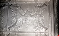
Ceiling in parlour
https://search.heritageburnaby.ca/link/museumdescription10812
- Repository
- Burnaby Village Museum
- Date
- April 8, 1988
- Collection/Fonds
- Burnaby Village Museum fonds
- Description Level
- Item
- Physical Description
- 1 photograph : col. negative ; 35 mm
- Scope and Content
- Photograph of the tin ceiling in the parlour inside of the Love farmhouse while it was located at 7651 Cumberland Street (the corner of 14th Avenue and Cumberland Street). The photograph was taken of the house once it was saved and acquired by the Burnaby Village Museum.
- Repository
- Burnaby Village Museum
- Collection/Fonds
- Burnaby Village Museum fonds
- Series
- Jesse Love farmhouse series
- Description Level
- Item
- Physical Description
- 1 photograph : col. negative ; 35 mm
- Material Details
- Photograph is part of Film roll "F" - 23 colour photographs that are a part of a collection described as BV018.41.82
- Scope and Content
- Photograph of the tin ceiling in the parlour inside of the Love farmhouse while it was located at 7651 Cumberland Street (the corner of 14th Avenue and Cumberland Street). The photograph was taken of the house once it was saved and acquired by the Burnaby Village Museum.
- Subjects
- Buildings - Heritage
- Geographic Access
- Cumberland Street
- Street Address
- 7651 Cumberland Street
- Accession Code
- BV018.41.334
- Access Restriction
- No restrictions
- Reproduction Restriction
- No known restrictions
- Date
- April 8, 1988
- Media Type
- Photograph
- Historic Neighbourhood
- East Burnaby (Historic Neighbourhood)
- Planning Study Area
- Cariboo-Armstrong Area
- Related Material
- See BV018.41.82 for File Level Description
- Scan Resolution
- 2400
- Scan Date
- 13-May-19
- Scale
- 100
- Photographer
- Wolf, Jim
- Notes
- Title based on contents of photograph
- Photograph is a part of file level description "Photographic documentation of changes and move" BV018.41.82
Images


Cement Truck from Kask Bros.
https://search.heritageburnaby.ca/link/archivedescription78986
- Repository
- City of Burnaby Archives
- Date
- October 1, 1976
- Collection/Fonds
- Burnaby Public Library Contemporary Visual Archive Project
- Description Level
- Item
- Physical Description
- 1 photograph : b&w ; 11 x 16 cm mounted on cardboard
- Scope and Content
- Photograph shows a cement truck from Kask Bros. Rady Mix Ltd. along the drive through Kask Kamp.
- Repository
- City of Burnaby Archives
- Date
- October 1, 1976
- Collection/Fonds
- Burnaby Public Library Contemporary Visual Archive Project
- Physical Description
- 1 photograph : b&w ; 11 x 16 cm mounted on cardboard
- Description Level
- Item
- Record No.
- 556-071
- Access Restriction
- No restrictions
- Reproduction Restriction
- Reproduce for fair dealing purposes only
- Accession Number
- 2013-13
- Scope and Content
- Photograph shows a cement truck from Kask Bros. Rady Mix Ltd. along the drive through Kask Kamp.
- Subjects
- Transportation - Trucks
- Names
- Kask Brothers
- Kask Camp
- Media Type
- Photograph
- Photographer
- Born, A. J.
- Notes
- Scope note taken directly from BPL photograph description.
- 1 b&w copy negative : 10 x 12.5 cm accompanying
- Geographic Access
- Barnet Road
- Historic Neighbourhood
- Barnet (Historic Neighbourhood)
- Planning Study Area
- Burnaby Mountain Area
Images

Christianity -- what is it? : five lectures on Dr. Harnack's "wesen des christentums"
https://search.heritageburnaby.ca/link/museumlibrary3509
- Repository
- Burnaby Village Museum
- Collection
- Special Collection
- Material Type
- Book
- Accession Code
- BV988.33.60
- Call Number
- 270 MAS
- Place of Publication
- London
- Publisher
- Society for Promoting Christian Knowledge
- Publication Date
- 1902
- Inscription
- "Presented by the Society for Promoting Christian Knowledge. Not to be Given Away" [stamp in purple on title page] "Bought at secondhand store for 50 cents" [handwritten in pencil on title page] "Please return to Albert Henkea Rm. 11 Hut 29 Acadia Camp, UBC" [handwritten in pencil and blue ink on prefatory note page]
- Library Subject (LOC)
- Christianity
- Historic Neighbourhood
- East Burnaby (Historic Neighbourhood)
- Geographic Access
- Cumberland Street
- Object History
- object was found in the Jesse Love farmhouse when moved to the Museum.
- Notes
- Author's full name and dates: Mason, Arthur James, 1851-1928
Christmas with Grandma Elsie
https://search.heritageburnaby.ca/link/museumlibrary3579
- Repository
- Burnaby Village Museum
- Author
- Finley, Martha, 1828-1909
- Publication Date
- 1889
- Call Number
- 813.4 FIN
- Repository
- Burnaby Village Museum
- Collection
- Special Collection
- Material Type
- Book
- Accession Code
- BV997.45.23
- Call Number
- 813.4 FIN
- Author
- Finley, Martha, 1828-1909
- Place of Publication
- London
- Publisher
- George Routledge and Sons
- Publication Date
- 1889
- Series
- Elsie Books
- Printer
- L. Upcott Gill
- Physical Description
- 317 p. : 19 cm.
- Library Subject (LOC)
- Children--Conduct of life
- Conduct of life
- Grandmothers
- Intergenerational relations
- Christmas
- Families
- Christian life
- United States--History--Civil War, 1861-1865
- United States
- Juvenile fiction
- Historic Neighbourhood
- East Burnaby (Historic Neighbourhood)
- Geographic Access
- Cumberland Street
- Object History
- This artifact has been passed down to all the girls in subsequent generations of the family, eventually to the donor, Mrs. Whiting. This series of 26 "Elsie" girls books are said, by the donor, to have been purchased by Jesse Love and his son in law Wallace (Flash) Whiting for the youngest of Jesse and Martha Love's children Hannah Victoria (Girlie) Love, age 10 at the time, and Annie (Love) Whiting's daughter Edith, age 8 at the time. The book series seems to have made their way through some of Jesse Love's daughter's children. Mrs. Whiting. Sarah (Love) Parker, daughter of Jesse Love, even named her daughter Elsie (Parker) Hughes after the main character of the series. The books seem to have made their way through the children and grand children of Annie (Love) and Wallace Whiting. The were donated by Edna Whiting, the daughter in law of Alfred Whiting, one of Annie's sons.

Cooling cupboard in basement
https://search.heritageburnaby.ca/link/museumdescription10867
- Repository
- Burnaby Village Museum
- Date
- April 11, 1988
- Collection/Fonds
- Burnaby Village Museum fonds
- Description Level
- Item
- Physical Description
- 1 photograph : b&w negative ; 35 mm
- Scope and Content
- Photograph of cooling cupboard in along the wast wall in the basement of the Love farmhouse located at 7651 Cumberland Street (the corner of 14th Avenue and Cumberland Street). The photograph was taken of the house once it was saved and acquired by the Burnaby Village Museum.
- Repository
- Burnaby Village Museum
- Collection/Fonds
- Burnaby Village Museum fonds
- Series
- Jesse Love farmhouse series
- Description Level
- Item
- Physical Description
- 1 photograph : b&w negative ; 35 mm
- Material Details
- Photograph is part of Film roll "H" - 36 b&w photographs that are a part of a collection described as BV018.41.82
- Scope and Content
- Photograph of cooling cupboard in along the wast wall in the basement of the Love farmhouse located at 7651 Cumberland Street (the corner of 14th Avenue and Cumberland Street). The photograph was taken of the house once it was saved and acquired by the Burnaby Village Museum.
- Subjects
- Buildings - Heritage
- Geographic Access
- Cumberland Street
- Street Address
- 7651 Cumberland Street
- Accession Code
- BV018.41.389
- Access Restriction
- No restrictions
- Reproduction Restriction
- No known restrictions
- Date
- April 11, 1988
- Media Type
- Photograph
- Historic Neighbourhood
- East Burnaby (Historic Neighbourhood)
- Planning Study Area
- Cariboo-Armstrong Area
- Related Material
- See BV018.41.82 for File Level Description
- Scan Resolution
- 2400
- Scan Date
- 6/3/2019
- Scale
- 100
- Photographer
- Wolf, Jim
- Notes
- Title based on contents of photograph
- Photograph is a part of file level description "Photographic documentation of changes and move" BV018.41.82
Images

![Corner view of Love farmhouse, [between 1966 and 1970] thumbnail](/media/hpo/_Data/_BVM_Images/2019/2019_0003_0005_001.jpg?width=280)
Corner view of Love farmhouse
https://search.heritageburnaby.ca/link/museumdescription9919
- Repository
- Burnaby Village Museum
- Date
- [between 1966 and 1970]
- Collection/Fonds
- Love family fonds
- Description Level
- Item
- Physical Description
- 1 photograph : col. ; 10 x 15 cm print
- Scope and Content
- Photograph of the exterior of the Love farmhouse taken at the corner of Fourteenth Avenue and Cumberland Street. The house is hidden behind large trees at it's orignal address of 7651 Cumberland Street (Address pre 1960: 1390 Cumberland Road). This photograph was taken while Elsie Hughes (nee Love)…
- Repository
- Burnaby Village Museum
- Collection/Fonds
- Love family fonds
- Description Level
- Item
- Physical Description
- 1 photograph : col. ; 10 x 15 cm print
- Material Details
- Copy print was made from re-photographing an original colour slide
- Scope and Content
- Photograph of the exterior of the Love farmhouse taken at the corner of Fourteenth Avenue and Cumberland Street. The house is hidden behind large trees at it's orignal address of 7651 Cumberland Street (Address pre 1960: 1390 Cumberland Road). This photograph was taken while Elsie Hughes (nee Love), her husband John Hughes and son Brent Hughes lived in the house. Elsie is the daughter of Sarah (nee Love) and William Parker. Sarah and William purchased the house in 1928, shortly after the death of Sarah's father, Jesse Love. Sarah and William Parker lived in the house with their three children, Albert, Bill and Elsie. William Parker died in 1961 and Sarah continued to live in the house until 1966 before selling it to her daughter Elsie and son in law John Hughes. Elsie and John lived in the house with their son Brent until 1971.
- Subjects
- Buildings - Heritage
- Geographic Access
- 14th Avenue
- Cumberland Street
- Street Address
- 7651 Cumberland Street
- Accession Code
- BV019.3.5
- Access Restriction
- No restrictions
- Reproduction Restriction
- No known restrictions
- Date
- [between 1966 and 1970]
- Media Type
- Photograph
- Historic Neighbourhood
- East Burnaby (Historic Neighbourhood)
- Planning Study Area
- Cariboo-Armstrong Area
- Scan Resolution
- 600
- Scan Date
- 31-Jan-2019
- Scale
- 96
- Photographer
- Parker, Albert "Bert"
- Notes
- Title based on contents of photograph
- See also BV992.15.12
Images
![Corner view of Love farmhouse, [between 1966 and 1970] thumbnail](/media/hpo/_Data/_BVM_Images/2019/2019_0003_0005_001.jpg)
![Corner view of Love farmhouse, [between 1966 and 1970] thumbnail](/media/hpo/_Data/_BVM_Images/2019/2019_0003_0006_001.jpg?width=280)
Corner view of Love farmhouse
https://search.heritageburnaby.ca/link/museumdescription9920
- Repository
- Burnaby Village Museum
- Date
- [between 1966 and 1970]
- Collection/Fonds
- Love family fonds
- Description Level
- Item
- Physical Description
- 1 photograph : col. ; 10 x 15 cm print
- Scope and Content
- Photograph of the exterior of the Love farmhouse taken at the corner of Fourteenth Avenue and Cumberland Street. The north side of the house and kitchen are in view with large trees covering the front of the house at it's orignal address of 7651 Cumberland Street (Address pre 1960: 1390 Cumberland …
- Repository
- Burnaby Village Museum
- Collection/Fonds
- Love family fonds
- Description Level
- Item
- Physical Description
- 1 photograph : col. ; 10 x 15 cm print
- Material Details
- Copy print was made from re-photographing an original colour slide
- Scope and Content
- Photograph of the exterior of the Love farmhouse taken at the corner of Fourteenth Avenue and Cumberland Street. The north side of the house and kitchen are in view with large trees covering the front of the house at it's orignal address of 7651 Cumberland Street (Address pre 1960: 1390 Cumberland Road). This photograph was taken while Elsie Hughes (nee Love), her husband John Hughes and son Brent Hughes lived in the house. Elsie is the daughter of Sarah (nee Love) and William Parker. Sarah and William purchased the house in 1928, shortly after the death of Sarah's father, Jesse Love. Sarah and William Parker lived in the house with their three children, Albert, Bill and Elsie. William Parker died in 1961 and Sarah continued to live in the house until 1966 before selling it to her daughter Elsie and son in law John Hughes. Elsie and John lived in the house with their son Brent until 1971.
- Subjects
- Buildings - Heritage
- Geographic Access
- 14th Avenue
- Cumberland Street
- Street Address
- 7651 Cumberland Street
- Accession Code
- BV019.3.6
- Access Restriction
- No restrictions
- Reproduction Restriction
- No known restrictions
- Date
- [between 1966 and 1970]
- Media Type
- Photograph
- Historic Neighbourhood
- East Burnaby (Historic Neighbourhood)
- Planning Study Area
- Cariboo-Armstrong Area
- Scan Resolution
- 600
- Scan Date
- 31-Jan-2019
- Scale
- 96
- Photographer
- Parker, Albert "Bert"
- Notes
- Title based on contents of photograph
- See also BV992.15.12
Images
![Corner view of Love farmhouse, [between 1966 and 1970] thumbnail](/media/hpo/_Data/_BVM_Images/2019/2019_0003_0006_001.jpg)
![CPR Depot, Barnet, BC, [191-] thumbnail](/media/hpo/_Data/_Archives_Images/_Unrestricted/540/540-002.jpg?width=280)
CPR Depot, Barnet, BC
https://search.heritageburnaby.ca/link/archivedescription73594
- Repository
- City of Burnaby Archives
- Date
- [191-]
- Collection/Fonds
- LaFavor Family fonds
- Description Level
- Item
- Physical Description
- 1 photograph : sepia postcard ; 8.5 x 14 cm
- Scope and Content
- Photographic postcard depicting a train at the C.P.R. Depot in Barnet Village, Burnaby.
- Repository
- City of Burnaby Archives
- Date
- [191-]
- Collection/Fonds
- LaFavor Family fonds
- Physical Description
- 1 photograph : sepia postcard ; 8.5 x 14 cm
- Description Level
- Item
- Record No.
- 540-002
- Access Restriction
- No restrictions
- Reproduction Restriction
- No restrictions
- Accession Number
- 2007-03
- Scope and Content
- Photographic postcard depicting a train at the C.P.R. Depot in Barnet Village, Burnaby.
- Subjects
- Documentary Artifacts - Postcards
- Transportation - Rail
- Buildings - Commercial - Train Stations
- Media Type
- Photograph
- Photographer
- Canadian Photo Company
- Notes
- Transcribed title
- Geographic Access
- Barnet Village
- Barnet Road
- Street Address
- 8181 Barnet Road
- Historic Neighbourhood
- Barnet (Historic Neighbourhood)
- Planning Study Area
- Burnaby Mountain Area
Images
![CPR Depot, Barnet, BC, [191-] thumbnail](/media/hpo/_Data/_Archives_Images/_Unrestricted/540/540-002.jpg)

C room north wall and window
https://search.heritageburnaby.ca/link/museumdescription10767
- Repository
- Burnaby Village Museum
- Date
- May 12, 1988
- Collection/Fonds
- Burnaby Village Museum fonds
- Description Level
- Item
- Physical Description
- 1 photograph : b&w negative ; 35 mm
- Scope and Content
- Photograph of the north wall and window in room "C", upstairs in the Love farmhouse while it was located at 7651 Cumberland Street (the corner of 14th Avenue and Cumberland Street).
- Repository
- Burnaby Village Museum
- Collection/Fonds
- Burnaby Village Museum fonds
- Series
- Jesse Love farmhouse series
- Description Level
- Item
- Physical Description
- 1 photograph : b&w negative ; 35 mm
- Material Details
- Photograph is part of Film roll "D" - 37 b&w photographs that are a part of a collection described as BV018.41.82
- Scope and Content
- Photograph of the north wall and window in room "C", upstairs in the Love farmhouse while it was located at 7651 Cumberland Street (the corner of 14th Avenue and Cumberland Street).
- Subjects
- Buildings - Heritage
- Geographic Access
- Cumberland Street
- Street Address
- 7651 Cumberland Street
- Accession Code
- BV018.41.290
- Access Restriction
- No restrictions
- Reproduction Restriction
- No known restrictions
- Date
- May 12, 1988
- Media Type
- Photograph
- Historic Neighbourhood
- East Burnaby (Historic Neighbourhood)
- Planning Study Area
- Cariboo-Armstrong Area
- Related Material
- See BV018.41.82 for File Level Description
- Scan Resolution
- 2400
- Scan Date
- 13-May-19
- Scale
- 100
- Photographer
- Wolf, Jim
- Notes
- Title based on contents of photograph
- Photograph is a part of file level description "Photographic documentation of changes and move" BV018.41.82
Images


Cumberland Road Station on the Burnaby Lake Line
https://search.heritageburnaby.ca/link/museumdescription90
- Repository
- Burnaby Village Museum
- Date
- 1949 (date of original), copied January 1988
- Collection/Fonds
- Burnaby Village Museum Photograph collection
- Description Level
- Item
- Physical Description
- 1 photograph : 19.5 x 24.5 cm print
- Scope and Content
- Photograph of the Cumberland Road Station on the Burnaby Lake Line. The station shelter is on a small, raised platform in a wooded area. Electric power poles are visible running along the tracks.
- Repository
- Burnaby Village Museum
- Collection/Fonds
- Burnaby Village Museum Photograph collection
- Description Level
- Item
- Physical Description
- 1 photograph : 19.5 x 24.5 cm print
- Scope and Content
- Photograph of the Cumberland Road Station on the Burnaby Lake Line. The station shelter is on a small, raised platform in a wooded area. Electric power poles are visible running along the tracks.
- Subjects
- Transportation - Electric Railroads
- Geographic Access
- Cumberland Street
- Accession Code
- BV988.7.8
- Access Restriction
- No restrictions
- Reproduction Restriction
- May be restricted by third party rights
- Date
- 1949 (date of original), copied January 1988
- Media Type
- Photograph
- Scan Resolution
- 600
- Scan Date
- 2024-04-09
- Photographer
- Plant, Ernest Leslie
- Notes
- Title based on contents of photograph
- Note on verso of photograph reads: "Cumberland Rd. Station, Burnaby Lake line, 1949/ Ernie Plant photo from/ the Henry Ewert Collection/ photo produced by/ Robert Bodlak/ 1/88"
Images

![The Depot. Barnet BC, [1907] thumbnail](/media/hpo/_Data/_Archives_Images/_Unrestricted/371/411-007.jpg?width=280)
The Depot. Barnet BC
https://search.heritageburnaby.ca/link/archivedescription38348
- Repository
- City of Burnaby Archives
- Date
- [1907]
- Collection/Fonds
- Burnaby Historical Society fonds
- Description Level
- Item
- Physical Description
- 1 photograph : b&w postcard ; 8.5 x 1 4cm
- Scope and Content
- Photographic postcard of a Canadian Pacific Railway train pulling into the train station at Barnet. The caption on the bottom of the card reads: "The Depot. Barnet B.C."
- Repository
- City of Burnaby Archives
- Date
- [1907]
- Collection/Fonds
- Burnaby Historical Society fonds
- Subseries
- Charles Lee subseries
- Physical Description
- 1 photograph : b&w postcard ; 8.5 x 1 4cm
- Description Level
- Item
- Record No.
- 411-007
- Access Restriction
- No restrictions
- Reproduction Restriction
- No known restrictions
- Accession Number
- BHS2000-13
- Scope and Content
- Photographic postcard of a Canadian Pacific Railway train pulling into the train station at Barnet. The caption on the bottom of the card reads: "The Depot. Barnet B.C."
- Subjects
- Documentary Artifacts - Postcards
- Transportation - Rail
- Buildings - Commercial - Train Stations
- Media Type
- Photograph
- Notes
- Title taken from caption
- Geographic Access
- Barnet Village
- Barnet Road
- Street Address
- 8181 Barnet Road
- Historic Neighbourhood
- Barnet (Historic Neighbourhood)
- Planning Study Area
- Burnaby Mountain Area
Images
![The Depot. Barnet BC, [1907] thumbnail](/media/hpo/_Data/_Archives_Images/_Unrestricted/371/411-007.jpg)

Detail of tin ceiling in entrance hallway
https://search.heritageburnaby.ca/link/museumdescription9978
- Repository
- Burnaby Village Museum
- Date
- 1988
- Collection/Fonds
- Burnaby Village Museum fonds
- Description Level
- Item
- Physical Description
- 1 photograph : b&w negative ; 35 mm
- Scope and Content
- Photograph detail of the painted tin ceiling in the entrance hallway of the Love farmhouse. The photograph was taken while the house was still located at 7651 Cumberland Street before being moved to the Burnaby Village Museum in May 1988. The original tin ceiling was restored and painted on the sit…
- Repository
- Burnaby Village Museum
- Collection/Fonds
- Burnaby Village Museum fonds
- Series
- Jesse Love farmhouse series
- Description Level
- Item
- Physical Description
- 1 photograph : b&w negative ; 35 mm
- Scope and Content
- Photograph detail of the painted tin ceiling in the entrance hallway of the Love farmhouse. The photograph was taken while the house was still located at 7651 Cumberland Street before being moved to the Burnaby Village Museum in May 1988. The original tin ceiling was restored and painted on the site of the Burnaby Village Museum.
- Subjects
- Buildings - Heritage
- Geographic Access
- Cumberland Street
- Street Address
- 7651 Cumberland Street
- Accession Code
- BV018.41.165
- Access Restriction
- No restrictions
- Reproduction Restriction
- May be restricted by third party rights
- Date
- 1988
- Media Type
- Photograph
- Historic Neighbourhood
- East Burnaby (Historic Neighbourhood)
- Planning Study Area
- Cariboo-Armstrong Area
- Scan Resolution
- 1000
- Scan Date
- 31-Jan-2019
- Scale
- 100
- Notes
- Title based on contents of photograph
- Photograph is one of a group of 25 photographs that were taken by Jim Wolf (not all photographs were described)
- See BV988.33.34 for description of artifact
Images

Detail of tin ceiling in music room
https://search.heritageburnaby.ca/link/museumdescription10257
- Repository
- Burnaby Village Museum
- Date
- Aug. 28, 1988
- Collection/Fonds
- Burnaby Village Museum fonds
- Description Level
- Item
- Physical Description
- 1 photograph : col. slide ; 35 mm
- Scope and Content
- Photograph detail of the tin ceiling in the Love farmhouse music room (parlour). Photograph was taken prior to the ceiling being restored.
- Repository
- Burnaby Village Museum
- Collection/Fonds
- Burnaby Village Museum fonds
- Series
- Jesse Love farmhouse series
- Description Level
- Item
- Physical Description
- 1 photograph : col. slide ; 35 mm
- Scope and Content
- Photograph detail of the tin ceiling in the Love farmhouse music room (parlour). Photograph was taken prior to the ceiling being restored.
- Subjects
- Buildings - Heritage
- Geographic Access
- Cumberland Street
- Street Address
- 7651 Cumberland Street
- Accession Code
- BV018.41.145
- Access Restriction
- No restrictions
- Reproduction Restriction
- No known restrictions
- Date
- Aug. 28, 1988
- Media Type
- Photograph
- Historic Neighbourhood
- East Burnaby (Historic Neighbourhood)
- Planning Study Area
- Cariboo-Armstrong Area
- Scan Resolution
- 600
- Scan Date
- 24-Feb-19
- Scale
- 96
- Photographer
- Wolf, Jim
- Notes
- Title based on contents of photograph
Images

Detail of tin ceiling tile
https://search.heritageburnaby.ca/link/museumdescription9976
- Repository
- Burnaby Village Museum
- Date
- 1988
- Collection/Fonds
- Burnaby Village Museum fonds
- Description Level
- Item
- Physical Description
- 1 photograph : b&w negative ; 35 mm
- Scope and Content
- Photograph detail of the tin ceiling that was in the parlour of the Love farmhouse. The photograph was taken while the house was still located at 7651 Cumberland Street before being moved to the Burnaby Village Museum in May 1988. The original tin ceiling was restored and painted on the site of th…
- Repository
- Burnaby Village Museum
- Collection/Fonds
- Burnaby Village Museum fonds
- Series
- Jesse Love farmhouse series
- Description Level
- Item
- Physical Description
- 1 photograph : b&w negative ; 35 mm
- Scope and Content
- Photograph detail of the tin ceiling that was in the parlour of the Love farmhouse. The photograph was taken while the house was still located at 7651 Cumberland Street before being moved to the Burnaby Village Museum in May 1988. The original tin ceiling was restored and painted on the site of the Burnaby Village Museum.
- Subjects
- Buildings - Heritage
- Geographic Access
- Cumberland Street
- Street Address
- 7651 Cumberland Street
- Accession Code
- BV018.41.163
- Access Restriction
- No restrictions
- Reproduction Restriction
- May be restricted by third party rights
- Date
- 1988
- Media Type
- Photograph
- Historic Neighbourhood
- East Burnaby (Historic Neighbourhood)
- Planning Study Area
- Cariboo-Armstrong Area
- Scan Resolution
- 1000
- Scan Date
- 31-Jan-2019
- Scale
- 100
- Notes
- Title based on contents of photograph
- Photograph is one of a group of 25 photographs that were taken by Jim Wolf (not all photographs were described)
- See BV988.33.34 for description of artifact
Images