Narrow Results By
Subject
- Adornment - Lapel Pins 2
- Advertising Medium - Signs and Signboards 3
- Aerial Photographs 2
- Agriculture - Farms 2
- Agriculture - Orchards 1
- Animals - Cows 1
- Animals - Dogs 10
- Buildings - Civic - Hospitals 2
- Buildings - Civic - Seniors Centres 1
- Buildings - Commercial 2
- Buildings - Commercial - Barber Shops 5
- Buildings - Commercial - Beauty Shops 2
Person / Organization
- Air Raid Precautions (A.R.P.) 6
- All Saints Anglican Church 3
- Baker, Kathleen Holmes 1
- Baxter's Market 1
- Bezanson, Albert "Al" 2
- Bezanson, Charlie 2
- Bickerton, Edgar "Ed" 1
- Bickerton, Edward "Ed" 1
- Bickerton, Jane 1
- Bickerton, Nancy "Nan" 1
- Bickerton, Patricia "Pat" 1
- British Columbia Telephone Company 3

candleholder set
https://search.heritageburnaby.ca/link/museumartifact17410
- Repository
- Burnaby Village Museum
- Accession Code
- HV979.50.37
- Description
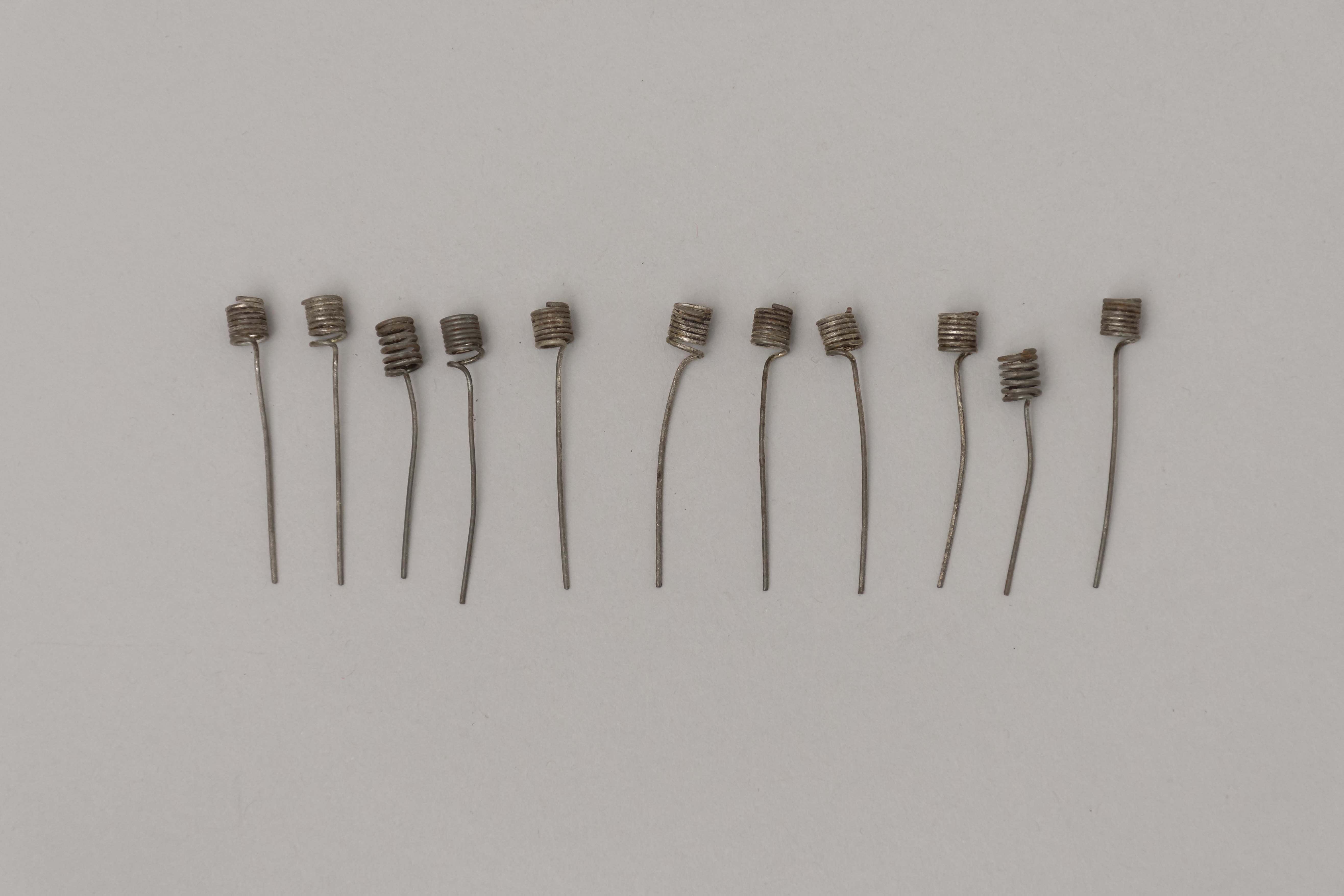
- Set of eleven candle holders. They are made of wire, coiled on one end to hold a birthday candle and with approximately one inch of straight wire to insert into the cake.
- Object History
- This item belonged to the owner of Stewart's Cartage & Fuel Supply (1910-1978) on 3870 East Hastings and lived at 3902 Albert Street, Burnaby. He was involved in local politics in Burnaby North, as well as the North Burnaby Board of Trade and the Joint Community Ratepayers Association.
- Category
- 08. Communication Artifacts
- Classification
- Ceremonial Artifacts - - Party Accessories
- Object Term
- Candle, Cake
- Decoration, Cake
- Subjects
- Celebrations - Birthdays
- Celebrations
- Historic Neighbourhood
- Alta Vista (Historic Neighbourhood)
- Planning Study Area
- Clinton-Glenwood Area
Images
card of pins
https://search.heritageburnaby.ca/link/museumartifact39843
- Repository
- Burnaby Village Museum
- Accession Code
- BV999.17.18
- Description
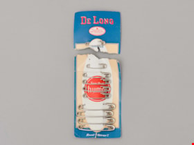
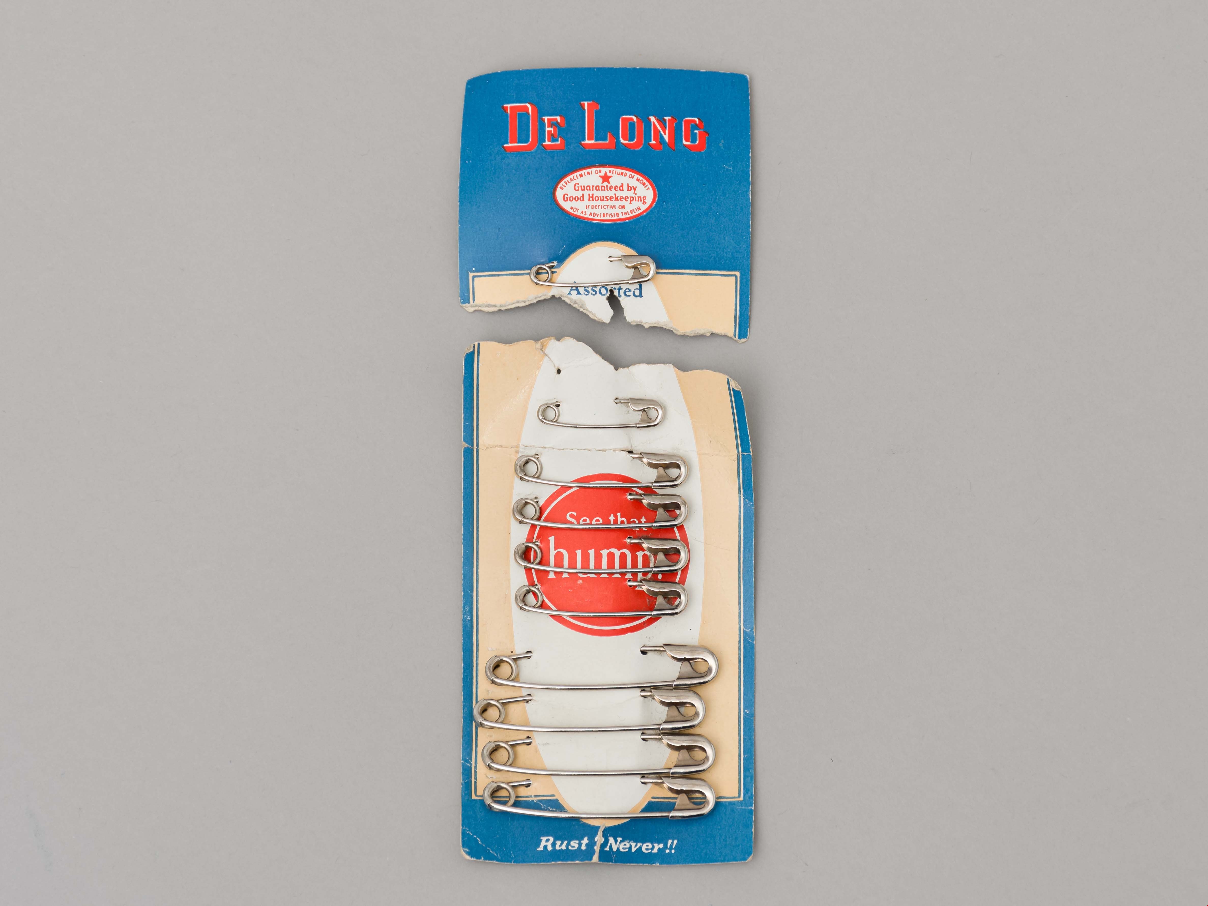
- Card of safety pins, torn off at top; blue border, ivory border, white oval has red circle in centre and printed in white is "See that Hump", printed at lower edge "Rust? Never!!"; 9 pins on card, 3 sizes; on reverse is list of other products available; torn-off part has red, blue printing "De Long", "Guaranteed by Good Housekeeping" seal; one pin attached; "Assorted"; ivory border corners and top of white oval at torn edge; other products noted on reverse side; c. 1940s
- Object History
- Owner of artifact Harry Charles Cutress was a longtime resident of Burnaby who was a volunteer member of Burnaby ARP.
- Category
- 04.Tools & Equipment for Materials
- Classification
- Textileworking T&E - - Needleworking Equipment
- Object Term
- Pin, Safety
- Historic Neighbourhood
- Alta Vista (Historic Neighbourhood)
- Planning Study Area
- Clinton-Glenwood Area
Images
![Car in Driveway, [ca. 1950] (date of original), copied 1991 thumbnail](/media/hpo/_Data/_Archives_Images/_Unrestricted/370/370-670.jpg?width=280)
Car in Driveway
https://search.heritageburnaby.ca/link/archivedescription38083
- Repository
- City of Burnaby Archives
- Date
- [ca. 1950] (date of original), copied 1991
- Collection/Fonds
- Burnaby Historical Society fonds
- Description Level
- Item
- Physical Description
- 1 photograph : b&w ; 2.9 x 4.8 cm print on contact sheet 20.2 x 26.2 cm
- Scope and Content
- Photograph of a car parked in the driveway at the back of 2337 Waverley Avenue (later renumbered 6926 Waverley Avenue).
- Repository
- City of Burnaby Archives
- Date
- [ca. 1950] (date of original), copied 1991
- Collection/Fonds
- Burnaby Historical Society fonds
- Subseries
- Burnaby Image Bank subseries
- Physical Description
- 1 photograph : b&w ; 2.9 x 4.8 cm print on contact sheet 20.2 x 26.2 cm
- Description Level
- Item
- Record No.
- 370-670
- Access Restriction
- No restrictions
- Reproduction Restriction
- No restrictions
- Accession Number
- BHS1999-03
- Scope and Content
- Photograph of a car parked in the driveway at the back of 2337 Waverley Avenue (later renumbered 6926 Waverley Avenue).
- Subjects
- Transportation - Automobiles
- Media Type
- Photograph
- Notes
- Title based on contents of photograph
- 1 b&w copy negative accompanying
- Negative has a pink cast
- Geographic Access
- Waverley Avenue
- Street Address
- 6926 Waverley Avenue
- Historic Neighbourhood
- Alta-Vista (Historic Neighbourhood)
- Planning Study Area
- Sussex-Nelson Area
Images
![Car in Driveway, [ca. 1950] (date of original), copied 1991 thumbnail](/media/hpo/_Data/_Archives_Images/_Unrestricted/370/370-670.jpg)
![Children playing in a sand pile, [1920] (date of original), copied 1986 thumbnail](/media/hpo/_Data/_Archives_Images/_Unrestricted/204/204-354.jpg?width=280)
Children playing in a sand pile
https://search.heritageburnaby.ca/link/archivedescription35496
- Repository
- City of Burnaby Archives
- Date
- [1920] (date of original), copied 1986
- Collection/Fonds
- Burnaby Historical Society fonds
- Description Level
- Item
- Physical Description
- 1 photograph : b&w ; 12.7 x 17.8 cm print
- Scope and Content
- Photograph of children playing in a sand pile at the end of Patrick Street, in Buller Ravine (John Matthews Ravine Park). Identified: (2nd from left) Evelyn Hardy (later Evelyn Le Grove). The others are Quinn children, neighbourhood friends of the Hardies. Evelyn was the daughter of Marie and Archi…
- Repository
- City of Burnaby Archives
- Date
- [1920] (date of original), copied 1986
- Collection/Fonds
- Burnaby Historical Society fonds
- Subseries
- Pioneer Tales subseries
- Physical Description
- 1 photograph : b&w ; 12.7 x 17.8 cm print
- Description Level
- Item
- Record No.
- 204-354
- Access Restriction
- No restrictions
- Reproduction Restriction
- No known restrictions
- Accession Number
- BHS1988-03
- Scope and Content
- Photograph of children playing in a sand pile at the end of Patrick Street, in Buller Ravine (John Matthews Ravine Park). Identified: (2nd from left) Evelyn Hardy (later Evelyn Le Grove). The others are Quinn children, neighbourhood friends of the Hardies. Evelyn was the daughter of Marie and Archie Hardie, who lived on McKee Street.
- Names
- Le Grove, Evelyn Hardy
- Media Type
- Photograph
- Notes
- Title based on contents of photograph
- Geographic Access
- John Matthews Creek Ravine Park
- Patrick Street
- Historic Neighbourhood
- Alta-Vista (Historic Neighbourhood)
- Planning Study Area
- Clinton-Glenwood Area
Images
![Children playing in a sand pile, [1920] (date of original), copied 1986 thumbnail](/media/hpo/_Data/_Archives_Images/_Unrestricted/204/204-354.jpg)

Clearing Gough Family Lot
https://search.heritageburnaby.ca/link/archivedescription35486
- Repository
- City of Burnaby Archives
- Date
- 1912 (date of original), copied 1986
- Collection/Fonds
- Burnaby Historical Society fonds
- Description Level
- Item
- Physical Description
- 1 photograph : b&w ; 12.7 x 17.8 cm print
- Scope and Content
- Photograph of the Gough family and relatives clearing the lot for the family home on Nelson Avenue, Alta Vista. Identified in the photo (back row, centre) Donald Gough. Others in picture are aunts and uncles named Evans. Donald was the son of Agnes Gough and her husband William, who settled here…
- Repository
- City of Burnaby Archives
- Date
- 1912 (date of original), copied 1986
- Collection/Fonds
- Burnaby Historical Society fonds
- Subseries
- Pioneer Tales subseries
- Physical Description
- 1 photograph : b&w ; 12.7 x 17.8 cm print
- Description Level
- Item
- Record No.
- 204-344
- Access Restriction
- No restrictions
- Reproduction Restriction
- No known restrictions
- Accession Number
- BHS1988-03
- Scope and Content
- Photograph of the Gough family and relatives clearing the lot for the family home on Nelson Avenue, Alta Vista. Identified in the photo (back row, centre) Donald Gough. Others in picture are aunts and uncles named Evans. Donald was the son of Agnes Gough and her husband William, who settled here at 2119 Nelson Avenue (later 7126 Nelson Avenue).
- Subjects
- Land Clearing
- Names
- Evans Family
- Gough, Donald
- Media Type
- Photograph
- Notes
- Title based on contents of photograph
- Annotation at top of photograph reads, "Nelson & Victory Sts - 1912"
- Geographic Access
- Nelson Avenue
- Street Address
- 7126 Nelson Avenue
- Historic Neighbourhood
- Alta-Vista (Historic Neighbourhood)
- Planning Study Area
- Sussex-Nelson Area
Images


Clinton Elementary School
https://search.heritageburnaby.ca/link/archivedescription62697
- Repository
- City of Burnaby Archives
- Date
- September 8, 2009
- Collection/Fonds
- Community Heritage Commission Special Projects fonds
- Description Level
- Item
- Physical Description
- 1 photograph (tiff) : col. ; 600 ppi
- Scope and Content
- Photograph of Clinton Elementary School.
- Repository
- City of Burnaby Archives
- Date
- September 8, 2009
- Collection/Fonds
- Community Heritage Commission Special Projects fonds
- Physical Description
- 1 photograph (tiff) : col. ; 600 ppi
- Description Level
- Item
- Record No.
- 503-030
- Access Restriction
- No restrictions
- Reproduction Restriction
- No restrictions
- Accession Number
- 2009-10
- Scope and Content
- Photograph of Clinton Elementary School.
- Subjects
- Buildings - Schools
- Media Type
- Photograph
- Photographer
- Pasch, Rebecca
- Notes
- Title based on contents of photograph
- Geographic Access
- Clinton Street
- Street Address
- 5858 Clinton Street
- Historic Neighbourhood
- Alta-Vista (Historic Neighbourhood)
- Planning Study Area
- Clinton-Glenwood Area
Images


Clinton Elementary School
https://search.heritageburnaby.ca/link/archivedescription79609
- Repository
- City of Burnaby Archives
- Date
- September 22, 1976
- Collection/Fonds
- Burnaby Public Library Contemporary Visual Archive Project
- Description Level
- Item
- Physical Description
- 1 photograph : b&w ; 11 x 16 cm mounted on cardboard
- Scope and Content
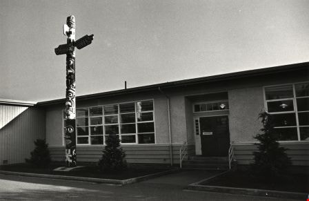
- Photograph of the Clinton Elementary School, 5858 Clinton Street, at the corner of Buller Avenue. A totem pole is located at the front entrance.
- Repository
- City of Burnaby Archives
- Date
- September 22, 1976
- Collection/Fonds
- Burnaby Public Library Contemporary Visual Archive Project
- Physical Description
- 1 photograph : b&w ; 11 x 16 cm mounted on cardboard
- Description Level
- Item
- Record No.
- 556-352
- Access Restriction
- No restrictions
- Reproduction Restriction
- Reproduce for fair dealing purposes only
- Accession Number
- 2013-13
- Scope and Content
- Photograph of the Clinton Elementary School, 5858 Clinton Street, at the corner of Buller Avenue. A totem pole is located at the front entrance.
- Media Type
- Photograph
- Photographer
- Ross, Martha
- Notes
- Scope note taken directly from BPL photograph description.
- 1 b&w copy negative : 10 x 12.5 cm accompanying
- Geographic Access
- Clinton Street
- Street Address
- 5858 Clinton Street
- Historic Neighbourhood
- Alta-Vista (Historic Neighbourhood)
- Planning Study Area
- Clinton-Glenwood Area
Images

Clinton Elementary School Playground
https://search.heritageburnaby.ca/link/archivedescription79611
- Repository
- City of Burnaby Archives
- Date
- September 22, 1976
- Collection/Fonds
- Burnaby Public Library Contemporary Visual Archive Project
- Description Level
- Item
- Physical Description
- 1 photograph : b&w ; 11 x 16 cm mounted on cardboard
- Scope and Content
- Photograph shows the playground at Clinton Elementary School, 5858 Clinton Street.
- Repository
- City of Burnaby Archives
- Date
- September 22, 1976
- Collection/Fonds
- Burnaby Public Library Contemporary Visual Archive Project
- Physical Description
- 1 photograph : b&w ; 11 x 16 cm mounted on cardboard
- Description Level
- Item
- Record No.
- 556-353
- Access Restriction
- No restrictions
- Reproduction Restriction
- Reproduce for fair dealing purposes only
- Accession Number
- 2013-13
- Scope and Content
- Photograph shows the playground at Clinton Elementary School, 5858 Clinton Street.
- Media Type
- Photograph
- Photographer
- Ross, Martha
- Notes
- Scope note taken directly from BPL photograph description.
- 1 b&w copy negative : 10 x 12.5 cm accompanying
- Geographic Access
- Clinton Street
- Street Address
- 5858 Clinton Street
- Historic Neighbourhood
- Alta-Vista (Historic Neighbourhood)
- Planning Study Area
- Clinton-Glenwood Area
Images

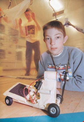
Clinton Elementary student with "Mars Rover"
https://search.heritageburnaby.ca/link/archivedescription98076
- Repository
- City of Burnaby Archives
- Date
- [1999]
- Collection/Fonds
- Burnaby NewsLeader photograph collection
- Description Level
- Item
- Physical Description
- 1 photograph (tiff) : col.
- Scope and Content
- Photograph of grade six student Alex Mackinnon posing with a Mars Rover he made, with student Andrew Carne behind him, at Clinton Elementary School.
- Repository
- City of Burnaby Archives
- Date
- [1999]
- Collection/Fonds
- Burnaby NewsLeader photograph collection
- Physical Description
- 1 photograph (tiff) : col.
- Description Level
- Item
- Record No.
- 535-3156
- Access Restriction
- No restrictions
- Reproduction Restriction
- No restrictions
- Accession Number
- 2018-12
- Scope and Content
- Photograph of grade six student Alex Mackinnon posing with a Mars Rover he made, with student Andrew Carne behind him, at Clinton Elementary School.
- Subjects
- Persons - Students
- Buildings - Schools
- Media Type
- Photograph
- Photographer
- Bartel, Mario
- Notes
- Title based on caption
- Collected by editorial for use in an April 1999 issue of the Burnaby NewsLeader
- Caption from metadata: "Alex Mackinnon, 11, a Grade 6 student at Clinton Elementary, shows off his Mars Rover, in the safety of one of the "life support habitats" built in the gym. Andrew Carne is on the outside, looking in."
- Geographic Access
- Clinton Street
- Street Address
- 5858 Clinton Street
- Historic Neighbourhood
- Alta Vista (Historic Neighbourhood)
- Planning Study Area
- Clinton-Glenwood Area
Images

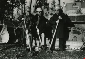
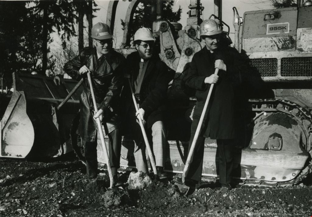
Construction of the St. Michael's Centre
https://search.heritageburnaby.ca/link/archivedescription45354
- Repository
- City of Burnaby Archives
- Date
- January 1980
- Collection/Fonds
- Columbian Newspaper collection
- Description Level
- Item
- Physical Description
- 1 photograph : b&w ; 16.5 x 24 cm
- Scope and Content
- Photograph of Reverend George Morrison of the United Church, Reverend Donald Grayson of the Anglican Church, and Father Dennis Luterback of the Catholic Church with hard hats on and shovels in their hands. They were participating in the sod turning ceremony for the then new combined care facility f…
- Repository
- City of Burnaby Archives
- Date
- January 1980
- Collection/Fonds
- Columbian Newspaper collection
- Physical Description
- 1 photograph : b&w ; 16.5 x 24 cm
- Description Level
- Item
- Record No.
- 480-249
- Access Restriction
- No restrictions
- Reproduction Restriction
- Reproduce for fair dealing purposes only
- Accession Number
- 2003-02
- Scope and Content
- Photograph of Reverend George Morrison of the United Church, Reverend Donald Grayson of the Anglican Church, and Father Dennis Luterback of the Catholic Church with hard hats on and shovels in their hands. They were participating in the sod turning ceremony for the then new combined care facility for seniors being built by St. Michael's Centre Society in South Burnaby.
- Names
- St. Michael's Centre Extended Care and Hospice Facility
- Morrison, Reverend George
- Grayson, Reverend Donald
- Luterback, Father Dennis
- Media Type
- Photograph
- Notes
- Title based on contents of photograph
- Newspaper clipping attached to verso of photograph reads: "DIGGING IN ... Sod turning ceremony for new 80-bed combined care facility for seniors being built by St. Michael's Centre Society was held recently. Participating in ceremony were, from left to right, Rev. George Morrison of United Church, Rev. Donald Grayson of Anglican Church, and Father Dennis Luterback of Catholic Church."
- Geographic Access
- Sussex Avenue
- Street Address
- 7451 Sussex Avenue
- Historic Neighbourhood
- Alta-Vista (Historic Neighbourhood)
- Planning Study Area
- Sussex-Nelson Area
Images

Corner of Nelson and Patrick
https://search.heritageburnaby.ca/link/archivedescription79695
- Repository
- City of Burnaby Archives
- Date
- September 27, 1976
- Collection/Fonds
- Burnaby Public Library Contemporary Visual Archive Project
- Description Level
- Item
- Physical Description
- 1 photograph : b&w ; 11 x 16 cm mounted on cardboard
- Scope and Content
- Photograph shows young children on the corner of Nelson Avenue and Patrick Place.
- Repository
- City of Burnaby Archives
- Date
- September 27, 1976
- Collection/Fonds
- Burnaby Public Library Contemporary Visual Archive Project
- Physical Description
- 1 photograph : b&w ; 11 x 16 cm mounted on cardboard
- Description Level
- Item
- Record No.
- 556-389
- Access Restriction
- No restrictions
- Reproduction Restriction
- Reproduce for fair dealing purposes only
- Accession Number
- 2013-13
- Scope and Content
- Photograph shows young children on the corner of Nelson Avenue and Patrick Place.
- Media Type
- Photograph
- Photographer
- Ross, Martha
- Notes
- Scope note taken directly from BPL photograph description.
- 1 b&w copy negative : 10 x 12.5 cm accompanying
- Geographic Access
- Nelson Avenue
- Patrick Place
- Historic Neighbourhood
- Alta-Vista (Historic Neighbourhood)
- Planning Study Area
- Sussex-Nelson Area
Images


Crossing Royal Oak & Rumble Street
https://search.heritageburnaby.ca/link/archivedescription93686
- Repository
- City of Burnaby Archives
- Date
- May 19, 1978
- Collection/Fonds
- Burnaby Public Library Contemporary Visual Archive Project
- Description Level
- Item
- Physical Description
- 1 photograph : b&w ; 12.5 x 17.5 cm
- Scope and Content
- Photograph of the intersection of Royal Oak Avenue and Rumble Street. Cars and pedestrians are crossing the intersection, and the signs for businesses TD Bank, Standard Oil/Chevron gas station, Gulf gas station, and Baxter's Market are visible. The photograph is taken from a corner of the intersect…
- Repository
- City of Burnaby Archives
- Date
- May 19, 1978
- Collection/Fonds
- Burnaby Public Library Contemporary Visual Archive Project
- Physical Description
- 1 photograph : b&w ; 12.5 x 17.5 cm
- Description Level
- Item
- Record No.
- 556-643
- Access Restriction
- No restrictions
- Reproduction Restriction
- Reproduce for fair dealing purposes only
- Accession Number
- 2017-57
- Scope and Content
- Photograph of the intersection of Royal Oak Avenue and Rumble Street. Cars and pedestrians are crossing the intersection, and the signs for businesses TD Bank, Standard Oil/Chevron gas station, Gulf gas station, and Baxter's Market are visible. The photograph is taken from a corner of the intersection, facing southeast.
- Subjects
- Geographic Features - Roads
- Advertising Medium - Signs and Signboards
- Buildings - Commercial - Service Stations
- Transportation - Automobiles
- Buildings - Commercial
- Media Type
- Photograph
- Photographer
- van Mannen, Mark
- Notes
- Title taken from project information form
- Accompanied by a project information form and 1 photograph (b&w negative ; 9.5 x 12.5 cm)
- BPL no. 91
- Geographic Access
- Royal Oak Avenue
- Rumble Street
- Historic Neighbourhood
- Alta Vista (Historic Neighbourhood)
- Planning Study Area
- Sussex-Nelson Area
Images


Crossing Royal Oak & Rumble Street
https://search.heritageburnaby.ca/link/archivedescription93687
- Repository
- City of Burnaby Archives
- Date
- May 19, 1978
- Collection/Fonds
- Burnaby Public Library Contemporary Visual Archive Project
- Description Level
- Item
- Physical Description
- 1 photograph : b&w ; 12.5 x 17.5 cm
- Scope and Content
- Photograph of the intersection of Royal Oak Avenue and Rumble Street. Cars and pedestrians are crossing the intersection, and the signs for businesses Grace United Pharmacy, Standard Oil/Chevron gas station, Gulf gas station, and Royal Meats are visible. The photograph is taken from the Gulf gas st…
- Repository
- City of Burnaby Archives
- Date
- May 19, 1978
- Collection/Fonds
- Burnaby Public Library Contemporary Visual Archive Project
- Physical Description
- 1 photograph : b&w ; 12.5 x 17.5 cm
- Description Level
- Item
- Record No.
- 556-644
- Access Restriction
- No restrictions
- Reproduction Restriction
- Reproduce for fair dealing purposes only
- Accession Number
- 2017-57
- Scope and Content
- Photograph of the intersection of Royal Oak Avenue and Rumble Street. Cars and pedestrians are crossing the intersection, and the signs for businesses Grace United Pharmacy, Standard Oil/Chevron gas station, Gulf gas station, and Royal Meats are visible. The photograph is taken from the Gulf gas station parking lot, facing northwest.
- Subjects
- Advertising Medium - Signs and Signboards
- Geographic Features - Roads
- Transportation - Automobiles
- Buildings - Commercial
- Buildings - Commercial - Service Stations
- Media Type
- Photograph
- Photographer
- van Mannen, Mark
- Notes
- Title taken from project information form
- Accompanied by a project information form and 1 photograph (b&w negative ; 9.5 x 12.5 cm)
- BPL no. 92
- Geographic Access
- Royal Oak Avenue
- Rumble Street
- Historic Neighbourhood
- Alta Vista (Historic Neighbourhood)
- Planning Study Area
- Sussex-Nelson Area
Images

![Diana Mumford, [2001] thumbnail](/media/hpo/_Data/_Archives_Images/_Unrestricted/535/535-2957.jpg?width=280)
Diana Mumford
https://search.heritageburnaby.ca/link/archivedescription97674
- Repository
- City of Burnaby Archives
- Date
- [2001]
- Collection/Fonds
- Burnaby NewsLeader photograph collection
- Description Level
- Item
- Physical Description
- 1 photograph (tiff) : col.
- Scope and Content
- Photograph of Diana Mumford, the co-chair of the Burnaby South Parent Advisory Committee, standing next to a row of portables at Burnaby South Secondary School.
- Repository
- City of Burnaby Archives
- Date
- [2001]
- Collection/Fonds
- Burnaby NewsLeader photograph collection
- Physical Description
- 1 photograph (tiff) : col.
- Description Level
- Item
- Record No.
- 535-2957
- Access Restriction
- No restrictions
- Reproduction Restriction
- No restrictions
- Accession Number
- 2018-12
- Scope and Content
- Photograph of Diana Mumford, the co-chair of the Burnaby South Parent Advisory Committee, standing next to a row of portables at Burnaby South Secondary School.
- Subjects
- Buildings - Schools
- Persons - Volunteers
- Media Type
- Photograph
- Photographer
- Bartel, Mario
- Notes
- Title based on caption
- Collected by editorial for use in a November 2001 issue of the Burnaby NewsLeader
- Caption from metadata: "Diana Mumford, the co-chair of the Burnaby South Parent Advisory Committee, in the middle of the school's portable alley."
- Geographic Access
- Rumble Street
- Street Address
- 5455 Rumble Street
- Historic Neighbourhood
- Alta Vista (Historic Neighbourhood)
- Planning Study Area
- Clinton-Glenwood Area
Images
![Diana Mumford, [2001] thumbnail](/media/hpo/_Data/_Archives_Images/_Unrestricted/535/535-2957.jpg)
![Diana Mumford at school crossing, [2000] thumbnail](/media/hpo/_Data/_Archives_Images/_Unrestricted/535/535-2867.jpg?width=280)
Diana Mumford at school crossing
https://search.heritageburnaby.ca/link/archivedescription97528
- Repository
- City of Burnaby Archives
- Date
- [2000]
- Collection/Fonds
- Burnaby NewsLeader photograph collection
- Description Level
- Item
- Physical Description
- 1 photograph (tiff) : col.
- Scope and Content
- Photograph of Diana Mumford standing on the shoulder of Rumble Street beside a school zone sign, in front of the Suncrest Elementary fences.
- Repository
- City of Burnaby Archives
- Date
- [2000]
- Collection/Fonds
- Burnaby NewsLeader photograph collection
- Physical Description
- 1 photograph (tiff) : col.
- Description Level
- Item
- Record No.
- 535-2867
- Access Restriction
- No restrictions
- Reproduction Restriction
- No restrictions
- Accession Number
- 2018-12
- Scope and Content
- Photograph of Diana Mumford standing on the shoulder of Rumble Street beside a school zone sign, in front of the Suncrest Elementary fences.
- Media Type
- Photograph
- Photographer
- Bartel, Mario
- Notes
- Title based on caption
- Collected by editorial for use in an October 2000 issue of the Burnaby NewsLeader
- Caption from metadata: "Diana Mumford is upset at the lack of sidewalks and safe bus stops along Rumble St. The north side of the street at Suncrest Elementary has speed zone signs, but no sidewalks along which children can safely walk to the school."
- Geographic Access
- Rumble Street
- Street Address
- 3883 Rumble Street
- Historic Neighbourhood
- Alta Vista (Historic Neighbourhood)
- Planning Study Area
- Suncrest Area
Images
![Diana Mumford at school crossing, [2000] thumbnail](/media/hpo/_Data/_Archives_Images/_Unrestricted/535/535-2867.jpg)
![Digney Pee-Wee Bowling League, [1958 or 1959] thumbnail](/media/hpo/_Data/_Archives_Images/_Unrestricted/559/562-001.jpg?width=280)
Digney Pee-Wee Bowling League
https://search.heritageburnaby.ca/link/archivedescription85072
- Repository
- City of Burnaby Archives
- Date
- [1958 or 1959]
- Collection/Fonds
- Digney Family fonds
- Description Level
- Item
- Physical Description
- 1 photograph : b&w ; 40.5 x 104 cm
- Scope and Content
- Panorama photograph of the Digney Pee-Wee Bowling League. Some members are identified as; Ernest Frank "Dig" Digney (back row- far left); Natasha Wiebe (back row-2nd from left); Carol Loew; Cathy Strang; Susan Dunham; Lynne Pemble; Leah Pemble; Karen Proby and Bruce Digney (front row-6th from the …
- Repository
- City of Burnaby Archives
- Date
- [1958 or 1959]
- Collection/Fonds
- Digney Family fonds
- Physical Description
- 1 photograph : b&w ; 40.5 x 104 cm
- Description Level
- Item
- Record No.
- 562-001
- Access Restriction
- No restrictions
- Reproduction Restriction
- No restrictions
- Accession Number
- 2014-09
- Scope and Content
- Panorama photograph of the Digney Pee-Wee Bowling League. Some members are identified as; Ernest Frank "Dig" Digney (back row- far left); Natasha Wiebe (back row-2nd from left); Carol Loew; Cathy Strang; Susan Dunham; Lynne Pemble; Leah Pemble; Karen Proby and Bruce Digney (front row-6th from the left). Andy Digney opened the Digney Bowl on August 19, 1955 and passed the business onto his son Ernest who ran it until his son Bruce Digney took over in 1980. The Digney Bowl was located at 6521 Bonsor Avenue. The bowling league met every Saturday morning at the Digney bowling alley where there were a total of 32 teams (5 children per team) who bowled in shifts since there wasn't enough room for everyone to bowl at once. Paul Digney (the son of Dig Digney) helped out by emptying ashtrays.
- Subjects
- Sports - Bowling
- Names
- Digney Bowling Alley
- Digney, Ernest Frank "Dig"
- Wiebe, Natasha
- Loew, Carol
- Strang, Cathy
- Dunham, Susan
- Pemble, Lynne
- Proby, Karen
- Digney, Bruce
- Digney, Paul
- Media Type
- Photograph
- Notes
- Transcribed title
- Geographic Access
- Bonsor Avenue
- Historic Neighbourhood
- Alta-Vista (Historic Neighbourhood)
- Planning Study Area
- Sussex-Nelson Area
Images
![Digney Pee-Wee Bowling League, [1958 or 1959] thumbnail](/media/hpo/_Data/_Archives_Images/_Unrestricted/559/562-001.jpg)
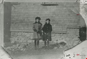
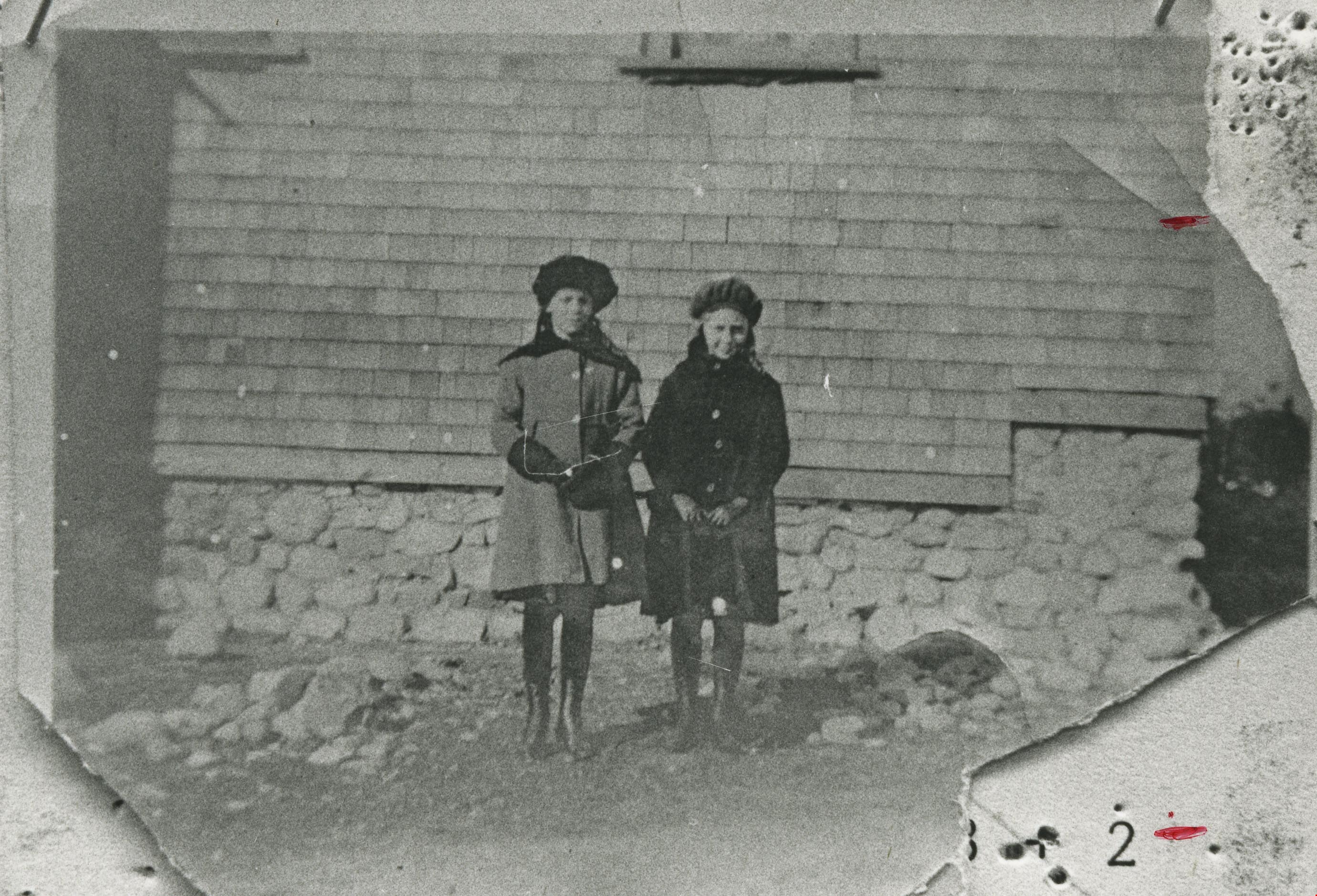
Doris Armitage and Phyllis Fisher
https://search.heritageburnaby.ca/link/archivedescription35473
- Repository
- City of Burnaby Archives
- Date
- 1920 (date of original), copied 1986
- Collection/Fonds
- Burnaby Historical Society fonds
- Description Level
- Item
- Physical Description
- 1 photograph : b&w ; 12.7 x 17.8 cm print
- Scope and Content
- Photograph of (left) Doris Armitage (later Doris Chadsey) and (right) Phyllis Fisher, in front of the Armitage family home, 4565 Portland Street, Alta Vista. Doris' father, Alfred Armitage, built the house himself. The foundation was built with boulders and rocks cleared from the property.
- Repository
- City of Burnaby Archives
- Date
- 1920 (date of original), copied 1986
- Collection/Fonds
- Burnaby Historical Society fonds
- Subseries
- Pioneer Tales subseries
- Physical Description
- 1 photograph : b&w ; 12.7 x 17.8 cm print
- Description Level
- Item
- Record No.
- 204-331
- Access Restriction
- No restrictions
- Reproduction Restriction
- No known restrictions
- Accession Number
- BHS1988-03
- Scope and Content
- Photograph of (left) Doris Armitage (later Doris Chadsey) and (right) Phyllis Fisher, in front of the Armitage family home, 4565 Portland Street, Alta Vista. Doris' father, Alfred Armitage, built the house himself. The foundation was built with boulders and rocks cleared from the property.
- Media Type
- Photograph
- Notes
- Title based on contents of photograph
- Geographic Access
- Portland Street
- Street Address
- 4565 Portland Street
- Historic Neighbourhood
- Alta-Vista (Historic Neighbourhood)
- Planning Study Area
- Clinton-Glenwood Area
Images
![Dr. Jim Grant at St. Michael's Centre, [2002] thumbnail](/media/hpo/_Data/_Archives_Images/_Unrestricted/535/535-3039.jpg?width=280)
Dr. Jim Grant at St. Michael's Centre
https://search.heritageburnaby.ca/link/archivedescription97787
- Repository
- City of Burnaby Archives
- Date
- [2002]
- Collection/Fonds
- Burnaby NewsLeader photograph collection
- Description Level
- Item
- Physical Description
- 1 photograph (tiff) : col.
- Scope and Content
- Photograph of Dr. Jim Grant, the chair of St. Michael's Centre's fundraising campaign, posing outside of the Centre.
- Repository
- City of Burnaby Archives
- Date
- [2002]
- Collection/Fonds
- Burnaby NewsLeader photograph collection
- Physical Description
- 1 photograph (tiff) : col.
- Description Level
- Item
- Record No.
- 535-3039
- Access Restriction
- No restrictions
- Reproduction Restriction
- No restrictions
- Accession Number
- 2018-12
- Scope and Content
- Photograph of Dr. Jim Grant, the chair of St. Michael's Centre's fundraising campaign, posing outside of the Centre.
- Media Type
- Photograph
- Photographer
- Bartel, Mario
- Notes
- Title based on caption
- Collected by editorial for use in a December 2002 issue of the Burnaby NewsLeader
- Caption from metadata: "Dr. Jim Grant is the chair of St. Michael's capital campaign to raise funds for a new 16-bed hospice unit, Burnaby's first, to be built at the Seniors' care centre."
- Geographic Access
- Sussex Avenue
- Street Address
- 7451 Sussex Avenue
- Historic Neighbourhood
- Alta Vista (Historic Neighbourhood)
- Planning Study Area
- Sussex-Nelson Area
Images
![Dr. Jim Grant at St. Michael's Centre, [2002] thumbnail](/media/hpo/_Data/_Archives_Images/_Unrestricted/535/535-3039.jpg)
![Dundonald United Church, [between 1911 and 1919] thumbnail](/media/hpo/_Data/_Archives_Images/_Unrestricted/316/325-022.jpg?width=280)
Dundonald United Church
https://search.heritageburnaby.ca/link/archivedescription37150
- Repository
- City of Burnaby Archives
- Date
- [between 1911 and 1919]
- Collection/Fonds
- Burnaby Historical Society fonds
- Description Level
- Item
- Physical Description
- 1 photograph : b&w ; 8.5 x 12.5 cm print
- Scope and Content
- Photograph of Dundonald United Church, taken from the school grounds of Riverway East (later renamed Dundonald School).
- Repository
- City of Burnaby Archives
- Date
- [between 1911 and 1919]
- Collection/Fonds
- Burnaby Historical Society fonds
- Subseries
- Disney family subseries
- Physical Description
- 1 photograph : b&w ; 8.5 x 12.5 cm print
- Description Level
- Item
- Record No.
- 325-022
- Access Restriction
- No restrictions
- Reproduction Restriction
- No known restrictions
- Accession Number
- BHS1996-04
- Scope and Content
- Photograph of Dundonald United Church, taken from the school grounds of Riverway East (later renamed Dundonald School).
- Subjects
- Buildings - Religious - Churches
- Media Type
- Photograph
- Photographer
- Disney, John Harold "Jack"
- Notes
- Title based on contents of photograph
- Geographic Access
- Marine Drive
- Clinton Street
- Gilley Avenue
- Curragh Avenue
- Historic Neighbourhood
- Alta-Vista (Historic Neighbourhood)
- Planning Study Area
- Clinton-Glenwood Area
Images
![Dundonald United Church, [between 1911 and 1919] thumbnail](/media/hpo/_Data/_Archives_Images/_Unrestricted/316/325-022.jpg)
![Earthquake preparedness at Nelson Avenue School, [2001] thumbnail](/media/hpo/_Data/_Archives_Images/_Unrestricted/535/535-1650-2.jpg?width=280)
Earthquake preparedness at Nelson Avenue School
https://search.heritageburnaby.ca/link/archivedescription95849
- Repository
- City of Burnaby Archives
- Date
- [2001]
- Collection/Fonds
- Burnaby NewsLeader photograph collection
- Description Level
- File
- Physical Description
- 2 photographs (tiff) : col.
- Scope and Content
- File contains photographs of students at Nelson Avenue School presenting and learning about their earthquake preparedness supplies.
- Repository
- City of Burnaby Archives
- Date
- [2001]
- Collection/Fonds
- Burnaby NewsLeader photograph collection
- Physical Description
- 2 photographs (tiff) : col.
- Description Level
- File
- Record No.
- 535-1650
- Access Restriction
- No restrictions
- Reproduction Restriction
- No restrictions
- Accession Number
- 2018-12
- Scope and Content
- File contains photographs of students at Nelson Avenue School presenting and learning about their earthquake preparedness supplies.
- Subjects
- Persons - Students
- Buildings - Schools
- Names
- Nelson Avenue School
- Media Type
- Photograph
- Photographer
- Ponne, Simone
- Notes
- Title based on original file name
- Collected by editorial for use in a March 2001 issue of the Burnaby NewsLeader
- Caption from metadata: "Nelson elementary"
- Geographic Access
- Irmin Street
- Street Address
- 4850 Irmin Street
- Historic Neighbourhood
- Alta Vista (Historic Neighbourhood)
- Planning Study Area
- Sussex-Nelson Area
Images
![Earthquake preparedness at Nelson Avenue School, [2001] thumbnail](/media/hpo/_Data/_Archives_Images/_Unrestricted/535/535-1650-2.jpg)