Narrow Results By
Creator
- Bailey, Robert 1
- Bartel, Mario 48
- Battistoni, Peter 1
- Burnaby Village Museum 1
- Canadian Broadcasting Corporation 1
- Code, Norah 4
- Commercial Illustrators Industrial Photographers 1
- Cooksley, William Thomas 1
- Flanagan, Colleen 1
- George Allen Aerial Photos Limited 3
- Hodge, Craig 1
- Hunting Survey Corporation Limited 2
Person / Organization
- 5th Burnaby Brownie Pack 1
- A & H Plastering and Stucco 1
- Bailey, Robert 1
- Barnes, Hannah Victoria "Girlie" Love 9
- BC Society of Model Engineers (BCSME) 1
- Bingham, Alfred "Alf" 1
- Boy Scouts of Canada 1
- Brandrith, Benjamin Jefferson "Ben" 3
- Brandrith, Martha Dorothy “Dot” Love 14
- British Columbia Electric Railway Company 2
- Burnaby Central Secondary School 1
- Burnaby Historical Society 4
![51st Annual Pacific Northwest Teen Square Dance Festival, [2000] thumbnail](/media/hpo/_Data/_Archives_Images/_Unrestricted/535/535-2397-1.jpg?width=280)
51st Annual Pacific Northwest Teen Square Dance Festival
https://search.heritageburnaby.ca/link/archivedescription96839
- Repository
- City of Burnaby Archives
- Date
- [2000]
- Collection/Fonds
- Burnaby NewsLeader photograph collection
- Description Level
- File
- Physical Description
- 2 photographs (tiff) : col.
- Scope and Content
- File contains photographs of competitors at the 51st Annual Pacific Northwest Teen Square Dance Festival, in the Chancellor's Gym at Simon Fraser University. Photographs depict two different dance couples, both in costume and in the midst of performing.
- Repository
- City of Burnaby Archives
- Date
- [2000]
- Collection/Fonds
- Burnaby NewsLeader photograph collection
- Physical Description
- 2 photographs (tiff) : col.
- Description Level
- File
- Record No.
- 535-2397
- Access Restriction
- No restrictions
- Reproduction Restriction
- No restrictions
- Accession Number
- 2018-12
- Scope and Content
- File contains photographs of competitors at the 51st Annual Pacific Northwest Teen Square Dance Festival, in the Chancellor's Gym at Simon Fraser University. Photographs depict two different dance couples, both in costume and in the midst of performing.
- Names
- Simon Fraser University
- Media Type
- Photograph
- Photographer
- Bartel, Mario
- Notes
- Title based on caption
- Collected by editorial for use in a May 2000 issue of the Burnaby NewsLeader
- Caption from metadata: "More than 300 young square dancers from BC, Washington and Oregon converged on Chacellor's Gym at SFU over the weekend to strut their stuff at the 51st Annual Pacific Northwest Teen Square Dance Festival."
- Geographic Access
- Burnaby Mountain Conservation Area
- University Drive
- Street Address
- 8888 University Drive
- Planning Study Area
- Burnaby Mountain Area
Images
![51st Annual Pacific Northwest Teen Square Dance Festival, [2000] thumbnail](/media/hpo/_Data/_Archives_Images/_Unrestricted/535/535-2397-1.jpg)
1958 Centennial Committee
https://search.heritageburnaby.ca/link/archivedescription55590
- Repository
- City of Burnaby Archives
- Date
- 1958
- Collection/Fonds
- John Shaw fonds
- Description Level
- Item
- Physical Description
- 1 photograph : col. slide (Munshaw) ; 7 x 7 cm
- Scope and Content
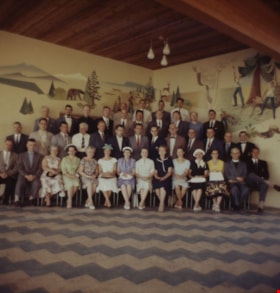
- Photograph of forty-one Burnaby Centennial Committee members at the Burnaby Centennial Pavilion on Burnaby Mountain. John Shaw, Municipal Clerk, can be seen in the second row from the front, 6th from the left and Reverend Faulkner is seated in the front row, second from the left. The rest are unide…
- Repository
- City of Burnaby Archives
- Date
- 1958
- Collection/Fonds
- John Shaw fonds
- Series
- Civil Service series
- Physical Description
- 1 photograph : col. slide (Munshaw) ; 7 x 7 cm
- Description Level
- Item
- Record No.
- 485-065
- Access Restriction
- No restrictions
- Reproduction Restriction
- Reproduce for fair dealing purposes only
- Accession Number
- 2005-15
- 2006-01
- 2007-18
- Scope and Content
- Photograph of forty-one Burnaby Centennial Committee members at the Burnaby Centennial Pavilion on Burnaby Mountain. John Shaw, Municipal Clerk, can be seen in the second row from the front, 6th from the left and Reverend Faulkner is seated in the front row, second from the left. The rest are unidentified.
- Media Type
- Photograph
- Notes
- Title based on contents of photograph
- Note on vero reads: "1958 Centennial Cmte. Burnaby Mtn"
- Geographic Access
- Burnaby Mountain Conservation Area
- Centennial Way
- Street Address
- 100 Centennial Way
- Planning Study Area
- Burnaby Mountain Area
Images


A. D. B. on top of Burnaby Mountain
https://search.heritageburnaby.ca/link/archivedescription66270
- Repository
- City of Burnaby Archives
- Date
- 1914
- Collection/Fonds
- Peers Family and Hill Family fonds
- Description Level
- Item
- Physical Description
- 1 photograph
- Scope and Content
- Photograph shows a young man sitting on stone in front of a few fallen trees and brush. A label accompanying the photograph reads: ADB - Top of Burnaby Mtn. - 1914.
- Repository
- City of Burnaby Archives
- Date
- 1914
- Collection/Fonds
- Peers Family and Hill Family fonds
- Physical Description
- 1 photograph
- Description Level
- Item
- Record No.
- 477-982
- Access Restriction
- No restrictions
- Reproduction Restriction
- No known restrictions
- Accession Number
- 2007-12
- Scope and Content
- Photograph shows a young man sitting on stone in front of a few fallen trees and brush. A label accompanying the photograph reads: ADB - Top of Burnaby Mtn. - 1914.
- Media Type
- Photograph
- Notes
- Title based on contents of photograph
- Geographic Access
- Burnaby Mountain Conservation Area
- Planning Study Area
- Burnaby Mountain Area
Images

address panel
https://search.heritageburnaby.ca/link/museumartifact91313
- Repository
- Burnaby Village Museum
- Accession Code
- BV021.21.21
- Description
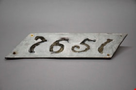
- The number "7651" are stenciled out across the panel, surrounded by gray paint. The panel itself is a diagonal rectangle (parallelogram) shaped sign. There are four screws, one in each corner, with two rusting screws still intact in both the bottom right and left corner. The reverse of the panel is yellowed, and was also painted gray.
- Object History
- Panel was found in the attic of Love Farmhouse August 2021, where it had been since the farmhouse restoration project in the late 1990's. This panel was an original fixture on the home.
- Category
- 08. Communication Artifacts
- Classification
- Documentary Artifacts - - Other Documents
- Object Term
- Address Label
- Colour
- Gray
- Measurements
- length: 46 cm width: 12.8 cm
- Country Made
- Canada
- Province Made
- British Columbia
- Site/City Made
- Burnaby
- Subjects
- Household Accessory
- Names
- Love Family
- Geographic Access
- Cumberland Street
- Historic Neighbourhood
- East Burnaby (Historic Neighbourhood)
Images

![Aerial map of Burnaby Mountain, [1995] thumbnail](/media/Hpo/_Data/_Archives_Images/_Unrestricted/629/629-006.jpg?width=280)
Aerial map of Burnaby Mountain
https://search.heritageburnaby.ca/link/archivedescription97805
- Repository
- City of Burnaby Archives
- Date
- [1995]
- Collection/Fonds
- Burnaby Mountain Preservation Society fonds
- Description Level
- Item
- Physical Description
- 1 photograph : col. slide ; 35 mm
- Scope and Content
- Aerial map of Burnaby Mountain.
- Repository
- City of Burnaby Archives
- Date
- [1995]
- Collection/Fonds
- Burnaby Mountain Preservation Society fonds
- Physical Description
- 1 photograph : col. slide ; 35 mm
- Description Level
- Item
- Record No.
- 629-006
- Access Restriction
- No restrictions
- Reproduction Restriction
- Reproduce for fair dealing purposes only
- Accession Number
- 2006-13
- Scope and Content
- Aerial map of Burnaby Mountain.
- Subjects
- Documentary Artifacts - Maps
- Media Type
- Photograph
- Geographic Access
- Burnaby Mountain Conservation Area
- Planning Study Area
- Burnaby Mountain Area
Images
![Aerial map of Burnaby Mountain, [1995] thumbnail](/media/Hpo/_Data/_Archives_Images/_Unrestricted/629/629-006.jpg)

Aerial of Simon Fraser University
https://search.heritageburnaby.ca/link/archivedescription97804
- Repository
- City of Burnaby Archives
- Date
- 1993
- Collection/Fonds
- Burnaby Mountain Preservation Society fonds
- Description Level
- Item
- Physical Description
- 1 photograph : col. slide ; 35 mm
- Scope and Content
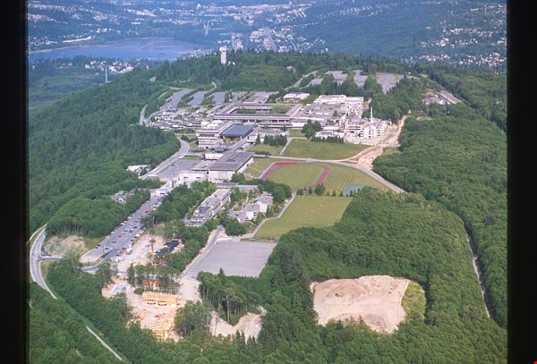
- Aerial photograph of SFU.
- Repository
- City of Burnaby Archives
- Date
- 1993
- Collection/Fonds
- Burnaby Mountain Preservation Society fonds
- Physical Description
- 1 photograph : col. slide ; 35 mm
- Description Level
- Item
- Record No.
- 629-005
- Access Restriction
- No restrictions
- Reproduction Restriction
- Reproduce for fair dealing purposes only
- Accession Number
- 2006-13
- Scope and Content
- Aerial photograph of SFU.
- Names
- Simon Fraser University
- Media Type
- Photograph
- Notes
- Handwritten notes on slide read: "SFU" and "May 23, 1993 Image #05812"; stamp on slide reads "Copyright Airphoto 85 All Rights Reserved (604) 946-6181."
- Geographic Access
- Burnaby Mountain Conservation Area
- Planning Study Area
- Burnaby Mountain Area
Images
Aerial photograph of Burnaby
https://search.heritageburnaby.ca/link/archivedescription84893
- Repository
- City of Burnaby Archives
- Date
- 1963
- Collection/Fonds
- Allan Amundsen collection
- Description Level
- Item
- Physical Description
- 1 photograph : b&w ; 22.5 x 22.5 cm
- Scope and Content
- Aerial photograph of Burnaby north of Lougheed Highway and west of Sperling Avenue.
- Repository
- City of Burnaby Archives
- Date
- 1963
- Collection/Fonds
- Allan Amundsen collection
- Physical Description
- 1 photograph : b&w ; 22.5 x 22.5 cm
- Description Level
- Item
- Record No.
- 561-014
- Access Restriction
- In Archives only
- Reproduction Restriction
- No reproduction permitted
- Accession Number
- 2014-08
- Scope and Content
- Aerial photograph of Burnaby north of Lougheed Highway and west of Sperling Avenue.
- Subjects
- Aerial Photographs
- Media Type
- Photograph
- Photographer
- Province of British Columbia
- Notes
- Title based on contents of photograph
- This photo is indentified as BC5061:119 and connects with B.C. air photograph BC5061:118 to the west and BC5061:120 to the east
- Geographic Access
- Burnaby Mountain Conservation Area
- Historic Neighbourhood
- Lozells (Historic Neighbourhood)
- Planning Study Area
- Sperling-Broadway Area
- Lake City Area
- Government Road Area
Aerial photograph of Burnaby
https://search.heritageburnaby.ca/link/archivedescription84894
- Repository
- City of Burnaby Archives
- Date
- 1963
- Collection/Fonds
- Allan Amundsen collection
- Description Level
- Item
- Physical Description
- 1 photograph : b&w ; 22.5 x 22.5 cm
- Scope and Content
- Aerial photograph of Burnaby north of Broadway and west of Sperling Avenue.
- Repository
- City of Burnaby Archives
- Date
- 1963
- Collection/Fonds
- Allan Amundsen collection
- Physical Description
- 1 photograph : b&w ; 22.5 x 22.5 cm
- Description Level
- Item
- Record No.
- 561-015
- Access Restriction
- In Archives only
- Reproduction Restriction
- No reproduction permitted
- Accession Number
- 2014-08
- Scope and Content
- Aerial photograph of Burnaby north of Broadway and west of Sperling Avenue.
- Subjects
- Aerial Photographs
- Media Type
- Photograph
- Photographer
- Province of British Columbia
- Notes
- Title based on contents of photograph
- This photo is indentified as BC5061:120 and connects with B.C. air photograph BC5061:119 to the west and BC5061:121 to the east
- Geographic Access
- Burnaby Mountain Conservation Area
- Historic Neighbourhood
- Lozells (Historic Neighbourhood)
- Planning Study Area
- Sperling-Broadway Area
- Lake City Area
- Government Road Area
- Burnaby Mountain Area
Aerial photograph of Burnaby
https://search.heritageburnaby.ca/link/archivedescription84896
- Repository
- City of Burnaby Archives
- Date
- 1963
- Collection/Fonds
- Allan Amundsen collection
- Description Level
- Item
- Physical Description
- 1 photograph : b&w ; 22.5 x 22.5 cm
- Scope and Content
- Aerial photograph of Burnaby north of Broadway and west of Sperling Avenue.
- Repository
- City of Burnaby Archives
- Date
- 1963
- Collection/Fonds
- Allan Amundsen collection
- Physical Description
- 1 photograph : b&w ; 22.5 x 22.5 cm
- Description Level
- Item
- Record No.
- 561-016
- Access Restriction
- In Archives only
- Reproduction Restriction
- No reproduction permitted
- Accession Number
- 2014-08
- Scope and Content
- Aerial photograph of Burnaby north of Broadway and west of Sperling Avenue.
- Subjects
- Aerial Photographs
- Media Type
- Photograph
- Photographer
- Province of British Columbia
- Notes
- Title based on contents of photograph
- This photo is indentified as BC5061:121 and connects with B.C. air photograph BC5061:120 to the west and BC5061:122 to the east
- Geographic Access
- Burnaby Mountain Conservation Area
- Historic Neighbourhood
- Lozells (Historic Neighbourhood)
- Planning Study Area
- Sperling-Broadway Area
- Lake City Area
- Government Road Area
- Burnaby Mountain Area
Aerial photograph of Burnaby Mountain
https://search.heritageburnaby.ca/link/archivedescription84882
- Repository
- City of Burnaby Archives
- Date
- 1963
- Collection/Fonds
- Allan Amundsen collection
- Description Level
- Item
- Physical Description
- 1 photograph : b&w ; 22.5 x 22.5 cm
- Scope and Content
- Aerial photograph of Burnaby Mountain and surrounding area with Burrard Inlet to the north.
- Repository
- City of Burnaby Archives
- Date
- 1963
- Collection/Fonds
- Allan Amundsen collection
- Physical Description
- 1 photograph : b&w ; 22.5 x 22.5 cm
- Description Level
- Item
- Record No.
- 561-003
- Access Restriction
- In Archives only
- Reproduction Restriction
- No reproduction permitted
- Accession Number
- 2014-08
- Scope and Content
- Aerial photograph of Burnaby Mountain and surrounding area with Burrard Inlet to the north.
- Media Type
- Photograph
- Photographer
- Province of British Columbia
- Notes
- Title based on contents of photograph
- This photo is indentified as BC5061:83 and connects with B.C. air photograph BC5061:84 to the west and BC5061:82 to the east
- Geographic Access
- Burrard Inlet
- Burnaby Mountain Conservation Area
- Historic Neighbourhood
- Barnet (Historic Neighbourhood)
- Lochdale (Historic Neighbourhood)
- Planning Study Area
- Westridge Area
- Burnaby Mountain Area
- Lake City Area
Aerial photograph of Burnaby Mountain
https://search.heritageburnaby.ca/link/archivedescription84883
- Repository
- City of Burnaby Archives
- Date
- 1963
- Collection/Fonds
- Allan Amundsen collection
- Description Level
- Item
- Physical Description
- 1 photograph : b&w ; 22.5 x 22.5 cm
- Scope and Content
- Aerial photograph of Burnaby Mountain and surrounding area with Burrard Inlet to the north.
- Repository
- City of Burnaby Archives
- Date
- 1963
- Collection/Fonds
- Allan Amundsen collection
- Physical Description
- 1 photograph : b&w ; 22.5 x 22.5 cm
- Description Level
- Item
- Record No.
- 561-004
- Access Restriction
- In Archives only
- Reproduction Restriction
- No reproduction permitted
- Accession Number
- 2014-08
- Scope and Content
- Aerial photograph of Burnaby Mountain and surrounding area with Burrard Inlet to the north.
- Media Type
- Photograph
- Photographer
- Province of British Columbia
- Notes
- Title based on contents of photograph
- This photo is indentified as BC5061:82 and connects with B.C. air photograph BC5061:83 to the west and BC5061:81 to the east.
- Geographic Access
- Burrard Inlet
- Burnaby Mountain Conservation Area
- Historic Neighbourhood
- Barnet (Historic Neighbourhood)
- Planning Study Area
- Burnaby Mountain Area
- Lake City Area
Aerial photograph of Burnaby Mountain
https://search.heritageburnaby.ca/link/archivedescription84884
- Repository
- City of Burnaby Archives
- Date
- 1963
- Collection/Fonds
- Allan Amundsen collection
- Description Level
- Item
- Physical Description
- 1 photograph : b&w ; 22.5 x 22.5 cm
- Scope and Content
- Aerial photograph of Burnaby Mountain and surrounding area with Burrard Inlet to the north.
- Repository
- City of Burnaby Archives
- Date
- 1963
- Collection/Fonds
- Allan Amundsen collection
- Physical Description
- 1 photograph : b&w ; 22.5 x 22.5 cm
- Description Level
- Item
- Record No.
- 561-005
- Access Restriction
- In Archives only
- Reproduction Restriction
- No reproduction permitted
- Accession Number
- 2014-08
- Scope and Content
- Aerial photograph of Burnaby Mountain and surrounding area with Burrard Inlet to the north.
- Media Type
- Photograph
- Photographer
- Province of British Columbia
- Notes
- Title based on contents of photograph
- This photo is indentified as BC5061:81 and connects with B.C. air photograph BC5061:82 to the west and BC5061:80 to the east.
- Geographic Access
- Burrard Inlet
- Burnaby Mountain Conservation Area
- Historic Neighbourhood
- Barnet (Historic Neighbourhood)
- Planning Study Area
- Burnaby Mountain Area
Aerial photograph of Burnaby Mountain
https://search.heritageburnaby.ca/link/archivedescription64460
- Repository
- City of Burnaby Archives
- Date
- [1957 or 1958]
- Collection/Fonds
- Burnaby Historical Society fonds
- Description Level
- Item
- Physical Description
- 1 photograph : b&w ; 14 x 14 cm
- Scope and Content
- Aerial photograph of the Burnaby Mountain park and Centennial Pavilion, under construction.
- Repository
- City of Burnaby Archives
- Date
- [1957 or 1958]
- Collection/Fonds
- Burnaby Historical Society fonds
- Subseries
- North Burnaby Board of Trade subseries
- Physical Description
- 1 photograph : b&w ; 14 x 14 cm
- Description Level
- Item
- Record No.
- 476-026
- Access Restriction
- No restrictions
- Reproduction Restriction
- Reproduce for fair dealing purposes only
- Accession Number
- BHS2005-8
- Scope and Content
- Aerial photograph of the Burnaby Mountain park and Centennial Pavilion, under construction.
- Subjects
- Aerial Photographs
- Land Clearing
- Media Type
- Photograph
- Photographer
- Hunting Survey Corporation Limited
- Notes
- Title based on contents of photograph
- Geographic Access
- Burnaby Mountain Conservation Area
- Centennial Way
- Street Address
- 100 Centennial Way
- Planning Study Area
- Burnaby Mountain Area
![Aerial photograph of Burnaby Mountain, [1957 or 1958] thumbnail](/media/hpo/_Data/_Archives_Images/_Unrestricted/371/476-024.jpg?width=280)
Aerial photograph of Burnaby Mountain
https://search.heritageburnaby.ca/link/archivedescription38681
- Repository
- City of Burnaby Archives
- Date
- [1957 or 1958]
- Collection/Fonds
- Burnaby Historical Society fonds
- Description Level
- Item
- Physical Description
- 1 photograph : b&w ; 19 x 24 cm
- Scope and Content
- Aerial photograph of Burnaby Mountain and the Centennial Pavilion, built to mark the 1958 centennial.
- Repository
- City of Burnaby Archives
- Date
- [1957 or 1958]
- Collection/Fonds
- Burnaby Historical Society fonds
- Subseries
- North Burnaby Board of Trade subseries
- Physical Description
- 1 photograph : b&w ; 19 x 24 cm
- Description Level
- Item
- Record No.
- 476-024
- Access Restriction
- No restrictions
- Reproduction Restriction
- Reproduce for fair dealing purposes only
- Accession Number
- BHS2005-8
- Scope and Content
- Aerial photograph of Burnaby Mountain and the Centennial Pavilion, built to mark the 1958 centennial.
- Subjects
- Aerial Photographs
- Media Type
- Photograph
- Photographer
- Rossmo, Nicholas
- Notes
- Title based on contents of photograph
- Geographic Access
- Burnaby Mountain Conservation Area
- Centennial Way
- Street Address
- 100 Centennial Way
- Planning Study Area
- Burnaby Mountain Area
Images
![Aerial photograph of Burnaby Mountain, [1957 or 1958] thumbnail](/media/hpo/_Data/_Archives_Images/_Unrestricted/371/476-024.jpg)
![Aerial photograph of Burnaby Mountain, [1957 or 1958] thumbnail](/media/hpo/_Data/_Archives_Images/_Unrestricted/371/476-025.jpg?width=280)
Aerial photograph of Burnaby Mountain
https://search.heritageburnaby.ca/link/archivedescription39742
- Repository
- City of Burnaby Archives
- Date
- [1957 or 1958]
- Collection/Fonds
- Burnaby Historical Society fonds
- Description Level
- Item
- Physical Description
- 1 photograph : b&w ; 14 x 14 cm
- Scope and Content
- Aerial photograph of the Burnaby Mountain park and Centennial Pavilion, under construction.
- Repository
- City of Burnaby Archives
- Date
- [1957 or 1958]
- Collection/Fonds
- Burnaby Historical Society fonds
- Subseries
- North Burnaby Board of Trade subseries
- Physical Description
- 1 photograph : b&w ; 14 x 14 cm
- Description Level
- Item
- Record No.
- 476-025
- Access Restriction
- No restrictions
- Reproduction Restriction
- Reproduce for fair dealing purposes only
- Accession Number
- BHS2005-8
- Scope and Content
- Aerial photograph of the Burnaby Mountain park and Centennial Pavilion, under construction.
- Subjects
- Aerial Photographs
- Land Clearing
- Media Type
- Photograph
- Photographer
- Hunting Survey Corporation Limited
- Notes
- Title based on contents of photograph.
- Geographic Access
- Burnaby Mountain Conservation Area
- Centennial Way
- Street Address
- 100 Centennial Way
- Planning Study Area
- Burnaby Mountain Area
Images
![Aerial photograph of Burnaby Mountain, [1957 or 1958] thumbnail](/media/hpo/_Data/_Archives_Images/_Unrestricted/371/476-025.jpg)
Aerial photograph of Burnaby Mountain and Port Moody
https://search.heritageburnaby.ca/link/archivedescription84885
- Repository
- City of Burnaby Archives
- Date
- 1963
- Collection/Fonds
- Allan Amundsen collection
- Description Level
- Item
- Physical Description
- 1 photograph : b&w ; 22.5 x 22.5 cm
- Scope and Content
- Aerial photograph of Burnaby Mountain to the west, Burrard Inlet to the north and Port Moody to the east.
- Repository
- City of Burnaby Archives
- Date
- 1963
- Collection/Fonds
- Allan Amundsen collection
- Physical Description
- 1 photograph : b&w ; 22.5 x 22.5 cm
- Description Level
- Item
- Record No.
- 561-006
- Access Restriction
- In Archives only
- Reproduction Restriction
- No reproduction permitted
- Accession Number
- 2014-08
- Scope and Content
- Aerial photograph of Burnaby Mountain to the west, Burrard Inlet to the north and Port Moody to the east.
- Media Type
- Photograph
- Photographer
- Province of British Columbia
- Notes
- Title based on contents of photograph
- This photo is indentified as BC5061:80 and connects with B.C. air photograph BC5061:81 to the west and BC5061:79 to the east.
- Geographic Access
- Burrard Inlet
- Burnaby Mountain Conservation Area
- Historic Neighbourhood
- Barnet (Historic Neighbourhood)
- Planning Study Area
- Burnaby Mountain Area
Aerial photograph of Burnaby Mountain and Port Moody
https://search.heritageburnaby.ca/link/archivedescription84895
- Repository
- City of Burnaby Archives
- Date
- 1963
- Collection/Fonds
- Allan Amundsen collection
- Description Level
- Item
- Physical Description
- 1 photograph : b&w ; 22.5 x 22.5 cm
- Scope and Content
- Aerial photograph of Burnaby Mountain, north of Broadway .
- Repository
- City of Burnaby Archives
- Date
- 1963
- Collection/Fonds
- Allan Amundsen collection
- Physical Description
- 1 photograph : b&w ; 22.5 x 22.5 cm
- Description Level
- Item
- Record No.
- 561-017
- Access Restriction
- In Archives only
- Reproduction Restriction
- No reproduction permitted
- Accession Number
- 2014-08
- Scope and Content
- Aerial photograph of Burnaby Mountain, north of Broadway .
- Subjects
- Aerial Photographs
- Media Type
- Photograph
- Photographer
- Province of British Columbia
- Notes
- Title based on contents of photograph
- This photo is indentified as BC5061:122 and connects with B.C. air photograph BC5061:121 to the west and BC5061:123 to the east
- Geographic Access
- Burnaby Mountain Conservation Area
- Historic Neighbourhood
- Burquitlam (Historic Neighbourhood)
- Planning Study Area
- Lake City Area
- Burnaby Mountain Area
- Lyndhurst Area
Aerial photograph of Burnaby Mountain and Port Moody
https://search.heritageburnaby.ca/link/archivedescription84897
- Repository
- City of Burnaby Archives
- Date
- 1963
- Collection/Fonds
- Allan Amundsen collection
- Description Level
- Item
- Physical Description
- 1 photograph : b&w ; 22.5 x 22.5 cm
- Scope and Content
- Aerial photograph of North Road and Burnaby Mountain to the west and Port Moody to the east, north of Broadway (Como Lake Avenue).
- Repository
- City of Burnaby Archives
- Date
- 1963
- Collection/Fonds
- Allan Amundsen collection
- Physical Description
- 1 photograph : b&w ; 22.5 x 22.5 cm
- Description Level
- Item
- Record No.
- 561-018
- Access Restriction
- In Archives only
- Reproduction Restriction
- No reproduction permitted
- Accession Number
- 2014-08
- Scope and Content
- Aerial photograph of North Road and Burnaby Mountain to the west and Port Moody to the east, north of Broadway (Como Lake Avenue).
- Subjects
- Aerial Photographs
- Media Type
- Photograph
- Photographer
- Province of British Columbia
- Notes
- Title based on contents of photograph
- This photo is indentified as BC5061:123 and connects with B.C. air photograph BC5061:122 to the west and BC5061:124 to the east
- Geographic Access
- Burnaby Mountain Conservation Area
- Historic Neighbourhood
- Burquitlam (Historic Neighbourhood)
- Planning Study Area
- Lake City Area
- Burnaby Mountain Area
Aerial photograph of North Burnaby
https://search.heritageburnaby.ca/link/archivedescription84881
- Repository
- City of Burnaby Archives
- Date
- 1963
- Collection/Fonds
- Allan Amundsen collection
- Description Level
- Item
- Physical Description
- 1 photograph : b&w ; 22.5 x 22.5 cm
- Scope and Content
- Aerial photograph of North Burnaby with Burrard Inlet to the north and Hastings Street, Inlet Drive, Barnet Road.
- Repository
- City of Burnaby Archives
- Date
- 1963
- Collection/Fonds
- Allan Amundsen collection
- Physical Description
- 1 photograph : b&w ; 22.5 x 22.5 cm
- Description Level
- Item
- Record No.
- 561-002
- Access Restriction
- In Archives only
- Reproduction Restriction
- No reproduction permitted
- Accession Number
- 2014-08
- Scope and Content
- Aerial photograph of North Burnaby with Burrard Inlet to the north and Hastings Street, Inlet Drive, Barnet Road.
- Media Type
- Photograph
- Photographer
- Province of British Columbia
- Notes
- Title based on contents of photograph
- This photo is indentified as BC5061:84 and connects with B.C. air photograph BC5061:85 to the west and BC5061:83 to the east
- Geographic Access
- Burrard Inlet
- Burnaby Mountain Conservation Area
- Historic Neighbourhood
- Capitol Hill (Historic Neighbourhood)
- Lochdale (Historic Neighbourhood)
- Planning Study Area
- Parkcrest-Aubrey Area
- Westridge Area
Aerial photograph of North Burnaby
https://search.heritageburnaby.ca/link/archivedescription93598
- Repository
- City of Burnaby Archives
- Date
- 1963
- Collection/Fonds
- Allan Amundsen collection
- Description Level
- Item
- Physical Description
- 1 photograph : b&w ; 22.5 x 22.5 cm
- Scope and Content
- Aerial photograph of North Burnaby with Burrard Inlet to the north and Hastings Street, Inlet Drive, Barnet Road.
- Repository
- City of Burnaby Archives
- Date
- 1963
- Collection/Fonds
- Allan Amundsen collection
- Physical Description
- 1 photograph : b&w ; 22.5 x 22.5 cm
- Description Level
- Item
- Record No.
- 561-001
- Access Restriction
- In Archives only
- Reproduction Restriction
- No reproduction permitted
- Accession Number
- 2014-08
- Scope and Content
- Aerial photograph of North Burnaby with Burrard Inlet to the north and Hastings Street, Inlet Drive, Barnet Road.
- Media Type
- Photograph
- Photographer
- Province of British Columbia
- Notes
- Title based on contents of photograph
- This photo is identified as BC5061:85
- Geographic Access
- Burrard Inlet
- Burnaby Mountain Conservation Area
- Historic Neighbourhood
- Capitol Hill (Historic Neighbourhood)
- Lochdale (Historic Neighbourhood)
- Planning Study Area
- Parkcrest-Aubrey Area
- Westridge Area
Aerial photograph of Port Moody
https://search.heritageburnaby.ca/link/archivedescription84886
- Repository
- City of Burnaby Archives
- Date
- 1963
- Collection/Fonds
- Allan Amundsen collection
- Description Level
- Item
- Physical Description
- 1 photograph : b&w ; 22.5 x 22.5 cm
- Scope and Content
- Aerial photograph of Port Moody with Burrard Inlet and Barnet Highway to the north and Burnaby Mountain to the east.
- Repository
- City of Burnaby Archives
- Date
- 1963
- Collection/Fonds
- Allan Amundsen collection
- Physical Description
- 1 photograph : b&w ; 22.5 x 22.5 cm
- Description Level
- Item
- Record No.
- 561-007
- Access Restriction
- In Archives only
- Reproduction Restriction
- No reproduction permitted
- Accession Number
- 2014-08
- Scope and Content
- Aerial photograph of Port Moody with Burrard Inlet and Barnet Highway to the north and Burnaby Mountain to the east.
- Media Type
- Photograph
- Photographer
- Province of British Columbia
- Notes
- Title based on contents of photograph
- This photo is indentified as BC5061:79 and connects with B.C. air photograph BC5061:80 to the west and BC5061:78 to the east
- Geographic Access
- Burrard Inlet
- Burnaby Mountain Conservation Area
- Planning Study Area
- Burnaby Mountain Area
![Agatha Van de Starre, [2001] thumbnail](/media/hpo/_Data/_Archives_Images/_Unrestricted/535/535-2968.jpg?width=280)
Agatha Van de Starre
https://search.heritageburnaby.ca/link/archivedescription97685
- Repository
- City of Burnaby Archives
- Date
- [2001]
- Collection/Fonds
- Burnaby NewsLeader photograph collection
- Description Level
- Item
- Physical Description
- 1 photograph (tiff) : col.
- Scope and Content
- Photograph of Agatha Van de Starre, a member of the Burnaby Speed Skating Club, posing with a pair of skates next to the sign for Simon Fraser University on Burnaby Mountain.
- Repository
- City of Burnaby Archives
- Date
- [2001]
- Collection/Fonds
- Burnaby NewsLeader photograph collection
- Physical Description
- 1 photograph (tiff) : col.
- Description Level
- Item
- Record No.
- 535-2968
- Access Restriction
- No restrictions
- Reproduction Restriction
- No restrictions
- Accession Number
- 2018-12
- Scope and Content
- Photograph of Agatha Van de Starre, a member of the Burnaby Speed Skating Club, posing with a pair of skates next to the sign for Simon Fraser University on Burnaby Mountain.
- Names
- Simon Fraser University
- Media Type
- Photograph
- Photographer
- Bartel, Mario
- Notes
- Title based on caption
- Collected by editorial for use in a December 2001 issue of the Burnaby NewsLeader
- Caption from metadata: "Agatha Van de Starre, of the Burnaby Speedskating Club, looks forward to the possibility that Simon Fraser University could be the home for a new Olympic speedskating oval, as part of the Vancouver/Whistler bid for the 2010 Winter Games."
- Geographic Access
- University Drive
- Burnaby Mountain Conservation Area
- Street Address
- 8888 University Drive
- Planning Study Area
- Burnaby Mountain Area
Images
![Agatha Van de Starre, [2001] thumbnail](/media/hpo/_Data/_Archives_Images/_Unrestricted/535/535-2968.jpg)

A generation of Love
https://search.heritageburnaby.ca/link/museumdescription18827
- Repository
- Burnaby Village Museum
- Date
- 27 Nov 1971
- Collection/Fonds
- Love family fonds
- Description Level
- Item
- Physical Description
- 1 photograph : b&w ; 15 x 21.5 cm
- Scope and Content
- Photograph of members of the Love family wearing their B.C. Centennial medallions identified from left to right; George R. Love, Martha "Dot" (Love) Brandrith, Esther (Love) Stanley, Phoebe (Love) Feedham, Sarah (Love) Parker and Edith "Minnie" (Love) McKenzie. Photograph appeared in the Province n…
- Repository
- Burnaby Village Museum
- Collection/Fonds
- Love family fonds
- Description Level
- Item
- Physical Description
- 1 photograph : b&w ; 15 x 21.5 cm
- Scope and Content
- Photograph of members of the Love family wearing their B.C. Centennial medallions identified from left to right; George R. Love, Martha "Dot" (Love) Brandrith, Esther (Love) Stanley, Phoebe (Love) Feedham, Sarah (Love) Parker and Edith "Minnie" (Love) McKenzie. Photograph appeared in the Province newspaper on November 27, 1971.
- Names
- Love, George Richard
- Brandrith, Martha Dorothy “Dot” Love
- Stanley, Esther Love
- Feedham, Phoebe Leonard Love
- McKenzie, Edith Minnie Love
- Parker, Sarah Maria Love
- Geographic Access
- Cumberland Street
- Street Address
- 7651 Cumberland Street
- Accession Code
- BV019.8.11
- Access Restriction
- No restrictions
- Reproduction Restriction
- No known restrictions
- Date
- 27 Nov 1971
- Media Type
- Photograph
- Historic Neighbourhood
- East Burnaby (Historic Neighbourhood)
- Planning Study Area
- Cariboo-Armstrong Area
- Scan Resolution
- 600
- Scan Date
- 2022-07-07
- Photographer
- Jones, Charles Spurgeon "Chuck"
- Notes
- Title based on contents of photograph
- Handwritten text on label attached to the back reads: "A. GENERATION OF LOVE / Wearing their B.C. Centennial medallions are six members of / the same family, who have all lived in B.C. prior to 1896. / From left are George R. Love 91 Mrs Martha Brandrith 82 / Mrs F C (Esther) Stanley 75 Mrs Phoebe Feedham 77 / Mrs Sarah Parker 79 Mrs Minnie MacKenzie 86 / Date Picture taken Nov 27. 1971".
- Stamped on the back: "CHUCK JONES / PROVINCE PHOTO".
Images

![Albert Parker with dog, [between 1930 and 1940] (date of original), copied 1998 thumbnail](/media/hpo/_Data/_BVM_Images/2018/2018_0041_0170_001.jpg?width=280)
Albert Parker with dog
https://search.heritageburnaby.ca/link/museumdescription9985
- Repository
- Burnaby Village Museum
- Date
- [between 1930 and 1940] (date of original), copied 1998
- Collection/Fonds
- Burnaby Village Museum fonds
- Description Level
- Item
- Physical Description
- 1 photograph : sepia print ; 13 x 9.5 cm
- Scope and Content
- Photograph of young Albert Parker sitting on the ground with a dog. Behind him is the barn with a model "T" Ford parked inside. Albert is wearing a newsboy cap and is holding a black dog between his knees. In 1928 after Sarah Parker's father, Jesse Love died, William and Sarah (nee Love) Parker pu…
- Repository
- Burnaby Village Museum
- Collection/Fonds
- Burnaby Village Museum fonds
- Series
- Jesse Love farmhouse series
- Subseries
- Love family photographs subseries
- Description Level
- Item
- Physical Description
- 1 photograph : sepia print ; 13 x 9.5 cm
- Scope and Content
- Photograph of young Albert Parker sitting on the ground with a dog. Behind him is the barn with a model "T" Ford parked inside. Albert is wearing a newsboy cap and is holding a black dog between his knees. In 1928 after Sarah Parker's father, Jesse Love died, William and Sarah (nee Love) Parker purchased the Love farmhouse located at 1390 Cumberland Road. They lived there until 1961, with their three children; Albert, Bill and Elsie.
- Subjects
- Buildings - Heritage
- Geographic Access
- Cumberland Street
- Street Address
- 7651 Cumberland Street
- Accession Code
- BV018.41.170
- Access Restriction
- No restrictions
- Reproduction Restriction
- May be restricted by third party rights
- Date
- [between 1930 and 1940] (date of original), copied 1998
- Media Type
- Photograph
- Historic Neighbourhood
- East Burnaby (Historic Neighbourhood)
- Planning Study Area
- Cariboo-Armstrong Area
- Scan Resolution
- 600
- Scan Date
- 25-Feb-2019
- Scale
- 100
- Notes
- Title based on contents of photograph
Images
![Albert Parker with dog, [between 1930 and 1940] (date of original), copied 1998 thumbnail](/media/hpo/_Data/_BVM_Images/2018/2018_0041_0170_001.jpg)
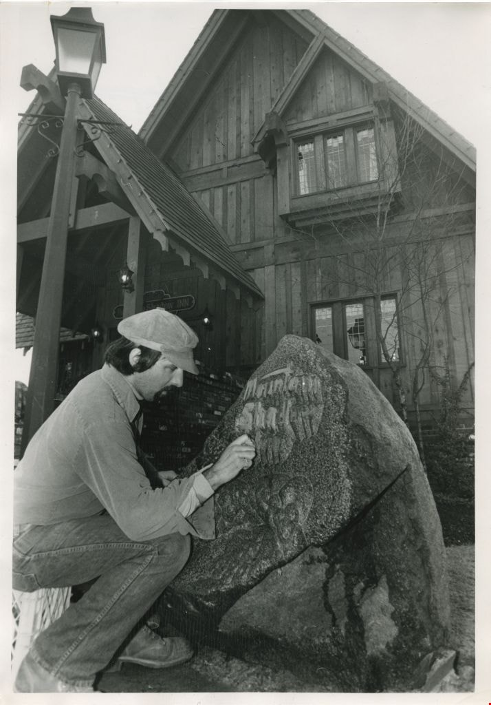
A man outside the Mountain Shadow Pub
https://search.heritageburnaby.ca/link/archivedescription58922
- Repository
- City of Burnaby Archives
- Date
- ca.1980
- Collection/Fonds
- Columbian Newspaper collection
- Description Level
- Item
- Physical Description
- 1 photograph : b&w ; 20.5 x 18 cm
- Scope and Content
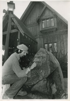
- Photograph of a man outside the Mountain Shadow Pub that was located at the base of Burnaby Mountain. He appears to be rewriting the name of the pub on a rock.
- Repository
- City of Burnaby Archives
- Date
- ca.1980
- Collection/Fonds
- Columbian Newspaper collection
- Physical Description
- 1 photograph : b&w ; 20.5 x 18 cm
- Description Level
- Item
- Record No.
- 480-1373
- Access Restriction
- No restrictions
- Reproduction Restriction
- Reproduce for fair dealing purposes only
- Accession Number
- 2009-01
- Scope and Content
- Photograph of a man outside the Mountain Shadow Pub that was located at the base of Burnaby Mountain. He appears to be rewriting the name of the pub on a rock.
- Subjects
- Buildings - Commercial
- Media Type
- Photograph
- Photographer
- Hodge, Craig
- Notes
- Title based on contents of photograph
- Photographer's stamp on verso
- Note on verso reads: "page A-3 / Burnaby Today / PMT 110%"
- Geographic Access
- Burnaby Mountain Conservation Area
- Historic Neighbourhood
- Lochdale (Historic Neighbourhood)
- Planning Study Area
- Burnaby Mountain Area
Images
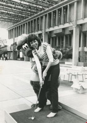
The A&W Bear with unidentified woman playing golf
https://search.heritageburnaby.ca/link/archivedescription58942
- Repository
- City of Burnaby Archives
- Date
- ca.1983
- Collection/Fonds
- Columbian Newspaper collection
- Description Level
- Item
- Physical Description
- 1 photograph : b&w ; 25.5 x 18 cm
- Scope and Content
- Photograph of the A&W Bear mascot helping an unidentified woman to line up her shot on a putting green. The photograph is taken in the Simon Fraser University Convocation Mall.
- Repository
- City of Burnaby Archives
- Date
- ca.1983
- Collection/Fonds
- Columbian Newspaper collection
- Physical Description
- 1 photograph : b&w ; 25.5 x 18 cm
- Description Level
- Item
- Record No.
- 480-1389
- Access Restriction
- No restrictions
- Reproduction Restriction
- Reproduce for fair dealing purposes only
- Accession Number
- 2009-01
- Scope and Content
- Photograph of the A&W Bear mascot helping an unidentified woman to line up her shot on a putting green. The photograph is taken in the Simon Fraser University Convocation Mall.
- Names
- Simon Fraser University
- Media Type
- Photograph
- Photographer
- King, Basil
- Notes
- Title based on contents of photograph
- Photographer's stamp on verso
- Note on verso reads: "Burnaby Today / A-1 / 136% / keep that"
- Geographic Access
- Burnaby Mountain Conservation Area
- Planning Study Area
- Burnaby Mountain Area
Images
![Bagpiper Rob MacNeil, [1999] thumbnail](/media/hpo/_Data/_Archives_Images/_Unrestricted/535/535-3364-1.jpg?width=280)
Bagpiper Rob MacNeil
https://search.heritageburnaby.ca/link/archivedescription98354
- Repository
- City of Burnaby Archives
- Date
- [1999]
- Collection/Fonds
- Burnaby NewsLeader photograph collection
- Description Level
- File
- Physical Description
- 2 photographs (tiff) : col.
- Scope and Content
- File contains photographs of Rob MacNeil, the manager of the Simon Fraser University Pipe Band. Photographs depict MacNeil in silhouette, playing bagpipes on top of Burnaby Mountain with the cityscape visible in the distance, and posing for a portrait.
- Repository
- City of Burnaby Archives
- Date
- [1999]
- Collection/Fonds
- Burnaby NewsLeader photograph collection
- Physical Description
- 2 photographs (tiff) : col.
- Description Level
- File
- Record No.
- 535-3364
- Access Restriction
- No restrictions
- Reproduction Restriction
- No restrictions
- Accession Number
- 2018-12
- Scope and Content
- File contains photographs of Rob MacNeil, the manager of the Simon Fraser University Pipe Band. Photographs depict MacNeil in silhouette, playing bagpipes on top of Burnaby Mountain with the cityscape visible in the distance, and posing for a portrait.
- Media Type
- Photograph
- Photographer
- Bartel, Mario
- Notes
- Title based on caption
- Collected by editorial for use in an October 1999 issue of the Burnaby NewsLeader
- Caption from metadata for 535-3364-1: "Rob MacNeil, the manager of the SFU Pipe Band, plays a lonely lament for the loss of the band's practice field atop Burnaby Mountain, because of a complaint to the Parks Board."
- Geographic Access
- Burnaby Mountain Conservation Area
- Planning Study Area
- Burnaby Mountain Area
Images
![Bagpiper Rob MacNeil, [1999] thumbnail](/media/hpo/_Data/_Archives_Images/_Unrestricted/535/535-3364-1.jpg)
![Banana slug on Burnaby Mountain, [1995] thumbnail](/media/Hpo/_Data/_Archives_Images/_Unrestricted/629/629-082.jpg?width=280)
Banana slug on Burnaby Mountain
https://search.heritageburnaby.ca/link/archivedescription97881
- Repository
- City of Burnaby Archives
- Date
- [1995]
- Collection/Fonds
- Burnaby Mountain Preservation Society fonds
- Description Level
- Item
- Physical Description
- 1 photograph : col. slide ; 35 mm
- Scope and Content
- Photograph of a banana slug.
- Repository
- City of Burnaby Archives
- Date
- [1995]
- Collection/Fonds
- Burnaby Mountain Preservation Society fonds
- Physical Description
- 1 photograph : col. slide ; 35 mm
- Description Level
- Item
- Record No.
- 629-082
- Access Restriction
- No restrictions
- Reproduction Restriction
- Reproduce for fair dealing purposes only
- Accession Number
- 2006-13
- Scope and Content
- Photograph of a banana slug.
- Subjects
- Animals
- Media Type
- Photograph
- Geographic Access
- Burnaby Mountain Conservation Area
- Planning Study Area
- Burnaby Mountain Area
Images
![Banana slug on Burnaby Mountain, [1995] thumbnail](/media/Hpo/_Data/_Archives_Images/_Unrestricted/629/629-082.jpg)
![Band-tailed pigeon on Burnaby Mountain, [1995] thumbnail](/media/Hpo/_Data/_Archives_Images/_Unrestricted/629/629-073.jpg?width=280)
Band-tailed pigeon on Burnaby Mountain
https://search.heritageburnaby.ca/link/archivedescription97872
- Repository
- City of Burnaby Archives
- Date
- [1995]
- Collection/Fonds
- Burnaby Mountain Preservation Society fonds
- Description Level
- Item
- Physical Description
- 1 photograph : col. slide ; 35 mm
- Scope and Content
- Photograph of a band-tailed pigeon.
- Repository
- City of Burnaby Archives
- Date
- [1995]
- Collection/Fonds
- Burnaby Mountain Preservation Society fonds
- Physical Description
- 1 photograph : col. slide ; 35 mm
- Description Level
- Item
- Record No.
- 629-073
- Access Restriction
- No restrictions
- Reproduction Restriction
- Reproduce for fair dealing purposes only
- Accession Number
- 2006-13
- Scope and Content
- Photograph of a band-tailed pigeon.
- Subjects
- Animals - Birds
- Media Type
- Photograph
- Geographic Access
- Burnaby Mountain Conservation Area
- Planning Study Area
- Burnaby Mountain Area
Images
![Band-tailed pigeon on Burnaby Mountain, [1995] thumbnail](/media/Hpo/_Data/_Archives_Images/_Unrestricted/629/629-073.jpg)

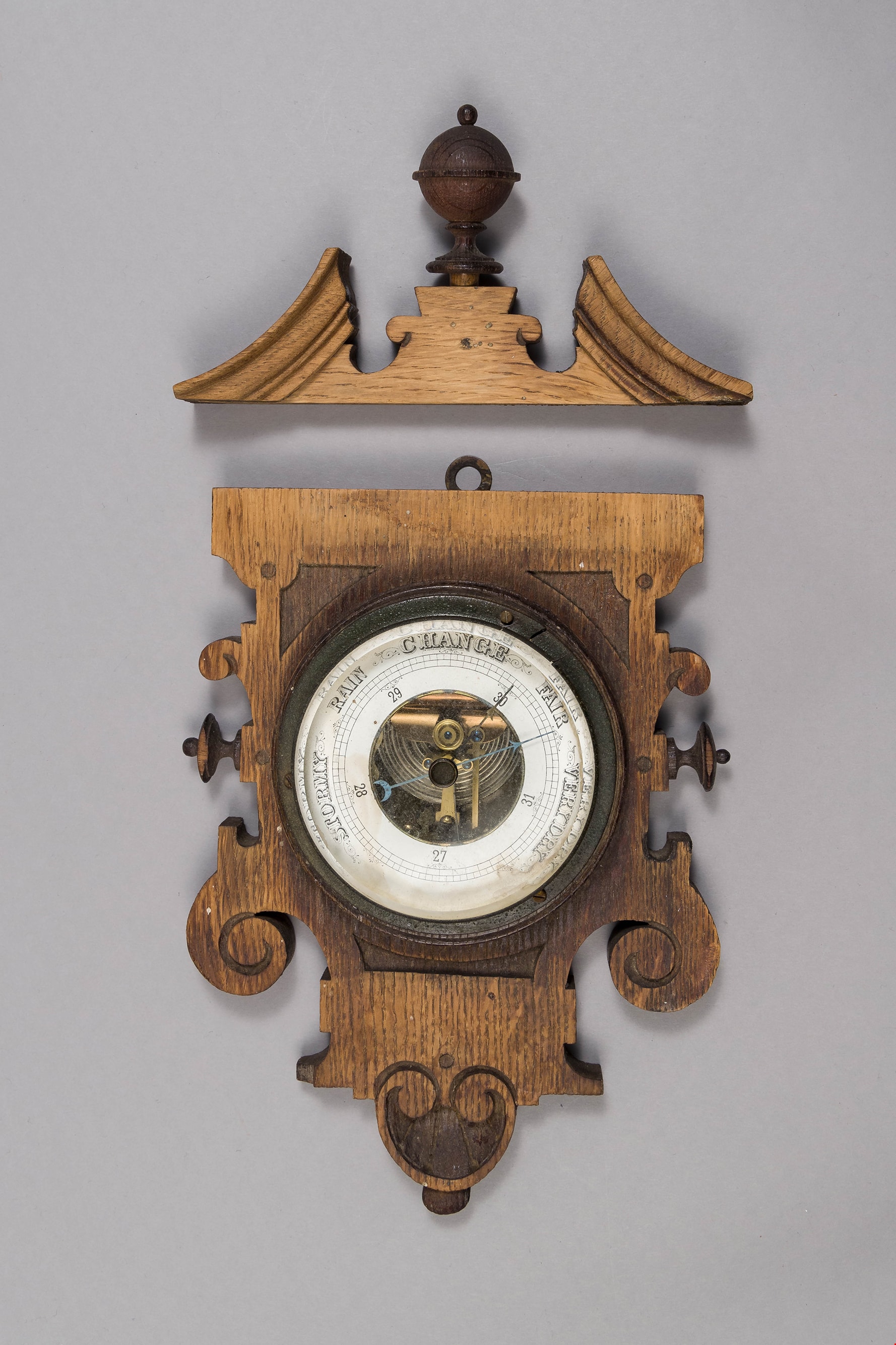
barometer
https://search.heritageburnaby.ca/link/museumartifact90178
- Repository
- Burnaby Village Museum
- Accession Code
- BV019.8.16
- Description
- barometer; aneroid barometer secured to a carved wood plaque; barometer has a calibrated dial to indicate air pressure; text on dial reads: "VERY DRY", "FAIR", "CHANGE", "RAIN", and "STORMY"; flat metal loop at top of wood plaque for hanging. Dark stained carved wood decorative scroll with finial; has detached from base plaque.
- Object History
- Object used in the Love Farmhouse, currently on site at Burnaby Village Museum.
- Geographic Access
- Cumberland Street
- Street Address
- 7651 Cumberland Street
- Historic Neighbourhood
- East Burnaby (Historic Neighbourhood)
- Planning Study Area
- Cariboo-Armstrong Area
Images
![Bea Carpenter, [1951 or 1952] (date of original), copied 1991 thumbnail](/media/hpo/_Data/_Archives_Images/_Unrestricted/370/370-122.jpg?width=280)
Bea Carpenter
https://search.heritageburnaby.ca/link/archivedescription37534
- Repository
- City of Burnaby Archives
- Date
- [1951 or 1952] (date of original), copied 1991
- Collection/Fonds
- Burnaby Historical Society fonds
- Description Level
- Item
- Physical Description
- 1 photograph : b&w ; 2.8 x 3.8 cm print on contact sheet 20.2 x 25.3 cm
- Scope and Content
- Photograph of Bea Carpenter standing beside a car (a 1950 Studebaker) in front of the George Derby Health Centre. She wearing her nurse's uniform.
- Repository
- City of Burnaby Archives
- Date
- [1951 or 1952] (date of original), copied 1991
- Collection/Fonds
- Burnaby Historical Society fonds
- Subseries
- Burnaby Image Bank subseries
- Physical Description
- 1 photograph : b&w ; 2.8 x 3.8 cm print on contact sheet 20.2 x 25.3 cm
- Description Level
- Item
- Record No.
- 370-122
- Access Restriction
- No restrictions
- Reproduction Restriction
- No restrictions
- Accession Number
- BHS1999-03
- Scope and Content
- Photograph of Bea Carpenter standing beside a car (a 1950 Studebaker) in front of the George Derby Health Centre. She wearing her nurse's uniform.
- Media Type
- Photograph
- Notes
- Title based on contents of photograph
- 1 b&w copy negative accompanying
- Geographic Access
- Cumberland Street
- Street Address
- 7550 Cumberland Street
- Historic Neighbourhood
- East Burnaby (Historic Neighbourhood)
- Planning Study Area
- Cariboo-Armstrong Area
Images
![Bea Carpenter, [1951 or 1952] (date of original), copied 1991 thumbnail](/media/hpo/_Data/_Archives_Images/_Unrestricted/370/370-122.jpg)

Bea Carpenter
https://search.heritageburnaby.ca/link/archivedescription37535
- Repository
- City of Burnaby Archives
- Date
- April 10, 1947 (date of original), copied 1991
- Collection/Fonds
- Burnaby Historical Society fonds
- Description Level
- Item
- Physical Description
- 1 photograph : b&w ; 3.7 x 3.1 cm print on contact sheet 20.2 x 25.3 cm
- Scope and Content
- Photograph of Bea Carpenter in the driveway of the George Derby Health Centre on opening day. She is in her nurses uniform and carrying flowers.
- Repository
- City of Burnaby Archives
- Date
- April 10, 1947 (date of original), copied 1991
- Collection/Fonds
- Burnaby Historical Society fonds
- Subseries
- Burnaby Image Bank subseries
- Physical Description
- 1 photograph : b&w ; 3.7 x 3.1 cm print on contact sheet 20.2 x 25.3 cm
- Description Level
- Item
- Record No.
- 370-123
- Access Restriction
- No restrictions
- Reproduction Restriction
- No known restrictions
- Accession Number
- BHS1999-03
- Scope and Content
- Photograph of Bea Carpenter in the driveway of the George Derby Health Centre on opening day. She is in her nurses uniform and carrying flowers.
- Media Type
- Photograph
- Notes
- Title based on contents of photograph
- 1 b&w copy negative accompanying
- Geographic Access
- Cumberland Street
- Street Address
- 7550 Cumberland Street
- Historic Neighbourhood
- East Burnaby (Historic Neighbourhood)
- Planning Study Area
- Cariboo-Armstrong Area
Images


Bea Carpenter
https://search.heritageburnaby.ca/link/archivedescription37536
- Repository
- City of Burnaby Archives
- Date
- 1947 (date of original), copied 1991
- Collection/Fonds
- Burnaby Historical Society fonds
- Description Level
- Item
- Physical Description
- 1 photograph : b&w ; 3.0 x 4.5 cm print on contact sheet 20.2 x 25.3 cm
- Scope and Content
- Photograph of Bea Carpenter in her nurses uniform with the George Derby Health Centre in the background.
- Repository
- City of Burnaby Archives
- Date
- 1947 (date of original), copied 1991
- Collection/Fonds
- Burnaby Historical Society fonds
- Subseries
- Burnaby Image Bank subseries
- Physical Description
- 1 photograph : b&w ; 3.0 x 4.5 cm print on contact sheet 20.2 x 25.3 cm
- Description Level
- Item
- Record No.
- 370-124
- Access Restriction
- No restrictions
- Reproduction Restriction
- No known restrictions
- Accession Number
- BHS1999-03
- Scope and Content
- Photograph of Bea Carpenter in her nurses uniform with the George Derby Health Centre in the background.
- Media Type
- Photograph
- Notes
- Title based on contents of photograph
- 1 b&w copy negative accompanying
- Geographic Access
- Cumberland Street
- Street Address
- 7550 Cumberland Street
- Historic Neighbourhood
- East Burnaby (Historic Neighbourhood)
- Planning Study Area
- Cariboo-Armstrong Area
Images

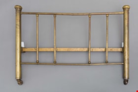
bed headboard
https://search.heritageburnaby.ca/link/museumartifact39541
- Repository
- Burnaby Village Museum
- Accession Code
- BV998.74.1
- Description
- Headboard, brass; has corner posts; on ball-bearing casters; top and bottom rails with five supporting rails; posts are 2" thick; top and bottom rails are 3/4" thick and verticals are 5/8" thick
- Object History
- The bed belonged to Leonard Love, son of Jesse and Martha Love.
- Category
- 02. Furnishings
- Classification
- Sleeping and Reclining Furniture
- Object Term
- Headboard
- Subjects
- Furniture
- Geographic Access
- Cumberland Street
- Historic Neighbourhood
- East Burnaby (Historic Neighbourhood)
- Planning Study Area
- Second Street Area
Images
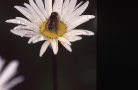
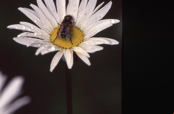
Bee on a daisy on Burnaby Mountain
https://search.heritageburnaby.ca/link/archivedescription97903
- Repository
- City of Burnaby Archives
- Date
- 1991
- Collection/Fonds
- Burnaby Mountain Preservation Society fonds
- Description Level
- Item
- Physical Description
- 1 photograph : col. slide ; 35 mm
- Scope and Content
- Photograph of a bee on a daisy.
- Repository
- City of Burnaby Archives
- Date
- 1991
- Collection/Fonds
- Burnaby Mountain Preservation Society fonds
- Physical Description
- 1 photograph : col. slide ; 35 mm
- Description Level
- Item
- Record No.
- 629-104
- Access Restriction
- No restrictions
- Reproduction Restriction
- Reproduce for fair dealing purposes only
- Accession Number
- 2006-13
- Scope and Content
- Photograph of a bee on a daisy.
- Subjects
- Plants - Flowers
- Animals
- Media Type
- Photograph
- Notes
- Handwritten note on slide reads: "Bee"; stamp on slide reads: "June 10, 1991."
- Geographic Access
- Burnaby Mountain Conservation Area
- Planning Study Area
- Burnaby Mountain Area
Images
![Big Brothers Soap Box Derby, [1999] thumbnail](/media/hpo/_Data/_Archives_Images/_Unrestricted/535/535-3345.jpg?width=280)
Big Brothers Soap Box Derby
https://search.heritageburnaby.ca/link/archivedescription98321
- Repository
- City of Burnaby Archives
- Date
- [1999]
- Collection/Fonds
- Burnaby NewsLeader photograph collection
- Description Level
- Item
- Physical Description
- 1 photograph (tiff) : col.
- Scope and Content
- Photograph of ten-year-old Zach Admussen buckled into a soap box race car and adjusting his helmet, before the 11th annual Big Brothers Soap Box Derby on Burnaby Mountain.
- Repository
- City of Burnaby Archives
- Date
- [1999]
- Collection/Fonds
- Burnaby NewsLeader photograph collection
- Physical Description
- 1 photograph (tiff) : col.
- Description Level
- Item
- Record No.
- 535-3345
- Access Restriction
- No restrictions
- Reproduction Restriction
- No restrictions
- Accession Number
- 2018-12
- Scope and Content
- Photograph of ten-year-old Zach Admussen buckled into a soap box race car and adjusting his helmet, before the 11th annual Big Brothers Soap Box Derby on Burnaby Mountain.
- Media Type
- Photograph
- Photographer
- Bartel, Mario
- Notes
- Title based on caption
- Collected by editorial for use in a September 1999 issue of the Burnaby NewsLeader
- Caption from metadata: "Zach Admussen, 10, adjusts his helmet as he prepares to pilot his car down the ring road on Burnaby Mountain, at the 11th annual Big Brothers Soap Box Derby."
- Geographic Access
- Burnaby Mountain Conservation Area
- Planning Study Area
- Burnaby Mountain Area
Images
![Big Brothers Soap Box Derby, [1999] thumbnail](/media/hpo/_Data/_Archives_Images/_Unrestricted/535/535-3345.jpg)
![Bird's nest fungus on Burnaby Mountain, [1995] thumbnail](/media/Hpo/_Data/_Archives_Images/_Unrestricted/629/629-095.jpg?width=280)
Bird's nest fungus on Burnaby Mountain
https://search.heritageburnaby.ca/link/archivedescription97894
- Repository
- City of Burnaby Archives
- Date
- [1995]
- Collection/Fonds
- Burnaby Mountain Preservation Society fonds
- Description Level
- Item
- Physical Description
- 1 photograph : col. slide ; 35 mm
- Scope and Content
- Photograph of bird's nest fungus.
- Repository
- City of Burnaby Archives
- Date
- [1995]
- Collection/Fonds
- Burnaby Mountain Preservation Society fonds
- Physical Description
- 1 photograph : col. slide ; 35 mm
- Description Level
- Item
- Record No.
- 629-095
- Access Restriction
- No restrictions
- Reproduction Restriction
- Reproduce for fair dealing purposes only
- Accession Number
- 2006-13
- Scope and Content
- Photograph of bird's nest fungus.
- Media Type
- Photograph
- Geographic Access
- Burnaby Mountain Conservation Area
- Planning Study Area
- Burnaby Mountain Area
Images
![Bird's nest fungus on Burnaby Mountain, [1995] thumbnail](/media/Hpo/_Data/_Archives_Images/_Unrestricted/629/629-095.jpg)

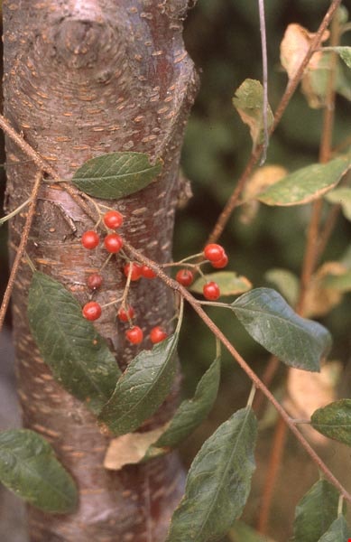
Bitter cherry tree on Burnaby Mountain
https://search.heritageburnaby.ca/link/archivedescription97821
- Repository
- City of Burnaby Archives
- Date
- 1997
- Collection/Fonds
- Burnaby Mountain Preservation Society fonds
- Description Level
- Item
- Physical Description
- 1 photograph : col. slide ; 35 mm
- Scope and Content
- Photograph of a bitter cherry tree.
- Repository
- City of Burnaby Archives
- Date
- 1997
- Collection/Fonds
- Burnaby Mountain Preservation Society fonds
- Physical Description
- 1 photograph : col. slide ; 35 mm
- Description Level
- Item
- Record No.
- 629-022
- Access Restriction
- No restrictions
- Reproduction Restriction
- Reproduce for fair dealing purposes only
- Accession Number
- 2006-13
- Scope and Content
- Photograph of a bitter cherry tree.
- Subjects
- Plants - Trees
- Media Type
- Photograph
- Notes
- Stamp on slide reads: "Aug 22, 1997."
- Geographic Access
- Burnaby Mountain Conservation Area
- Planning Study Area
- Burnaby Mountain Area
Images
![Black bear on Burnaby Mountain, [1995] thumbnail](/media/Hpo/_Data/_Archives_Images/_Unrestricted/629/629-080.jpg?width=280)
Black bear on Burnaby Mountain
https://search.heritageburnaby.ca/link/archivedescription97879
- Repository
- City of Burnaby Archives
- Date
- [1995]
- Collection/Fonds
- Burnaby Mountain Preservation Society fonds
- Description Level
- Item
- Physical Description
- 1 photograph : col. slide ; 35 mm
- Scope and Content
- Photograph of a black bear.
- Repository
- City of Burnaby Archives
- Date
- [1995]
- Collection/Fonds
- Burnaby Mountain Preservation Society fonds
- Physical Description
- 1 photograph : col. slide ; 35 mm
- Description Level
- Item
- Record No.
- 629-080
- Access Restriction
- No restrictions
- Reproduction Restriction
- Reproduce for fair dealing purposes only
- Accession Number
- 2006-13
- Scope and Content
- Photograph of a black bear.
- Subjects
- Animals - Bears
- Media Type
- Photograph
- Photographer
- Wheately, Michael
- Notes
- Handwritten notes on slide read: "Black Bear Burnaby Mt." and "Copyright Michael Wheately"; stamp on slide reads: "94-09-27."
- Geographic Access
- Burnaby Mountain Conservation Area
- Planning Study Area
- Burnaby Mountain Area
Images
![Black bear on Burnaby Mountain, [1995] thumbnail](/media/Hpo/_Data/_Archives_Images/_Unrestricted/629/629-080.jpg)
![Blackberries on Burnaby Mountain, [1995] thumbnail](/media/Hpo/_Data/_Archives_Images/_Unrestricted/629/629-046.jpg?width=280)
Blackberries on Burnaby Mountain
https://search.heritageburnaby.ca/link/archivedescription97845
- Repository
- City of Burnaby Archives
- Date
- [1995]
- Collection/Fonds
- Burnaby Mountain Preservation Society fonds
- Description Level
- Item
- Physical Description
- 1 photograph : col. slide ; 35 mm
- Scope and Content
- Photograph of blackberries.
- Repository
- City of Burnaby Archives
- Date
- [1995]
- Collection/Fonds
- Burnaby Mountain Preservation Society fonds
- Physical Description
- 1 photograph : col. slide ; 35 mm
- Description Level
- Item
- Record No.
- 629-046
- Access Restriction
- No restrictions
- Reproduction Restriction
- Reproduce for fair dealing purposes only
- Accession Number
- 2006-13
- Scope and Content
- Photograph of blackberries.
- Subjects
- Plants
- Media Type
- Photograph
- Geographic Access
- Burnaby Mountain Conservation Area
- Planning Study Area
- Burnaby Mountain Area
Images
![Blackberries on Burnaby Mountain, [1995] thumbnail](/media/Hpo/_Data/_Archives_Images/_Unrestricted/629/629-046.jpg)
![Black-capped chickadee on Burnaby Mountain, [1995] thumbnail](/media/Hpo/_Data/_Archives_Images/_Unrestricted/629/629-064.jpg?width=280)
Black-capped chickadee on Burnaby Mountain
https://search.heritageburnaby.ca/link/archivedescription97863
- Repository
- City of Burnaby Archives
- Date
- [1995]
- Collection/Fonds
- Burnaby Mountain Preservation Society fonds
- Description Level
- Item
- Physical Description
- 1 photograph : col. slide ; 35 mm
- Scope and Content
- Photograph of a black-capped chickadee on a log.
- Repository
- City of Burnaby Archives
- Date
- [1995]
- Collection/Fonds
- Burnaby Mountain Preservation Society fonds
- Physical Description
- 1 photograph : col. slide ; 35 mm
- Description Level
- Item
- Record No.
- 629-064
- Access Restriction
- No restrictions
- Reproduction Restriction
- Reproduce for fair dealing purposes only
- Accession Number
- 2006-13
- Scope and Content
- Photograph of a black-capped chickadee on a log.
- Subjects
- Animals - Birds
- Media Type
- Photograph
- Geographic Access
- Burnaby Mountain Conservation Area
- Planning Study Area
- Burnaby Mountain Area
Images
![Black-capped chickadee on Burnaby Mountain, [1995] thumbnail](/media/Hpo/_Data/_Archives_Images/_Unrestricted/629/629-064.jpg)
![Blossoming trees in Burnaby Mountain Park, [2000] thumbnail](/media/hpo/_Data/_Archives_Images/_Unrestricted/535/535-2153.jpg?width=280)
Blossoming trees in Burnaby Mountain Park
https://search.heritageburnaby.ca/link/archivedescription96529
- Repository
- City of Burnaby Archives
- Date
- [2000]
- Collection/Fonds
- Burnaby NewsLeader photograph collection
- Description Level
- Item
- Physical Description
- 1 photograph (tiff) : col.
- Scope and Content
- Photograph of two unidentified students standing underneath blossoming trees in Burnaby Mountain Park.
- Repository
- City of Burnaby Archives
- Date
- [2000]
- Collection/Fonds
- Burnaby NewsLeader photograph collection
- Physical Description
- 1 photograph (tiff) : col.
- Description Level
- Item
- Record No.
- 535-2153
- Access Restriction
- No restrictions
- Reproduction Restriction
- No restrictions
- Accession Number
- 2018-12
- Scope and Content
- Photograph of two unidentified students standing underneath blossoming trees in Burnaby Mountain Park.
- Names
- Burnaby Mountain Park
- Media Type
- Photograph
- Photographer
- Bartel, Mario
- Notes
- Title based on caption
- Collected by editorial for use in an April 2000 issue of the Burnaby NewsLeader
- Caption from metadata: "Students on a field trip at Burnaby Mountain Park are canopied by blossoms. The delicate spring flowers are at their peak at the park's higher elevation."
- Geographic Access
- Burnaby Mountain Conservation Area
- Planning Study Area
- Burnaby Mountain Area
Images
![Blossoming trees in Burnaby Mountain Park, [2000] thumbnail](/media/hpo/_Data/_Archives_Images/_Unrestricted/535/535-2153.jpg)
![Blue heron on Burnaby Mountain, [1995] thumbnail](/media/Hpo/_Data/_Archives_Images/_Unrestricted/629/629-116.jpg?width=280)
Blue heron on Burnaby Mountain
https://search.heritageburnaby.ca/link/archivedescription97915
- Repository
- City of Burnaby Archives
- Date
- [1995]
- Collection/Fonds
- Burnaby Mountain Preservation Society fonds
- Description Level
- Item
- Physical Description
- 1 photograph : col. slide ; 35 mm
- Scope and Content
- Photograph of a blue heron standing in the water.
- Repository
- City of Burnaby Archives
- Date
- [1995]
- Collection/Fonds
- Burnaby Mountain Preservation Society fonds
- Physical Description
- 1 photograph : col. slide ; 35 mm
- Description Level
- Item
- Record No.
- 629-116
- Access Restriction
- No restrictions
- Reproduction Restriction
- Reproduce for fair dealing purposes only
- Accession Number
- 2006-13
- Scope and Content
- Photograph of a blue heron standing in the water.
- Subjects
- Animals - Birds
- Media Type
- Photograph
- Notes
- Handwritten note on slide reads: "B. Heron"; stamp on slide reads: "23 JUL."
- Geographic Access
- Burnaby Mountain Conservation Area
- Planning Study Area
- Burnaby Mountain Area
Images
![Blue heron on Burnaby Mountain, [1995] thumbnail](/media/Hpo/_Data/_Archives_Images/_Unrestricted/629/629-116.jpg)
![Bob Love, [191-] thumbnail](/media/hpo/_Data/_BVM_Images/2022/2022_0032_0134_001.jpg?width=280)
Bob Love
https://search.heritageburnaby.ca/link/museumdescription19712
- Repository
- Burnaby Village Museum
- Date
- [191-]
- Collection/Fonds
- Esther Love Stanley fonds
- Description Level
- Item
- Physical Description
- 1 photograph : b&w ; 10.5 x 8 cm
- Scope and Content
- Photograph of Thomas Robert "Bob" Love, standing in an orchard at the Love family home at 1390 Cumberland Road. Bob's right arm is bent with his hand on his waist. He is wearing a white collared shirt with tie, dark pants, belt and suspenders. Orchard trees in full leaf are in background. Bob Love…
- Repository
- Burnaby Village Museum
- Collection/Fonds
- Esther Love Stanley fonds
- Description Level
- Item
- Physical Description
- 1 photograph : b&w ; 10.5 x 8 cm
- Scope and Content
- Photograph of Thomas Robert "Bob" Love, standing in an orchard at the Love family home at 1390 Cumberland Road. Bob's right arm is bent with his hand on his waist. He is wearing a white collared shirt with tie, dark pants, belt and suspenders. Orchard trees in full leaf are in background. Bob Love served in World War 1 and died at the age of 31 years on November 23, 1918.
- Geographic Access
- Cumberland Street
- Street Address
- 7651 Cumberland Street
- Accession Code
- BV022.32.134
- Access Restriction
- No restrictions
- Reproduction Restriction
- No known restrictions
- Date
- [191-]
- Media Type
- Photograph
- Historic Neighbourhood
- East Burnaby (Historic Neighbourhood)
- Planning Study Area
- Cariboo-Armstrong Area
- Related Material
- See also BV022.32.514
- Scan Resolution
- 600
- Scan Date
- 2023-04-04
- Notes
- Title based on contents of photograph
- Photograph is part of Esther Love Stanley photograph album 1 (BV022.32.1)
- Note in white ink on album page reads: "BOB"
Images
![Bob Love, [191-] thumbnail](/media/hpo/_Data/_BVM_Images/2022/2022_0032_0134_001.jpg)
![Bob Love on porch, [191-] thumbnail](/media/hpo/_Data/_BVM_Images/2022/2022_0032_0162_001.jpg?width=280)
Bob Love on porch
https://search.heritageburnaby.ca/link/museumdescription19740
- Repository
- Burnaby Village Museum
- Date
- [191-]
- Collection/Fonds
- Esther Love Stanley fonds
- Description Level
- Item
- Physical Description
- 1 photograph : b&w ; 8 x 10.5 cm
- Scope and Content
- Photograph of Thomas Robert "Bob" Love standing on the front porch of the Love family home on Cumberland Road.
- Repository
- Burnaby Village Museum
- Collection/Fonds
- Esther Love Stanley fonds
- Description Level
- Item
- Physical Description
- 1 photograph : b&w ; 8 x 10.5 cm
- Scope and Content
- Photograph of Thomas Robert "Bob" Love standing on the front porch of the Love family home on Cumberland Road.
- Geographic Access
- Cumberland Street
- Street Address
- 7651 Cumberland Street
- Accession Code
- BV022.32.162
- Access Restriction
- No restrictions
- Reproduction Restriction
- No known restrictions
- Date
- [191-]
- Media Type
- Photograph
- Historic Neighbourhood
- East Burnaby (Historic Neighbourhood)
- Planning Study Area
- Cariboo-Armstrong Area
- Scan Resolution
- 600
- Scan Date
- 2023-04-04
- Notes
- Title based on contents of photograph
- Photograph is part of Esther Love Stanley photograph album 1 (BV022.32.1)
- Annotation in white on album page reads: "Bob"
Images
![Bob Love on porch, [191-] thumbnail](/media/hpo/_Data/_BVM_Images/2022/2022_0032_0162_001.jpg)
![Bob or Henry Love on porch, [191-] thumbnail](/media/hpo/_Data/_BVM_Images/2022/2022_0032_0154_001.jpg?width=280)
Bob or Henry Love on porch
https://search.heritageburnaby.ca/link/museumdescription19732
- Repository
- Burnaby Village Museum
- Date
- [191-]
- Collection/Fonds
- Esther Love Stanley fonds
- Description Level
- Item
- Physical Description
- 1 photograph : b&w ; 10.5 x 8 cm
- Scope and Content
- Photograph of Henry or Bob Love standing on the front porch of the Love family home on Cumberland Road.
- Repository
- Burnaby Village Museum
- Collection/Fonds
- Esther Love Stanley fonds
- Description Level
- Item
- Physical Description
- 1 photograph : b&w ; 10.5 x 8 cm
- Scope and Content
- Photograph of Henry or Bob Love standing on the front porch of the Love family home on Cumberland Road.
- Geographic Access
- Cumberland Street
- Street Address
- 7651 Cumberland Street
- Accession Code
- BV022.32.154
- Access Restriction
- No restrictions
- Reproduction Restriction
- No known restrictions
- Date
- [191-]
- Media Type
- Photograph
- Historic Neighbourhood
- East Burnaby (Historic Neighbourhood)
- Planning Study Area
- Cariboo-Armstrong Area
- Scan Resolution
- 600
- Scan Date
- 2023-04-04
- Notes
- Title based on contents of photograph
- Photograph is part of Esther Love Stanley photograph album 1 (BV022.32.1)
Images
![Bob or Henry Love on porch, [191-] thumbnail](/media/hpo/_Data/_BVM_Images/2022/2022_0032_0154_001.jpg)
![Bracken fern on Burnaby Mountain, [1995] thumbnail](/media/Hpo/_Data/_Archives_Images/_Unrestricted/629/629-025.jpg?width=280)
Bracken fern on Burnaby Mountain
https://search.heritageburnaby.ca/link/archivedescription97824
- Repository
- City of Burnaby Archives
- Date
- [1995]
- Collection/Fonds
- Burnaby Mountain Preservation Society fonds
- Description Level
- Item
- Physical Description
- 1 photograph : col. slide ; 35 mm
- Scope and Content
- Photograph of a bracken fern.
- Repository
- City of Burnaby Archives
- Date
- [1995]
- Collection/Fonds
- Burnaby Mountain Preservation Society fonds
- Physical Description
- 1 photograph : col. slide ; 35 mm
- Description Level
- Item
- Record No.
- 629-025
- Access Restriction
- No restrictions
- Reproduction Restriction
- Reproduce for fair dealing purposes only
- Accession Number
- 2006-13
- Scope and Content
- Photograph of a bracken fern.
- Subjects
- Plants
- Media Type
- Photograph
- Notes
- Stamp on slide reads: "21 JUL."
- Geographic Access
- Burnaby Mountain Conservation Area
- Planning Study Area
- Burnaby Mountain Area
Images
![Bracken fern on Burnaby Mountain, [1995] thumbnail](/media/Hpo/_Data/_Archives_Images/_Unrestricted/629/629-025.jpg)
![Bridge over South Creek on Burnaby Mountain, [1995] thumbnail](/media/Hpo/_Data/_Archives_Images/_Unrestricted/629/629-009.jpg?width=280)
Bridge over South Creek on Burnaby Mountain
https://search.heritageburnaby.ca/link/archivedescription97808
- Repository
- City of Burnaby Archives
- Date
- [1995]
- Collection/Fonds
- Burnaby Mountain Preservation Society fonds
- Description Level
- Item
- Physical Description
- 1 photograph : col. slide ; 35 mm
- Scope and Content
- Photograph of a creek bridge.
- Repository
- City of Burnaby Archives
- Date
- [1995]
- Collection/Fonds
- Burnaby Mountain Preservation Society fonds
- Physical Description
- 1 photograph : col. slide ; 35 mm
- Description Level
- Item
- Record No.
- 629-009
- Access Restriction
- No restrictions
- Reproduction Restriction
- Reproduce for fair dealing purposes only
- Accession Number
- 2006-13
- Scope and Content
- Photograph of a creek bridge.
- Media Type
- Photograph
- Notes
- Handwritten note on slide reads: "Bridge Over S. Creek."
- Geographic Access
- Burnaby Mountain Conservation Area
- Planning Study Area
- Burnaby Mountain Area
Images
![Bridge over South Creek on Burnaby Mountain, [1995] thumbnail](/media/Hpo/_Data/_Archives_Images/_Unrestricted/629/629-009.jpg)

B room, northeast view and window
https://search.heritageburnaby.ca/link/museumdescription10769
- Repository
- Burnaby Village Museum
- Date
- May 12, 1988
- Collection/Fonds
- Burnaby Village Museum fonds
- Description Level
- Item
- Physical Description
- 1 photograph : b&w negative ; 35 mm
- Scope and Content
- Photograph of northeast view and window in room "B", upstairs in the Love farmhouse while it was located at 7651 Cumberland Street (the corner of 14th Avenue and Cumberland Street).
- Repository
- Burnaby Village Museum
- Collection/Fonds
- Burnaby Village Museum fonds
- Series
- Jesse Love farmhouse series
- Description Level
- Item
- Physical Description
- 1 photograph : b&w negative ; 35 mm
- Material Details
- Photograph is part of Film roll "D" - 37 b&w photographs that are a part of a collection described as BV018.41.82
- Scope and Content
- Photograph of northeast view and window in room "B", upstairs in the Love farmhouse while it was located at 7651 Cumberland Street (the corner of 14th Avenue and Cumberland Street).
- Subjects
- Buildings - Heritage
- Geographic Access
- Cumberland Street
- Street Address
- 7651 Cumberland Street
- Accession Code
- BV018.41.292
- Access Restriction
- No restrictions
- Reproduction Restriction
- No known restrictions
- Date
- May 12, 1988
- Media Type
- Photograph
- Historic Neighbourhood
- East Burnaby (Historic Neighbourhood)
- Planning Study Area
- Cariboo-Armstrong Area
- Related Material
- See BV018.41.82 for File Level Description
- Scan Resolution
- 2400
- Scan Date
- 13-May-19
- Scale
- 100
- Photographer
- Wolf, Jim
- Notes
- Title based on contents of photograph
- Photograph is a part of file level description "Photographic documentation of changes and move" BV018.41.82
Images


B room, northwest corner and bathtub
https://search.heritageburnaby.ca/link/museumdescription10770
- Repository
- Burnaby Village Museum
- Date
- May 12, 1988
- Collection/Fonds
- Burnaby Village Museum fonds
- Description Level
- Item
- Physical Description
- 1 photograph : b&w negative ; 35 mm
- Scope and Content
- Photograph of the northwest corner and bathtub in room "B", upstairs in the Love farmhouse while it was located at 7651 Cumberland Street (the corner of 14th Avenue and Cumberland Street).
- Repository
- Burnaby Village Museum
- Collection/Fonds
- Burnaby Village Museum fonds
- Series
- Jesse Love farmhouse series
- Description Level
- Item
- Physical Description
- 1 photograph : b&w negative ; 35 mm
- Material Details
- Photograph is part of Film roll "D" - 37 b&w photographs that are a part of a collection described as BV018.41.82
- Scope and Content
- Photograph of the northwest corner and bathtub in room "B", upstairs in the Love farmhouse while it was located at 7651 Cumberland Street (the corner of 14th Avenue and Cumberland Street).
- Subjects
- Buildings - Heritage
- Geographic Access
- Cumberland Street
- Street Address
- 7651 Cumberland Street
- Accession Code
- BV018.41.293
- Access Restriction
- No restrictions
- Reproduction Restriction
- No known restrictions
- Date
- May 12, 1988
- Media Type
- Photograph
- Historic Neighbourhood
- East Burnaby (Historic Neighbourhood)
- Planning Study Area
- Cariboo-Armstrong Area
- Related Material
- See BV018.41.82 for File Level Description
- Scan Resolution
- 2400
- Scan Date
- 13-May-19
- Scale
- 100
- Photographer
- Wolf, Jim
- Notes
- Title based on contents of photograph
- Photograph is a part of file level description "Photographic documentation of changes and move" BV018.41.82
Images
