Narrow Results By

Inman Avenue School site
https://search.heritageburnaby.ca/link/museumdescription11128
- Repository
- Burnaby Village Museum
- Date
- May 3, 1915
- Collection/Fonds
- Ronald G. Scobbie collection
- Description Level
- Item
- Physical Description
- 1 survey plan : blueprint on paper ; 56 x 54 cm
- Scope and Content
- Survey plan of "Inman Avenue School Site" "Burnaby Municipality" "Being Lots 3 -12 inc. Blk. C. of Subd. of Blks.5" "13-19 inc. & 21-28 inc. of Subd. of Westerly 80 Acres of, and portion of D.L. 34, Group One. New Westminster District".
- Repository
- Burnaby Village Museum
- Collection/Fonds
- Ronald G. Scobbie collection
- Description Level
- Item
- Physical Description
- 1 survey plan : blueprint on paper ; 56 x 54 cm
- Material Details
- Scale: 40 feet = 1 inch
- Scope and Content
- Survey plan of "Inman Avenue School Site" "Burnaby Municipality" "Being Lots 3 -12 inc. Blk. C. of Subd. of Blks.5" "13-19 inc. & 21-28 inc. of Subd. of Westerly 80 Acres of, and portion of D.L. 34, Group One. New Westminster District".
- Creator
- McGugan, Donald Johnston
- Subjects
- Buildings - Schools
- Names
- Inman Avenue School
- Responsibility
- Burnett & McGugan, Engineers and Surveyors
- Geographic Access
- Brandon Street
- Street Address
- 3963 Brandon Street
- Accession Code
- BV003.83.7
- Access Restriction
- No restrictions
- Reproduction Restriction
- No known restrictions
- Date
- May 3, 1915
- Media Type
- Cartographic Material
- Historic Neighbourhood
- Central Park (Historic Neighbourhood)
- Planning Study Area
- Garden Village Area
- Scan Resolution
- 440
- Scan Date
- 22-Dec-2020
- Scale
- 100
- Notes
- Title based on contents of plan
- Oath in bottom left corner reads: "I, D.J. McGugan...did...superintend the survey...", "...completed on the 3rd day of May 1915"; signed "D.J. McGugan", notariz- ed by "Walter Edmonds" "sworn...22nd Day of May 1915"; "Burnett and McGugan. B.C. Land Surveyors. Etc. New Westminster. B.C.";
- handwritten note reads: "Note: Before using this Mon. see plan / of resubdivision of Lots 5 & 6 / of Block 'B' D.L. 34 / June 1945"
- handwritten twice on back, "1776"
Zoomable Images

postcard
https://search.heritageburnaby.ca/link/museumartifact90986
- Repository
- Burnaby Village Museum
- Accession Code
- BV021.12.1
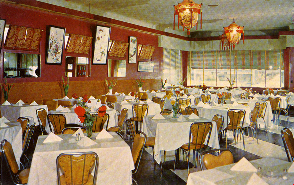
- Description
- Postcard: horizontal glossy colour postcard of Golden Dragon Resturant. Shows image of interior dining room with red and gold walls, laterns, tables with white table cloths. yellow chairs and a stripped black and white floor. On reservse in blue print: , "GOLDEN DRAGON" "3991 KINGSWAY" "BURNABY, B.C." "Phone: DExter 5100" "If you are not familiar with Chinese Foods let our Experts make suggestions and explain the traditions of eating that is famous throughout the world."; at bottom, "DINE and DANCE Every FRIDAY & SATURDAY"; line down centre; at right,"POST CARD" "ADDRESS"; at upper right, "STAMP"; unused; ca.1950s
- Object History
- Postcard from the Golden Dragon Resturant which served Chinese-Canadian food. Their grand opening was September 2, 1950. The community staple was known for its neon dragon sign that advertised “Chop Suey”. One side of the kitchen served Chinese foods, while another served Canadian dishes. Chinese cuisine such as rice would be served with chopsticks, while steaks, a more western dish, would be served with knife and fork. Advertisements from the resturant and meeting notices were found in local newspapers from 1950 to 1957. The establishment was not listed in the 1966 Great Vancouver Cross-Cross Directory.
- Classification
- Written Communication T&E - - Writing Media
- Object Term
- Postcard
- Marks/Labels
- Made in Canada by Grant-Mann Lithographers LTD. "Color Card" Division, Vancouver, British Columbia.
- Measurements
- 14cm wide x 9cm high
- Subjects
- Souvenirs
- Persons - Chinese Canadians
- Food Service Tools and Equipment
- Documentary Artifacts - Postcards
- Buildings - Commercial - Restaurants
- Historic Neighbourhood
- Central Park (Historic Neighbourhood)
- Planning Study Area
- Garden Village Area
Images