Narrow Results By
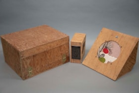
audio amplification set
https://search.heritageburnaby.ca/link/museumartifact91427
- Repository
- Burnaby Village Museum
- Accession Code
- BV021.22.1
- Description
- A large box containing a audio-amp, a wooden triangular prism with a decorative round speaker, and six smaller rectangular boxes. All are made of a light wood, and have different functions.
- Object History
- This audio-amplifier set was used by Mr. Edward A. Fountain, who was appointed as Civil Defense Coordinator on May 5th, 1952. He also built the wooden boxes which contain each part of the set. The Burnaby Civil Defense Department was established in order to disseminate information guiding the public on how to react in response to the impending threat of nuclear war and Russian bombers. In the early 1950’s, this education centered primarily on evacuation, as members of the public were expected to prepare and essentially fend for themselves in the event of a nuclear attack. These pieces of audio technology are believed to have been used at Civil Defense rallies in Burnaby, which Edward Fountain would have been involved in as the department director. According to Burnaby City Council meeting records, music and defense operation demonstrations were commonplace at such rallies, and are examples of what this set was used for.
- Classification
- Telecommunication T&E - - Telecommunication Devices
- Object Term
- Radio
- Colour
- Brown
- Country Made
- Canada
- Province Made
- British Columbia
- Site/City Made
- Burnaby
- Subjects
- Communication Artifacts
- Names
- Fountain, Edward
- Geographic Access
- Burnaby Lake
- Planning Study Area
- Windsor Area
Images
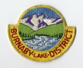
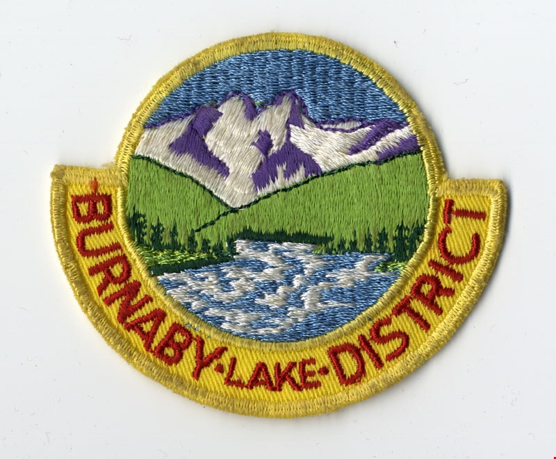
badge
https://search.heritageburnaby.ca/link/museumartifact48258
- Repository
- Burnaby Village Museum
- Accession Code
- BV005.13.41
- Description
- Badge, cloth, circular; yellow, green, white, red, blue; scene of mountains, river and field with a yellow bar across bottom with red lettering.
- Object History
- Scouts Canada
- Marks/Labels
- "BURNABY LAKE (smaller) DISTRICT", stitching, red
- Subjects
- Organizations
- Organizations - Boys' Societies and Clubs
- Personal Symbols
- Personal Symbols - Badges
- Geographic Access
- Burnaby Lake
Images

Bird's Eye View of the Burnaby Lake Area
https://search.heritageburnaby.ca/link/museumdescription15144
- Repository
- Burnaby Village Museum
- Date
- 1977
- Collection/Fonds
- Century Park Museum Association fonds
- Description Level
- Item
- Physical Description
- 1 map : b&w print on paper ; 43 x 63.5 cm
- Scope and Content
- Item consists of a map titled "Birds Eye View of the Burnaby Lake Area Circa 1910". The overview of the Burnaby Lake area was compiled and drawn at Heritage Village by curator John Adams and artist, Carol Swan. The map identifies the Burnaby Lake inter-urban tram line; roads including: Sperling Ave…
- Repository
- Burnaby Village Museum
- Collection/Fonds
- Century Park Museum Association fonds
- Description Level
- Item
- Physical Description
- 1 map : b&w print on paper ; 43 x 63.5 cm
- Material Details
- Scale indeterminable
- Scope and Content
- Item consists of a map titled "Birds Eye View of the Burnaby Lake Area Circa 1910". The overview of the Burnaby Lake area was compiled and drawn at Heritage Village by curator John Adams and artist, Carol Swan. The map identifies the Burnaby Lake inter-urban tram line; roads including: Sperling Avenue (Pole Line Road); Gilpin Avenue; Douglas Road; trail to Vancouver Westminster Road (Kingsway); Buckingham Avenue; Haszard Street; various farms and residences including: Charles Sprott "Norland"; H.T. Ceperley "Fairacres"; Claude Hill's "Brookfield farm" and "Broadview"; F.J. Hart's "Avalon"; Miss Woodward's former and new home, school and post office; Councillor Edgar's hunting cabin; Edgar Sprott's "Mayfield farm" and "Mayfield Lodge"; F.J. Peers "Greyfriars"; Arthur de Windt Haszard; Bernard Hill's boathouse as well as other landmarks including: Doran's Mill; tram stations; Burnaby Lake Store; logging camps; wood cutter's shacks; ice houses; cranberry bog; Still Creek; Deer Lake; Burnaby Lake; Deer Lake Creek; Provincial Government Reserve Proposed Hospital (later Oakalla Prison).
- Creator
- Adams, John
- Swan, Carol
- Names
- Hill, Arthur Claude
- Sprott, Charles Frederick
- Sprott, Louis "Edgar"
- Hart, Frederick John, 1884-1945
- Ceperley, H.T.
- Woodward, Maude
- Woodward, Harriet
- Peers, Francis J.
- Haszard, Arthur de Windt
- Hill, Bernard R.
- Geographic Access
- Deer Lake Avenue
- Sperling Avenue
- Haszard Street
- Buckingham Avenue
- Accession Code
- BV021.1.3
- Access Restriction
- No restrictions
- Reproduction Restriction
- No known restrictions
- Date
- 1977
- Media Type
- Cartographic Material
- Historic Neighbourhood
- Burnaby Lake (Historic Neighbourhood)
- Planning Study Area
- Burnaby Lake Area
- Related Material
- See also: Life with the Moores of Hart House : pioneer days on Burnaby's Deer Lake
- Scan Resolution
- 600
- Scan Date
- 2021-11-12
- Scale
- 100
- Notes
- Transcribed title
- Compiled by John Adams; illustration by Carol Swan
- The map depicts the Burnaby Lake Tram Line as being double tracked, whereas in reality it was single tracked.
- Map is part of the book "Life with the Moores of Hart House : pioneer days on Burnaby's Deer Lake https://search.heritageburnaby.ca/permalink/museumlibrary6314-102
Images


Bird's Eye View of the Burnaby Lake Area
https://search.heritageburnaby.ca/link/museumdescription17543
- Repository
- Burnaby Village Museum
- Date
- 1977
- Collection/Fonds
- Century Park Museum Association fonds
- Description Level
- Item
- Physical Description
- 1 map : b&w print with watercolour ; 43 x 63.5 cm
- Scope and Content
- Item consists of a map titled "Birds Eye View of the Burnaby Lake Area Circa 1910". The overview of the Burnaby Lake area was compiled and drawn at Heritage Village by curator John Adams and artist, Carol Swan. The map identifies the Burnaby Lake inter-urban tram line; roads including: Sperling Ave…
- Repository
- Burnaby Village Museum
- Collection/Fonds
- Century Park Museum Association fonds
- Description Level
- Item
- Physical Description
- 1 map : b&w print with watercolour ; 43 x 63.5 cm
- Material Details
- Scale indeterminable
- Scope and Content
- Item consists of a map titled "Birds Eye View of the Burnaby Lake Area Circa 1910". The overview of the Burnaby Lake area was compiled and drawn at Heritage Village by curator John Adams and artist, Carol Swan. The map identifies the Burnaby Lake inter-urban tram line; roads including: Sperling Avenue (Pole Line Road); Gilpin Avenue; Douglas Road; trail to Vancouver Westminster Road (Kingsway); Buckingham Avenue; Haszard Street; various farms and residences including: Charles Sprott "Norland"; H.T. Ceperley "Fairacres"; Claude Hill's "Brookfield farm" and "Broadview"; F.J. Hart's "Avalon"; Miss Woodward's former and new home, school and post office; Councillor Edgar's hunting cabin; Edgar Sprott's "Mayfield farm" and "Mayfield Lodge"; F.J. Peers "Greyfriars"; Arthur de Windt Haszard; Bernard Hill's boathouse as well as other landmarks including: Doran's Mill; tram stations; Burnaby Lake Store; logging camps; wood cutter's shacks; ice houses; cranberry bog; Still Creek; Deer Lake; Burnaby Lake; Deer Lake Creek; Provincial Government Reserve Proposed Hospital (later Oakalla Prison).
- Creator
- Adams, John
- Swan, Carol
- Names
- Hill, Arthur Claude
- Sprott, Charles Frederick
- Sprott, Louis "Edgar"
- Hart, Frederick John, 1884-1945
- Ceperley, H.T.
- Woodward, Maude
- Woodward, Harriet
- Peers, Francis J.
- Haszard, Arthur de Windt
- Hill, Bernard R.
- Geographic Access
- Deer Lake Avenue
- Sperling Avenue
- Haszard Street
- Buckingham Avenue
- Accession Code
- BV021.1.4
- Access Restriction
- No restrictions
- Reproduction Restriction
- No known restrictions
- Date
- 1977
- Media Type
- Cartographic Material
- Historic Neighbourhood
- Burnaby Lake (Historic Neighbourhood)
- Planning Study Area
- Burnaby Lake Area
- Related Material
- See also: Life with the Moores of Hart House : pioneer days on Burnaby's Deer Lake
- Scan Resolution
- 600
- Scan Date
- 2021-11-12
- Scale
- 100
- Notes
- Transcribed title
- Compiled by John Adams; illustration by Carol Swan
- The map depicts the Burnaby Lake Tram Line as being double tracked, whereas in reality it was single tracked.
- Map is part of the book "Life with the Moores of Hart House : pioneer days on Burnaby's Deer Lake https://search.heritageburnaby.ca/permalink/museumlibrary6314-102
- This is a print made from original illustration and appears to be hand-coloured with watercolour at a later date.
Images

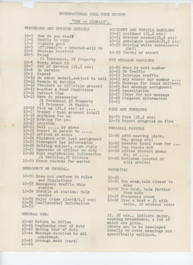
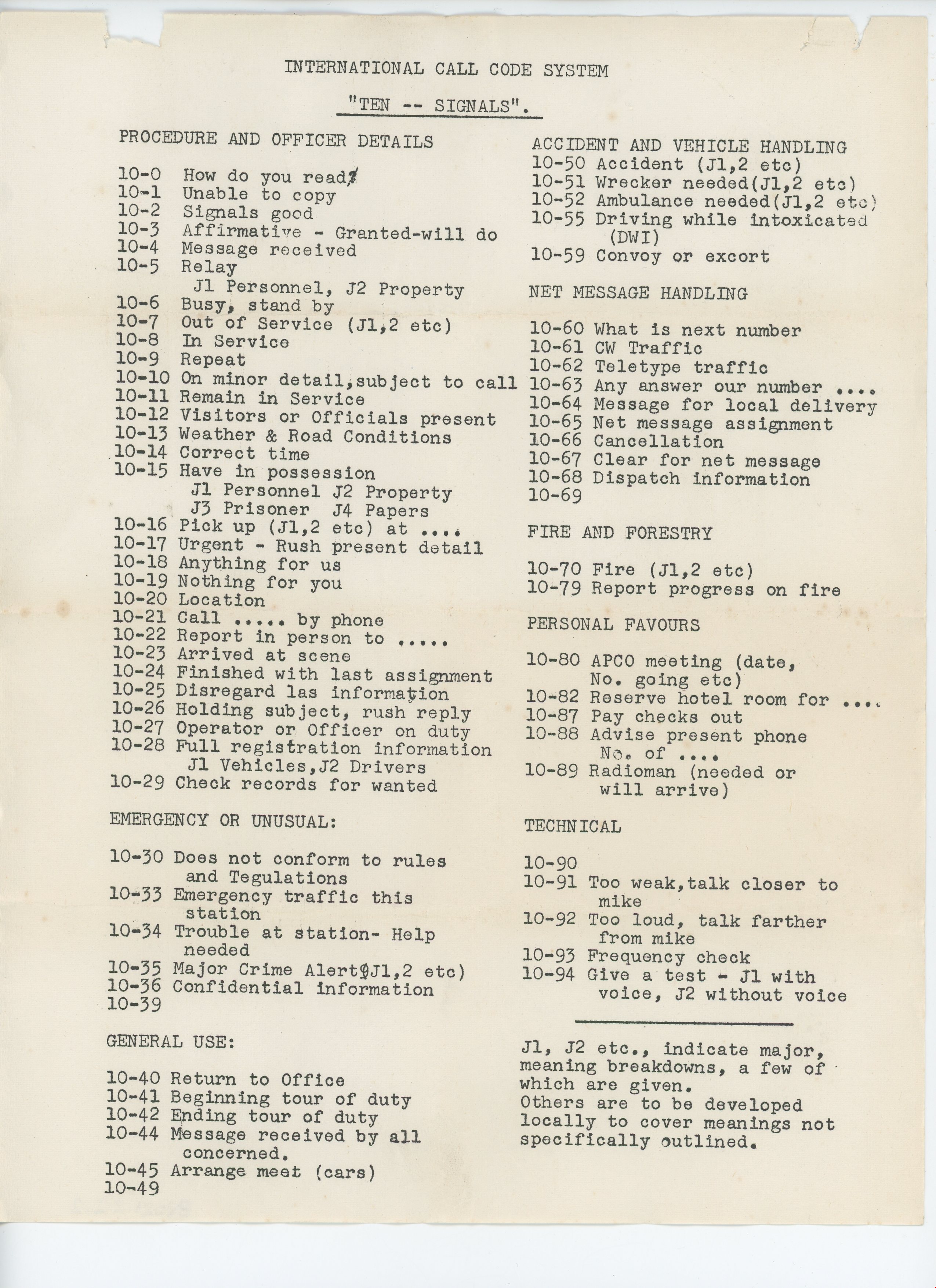
international call codes paper
https://search.heritageburnaby.ca/link/museumartifact91450
- Repository
- Burnaby Village Museum
- Accession Code
- BV021.22.2
- Description
- Paper listing several radio signals used by the Civil Defense department. Paper is creased and yellowing especially around edges and folds.
- Object History
- This “Ten – Signals” paper was donated alongside the audio-amplification set, belonging to Mr. Edward Fountain. The signals represented on the paper were used in training volunteers in the Burnaby Civil Defence Department, of which Mr. Fountain was named Director/ Coordinator in 1952. The Burnaby Civil Defense Department was established in order to disseminate information guiding the public on how to react in response to the impending threat of nuclear war and Russian bombers. In the early 1950’s, this education centered primarily on evacuation, as members of the public were expected to prepare and essentially fend for themselves in the event of a nuclear attack. Training took place throughout the City of Burnaby and in the surrounding regions, as the Civil Defence departments of several municipalities (namely the City of Vancouver and the City of New Westminster) partnered together in evacuation and recovery training, where the use of instructional training papers such as this would come into play.
- Category
- 08. Communication Artifacts
- Classification
- Visual Communication T&E
- Object Term
- Paperwork
- Colour
- White
- Measurements
- height: 28.2 cm width: 22 cm
- Subjects
- Communication Artifacts
- Names
- Fountain, Edward
- Geographic Access
- Burnaby Lake
- Planning Study Area
- Windsor Area
Images
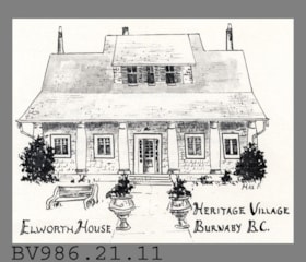
postcard
https://search.heritageburnaby.ca/link/museumartifact5636
- Repository
- Burnaby Village Museum
- Accession Code
- BV986.21.11
- Description
- Elworth House - Postcard - [197-?]. Advertising or souvenir card produced by Heritage Village Museum (Burnaby Village Museum) to promote Elworth House. The front of the card has an illustration by Max F of Elworth House. The back of the card gives a short description of Elworth House and its owner, Edwin Bateman.
- Classification
- Written Communication T&E - - Writing Media
- Object Term
- Postcard
- Geographic Access
- Deer Lake Avenue
- Street Address
- 6501 Deer Lake Avenue
- Historic Neighbourhood
- Burnaby Lake (Historic Neighbourhood)
- Planning Study Area
- Morley-Buckingham Area
Images


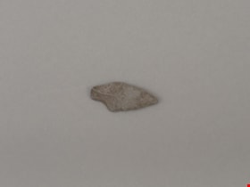
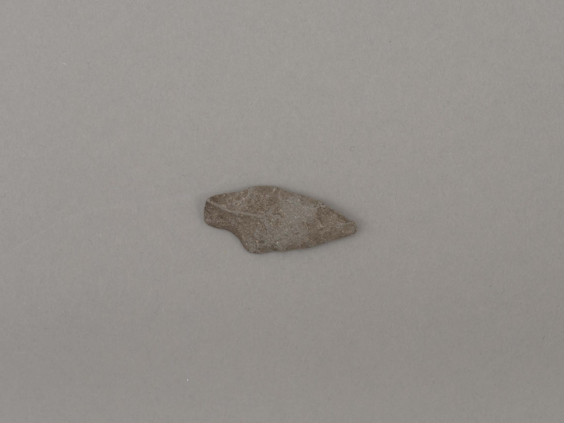
projectile point
https://search.heritageburnaby.ca/link/museumartifact19194
- Repository
- Burnaby Village Museum
- Accession Code
- BV002.57.7
- Description
- Projectile point, stone; indented on one side. Triangular stemmed projectile point
- Object History
- The donor inherited this artifact from his mother, Katherine Maude (Kitty) Peers, who inherited them from her father, Louis Claude Hill. The artifacts were found on his farm, Brookfield Farm, at Douglas Road and Sperling Avenue (now site of Burnaby Village Museum).
- Culture Phase: Possibly Locarno Beach phase (3520 -2200 Before Present)
- Geographic Access
- Deer Lake Avenue
- Historic Neighbourhood
- Burnaby Lake (Historic Neighbourhood)
- Planning Study Area
- Burnaby Lake Area
Images