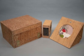
audio amplification set
https://search.heritageburnaby.ca/link/museumartifact91427
- Repository
- Burnaby Village Museum
- Accession Code
- BV021.22.1
- Description
- A large box containing a audio-amp, a wooden triangular prism with a decorative round speaker, and six smaller rectangular boxes. All are made of a light wood, and have different functions.
- Object History
- This audio-amplifier set was used by Mr. Edward A. Fountain, who was appointed as Civil Defense Coordinator on May 5th, 1952. He also built the wooden boxes which contain each part of the set. The Burnaby Civil Defense Department was established in order to disseminate information guiding the public on how to react in response to the impending threat of nuclear war and Russian bombers. In the early 1950’s, this education centered primarily on evacuation, as members of the public were expected to prepare and essentially fend for themselves in the event of a nuclear attack. These pieces of audio technology are believed to have been used at Civil Defense rallies in Burnaby, which Edward Fountain would have been involved in as the department director. According to Burnaby City Council meeting records, music and defense operation demonstrations were commonplace at such rallies, and are examples of what this set was used for.
- Classification
- Telecommunication T&E - - Telecommunication Devices
- Object Term
- Radio
- Colour
- Brown
- Country Made
- Canada
- Province Made
- British Columbia
- Site/City Made
- Burnaby
- Subjects
- Communication Artifacts
- Names
- Fountain, Edward
- Geographic Access
- Burnaby Lake
- Planning Study Area
- Windsor Area
Images
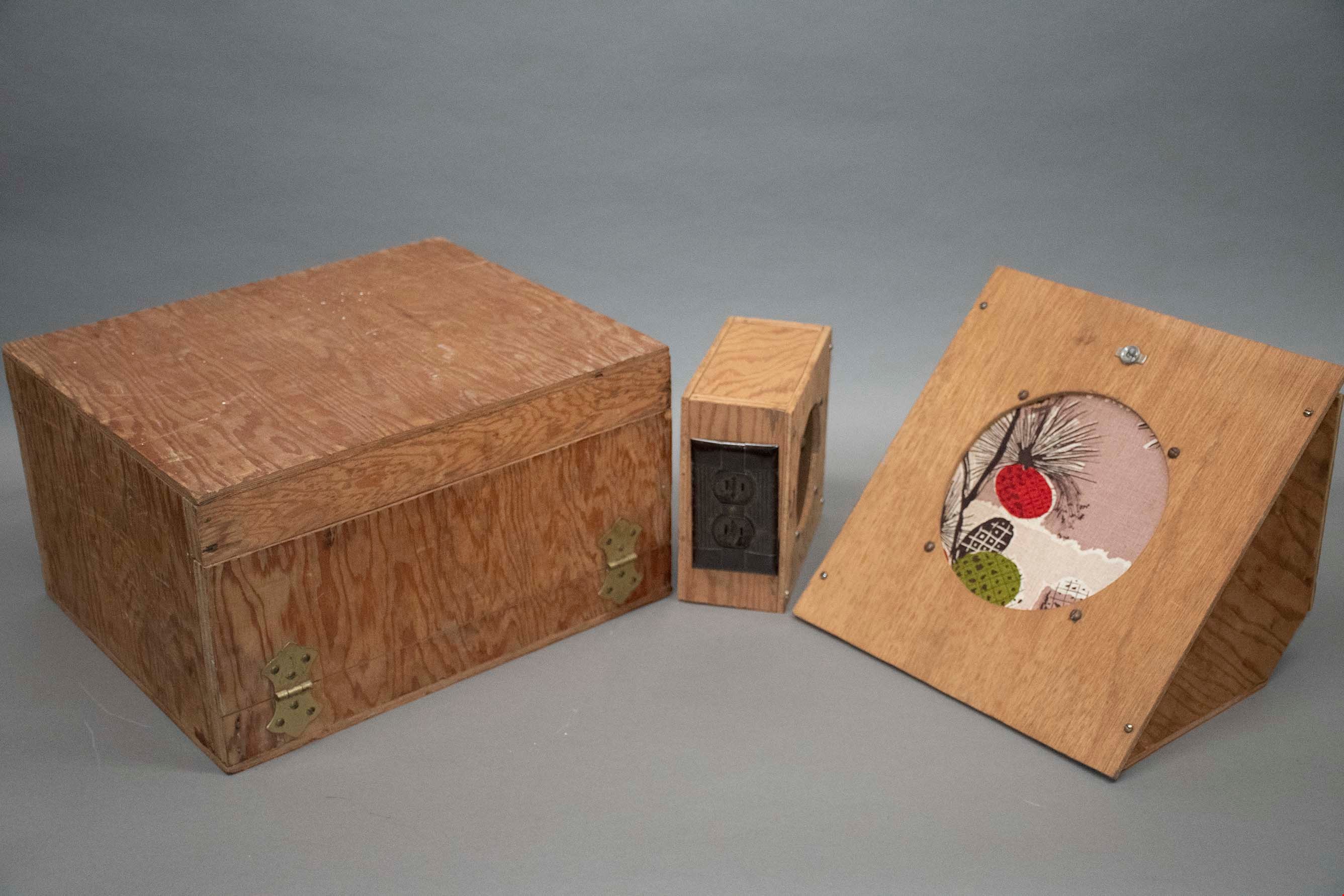
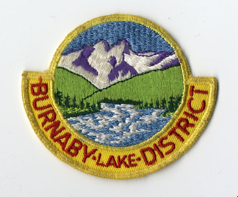
badge
https://search.heritageburnaby.ca/link/museumartifact48258
- Repository
- Burnaby Village Museum
- Accession Code
- BV005.13.41
- Description
- Badge, cloth, circular; yellow, green, white, red, blue; scene of mountains, river and field with a yellow bar across bottom with red lettering.
- Object History
- Scouts Canada
- Marks/Labels
- "BURNABY LAKE (smaller) DISTRICT", stitching, red
- Subjects
- Organizations
- Organizations - Boys' Societies and Clubs
- Personal Symbols
- Personal Symbols - Badges
- Geographic Access
- Burnaby Lake
Images

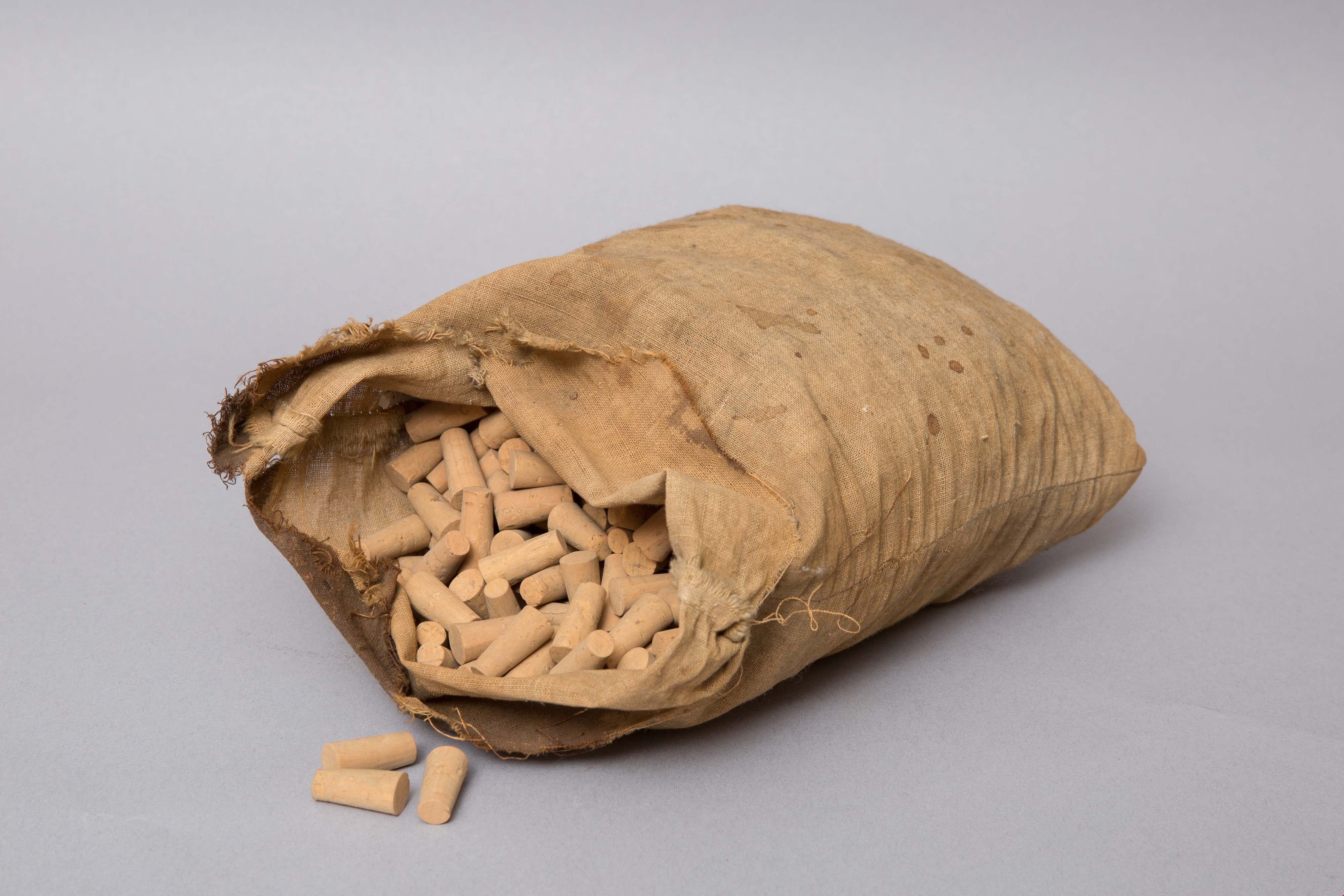
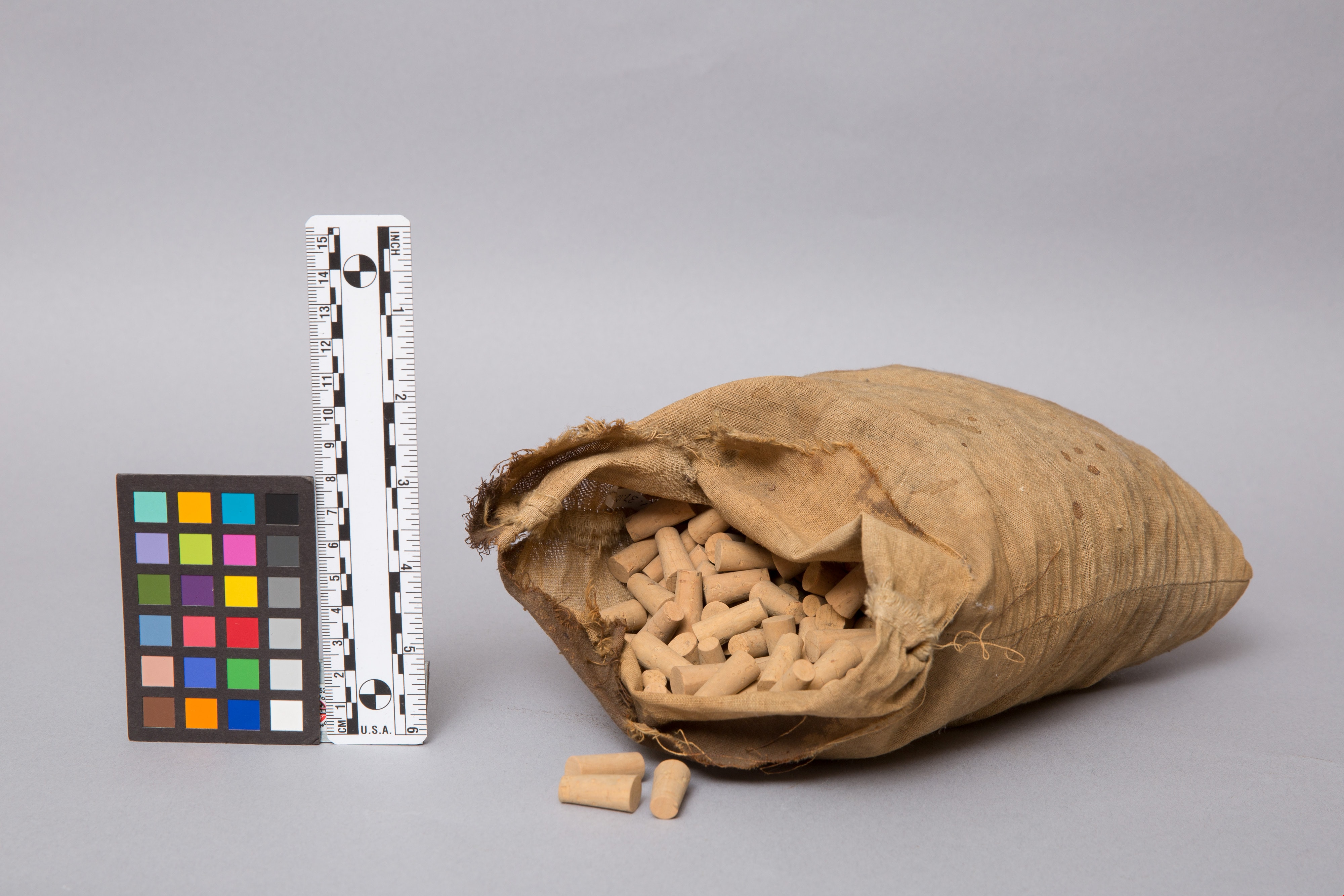
bag of corks
https://search.heritageburnaby.ca/link/museumartifact1328
- Repository
- Burnaby Village Museum
- Accession Code
- HV971.37.106
- Description
- Beige, flour sack-type cloth bag filled with unused corks. Open at top. Stitching along sides. Some stains on cloth.
- Object History
- This item originates from the Central Park Pharmacy in Burnaby.
- Classification
- Chemical T&E
- Marks/Labels
- no label found
- Names
- Central Park Pharmacy
- Geographic Access
- Central Park
- Historic Neighbourhood
- Central Park (Historic Neighbourhood)
- Planning Study Area
- Maywood Area
Images
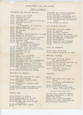
international call codes paper
https://search.heritageburnaby.ca/link/museumartifact91450
- Repository
- Burnaby Village Museum
- Accession Code
- BV021.22.2
- Description
- Paper listing several radio signals used by the Civil Defense department. Paper is creased and yellowing especially around edges and folds.
- Object History
- This “Ten – Signals” paper was donated alongside the audio-amplification set, belonging to Mr. Edward Fountain. The signals represented on the paper were used in training volunteers in the Burnaby Civil Defence Department, of which Mr. Fountain was named Director/ Coordinator in 1952. The Burnaby Civil Defense Department was established in order to disseminate information guiding the public on how to react in response to the impending threat of nuclear war and Russian bombers. In the early 1950’s, this education centered primarily on evacuation, as members of the public were expected to prepare and essentially fend for themselves in the event of a nuclear attack. Training took place throughout the City of Burnaby and in the surrounding regions, as the Civil Defence departments of several municipalities (namely the City of Vancouver and the City of New Westminster) partnered together in evacuation and recovery training, where the use of instructional training papers such as this would come into play.
- Category
- 08. Communication Artifacts
- Classification
- Visual Communication T&E
- Object Term
- Paperwork
- Colour
- White
- Measurements
- height: 28.2 cm width: 22 cm
- Subjects
- Communication Artifacts
- Names
- Fountain, Edward
- Geographic Access
- Burnaby Lake
- Planning Study Area
- Windsor Area
Images
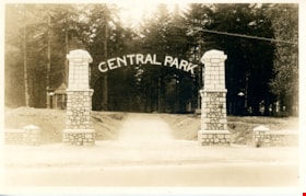
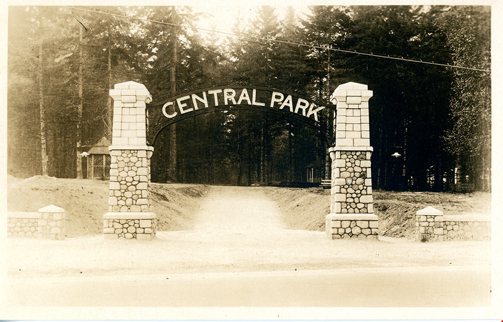
postcard
https://search.heritageburnaby.ca/link/museumartifact84668
- Repository
- Burnaby Village Museum
- Accession Code
- BV007.43.1
- Description
- postcard; black and white photograph of entrance arches to Central Park in Burnaby - [192-]. The postcard was published by the Gowen Sutton Company Limited of Vancouver, BC. Stamp in black ink on verso of postcard reads "PUBLISHED BY THE GOWEN SUTTON CO. LTD. VANCOUVER, B.C. / POSTCARD / CORRESPONDENCE_ADDRESS"
- Object History
- Souvenir postcard of Burnaby Central Park entrance arch.
- Classification
- Written Communication T&E - - Writing Media
- Object Term
- Postcard
- Colour
- Brown
- White
- Measurements
- w: 14 cm h: 9 cm
- Country Made
- Canada
- Province Made
- British Columbia
- Site/City Made
- Vancouver
- Subjects
- Structures - Arches
- Documentary Artifacts
- Documentary Artifacts - Postcards
- Geographic Features - Parks
- Geographic Access
- Central Park
- Imperial Street
- Street Address
- 3883 Imperial Street
- Historic Neighbourhood
- Central Park (Historic Neighbourhood)
- Planning Study Area
- Maywood Area
Images

Survey and Subdivision plans in New Westminster District Group 1 – Burnaby
https://search.heritageburnaby.ca/link/museumdescription6971
- Repository
- Burnaby Village Museum
- Date
- 1904-1908
- Collection/Fonds
- Burnaby Village Museum Map collection
- Description Level
- File
- Physical Description
- 7 plans : blueprint ink on paper mounted on 2 sides of cardboard 76 cm x 101.5 cm
- Scope and Content
- Item consists of a large board of four New Westminster District Gp 1 -subdivision plans mounted on one side and three New Westminster District Gp 1 - subdivision plans mounted on the other side. Side A: 1. Blueprint "Plan / of Subdivision of / Lot 28A / in Subdivision of / Lot 97, Group 1 / Ne…
- Repository
- Burnaby Village Museum
- Collection/Fonds
- Burnaby Village Museum Map collection
- Description Level
- File
- Physical Description
- 7 plans : blueprint ink on paper mounted on 2 sides of cardboard 76 cm x 101.5 cm
- Material Details
- Scales [between1:120 and 1:3960]
- Index number on edge of board reads: "3"
- Scope and Content
- Item consists of a large board of four New Westminster District Gp 1 -subdivision plans mounted on one side and three New Westminster District Gp 1 - subdivision plans mounted on the other side. Side A: 1. Blueprint "Plan / of Subdivision of / Lot 28A / in Subdivision of / Lot 97, Group 1 / New Westminster District". The B.C.E.R. is identified running through the subdivision of XXVIIIA (Lot 28A). Plan is dated "Sept. 21st, 08" (Geographic location: Burnaby) 2. Blueprint "Measurements / of Discharge / in Ditches / Lots 155A, G.One" / "Scale, Twentieths. / 17/12/04" (Geographic location: Burnaby) 3. Blueprint "Plan / of Subdivision / of a portion of / Lot 95 / Group One / New Westminster District" B.C. Electric Railway runs through the top of the plan. The plan is dated May 23, 1906. (Geographic location: Burnaby) 4. Blueprint " Profile / on Water Surface / in / Holland Road Ditch / Woollard's Ditch / Dec. 3rd 1904 / Scales Hor. 200'=1" / Vert. 10'=1"" (Geographic location: Burnaby) Side B: 1. Blueprint " "Sunnyside Park" / plan of Subdivision / of / the East Half / of / Lot 39, GR.One, / New Westminster District / Scale 100'=1" (Geographic location: Burnaby) 2. Blueprint " "Sunnyside Park"/ plan of Subdivi..n / of / Lot 39, Gr.1. / New Westminster District" Index in upper left corner of plan shows location of Lot 39 in relation to Central Park and surrounding Lots. (Geographic location: Burnaby) 3. Blueprint "Plan / of Subdivision / of / Lot 163 and 165 / Group One / New Westminster District / Scale 5 chs=1 in." Streets within subdivision plan are identified as; North Arm Road, Ingram Street, Blair Street, Kennedy Street, Murray Street, Wiggins Road, Byrne Road, South Road along with North Arm Fraser River and B.C. Electric Railway. (Geographic location: Burnaby)
- Geographic Access
- Central Park
- Accession Code
- HV977.93.3
- Access Restriction
- No restrictions
- Reproduction Restriction
- No known restrictions
- Date
- 1904-1908
- Media Type
- Cartographic Material
- Historic Neighbourhood
- Central Park (Historic Neighbourhood)
- Scan Resolution
- 300
- Scale
- 72
- Notes
- Title based on contents of file
- Scale is measured in chains and feet. (One chain equals 792 inches)
- The term "Lot" can also refer to a "District Lot”
Images

