Narrow Results By
Subject
- Advertising Medium - Signs and Signboards 2
- Agriculture - Farms 54
- Animals - Cows 4
- Animals - Dogs 1
- Animals - Horses 11
- Animals - Poultry 1
- Buildings - Agricultural - Barns 5
- Buildings - Agricultural - Stables 1
- Buildings - Commercial - General Stores 1
- Buildings - Commercial - Hotels and Motels 1
- Buildings - Commercial - Service Stations 3
- Buildings - Commercial - Train Stations 3
![Aliceville Hotel, [1892] thumbnail](/media/hpo/_Data/_Archives_Images/_Unrestricted/371/421-001.jpg?width=280)
Aliceville Hotel
https://search.heritageburnaby.ca/link/archivedescription38369
- Repository
- City of Burnaby Archives
- Date
- [1892]
- Collection/Fonds
- Burnaby Historical Society fonds
- Description Level
- Item
- Physical Description
- 1 photograph : b&w ; 10 x 12.5 cm
- Scope and Content
- Photograph of the Aliceville Hotel at Burrard Inlet which was built in 1892. On the back of the photograph, a map showing the hotel's location in relation to Hastings Street and North Road has been sketched in pencil.
- Repository
- City of Burnaby Archives
- Date
- [1892]
- Collection/Fonds
- Burnaby Historical Society fonds
- Subseries
- Photographs subseries
- Physical Description
- 1 photograph : b&w ; 10 x 12.5 cm
- Description Level
- Item
- Record No.
- 421-001
- Access Restriction
- No restrictions
- Reproduction Restriction
- No known restrictions
- Accession Number
- BHS2001-10
- Scope and Content
- Photograph of the Aliceville Hotel at Burrard Inlet which was built in 1892. On the back of the photograph, a map showing the hotel's location in relation to Hastings Street and North Road has been sketched in pencil.
- Names
- Aliceville Hotel
- Media Type
- Photograph
- Notes
- Title based on contents of photograph
- Geographic Access
- Hastings Street
- Barnet Road
- Street Address
- 9951 Barnet Road
- Planning Study Area
- Burnaby Mountain Area
Images
![Aliceville Hotel, [1892] thumbnail](/media/hpo/_Data/_Archives_Images/_Unrestricted/371/421-001.jpg)
![A Pretty Dwelling, Barnet B.C., [1907] thumbnail](/media/hpo/_Data/_Archives_Images/_Unrestricted/371/411-008.jpg?width=280)
A Pretty Dwelling, Barnet B.C.
https://search.heritageburnaby.ca/link/archivedescription38349
- Repository
- City of Burnaby Archives
- Date
- [1907]
- Collection/Fonds
- Burnaby Historical Society fonds
- Description Level
- Item
- Physical Description
- 1 photograph : sepia postcard ; 8.5 x 14 cm
- Scope and Content
- Photograph of the front garden and exterior of the North Pacific Lumber Co. (NPLC) Manager's house at Barnet. The caption on the card reads: "A Pretty Dwelling, Barnet B.C."
- Repository
- City of Burnaby Archives
- Date
- [1907]
- Collection/Fonds
- Burnaby Historical Society fonds
- Subseries
- Charles Lee subseries
- Physical Description
- 1 photograph : sepia postcard ; 8.5 x 14 cm
- Description Level
- Item
- Record No.
- 411-008
- Access Restriction
- No restrictions
- Reproduction Restriction
- No known restrictions
- Accession Number
- BHS2000-13
- Scope and Content
- Photograph of the front garden and exterior of the North Pacific Lumber Co. (NPLC) Manager's house at Barnet. The caption on the card reads: "A Pretty Dwelling, Barnet B.C."
- Media Type
- Photograph
- Notes
- Title taken from caption
- Geographic Access
- Barnet Village
- Barnet Road
- Street Address
- 8181 Barnet Road
- Historic Neighbourhood
- Barnet (Historic Neighbourhood)
- Planning Study Area
- Burnaby Mountain Area
Images
![A Pretty Dwelling, Barnet B.C., [1907] thumbnail](/media/hpo/_Data/_Archives_Images/_Unrestricted/371/411-008.jpg)
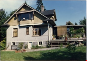
Back of Mawhinney house
https://search.heritageburnaby.ca/link/museumdescription15558
- Repository
- Burnaby Village Museum
- Date
- 1987
- Collection/Fonds
- Reverend Edward S. Gale fonds
- Description Level
- Item
- Physical Description
- 1 photograph : col. ; 9 x 12.5 cm
- Scope and Content
- Photograph of the back of the Mawhinney house located at 7667 Burris Street in Burnaby. A large back porch (deck) is attached to the right side of the house.
- Repository
- Burnaby Village Museum
- Collection/Fonds
- Reverend Edward S. Gale fonds
- Description Level
- Item
- Physical Description
- 1 photograph : col. ; 9 x 12.5 cm
- Scope and Content
- Photograph of the back of the Mawhinney house located at 7667 Burris Street in Burnaby. A large back porch (deck) is attached to the right side of the house.
- Geographic Access
- Burris Street
- Street Address
- 7667 Burris Street
- Accession Code
- BV018.9.44
- Access Restriction
- No restrictions
- Reproduction Restriction
- May be restricted by third party rights
- Date
- 1987
- Media Type
- Photograph
- Planning Study Area
- Morley-Buckingham Area
- Scan Resolution
- 600
- Scan Date
- April 15, 2021
- Scale
- 100
- Notes
- Title based on contents of photograph
Images

Back of Mawhinney house
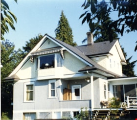
https://search.heritageburnaby.ca/link/museumdescription15560
- Repository
- Burnaby Village Museum
- Date
- 1988
- Collection/Fonds
- Reverend Edward S. Gale fonds
- Description Level
- Item
- Physical Description
- 1 photograph : col. ; 9 x 12.5 cm
- Scope and Content
- Photograph of the back of the Mawhinney house located at 7667 Burris Street in Burnaby. A large back porch (deck) is attached to the right side of the house. Photograph was taken after the house was painted.
- Repository
- Burnaby Village Museum
- Collection/Fonds
- Reverend Edward S. Gale fonds
- Description Level
- Item
- Physical Description
- 1 photograph : col. ; 9 x 12.5 cm
- Scope and Content
- Photograph of the back of the Mawhinney house located at 7667 Burris Street in Burnaby. A large back porch (deck) is attached to the right side of the house. Photograph was taken after the house was painted.
- Geographic Access
- Burris Street
- Street Address
- 7667 Burris Street
- Accession Code
- BV018.9.26
- Access Restriction
- No restrictions
- Reproduction Restriction
- May be restricted by third party rights
- Date
- 1988
- Media Type
- Photograph
- Planning Study Area
- Morley-Buckingham Area
- Related Material
- See also BV018.9.44
- Scan Resolution
- 600
- Scan Date
- April 20, 2021
- Scale
- 100
- Notes
- Title based on contents of photograph
Images

![Back of the Barnet School, [between 1911 and 1919] thumbnail](/media/hpo/_Data/_Archives_Images/_Unrestricted/316/325-019.jpg?width=280)
Back of the Barnet School
https://search.heritageburnaby.ca/link/archivedescription37147
- Repository
- City of Burnaby Archives
- Date
- [between 1911 and 1919]
- Collection/Fonds
- Burnaby Historical Society fonds
- Description Level
- Item
- Physical Description
- 1 photograph : b&w ; 8.5 x 12.5 cm print
- Scope and Content
- Photograph of the back of the Barnet School and its adjoining teacher's residence.
- Repository
- City of Burnaby Archives
- Date
- [between 1911 and 1919]
- Collection/Fonds
- Burnaby Historical Society fonds
- Subseries
- Disney family subseries
- Physical Description
- 1 photograph : b&w ; 8.5 x 12.5 cm print
- Description Level
- Item
- Record No.
- 325-019
- Access Restriction
- No restrictions
- Reproduction Restriction
- No known restrictions
- Accession Number
- BHS1996-04
- Scope and Content
- Photograph of the back of the Barnet School and its adjoining teacher's residence.
- Subjects
- Buildings - Schools
- Names
- Barnet School
- Media Type
- Photograph
- Photographer
- Disney, John Harold "Jack"
- Notes
- Title based on contents of photograph
- Geographic Access
- Barnet Road
- Street Address
- 7820 Barnet Road
- Historic Neighbourhood
- Barnet (Historic Neighbourhood)
- Planning Study Area
- Burnaby Mountain Area
Images
![Back of the Barnet School, [between 1911 and 1919] thumbnail](/media/hpo/_Data/_Archives_Images/_Unrestricted/316/325-019.jpg)
Back yard of Mawhinney house
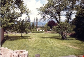
https://search.heritageburnaby.ca/link/museumdescription15561
- Repository
- Burnaby Village Museum
- Date
- August 1984
- Collection/Fonds
- Reverend Edward S. Gale fonds
- Description Level
- Item
- Physical Description
- 1 photograph : col. ; 10 x 15 cm
- Scope and Content
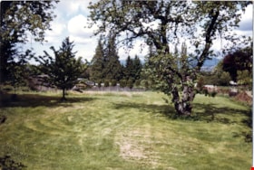
- Photograph of the back yard of the Mervin Mawhinney house looking north from the back deck before any of the subsequent landscaping was done by Reverend Gale. Tree on the right is a cherry tree. The house is located at 7667 Burris Street.
- Repository
- Burnaby Village Museum
- Collection/Fonds
- Reverend Edward S. Gale fonds
- Description Level
- Item
- Physical Description
- 1 photograph : col. ; 10 x 15 cm
- Scope and Content
- Photograph of the back yard of the Mervin Mawhinney house looking north from the back deck before any of the subsequent landscaping was done by Reverend Gale. Tree on the right is a cherry tree. The house is located at 7667 Burris Street.
- Geographic Access
- Burris Street
- Street Address
- 7667 Burris Street
- Accession Code
- BV018.9.27
- Access Restriction
- No restrictions
- Reproduction Restriction
- May be restricted by third party rights
- Date
- August 1984
- Media Type
- Photograph
- Planning Study Area
- Morley-Buckingham Area
- Scan Resolution
- 600
- Scan Date
- April 20, 2021
- Scale
- 100
- Notes
- Title based on contents of photograph
- Note in black ink on verso of photograph reads: "August '84"
Images

Back yard of Mawhinney house
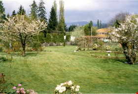
https://search.heritageburnaby.ca/link/museumdescription15562
- Repository
- Burnaby Village Museum
- Date
- 1990
- Collection/Fonds
- Reverend Edward S. Gale fonds
- Description Level
- Item
- Physical Description
- 1 photograph : col. ; 10 x 15 cm
- Scope and Content
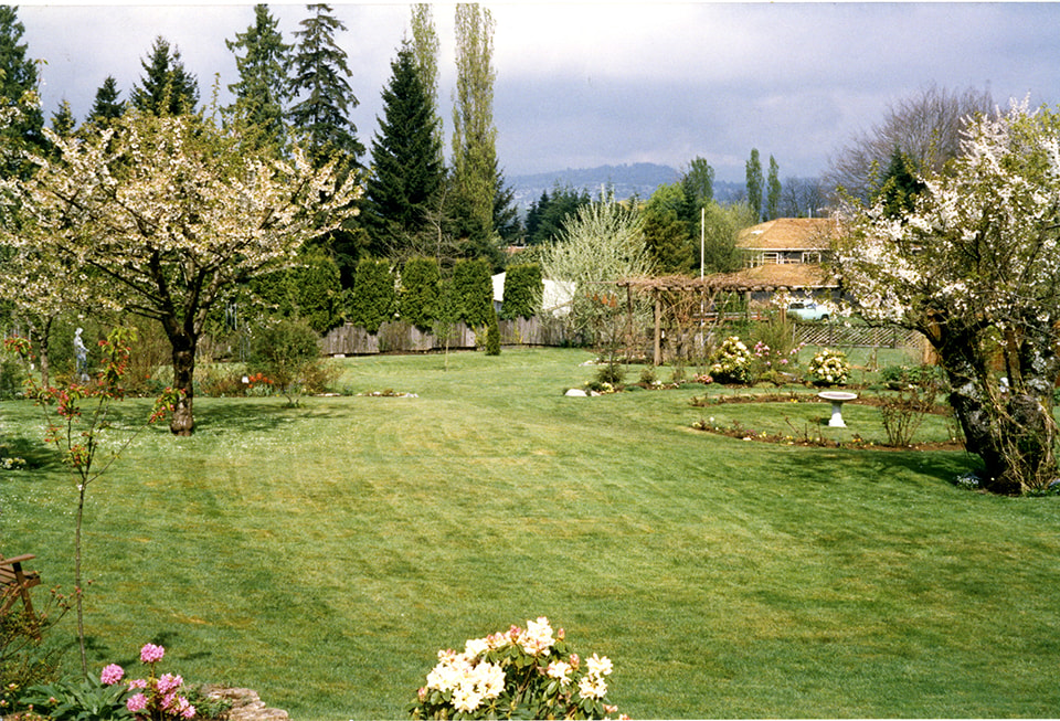
- Photograph of the back yard of the Mervin Mawhinney house looking north from the back deck after landscaping was done by owner Reverend Gale. Cherry trees, rhododendrons and gardens are visible. The house is located at 7667 Burris Street.
- Repository
- Burnaby Village Museum
- Collection/Fonds
- Reverend Edward S. Gale fonds
- Description Level
- Item
- Physical Description
- 1 photograph : col. ; 10 x 15 cm
- Scope and Content
- Photograph of the back yard of the Mervin Mawhinney house looking north from the back deck after landscaping was done by owner Reverend Gale. Cherry trees, rhododendrons and gardens are visible. The house is located at 7667 Burris Street.
- Geographic Access
- Burris Street
- Street Address
- 7667 Burris Street
- Accession Code
- BV018.9.28
- Access Restriction
- No restrictions
- Reproduction Restriction
- May be restricted by third party rights
- Date
- 1990
- Media Type
- Photograph
- Planning Study Area
- Morley-Buckingham Area
- Scan Resolution
- 600
- Scan Date
- April 20, 2021
- Scale
- 100
- Notes
- Title based on contents of photograph
Images
Back yard of Mawhinney house
https://search.heritageburnaby.ca/link/museumdescription15563
- Repository
- Burnaby Village Museum
- Date
- August 1984
- Collection/Fonds
- Reverend Edward S. Gale fonds
- Description Level
- Item
- Physical Description
- 1 photograph : col. ; 10 x 15 cm
- Scope and Content
- Photograph of the back yard of the Mervin Mawhinney house looking north from the back deck before any of the subsequent landscaping was done by Reverend Gale. Tree on the right is a cherry tree. The house is located at 7667 Burris Street.
- Repository
- Burnaby Village Museum
- Collection/Fonds
- Reverend Edward S. Gale fonds
- Description Level
- Item
- Physical Description
- 1 photograph : col. ; 10 x 15 cm
- Scope and Content
- Photograph of the back yard of the Mervin Mawhinney house looking north from the back deck before any of the subsequent landscaping was done by Reverend Gale. Tree on the right is a cherry tree. The house is located at 7667 Burris Street.
- Geographic Access
- Burris Street
- Street Address
- 7667 Burris Street
- Accession Code
- BV018.9.29
- Access Restriction
- No restrictions
- Reproduction Restriction
- May be restricted by third party rights
- Date
- August 1984
- Media Type
- Photograph
- Planning Study Area
- Morley-Buckingham Area
- Scan Resolution
- 600
- Scan Date
- April 20, 2021
- Scale
- 100
- Notes
- Title based on contents of photograph
Images
Back yard of Mawhinney house
https://search.heritageburnaby.ca/link/museumdescription15565
- Repository
- Burnaby Village Museum
- Date
- August 1984
- Collection/Fonds
- Reverend Edward S. Gale fonds
- Description Level
- Item
- Physical Description
- 1 photograph : col. ; 10 x 15 cm
- Scope and Content
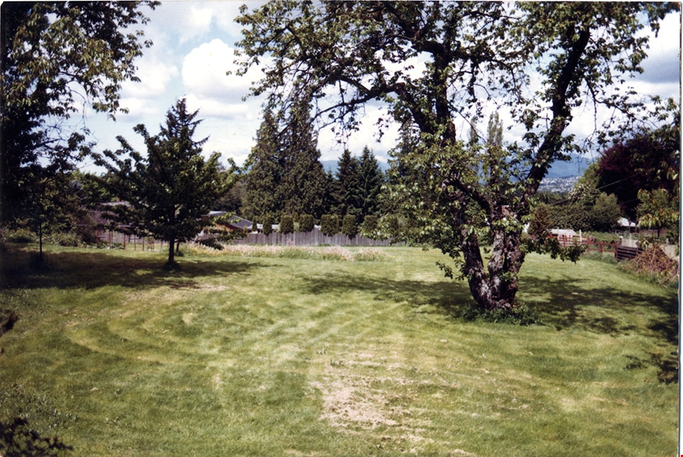
- Photograph of the back yard of the Mervin Mawhinney house located at 7667 Burris Street in Burnaby. A large cherry tree is in the centre of the photograph and a row of rectangular garden beds are visible in the background along with a wooden fence and neighbouring house.
- Repository
- Burnaby Village Museum
- Collection/Fonds
- Reverend Edward S. Gale fonds
- Description Level
- Item
- Physical Description
- 1 photograph : col. ; 10 x 15 cm
- Scope and Content
- Photograph of the back yard of the Mervin Mawhinney house located at 7667 Burris Street in Burnaby. A large cherry tree is in the centre of the photograph and a row of rectangular garden beds are visible in the background along with a wooden fence and neighbouring house.
- Geographic Access
- Burris Street
- Street Address
- 7667 Burris Street
- Accession Code
- BV018.9.31
- Access Restriction
- No restrictions
- Reproduction Restriction
- May be restricted by third party rights
- Date
- August 1984
- Media Type
- Photograph
- Planning Study Area
- Morley-Buckingham Area
- Scan Resolution
- 600
- Scan Date
- April 15, 2021
- Scale
- 100
- Notes
- Title based on contents of photograph
Images
Back yard of the Mervin Mawhinney house looking north west
https://search.heritageburnaby.ca/link/museumdescription5208
- Repository
- Burnaby Village Museum
- Date
- 1962
- Collection/Fonds
- Reverend Edward S. Gale fonds
- Description Level
- Item
- Physical Description
- 1 photograph : col. ; 10 x 15.2 cm print
- Scope and Content
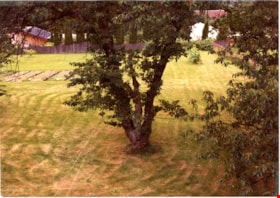
- Photograph of the back yard of the Mervin Mawhinney house looking north west. The ground is covered with snow. Two bare deciduous trees in foreground. The address of the house was 7661 Burris Street and was changed to 7667 Burris Street in 1984.
- Repository
- Burnaby Village Museum
- Collection/Fonds
- Reverend Edward S. Gale fonds
- Description Level
- Item
- Physical Description
- 1 photograph : col. ; 10 x 15.2 cm print
- Scope and Content
- Photograph of the back yard of the Mervin Mawhinney house looking north west. The ground is covered with snow. Two bare deciduous trees in foreground. The address of the house was 7661 Burris Street and was changed to 7667 Burris Street in 1984.
- Subjects
- Natural Phenomena - Snow
- Geographic Access
- Burris Street
- Street Address
- 7667 Burris Street
- Accession Code
- BV018.9.8
- Access Restriction
- No restrictions
- Reproduction Restriction
- May be restricted by third party rights
- Date
- 1962
- Media Type
- Photograph
- Planning Study Area
- Morley-Buckingham Area
- Scan Resolution
- 600
- Scan Date
- 07-05-2018
- Photographer
- Weller, Michael
- Notes
- Title based on contents of photograph
- "Dec. '62 / looking N. west" written in pen on verso.
Images

Barn at Lubbock's farm
https://search.heritageburnaby.ca/link/archivedescription36520
- Repository
- City of Burnaby Archives
- Date
- 1977
- Collection/Fonds
- Burnaby Historical Society fonds
- Description Level
- Item
- Physical Description
- 1 photograph : col. ; 9 x 8.5 cm
- Scope and Content
- Photograph of the horse barn at Lubbock's farm. Both the Burnaby Lake Riding Academy and the Burnaby Lake Saddle Club operated out of the Lubbock farm.
- Repository
- City of Burnaby Archives
- Date
- 1977
- Collection/Fonds
- Burnaby Historical Society fonds
- Subseries
- Lubbock family subseries
- Physical Description
- 1 photograph : col. ; 9 x 8.5 cm
- Description Level
- Item
- Record No.
- 289-009
- Access Restriction
- No restrictions
- Reproduction Restriction
- Reproduce for fair dealing purposes only
- Accession Number
- BHS1992-24
- Scope and Content
- Photograph of the horse barn at Lubbock's farm. Both the Burnaby Lake Riding Academy and the Burnaby Lake Saddle Club operated out of the Lubbock farm.
- Subjects
- Buildings - Agricultural - Barns
- Media Type
- Photograph
- Notes
- Title based on contents of photograph
- Geographic Access
- Grandview Highway
- Canada Way
- Burris Street
- Street Address
- 7803 Burris Street
- Historic Neighbourhood
- Burnaby Lake (Historic Neighbourhood)
- Planning Study Area
- Morley-Buckingham Area
Images


Barnet Rifle Club
https://search.heritageburnaby.ca/link/archivedescription79712
- Repository
- City of Burnaby Archives
- Date
- September 12, 1976
- Collection/Fonds
- Burnaby Public Library Contemporary Visual Archive Project
- Description Level
- Item
- Physical Description
- 1 photograph : b&w ; 11 x 16 cm mounted on cardboard
- Scope and Content
- Photograph shows the sign at the entrance to the Barnet Rifle Club and the Rifle Range at 8550 Barnet Road.
- Repository
- City of Burnaby Archives
- Date
- September 12, 1976
- Collection/Fonds
- Burnaby Public Library Contemporary Visual Archive Project
- Physical Description
- 1 photograph : b&w ; 11 x 16 cm mounted on cardboard
- Description Level
- Item
- Record No.
- 556-396
- Access Restriction
- No restrictions
- Reproduction Restriction
- Reproduce for fair dealing purposes only
- Accession Number
- 2013-13
- Scope and Content
- Photograph shows the sign at the entrance to the Barnet Rifle Club and the Rifle Range at 8550 Barnet Road.
- Names
- Barnet Rifle Club
- Media Type
- Photograph
- Notes
- Scope note taken directly from BPL photograph description.
- 1 b&w copy negative : 10 x 12.5 cm accompanying
- Photographers identified by surnames only: Carr and Vardeman
- Geographic Access
- Barnet Road
- Street Address
- 8550 Barnet Road
- Historic Neighbourhood
- Barnet (Historic Neighbourhood)
- Planning Study Area
- Burnaby Mountain Area
Images


Barnet Rifle Club
https://search.heritageburnaby.ca/link/archivedescription79713
- Repository
- City of Burnaby Archives
- Date
- September, 1976
- Collection/Fonds
- Burnaby Public Library Contemporary Visual Archive Project
- Description Level
- Item
- Physical Description
- 1 photograph : b&w ; 11 x 16 cm mounted on cardboard
- Scope and Content
- Photograph shows a man ascending the steps of the Barnet Rifle Club Clubhouse.
- Repository
- City of Burnaby Archives
- Date
- September, 1976
- Collection/Fonds
- Burnaby Public Library Contemporary Visual Archive Project
- Physical Description
- 1 photograph : b&w ; 11 x 16 cm mounted on cardboard
- Description Level
- Item
- Record No.
- 556-397
- Access Restriction
- No restrictions
- Reproduction Restriction
- Reproduce for fair dealing purposes only
- Accession Number
- 2013-13
- Scope and Content
- Photograph shows a man ascending the steps of the Barnet Rifle Club Clubhouse.
- Names
- Barnet Rifle Club
- Media Type
- Photograph
- Notes
- Scope note taken directly from BPL photograph description.
- 1 b&w copy negative : 10 x 12.5 cm accompanying
- Photographers identified by surnames only: Carr and Vardeman
- Geographic Access
- Barnet Road
- Street Address
- 8550 Barnet Road
- Historic Neighbourhood
- Barnet (Historic Neighbourhood)
- Planning Study Area
- Burnaby Mountain Area
Images


Barnet Rifle Club
https://search.heritageburnaby.ca/link/archivedescription79714
- Repository
- City of Burnaby Archives
- Date
- September 12, 1976
- Collection/Fonds
- Burnaby Public Library Contemporary Visual Archive Project
- Description Level
- Item
- Physical Description
- 1 photograph : b&w ; 11 x 16 cm mounted on cardboard
- Scope and Content
- Photograph shows the covered firing line at the Barnet Rifle Range.
- Repository
- City of Burnaby Archives
- Date
- September 12, 1976
- Collection/Fonds
- Burnaby Public Library Contemporary Visual Archive Project
- Physical Description
- 1 photograph : b&w ; 11 x 16 cm mounted on cardboard
- Description Level
- Item
- Record No.
- 556-398
- Access Restriction
- No restrictions
- Reproduction Restriction
- Reproduce for fair dealing purposes only
- Accession Number
- 2013-13
- Scope and Content
- Photograph shows the covered firing line at the Barnet Rifle Range.
- Names
- Barnet Rifle Club
- Media Type
- Photograph
- Notes
- Scope note taken directly from BPL photograph description.
- 1 b&w copy negative : 10 x 12.5 cm accompanying
- Photographers identified by surnames only: Carr and Vardeman
- Geographic Access
- Barnet Road
- Street Address
- 8550 Barnet Road
- Historic Neighbourhood
- Barnet (Historic Neighbourhood)
- Planning Study Area
- Burnaby Mountain Area
Images


Barnet Rifle Club
https://search.heritageburnaby.ca/link/archivedescription79716
- Repository
- City of Burnaby Archives
- Date
- September 12, 1976
- Collection/Fonds
- Burnaby Public Library Contemporary Visual Archive Project
- Description Level
- Item
- Physical Description
- 1 photograph : b&w ; 11 x 16 cm mounted on cardboard
- Scope and Content
- Photograph shows two men shooting at targets on the Barnet Rifle Range.
- Repository
- City of Burnaby Archives
- Date
- September 12, 1976
- Collection/Fonds
- Burnaby Public Library Contemporary Visual Archive Project
- Physical Description
- 1 photograph : b&w ; 11 x 16 cm mounted on cardboard
- Description Level
- Item
- Record No.
- 556-399
- Access Restriction
- No restrictions
- Reproduction Restriction
- Reproduce for fair dealing purposes only
- Accession Number
- 2013-13
- Scope and Content
- Photograph shows two men shooting at targets on the Barnet Rifle Range.
- Names
- Barnet Rifle Club
- Media Type
- Photograph
- Notes
- Scope note taken directly from BPL photograph description.
- 1 b&w copy negative : 10 x 12.5 cm accompanying
- Photographers identified by surnames only: Carr and Vardeman
- Geographic Access
- Barnet Road
- Street Address
- 8550 Barnet Road
- Historic Neighbourhood
- Barnet (Historic Neighbourhood)
- Planning Study Area
- Burnaby Mountain Area
Images

![Barnet Road, [1914 or 1915] thumbnail](/media/hpo/_Data/_Archives_Images/_Unrestricted/001/044-001.jpg?width=280)
Barnet Road
https://search.heritageburnaby.ca/link/archivedescription34541
- Repository
- City of Burnaby Archives
- Date
- [1914 or 1915]
- Collection/Fonds
- Burnaby Historical Society fonds
- Description Level
- Item
- Physical Description
- 1 photograph : b&w ; 16.4 x 21.3 cm
- Scope and Content
- Photograph of Barnet Road at North Road. Street signs on the left side of the photograph read, "North Ave" and "Barnet Road." A person on a motorbike or bicycle can be seen on the road in the distance. Utility poles are along the road.
- Repository
- City of Burnaby Archives
- Date
- [1914 or 1915]
- Collection/Fonds
- Burnaby Historical Society fonds
- Subseries
- Photographs subseries
- Physical Description
- 1 photograph : b&w ; 16.4 x 21.3 cm
- Description Level
- Item
- Record No.
- 044-001
- Access Restriction
- No restrictions
- Reproduction Restriction
- No known restrictions
- Accession Number
- BHS2007-04
- Scope and Content
- Photograph of Barnet Road at North Road. Street signs on the left side of the photograph read, "North Ave" and "Barnet Road." A person on a motorbike or bicycle can be seen on the road in the distance. Utility poles are along the road.
- Subjects
- Geographic Features - Roads
- Media Type
- Photograph
- Notes
- Title based on contents of photograph
- Geographic Access
- Barnet Road
- North Road
- Planning Study Area
- Burnaby Mountain Area
Images
![Barnet Road, [1914 or 1915] thumbnail](/media/hpo/_Data/_Archives_Images/_Unrestricted/001/044-001.jpg)

Barnet Road
https://search.heritageburnaby.ca/link/archivedescription35634
- Repository
- City of Burnaby Archives
- Date
- 1922 (date of original), copied 1986
- Collection/Fonds
- Burnaby Historical Society fonds
- Description Level
- Item
- Physical Description
- 1 photograph : b&w ; 12.7 x 17.8 cm print
- Scope and Content
- Photograph of Robert Woolsey carrying his daughter, Margaret, piggy-back along Barnet Road. Note the planked surface. Margaret was two years old at the time. In the upper right corner of the photograph is the Barnet School caretaker's cottage, located beside Barnet School at 7820 Barnet Road.
- Repository
- City of Burnaby Archives
- Date
- 1922 (date of original), copied 1986
- Collection/Fonds
- Burnaby Historical Society fonds
- Subseries
- Pioneer Tales subseries
- Physical Description
- 1 photograph : b&w ; 12.7 x 17.8 cm print
- Description Level
- Item
- Record No.
- 204-492
- Access Restriction
- No restrictions
- Reproduction Restriction
- No known restrictions
- Accession Number
- BHS1988-03
- Scope and Content
- Photograph of Robert Woolsey carrying his daughter, Margaret, piggy-back along Barnet Road. Note the planked surface. Margaret was two years old at the time. In the upper right corner of the photograph is the Barnet School caretaker's cottage, located beside Barnet School at 7820 Barnet Road.
- Subjects
- Geographic Features - Roads
- Media Type
- Photograph
- Notes
- Title based on contents of photograph
- Geographic Access
- Barnet Road
- Street Address
- 7820 Barnet Road
- Historic Neighbourhood
- Barnet (Historic Neighbourhood)
- Planning Study Area
- Burnaby Mountain Area
Images


Barnet Road
https://search.heritageburnaby.ca/link/archivedescription35635
- Repository
- City of Burnaby Archives
- Date
- 1921 (date of original), copied 1986
- Collection/Fonds
- Burnaby Historical Society fonds
- Description Level
- Item
- Physical Description
- 1 photograph : b&w ; 12.7 x 17.8 cm print
- Scope and Content
- Photograph of Barnet Road covered with November snows. The road was always treacherous in winter with snow and rock slides. In the upper right corner of the photograph is Barnet School and caretaker's cottage. Barnet School was located at 7820 Barnet Road.
- Repository
- City of Burnaby Archives
- Date
- 1921 (date of original), copied 1986
- Collection/Fonds
- Burnaby Historical Society fonds
- Subseries
- Pioneer Tales subseries
- Physical Description
- 1 photograph : b&w ; 12.7 x 17.8 cm print
- Description Level
- Item
- Record No.
- 204-493
- Access Restriction
- No restrictions
- Reproduction Restriction
- No known restrictions
- Accession Number
- BHS1988-03
- Scope and Content
- Photograph of Barnet Road covered with November snows. The road was always treacherous in winter with snow and rock slides. In the upper right corner of the photograph is Barnet School and caretaker's cottage. Barnet School was located at 7820 Barnet Road.
- Names
- Barnet School
- Media Type
- Photograph
- Notes
- Title based on contents of photograph
- Geographic Access
- Barnet Road
- Street Address
- 7820 Barnet Road
- Historic Neighbourhood
- Barnet (Historic Neighbourhood)
- Planning Study Area
- Burnaby Mountain Area
Images

![Barnet Road and North Avenue, [1914] thumbnail](/media/hpo/_Data/_BVM_Images/1971/197200110019.jpg?width=280)
Barnet Road and North Avenue
https://search.heritageburnaby.ca/link/museumdescription3105
- Repository
- Burnaby Village Museum
- Date
- [1914]
- Collection/Fonds
- Burnaby Village Museum Photograph collection
- Description Level
- Item
- Physical Description
- 1 photograph : b&w glass negative ; 16.0 x 20.9 cm
- Scope and Content
- Photograph of Barnet Road, a dirt road at the time of the photograph, from North Road. There is a sign post in the foreground to the left that indicates the crossing is "NORTH AVE" and "BARNET RD". On the sign post a provincial notice is tacked on. There are electric posts along one side of Barnet …
- Repository
- Burnaby Village Museum
- Collection/Fonds
- Burnaby Village Museum Photograph collection
- Description Level
- Item
- Physical Description
- 1 photograph : b&w glass negative ; 16.0 x 20.9 cm
- Scope and Content
- Photograph of Barnet Road, a dirt road at the time of the photograph, from North Road. There is a sign post in the foreground to the left that indicates the crossing is "NORTH AVE" and "BARNET RD". On the sign post a provincial notice is tacked on. There are electric posts along one side of Barnet Road, and further down the road is an unidentified man riding a motorcycle or a bicycle. According to an earlier catalogue record from 1988, the view is looking East, and the mountain rising in the background is Burnaby Mountain. The record also dates the negative ca. 1914
- Subjects
- Geographic Features - Roads
- Geographic Access
- Barnet Road
- North Road
- Accession Code
- HV972.11.19
- Access Restriction
- No restrictions
- Reproduction Restriction
- No known restrictions
- Date
- [1914]
- Media Type
- Photograph
- Planning Study Area
- Burnaby Mountain Area
- Scan Resolution
- 300
- Scan Date
- 14/8/2006
- Scale
- 100
- Notes
- Title based on contents of photograph
- 1 b&w contact print accompanying negative
Images
![Barnet Road and North Avenue, [1914] thumbnail](/media/hpo/_Data/_BVM_Images/1971/197200110019.jpg)
![Barnet School, [1913] (date of original), copied 1986 thumbnail](/media/hpo/_Data/_Archives_Images/_Unrestricted/204/204-292.jpg?width=280)
Barnet School
https://search.heritageburnaby.ca/link/archivedescription35434
- Repository
- City of Burnaby Archives
- Date
- [1913] (date of original), copied 1986
- Collection/Fonds
- Burnaby Historical Society fonds
- Description Level
- Item
- Physical Description
- 1 photograph : b&w ; 12.7 x 17.8 cm print
- Scope and Content
- Photograph of 7820 Barnet Road including the Barnet School and adjoining teacher's residence. Dr. Carl Eaton once taught there (this photograph was taken by him). Burnaby Mountain is visible in the background.
- Repository
- City of Burnaby Archives
- Date
- [1913] (date of original), copied 1986
- Collection/Fonds
- Burnaby Historical Society fonds
- Subseries
- Pioneer Tales subseries
- Physical Description
- 1 photograph : b&w ; 12.7 x 17.8 cm print
- Description Level
- Item
- Record No.
- 204-292
- Access Restriction
- No restrictions
- Reproduction Restriction
- No restrictions
- Accession Number
- BHS1988-03
- Scope and Content
- Photograph of 7820 Barnet Road including the Barnet School and adjoining teacher's residence. Dr. Carl Eaton once taught there (this photograph was taken by him). Burnaby Mountain is visible in the background.
- Names
- Barnet School
- Media Type
- Photograph
- Photographer
- Eaton, Dr. Carl
- Notes
- Title based on contents of photograph
- Geographic Access
- Barnet Road
- Street Address
- 7820 Barnet Road
- Historic Neighbourhood
- Barnet (Historic Neighbourhood)
- Planning Study Area
- Burnaby Mountain Area
Images
![Barnet School, [1913] (date of original), copied 1986 thumbnail](/media/hpo/_Data/_Archives_Images/_Unrestricted/204/204-292.jpg)
![Barnet School, [between 1911 and 1919] thumbnail](/media/hpo/_Data/_Archives_Images/_Unrestricted/316/325-018.jpg?width=280)
Barnet School
https://search.heritageburnaby.ca/link/archivedescription37146
- Repository
- City of Burnaby Archives
- Date
- [between 1911 and 1919]
- Collection/Fonds
- Burnaby Historical Society fonds
- Description Level
- Item
- Physical Description
- 1 photograph : b&w ; 8.5 x 12.5 cm print
- Scope and Content
- Photograph of Barnet School and the adjoining teacher's residence.
- Repository
- City of Burnaby Archives
- Date
- [between 1911 and 1919]
- Collection/Fonds
- Burnaby Historical Society fonds
- Subseries
- Disney family subseries
- Physical Description
- 1 photograph : b&w ; 8.5 x 12.5 cm print
- Description Level
- Item
- Record No.
- 325-018
- Access Restriction
- No restrictions
- Reproduction Restriction
- No known restrictions
- Accession Number
- BHS1996-04
- Scope and Content
- Photograph of Barnet School and the adjoining teacher's residence.
- Subjects
- Buildings - Schools
- Names
- Barnet School
- Media Type
- Photograph
- Photographer
- Disney, John Harold "Jack"
- Notes
- Title based on contents of photograph
- Geographic Access
- Barnet Road
- Street Address
- 7820 Barnet Road
- Historic Neighbourhood
- Barnet (Historic Neighbourhood)
- Planning Study Area
- Burnaby Mountain Area
Images
![Barnet School, [between 1911 and 1919] thumbnail](/media/hpo/_Data/_Archives_Images/_Unrestricted/316/325-018.jpg)
![Barnet School Class, [1930 or 1931] thumbnail](/media/hpo/_Data/_Archives_Images/_Unrestricted/001/016-001.jpg?width=280)
Barnet School Class
https://search.heritageburnaby.ca/link/archivedescription34290
- Repository
- City of Burnaby Archives
- Date
- [1930 or 1931]
- Collection/Fonds
- Burnaby Historical Society fonds
- Description Level
- Item
- Physical Description
- 1 photograph : sepia ; 12.5 x 17.6 cm
- Scope and Content
- Photograph of a Barnet School teacher and her class sitting and standing in rows outside the school. Annotation on back of photograph reads, "Barnet School, Barnet BC, 1928", however later information suggests that it is more likely 1930 or 1931.
- Repository
- City of Burnaby Archives
- Date
- [1930 or 1931]
- Collection/Fonds
- Burnaby Historical Society fonds
- Subseries
- Photographs subseries
- Physical Description
- 1 photograph : sepia ; 12.5 x 17.6 cm
- Description Level
- Item
- Record No.
- 016-001
- Access Restriction
- No restrictions
- Reproduction Restriction
- No known restrictions
- Accession Number
- BHS2007-04
- Scope and Content
- Photograph of a Barnet School teacher and her class sitting and standing in rows outside the school. Annotation on back of photograph reads, "Barnet School, Barnet BC, 1928", however later information suggests that it is more likely 1930 or 1931.
- Subjects
- Occupations - Teachers
- Media Type
- Photograph
- Geographic Access
- Barnet Road
- Barnet Village
- Street Address
- 7820 Barnet Road
- Historic Neighbourhood
- Barnet (Historic Neighbourhood)
- Planning Study Area
- Burnaby Mountain Area
Images
![Barnet School Class, [1930 or 1931] thumbnail](/media/hpo/_Data/_Archives_Images/_Unrestricted/001/016-001.jpg)
![Barnet Village, [1915] (date of original), copied 1986 thumbnail](/media/hpo/_Data/_Archives_Images/_Unrestricted/204/204-295.jpg?width=280)
Barnet Village
https://search.heritageburnaby.ca/link/archivedescription35437
- Repository
- City of Burnaby Archives
- Date
- [1915] (date of original), copied 1986
- Collection/Fonds
- Burnaby Historical Society fonds
- Description Level
- Item
- Physical Description
- 1 photograph : b&w ; 12.7 x 17.8 cm print
- Scope and Content
- Photograph of workers' houses in Barnet Village. Some 700 people were employed by the North Pacific Lumber Co. mill at its peak. The roof of the Canadian Pacific Railway station is visible.
- Repository
- City of Burnaby Archives
- Date
- [1915] (date of original), copied 1986
- Collection/Fonds
- Burnaby Historical Society fonds
- Subseries
- Pioneer Tales subseries
- Physical Description
- 1 photograph : b&w ; 12.7 x 17.8 cm print
- Description Level
- Item
- Record No.
- 204-295
- Access Restriction
- No restrictions
- Reproduction Restriction
- No restrictions
- Accession Number
- BHS1988-03
- Scope and Content
- Photograph of workers' houses in Barnet Village. Some 700 people were employed by the North Pacific Lumber Co. mill at its peak. The roof of the Canadian Pacific Railway station is visible.
- Subjects
- Geographic Features - Neighbourhoods
- Media Type
- Photograph
- Photographer
- Eaton, Dr. Carl
- Notes
- Title based on contents of photograph
- Geographic Access
- Barnet Road
- Street Address
- 8181 Barnet Road
- Historic Neighbourhood
- Barnet (Historic Neighbourhood)
- Planning Study Area
- Burnaby Mountain Area
Images
![Barnet Village, [1915] (date of original), copied 1986 thumbnail](/media/hpo/_Data/_Archives_Images/_Unrestricted/204/204-295.jpg)
![Barnet Village, [1915] (date of original), copied 1986 thumbnail](/media/hpo/_Data/_Archives_Images/_Unrestricted/204/204-296.jpg?width=280)
Barnet Village
https://search.heritageburnaby.ca/link/archivedescription35438
- Repository
- City of Burnaby Archives
- Date
- [1915] (date of original), copied 1986
- Collection/Fonds
- Burnaby Historical Society fonds
- Description Level
- Item
- Physical Description
- 1 photograph : b&w ; 12.7 x 17.8 cm print
- Scope and Content
- Photograph of workers' houses in Barnet Village. Some 700 people were employed by the North Pacific Lumber Co. mill at its peak.
- Repository
- City of Burnaby Archives
- Date
- [1915] (date of original), copied 1986
- Collection/Fonds
- Burnaby Historical Society fonds
- Subseries
- Pioneer Tales subseries
- Physical Description
- 1 photograph : b&w ; 12.7 x 17.8 cm print
- Description Level
- Item
- Record No.
- 204-296
- Access Restriction
- No restrictions
- Reproduction Restriction
- No restrictions
- Accession Number
- BHS1988-03
- Scope and Content
- Photograph of workers' houses in Barnet Village. Some 700 people were employed by the North Pacific Lumber Co. mill at its peak.
- Media Type
- Photograph
- Photographer
- Eaton, Dr. Carl
- Notes
- Title based on contents of photograph
- Geographic Access
- Barnet Road
- Street Address
- 8383 Barnet Road
- Historic Neighbourhood
- Barnet (Historic Neighbourhood)
- Planning Study Area
- Burnaby Mountain Area
Images
![Barnet Village, [1915] (date of original), copied 1986 thumbnail](/media/hpo/_Data/_Archives_Images/_Unrestricted/204/204-296.jpg)

Barnet Wagon Road
https://search.heritageburnaby.ca/link/archivedescription38306
- Repository
- City of Burnaby Archives
- Date
- June 1903 (date of original), copied ca. 1990
- Collection/Fonds
- Burnaby Historical Society fonds
- Description Level
- Item
- Physical Description
- 1 photograph : b&w ; 10 x 15 cm print
- Scope and Content
- Photograph of the Barnet Wagon Road looking west from Sperling Avenue.
- Repository
- City of Burnaby Archives
- Date
- June 1903 (date of original), copied ca. 1990
- Collection/Fonds
- Burnaby Historical Society fonds
- Subseries
- Photographs subseries
- Physical Description
- 1 photograph : b&w ; 10 x 15 cm print
- Description Level
- Item
- Record No.
- 403-001
- Access Restriction
- No restrictions
- Reproduction Restriction
- No known restrictions
- Accession Number
- BHS2007-04
- Scope and Content
- Photograph of the Barnet Wagon Road looking west from Sperling Avenue.
- Subjects
- Land Clearing
- Geographic Features - Roads
- Media Type
- Photograph
- Notes
- Title based on contents of photograph
- Geographic Access
- Barnet Road
- Sperling Avenue
- Historic Neighbourhood
- Lochdale (Historic Neighbourhood)
- Planning Study Area
- Westridge Area
Images


Barnet Wagon Road
https://search.heritageburnaby.ca/link/archivedescription38307
- Repository
- City of Burnaby Archives
- Date
- June 1903 (date of original), copied ca. 1990
- Collection/Fonds
- Burnaby Historical Society fonds
- Description Level
- Item
- Physical Description
- 1 photograph : b&w ; 10 x 15 cm print
- Scope and Content
- Photograph of the Barnet Wagon Road looking east, near Barnet and Hastings.
- Repository
- City of Burnaby Archives
- Date
- June 1903 (date of original), copied ca. 1990
- Collection/Fonds
- Burnaby Historical Society fonds
- Subseries
- Photographs subseries
- Physical Description
- 1 photograph : b&w ; 10 x 15 cm print
- Description Level
- Item
- Record No.
- 403-002
- Access Restriction
- No restrictions
- Reproduction Restriction
- No known restrictions
- Accession Number
- BHS2007-04
- Scope and Content
- Photograph of the Barnet Wagon Road looking east, near Barnet and Hastings.
- Subjects
- Land Clearing
- Geographic Features - Roads
- Media Type
- Photograph
- Notes
- Title based on contents of photograph
- Geographic Access
- Barnet Road
- Hastings Street
- Historic Neighbourhood
- Lochdale (Historic Neighbourhood)
- Planning Study Area
- Westridge Area
Images


Barn, paddock and out buildings
https://search.heritageburnaby.ca/link/museumdescription12818
- Repository
- Burnaby Village Museum
- Date
- 1977
- Collection/Fonds
- Century Park Museum Association fonds
- Description Level
- Item
- Physical Description
- 1 photograph : col. slide ; 35 mm
- Scope and Content
- Photograph of the barn, fenced paddocks and out buildings on the Lubbock family farm located at 7803 Burris Street.
- Repository
- Burnaby Village Museum
- Collection/Fonds
- Century Park Museum Association fonds
- Description Level
- Item
- Physical Description
- 1 photograph : col. slide ; 35 mm
- Scope and Content
- Photograph of the barn, fenced paddocks and out buildings on the Lubbock family farm located at 7803 Burris Street.
- History
- In 1977, Century Park Museum was granted access to the Sprott-Lubbock farm to appraise the heritage buildings for preservation. Buildings that were saved included the old farrier shed (BV985.1240.2) which was also used as a blacksmith shop and the Vorce tram station building (BV985.1240.3) from the old Burnaby Lake Interurban line which was used as a grain storage shed on the property. Segments of the original farmhouse and other out buildings were retained. Other buildings on the site were demolished to make way for a new housing development.
- Subjects
- Agriculture - Farms
- Names
- Lubbock farm
- Geographic Access
- Grandview Highway
- Burris Street
- Street Address
- 7803 Burris Street
- Accession Code
- BV020.5.485
- Access Restriction
- No restrictions
- Reproduction Restriction
- No known restrictions
- Date
- 1977
- Media Type
- Photograph
- Historic Neighbourhood
- Burnaby Lake (Historic Neighbourhood)
- Planning Study Area
- Morley-Buckingham Area
- Scan Resolution
- 2400
- Scan Date
- 13-Mar-20
- Scale
- 100
- Notes
- Title based on contents of photograph
Images

Bathroom of Mawhinney house
https://search.heritageburnaby.ca/link/museumdescription15568
- Repository
- Burnaby Village Museum
- Date
- 1962
- Collection/Fonds
- Reverend Edward S. Gale fonds
- Description Level
- Item
- Physical Description
- 1 photograph : col. negative ; 35 mm
- Scope and Content
- Photograph of the second floor bathroom inside of the Mervin Mawhinney house. Michael Weller's daughter is standing inside the bathroom with the bathtub to the left and the sink behind him. A pane glass window is on the wall above the bathtub. The address of the house was 7661 Burris Street and was…
- Repository
- Burnaby Village Museum
- Collection/Fonds
- Reverend Edward S. Gale fonds
- Description Level
- Item
- Physical Description
- 1 photograph : col. negative ; 35 mm
- Scope and Content
- Photograph of the second floor bathroom inside of the Mervin Mawhinney house. Michael Weller's daughter is standing inside the bathroom with the bathtub to the left and the sink behind him. A pane glass window is on the wall above the bathtub. The address of the house was 7661 Burris Street and was changed to 7667 Burris Street in 1984.
- Geographic Access
- Burris Street
- Street Address
- 7667 Burris Street
- Accession Code
- BV018.9.34
- Access Restriction
- No restrictions
- Reproduction Restriction
- May be restricted by third party rights
- Date
- 1962
- Media Type
- Photograph
- Planning Study Area
- Morley-Buckingham Area
- Scan Resolution
- 600
- Scan Date
- April 15, 2021
- Scale
- 100
- Photographer
- Weller, Michael
- Notes
- Title based on contents of photograph
- 1 col. print 12.5 x 9 cm accompanying
Images

![Blacksmith on Lubbock Farm, [194-] (date of original), copied 1986 thumbnail](/media/hpo/_Data/_Archives_Images/_Unrestricted/204/204-724.jpg?width=280)
Blacksmith on Lubbock Farm
https://search.heritageburnaby.ca/link/archivedescription35865
- Repository
- City of Burnaby Archives
- Date
- [194-] (date of original), copied 1986
- Collection/Fonds
- Burnaby Historical Society fonds
- Description Level
- Item
- Physical Description
- 1 photograph : b&w ; 12.7 x 17.8 cm print
- Scope and Content
- Photograph of John Lubbock working as the farm blacksmith on the Lubbock farm.
- Repository
- City of Burnaby Archives
- Date
- [194-] (date of original), copied 1986
- Collection/Fonds
- Burnaby Historical Society fonds
- Subseries
- Pioneer Tales subseries
- Physical Description
- 1 photograph : b&w ; 12.7 x 17.8 cm print
- Description Level
- Item
- Record No.
- 204-724
- Access Restriction
- No restrictions
- Reproduction Restriction
- Reproduce for fair dealing purposes only
- Accession Number
- BHS1988-03
- Scope and Content
- Photograph of John Lubbock working as the farm blacksmith on the Lubbock farm.
- Subjects
- Occupations - Blacksmiths
- Names
- Lubbock, John
- Media Type
- Photograph
- Notes
- Title based on contents of photograph.
- A note with this photograph indicated the old address of the farm was 1 Arbor Lane.
- Geographic Access
- Grandview Highway
- Canada Way
- Burris Street
- Street Address
- 7803 Burris Street
- Historic Neighbourhood
- Burnaby Lake (Historic Neighbourhood)
- Planning Study Area
- Morley-Buckingham Area
Images
![Blacksmith on Lubbock Farm, [194-] (date of original), copied 1986 thumbnail](/media/hpo/_Data/_Archives_Images/_Unrestricted/204/204-724.jpg)
![Bob Crafter, [193-] (date of original), copied 1991 thumbnail](/media/hpo/_Data/_Archives_Images/_Unrestricted/370/370-007.jpg?width=280)
Bob Crafter
https://search.heritageburnaby.ca/link/archivedescription37419
- Repository
- City of Burnaby Archives
- Date
- [193-] (date of original), copied 1991
- Collection/Fonds
- Burnaby Historical Society fonds
- Description Level
- Item
- Physical Description
- 1 photograph : b&w ; 4.9 x 2.8 cm print on contact sheet 20.2 x 25.4 cm
- Scope and Content
- Photograph of Kask General Store with four people standing in front. Left to right: Australian Bob Crafter and three unidentified young people.
- Repository
- City of Burnaby Archives
- Date
- [193-] (date of original), copied 1991
- Collection/Fonds
- Burnaby Historical Society fonds
- Subseries
- Burnaby Image Bank subseries
- Physical Description
- 1 photograph : b&w ; 4.9 x 2.8 cm print on contact sheet 20.2 x 25.4 cm
- Description Level
- Item
- Record No.
- 370-007
- Access Restriction
- No restrictions
- Reproduction Restriction
- No known restrictions
- Accession Number
- BHS1999-03
- Scope and Content
- Photograph of Kask General Store with four people standing in front. Left to right: Australian Bob Crafter and three unidentified young people.
- Media Type
- Photograph
- Notes
- Title based on contents of photograph
- 1 b&w copy negative accompanying
- Geographic Access
- Barnet Road
- Street Address
- 7501 Barnet Road
- Historic Neighbourhood
- Barnet (Historic Neighbourhood)
- Planning Study Area
- Burnaby Mountain Area
Images
![Bob Crafter, [193-] (date of original), copied 1991 thumbnail](/media/hpo/_Data/_Archives_Images/_Unrestricted/370/370-007.jpg)
![Bob Crafter and Bill Kask, Sr., [193-] (date of original), copied 1991 thumbnail](/media/hpo/_Data/_Archives_Images/_Unrestricted/370/370-008.jpg?width=280)
Bob Crafter and Bill Kask, Sr.
https://search.heritageburnaby.ca/link/archivedescription37420
- Repository
- City of Burnaby Archives
- Date
- [193-] (date of original), copied 1991
- Collection/Fonds
- Burnaby Historical Society fonds
- Description Level
- Item
- Physical Description
- 1 photograph : b&w ; 4.9 x 2.8 cm print on contact sheet 20.2 x 25.4 cm
- Scope and Content
- Photograph of (left to right) Australian Bob Crafter and William "Bill" Kask, Sr., standing in front of Kask General Store.
- Repository
- City of Burnaby Archives
- Date
- [193-] (date of original), copied 1991
- Collection/Fonds
- Burnaby Historical Society fonds
- Subseries
- Burnaby Image Bank subseries
- Physical Description
- 1 photograph : b&w ; 4.9 x 2.8 cm print on contact sheet 20.2 x 25.4 cm
- Description Level
- Item
- Record No.
- 370-008
- Access Restriction
- No restrictions
- Reproduction Restriction
- No known restrictions
- Accession Number
- BHS1999-03
- Scope and Content
- Photograph of (left to right) Australian Bob Crafter and William "Bill" Kask, Sr., standing in front of Kask General Store.
- Subjects
- Occupations - Entrepreneurs
- Media Type
- Photograph
- Notes
- Title based on contents of photograph
- 1 b&w copy negative accompanying
- Geographic Access
- Barnet Road
- Street Address
- 7501 Barnet Road
- Historic Neighbourhood
- Barnet (Historic Neighbourhood)
- Planning Study Area
- Burnaby Mountain Area
Images
![Bob Crafter and Bill Kask, Sr., [193-] (date of original), copied 1991 thumbnail](/media/hpo/_Data/_Archives_Images/_Unrestricted/370/370-008.jpg)
![Buildings at the submarine works yard, [1917] (date of original), copied 2004 thumbnail](/media/hpo/_Data/_Archives_Images/_Unrestricted/371/466-004.jpg?width=280)
Buildings at the submarine works yard
https://search.heritageburnaby.ca/link/archivedescription38605
- Repository
- City of Burnaby Archives
- Date
- [1917] (date of original), copied 2004
- Collection/Fonds
- Burnaby Historical Society fonds
- Description Level
- Item
- Physical Description
- 1 photograph : b&w ; 20 x 28 cm print
- Scope and Content
- Photograph of a large building at the site of the submarine works yard in Barnet. During World War One, the Royal Russian Navy contracted with a Seattle-based company to build submarines for Russia, but American neutrality in the war prevented the subs from being built in the United States. Instea…
- Repository
- City of Burnaby Archives
- Date
- [1917] (date of original), copied 2004
- Collection/Fonds
- Burnaby Historical Society fonds
- Subseries
- Jim Wolf subseries
- Physical Description
- 1 photograph : b&w ; 20 x 28 cm print
- Description Level
- Item
- Record No.
- 466-004
- Access Restriction
- No restrictions
- Reproduction Restriction
- No known restrictions
- Accession Number
- BHS2004-9
- Scope and Content
- Photograph of a large building at the site of the submarine works yard in Barnet. During World War One, the Royal Russian Navy contracted with a Seattle-based company to build submarines for Russia, but American neutrality in the war prevented the subs from being built in the United States. Instead, the company operated a facility at Barnet to complete the contract.
- Subjects
- Buildings - Industrial
- Transportation - Submarines
- Wars - World War, 1914-1918
- Occupations - Labourers
- Names
- Royal Russian Navy
- Media Type
- Photograph
- Notes
- Title based on contents of photograph.
- Geographic Access
- Barnet Village
- Barnet Road
- Street Address
- 8774 Barnet Road
- Historic Neighbourhood
- Barnet (Historic Neighbourhood)
- Planning Study Area
- Burnaby Mountain Area
Images
![Buildings at the submarine works yard, [1917] (date of original), copied 2004 thumbnail](/media/hpo/_Data/_Archives_Images/_Unrestricted/371/466-004.jpg)

Buildings on Lubbock farm
https://search.heritageburnaby.ca/link/museumdescription12783
- Repository
- Burnaby Village Museum
- Date
- 1977
- Collection/Fonds
- Century Park Museum Association fonds
- Description Level
- Item
- Physical Description
- 1 photograph : col. slide ; 35 mm
- Scope and Content
- Photograph of the cedar shingled rooftops of the Lubbock barn and out buildings that were located at at 7803 Burris Street near Burnaby Lake. Bushes, trees and tall grasses surround the buildings.
- Repository
- Burnaby Village Museum
- Collection/Fonds
- Century Park Museum Association fonds
- Description Level
- Item
- Physical Description
- 1 photograph : col. slide ; 35 mm
- Scope and Content
- Photograph of the cedar shingled rooftops of the Lubbock barn and out buildings that were located at at 7803 Burris Street near Burnaby Lake. Bushes, trees and tall grasses surround the buildings.
- History
- In 1977, Century Park Museum was granted access to the Sprott-Lubbock farm to appraise the heritage buildings for preservation. Buildings that were saved included the old farrier shed (BV985.1240.2) which was also used as a blacksmith shop and the Vorce tram station building (BV985.1240.3) from the old Burnaby Lake Interurban line which was used as a grain storage shed on the property. Segments of the original farmhouse and other out buildings were retained. Other buildings on the site were demolished to make way for a new housing development.
- Subjects
- Agriculture - Farms
- Names
- Lubbock farm
- Geographic Access
- Grandview Highway
- Burris Street
- Street Address
- 7803 Burris Street
- Accession Code
- BV020.5.460
- Access Restriction
- No restrictions
- Reproduction Restriction
- No known restrictions
- Date
- 1977
- Media Type
- Photograph
- Historic Neighbourhood
- Burnaby Lake (Historic Neighbourhood)
- Planning Study Area
- Morley-Buckingham Area
- Scan Resolution
- 2400
- Scan Date
- 13-Mar-20
- Scale
- 100
- Notes
- Title based on contents of photograph
Images


Burnaby Fish and Game Club Range
https://search.heritageburnaby.ca/link/archivedescription79719
- Repository
- City of Burnaby Archives
- Date
- September 12, 1976
- Collection/Fonds
- Burnaby Public Library Contemporary Visual Archive Project
- Description Level
- Item
- Physical Description
- 1 photograph : b&w ; 11 x 16 cm mounted on cardboard
- Scope and Content
- Photograph shows cars parked outside the Burnaby Fish and Game Club Rifle Range at 8242 Barnet Road.
- Repository
- City of Burnaby Archives
- Date
- September 12, 1976
- Collection/Fonds
- Burnaby Public Library Contemporary Visual Archive Project
- Physical Description
- 1 photograph : b&w ; 11 x 16 cm mounted on cardboard
- Description Level
- Item
- Record No.
- 556-400
- Access Restriction
- No restrictions
- Reproduction Restriction
- Reproduce for fair dealing purposes only
- Accession Number
- 2013-13
- Scope and Content
- Photograph shows cars parked outside the Burnaby Fish and Game Club Rifle Range at 8242 Barnet Road.
- Media Type
- Photograph
- Notes
- Scope note taken directly from BPL photograph description.
- 1 b&w copy negative : 10 x 12.5 cm accompanying
- Photographers identified by surnames only: Carr and Vardeman
- Geographic Access
- Barnet Road
- Street Address
- 8242 Barnet Road
- Historic Neighbourhood
- Barnet (Historic Neighbourhood)
- Planning Study Area
- Burnaby Mountain Area
Images

![Burnaby Lake Riding Academy, [1939] thumbnail](/media/hpo/_Data/_Archives_Images/_Unrestricted/251/286-001.jpg?width=280)
Burnaby Lake Riding Academy
https://search.heritageburnaby.ca/link/archivedescription36506
- Repository
- City of Burnaby Archives
- Date
- [1939]
- Collection/Fonds
- Burnaby Historical Society fonds
- Description Level
- Item
- Physical Description
- 1 photograph : b&w ; 12 x 17.5 cm
- Scope and Content
- Photograph of seventeen men and women on horseback, with their horses lined up in a row at the Burnaby Lake Riding Academy at the Lubbock farm, 3455 Grandview Highway (old street numbering system). The riders are; A.H. Trunkfield, Bob Trunkfield, unidentified, two Storer boys, Vern Ferrier, Leola L…
- Repository
- City of Burnaby Archives
- Date
- [1939]
- Collection/Fonds
- Burnaby Historical Society fonds
- Subseries
- Lubbock family subseries
- Physical Description
- 1 photograph : b&w ; 12 x 17.5 cm
- Description Level
- Item
- Record No.
- 286-001
- Access Restriction
- No restrictions
- Reproduction Restriction
- No known restrictions
- Accession Number
- BHS1992-17
- Scope and Content
- Photograph of seventeen men and women on horseback, with their horses lined up in a row at the Burnaby Lake Riding Academy at the Lubbock farm, 3455 Grandview Highway (old street numbering system). The riders are; A.H. Trunkfield, Bob Trunkfield, unidentified, two Storer boys, Vern Ferrier, Leola Legge, Dr. Coss, unidentified, unidentified, unidentified, unidentified, unidentified, Alison Sutherland, Kay Trunkfield, unidenitifed, and Gaden Legge.
- Subjects
- Animals - Horses
- Names
- Burnaby Lake Riding Academy
- Trunkfield, A.H.
- Trunkfield, Bob
- Ferrier, Vern
- Legge, Leola
- Sutherland, Alison
- Trunkfield, Kay
- Legge, Gaden
- Media Type
- Photograph
- Notes
- Title based on contents of photograph
- 1 b&w copy negative accompanying
- Note on verso of photograph idenifies some of the individuals
- Geographic Access
- Grandview Highway
- Canada Way
- Burris Street
- Street Address
- 7803 Burris Street
- Historic Neighbourhood
- Burnaby Lake (Historic Neighbourhood)
- Planning Study Area
- Morley-Buckingham Area
Images
![Burnaby Lake Riding Academy, [1939] thumbnail](/media/hpo/_Data/_Archives_Images/_Unrestricted/251/286-001.jpg)
![Burnaby Lake Riding Academy, [1939] (date of original), copied [2000] thumbnail](/media/Hpo/_Data/_Archives_Images/_Unrestricted/251/286-003.jpg?width=280)
Burnaby Lake Riding Academy
https://search.heritageburnaby.ca/link/archivedescription36508
- Repository
- City of Burnaby Archives
- Date
- [1939] (date of original), copied [2000]
- Collection/Fonds
- Burnaby Historical Society fonds
- Description Level
- Item
- Physical Description
- 1 photograph : b&w copy negative ; 7 x 9 cm
- Scope and Content
- Photograph of nine men and women on horseback, with english tack and wearing english riding boots. They are outdoors at the Burnaby Lake Riding Academy at the Lubbock farm, 3455 Grandview Highway (old street numbering system).
- Repository
- City of Burnaby Archives
- Date
- [1939] (date of original), copied [2000]
- Collection/Fonds
- Burnaby Historical Society fonds
- Subseries
- Lubbock family subseries
- Physical Description
- 1 photograph : b&w copy negative ; 7 x 9 cm
- Description Level
- Item
- Record No.
- 286-003
- Access Restriction
- No restrictions
- Reproduction Restriction
- No known restrictions
- Accession Number
- BHS1992-17
- Scope and Content
- Photograph of nine men and women on horseback, with english tack and wearing english riding boots. They are outdoors at the Burnaby Lake Riding Academy at the Lubbock farm, 3455 Grandview Highway (old street numbering system).
- Subjects
- Animals - Horses
- Media Type
- Photograph
- Notes
- Title based on contents of photograph
- Geographic Access
- Grandview Highway
- Canada Way
- Burris Street
- Street Address
- 7803 Burris Street
- Historic Neighbourhood
- Burnaby Lake (Historic Neighbourhood)
- Planning Study Area
- Morley-Buckingham Area
Images
![Burnaby Lake Riding Academy, [1939] (date of original), copied [2000] thumbnail](/media/Hpo/_Data/_Archives_Images/_Unrestricted/251/286-003.jpg)
![Burnaby Lake Saddle Club Ring, [195-] (date of original), copied 1986 thumbnail](/media/hpo/_Data/_Archives_Images/_Unrestricted/204/204-725.jpg?width=280)
Burnaby Lake Saddle Club Ring
https://search.heritageburnaby.ca/link/archivedescription35866
- Repository
- City of Burnaby Archives
- Date
- [195-] (date of original), copied 1986
- Collection/Fonds
- Burnaby Historical Society fonds
- Description Level
- Item
- Physical Description
- 1 photograph : b&w ; 12.7 x 17.8 cm print
- Scope and Content
- Photograph of the Burnaby Lake Saddle Club ring built in 1948 at the Lubbock farm for rodeos and other kinds of horsemanship competitions.
- Repository
- City of Burnaby Archives
- Date
- [195-] (date of original), copied 1986
- Collection/Fonds
- Burnaby Historical Society fonds
- Subseries
- Pioneer Tales subseries
- Physical Description
- 1 photograph : b&w ; 12.7 x 17.8 cm print
- Description Level
- Item
- Record No.
- 204-725
- Access Restriction
- No restrictions
- Reproduction Restriction
- Reproduce for fair dealing purposes only
- Accession Number
- BHS1988-03
- Scope and Content
- Photograph of the Burnaby Lake Saddle Club ring built in 1948 at the Lubbock farm for rodeos and other kinds of horsemanship competitions.
- Subjects
- Animals - Horses
- Organizations
- Names
- Burnaby Lake Saddle Club
- Media Type
- Photograph
- Notes
- Title based on contents of photograph.
- A note with this photograph indicated that an old address for this property was 1 Arbor Lane
- Geographic Access
- Grandview Highway
- Canada Way
- Burris Street
- Street Address
- 7803 Burris Street
- Historic Neighbourhood
- Burnaby Lake (Historic Neighbourhood)
- Planning Study Area
- Morley-Buckingham Area
Images
![Burnaby Lake Saddle Club Ring, [195-] (date of original), copied 1986 thumbnail](/media/hpo/_Data/_Archives_Images/_Unrestricted/204/204-725.jpg)
![Burnaby Lake Saddle Club Rodeo, [195-] (date of original), copied 1986 thumbnail](/media/hpo/_Data/_Archives_Images/_Unrestricted/204/204-723.jpg?width=280)
Burnaby Lake Saddle Club Rodeo
https://search.heritageburnaby.ca/link/archivedescription35864
- Repository
- City of Burnaby Archives
- Date
- [195-] (date of original), copied 1986
- Collection/Fonds
- Burnaby Historical Society fonds
- Description Level
- Item
- Physical Description
- 1 photograph : b&w ; 12.7 x 17.8 cm print
- Scope and Content
- Photograph of a rodeo in a ring at the Lubbock farm. The Burnaby Lake Saddle Club was based there.
- Repository
- City of Burnaby Archives
- Date
- [195-] (date of original), copied 1986
- Collection/Fonds
- Burnaby Historical Society fonds
- Subseries
- Pioneer Tales subseries
- Physical Description
- 1 photograph : b&w ; 12.7 x 17.8 cm print
- Description Level
- Item
- Record No.
- 204-723
- Access Restriction
- No restrictions
- Reproduction Restriction
- Reproduce for fair dealing purposes only
- Accession Number
- BHS1988-03
- Scope and Content
- Photograph of a rodeo in a ring at the Lubbock farm. The Burnaby Lake Saddle Club was based there.
- Names
- Burnaby Lake Saddle Club
- Media Type
- Photograph
- Notes
- Title based on contents of photograph.
- A note with this photograph indicated that the old address of the farm was 1 Arbor Lane.
- Geographic Access
- Grandview Highway
- Canada Way
- Burris Street
- Street Address
- 7803 Burris Street
- Historic Neighbourhood
- Burnaby Lake (Historic Neighbourhood)
- Planning Study Area
- Morley-Buckingham Area
Images
![Burnaby Lake Saddle Club Rodeo, [195-] (date of original), copied 1986 thumbnail](/media/hpo/_Data/_Archives_Images/_Unrestricted/204/204-723.jpg)
![Burnaby Velodrome Club indoor bike track, [2004] thumbnail](/media/hpo/_Data/_Archives_Images/_Unrestricted/535/535-2068-2.jpg?width=280)
Burnaby Velodrome Club indoor bike track
https://search.heritageburnaby.ca/link/archivedescription96398
- Repository
- City of Burnaby Archives
- Date
- [2004]
- Collection/Fonds
- Burnaby NewsLeader photograph collection
- Description Level
- File
- Physical Description
- 2 photographs (tiff) : col.
- Scope and Content
- File contains photographs of Quentin Adrian of the Burnaby Velodrome Club posing on the wooden indoor bike track at the Harry Jerome Sports Centre. The track, inflatable roof, and other sports settings are visible behind Adrian.
- Repository
- City of Burnaby Archives
- Date
- [2004]
- Collection/Fonds
- Burnaby NewsLeader photograph collection
- Physical Description
- 2 photographs (tiff) : col.
- Description Level
- File
- Record No.
- 535-2068
- Access Restriction
- No restrictions
- Reproduction Restriction
- No restrictions
- Accession Number
- 2018-12
- Scope and Content
- File contains photographs of Quentin Adrian of the Burnaby Velodrome Club posing on the wooden indoor bike track at the Harry Jerome Sports Centre. The track, inflatable roof, and other sports settings are visible behind Adrian.
- Media Type
- Photograph
- Photographer
- Bartel, Mario
- Notes
- Title based on caption
- Collected by editorial for use in a March 2004 issue of the Burnaby NewsLeader
- Caption from metadata: "Quentin Adrian, of the Burnaby Velodrome Club, says the future is looking bright for North America's only indoor bike track after the Club received an infrastructure grant."
- Geographic Access
- Barnet Road
- Street Address
- 7564 Barnet Road
- Historic Neighbourhood
- Barnet (Historic Neighbourhood)
- Planning Study Area
- Burnaby Mountain Area
Images
![Burnaby Velodrome Club indoor bike track, [2004] thumbnail](/media/hpo/_Data/_Archives_Images/_Unrestricted/535/535-2068-2.jpg)
![Burnaby Velodrome Club's Race Series, [2003] thumbnail](/media/hpo/_Data/_Archives_Images/_Unrestricted/535/535-2024-1.jpg?width=280)
Burnaby Velodrome Club's Race Series
https://search.heritageburnaby.ca/link/archivedescription96343
- Repository
- City of Burnaby Archives
- Date
- [2003]
- Collection/Fonds
- Burnaby NewsLeader photograph collection
- Description Level
- File
- Physical Description
- 2 photographs (tiff) : col.
- Scope and Content
- File contains photographs of cycling races in the Burnaby Velodrome Club's Race Series at the Harry Jerome Sports Centre. Photographs depict Enrico Traini in the Flying 200 Sprint and Breanna Loster in the Flying 200-Category B sprint.
- Repository
- City of Burnaby Archives
- Date
- [2003]
- Collection/Fonds
- Burnaby NewsLeader photograph collection
- Physical Description
- 2 photographs (tiff) : col.
- Description Level
- File
- Record No.
- 535-2024
- Access Restriction
- No restrictions
- Reproduction Restriction
- No restrictions
- Accession Number
- 2018-12
- Scope and Content
- File contains photographs of cycling races in the Burnaby Velodrome Club's Race Series at the Harry Jerome Sports Centre. Photographs depict Enrico Traini in the Flying 200 Sprint and Breanna Loster in the Flying 200-Category B sprint.
- Subjects
- Sports - Cycling
- Media Type
- Photograph
- Photographer
- Bartel, Mario
- Notes
- Title based on caption
- Collected by editorial for use in a February 2003 issue of the Burnaby NewsLeader
- Caption from metadata for 535-2024-1: "Enrico Traini begins his sprint to the finish in the Flying 200 Sprint competition at the Burnaby Velodrome Club's Race Series, Saturday at the Harry Jerome Sports Centre. More than 60 riders, from as far away as Portland, Calgary and Quebec competed in the Club's first event since the installation of a new roof last month."
- Caption from metadata for 535-2024-2: "Breanna Loster concentrates as she sprints for the finish in the Flying 200-Category B Sprint competition at the Burnaby Velodrome Club's Racing Series, Saturday at the Harry Jerome Sports Centre."
- Geographic Access
- Barnet Road
- Street Address
- 7564 Barnet Road
- Historic Neighbourhood
- Barnet (Historic Neighbourhood)
- Planning Study Area
- Burnaby Mountain Area
Images
![Burnaby Velodrome Club's Race Series, [2003] thumbnail](/media/hpo/_Data/_Archives_Images/_Unrestricted/535/535-2024-1.jpg)

Burris Street
https://search.heritageburnaby.ca/link/archivedescription36530
- Repository
- City of Burnaby Archives
- Date
- November 1978
- Collection/Fonds
- Burnaby Historical Society fonds
- Description Level
- Item
- Physical Description
- 1 photograph : col. ; 9 x 8.5 cm
- Scope and Content
- Photograph of Burris Street, including the "new" townhouse complex at One Arbour Lane when it was under construction.
- Repository
- City of Burnaby Archives
- Date
- November 1978
- Collection/Fonds
- Burnaby Historical Society fonds
- Subseries
- Lubbock family subseries
- Physical Description
- 1 photograph : col. ; 9 x 8.5 cm
- Description Level
- Item
- Record No.
- 289-019
- Access Restriction
- No restrictions
- Reproduction Restriction
- Reproduce for fair dealing purposes only
- Accession Number
- BHS1992-24
- Scope and Content
- Photograph of Burris Street, including the "new" townhouse complex at One Arbour Lane when it was under construction.
- Media Type
- Photograph
- Notes
- Title based on contents of photograph
- Geographic Access
- Burris Street
- Mayview Circle
- Historic Neighbourhood
- Burnaby Lake (Historic Neighbourhood)
- Planning Study Area
- Morley-Buckingham Area
Images


Cablevision Worker
https://search.heritageburnaby.ca/link/archivedescription79446
- Repository
- City of Burnaby Archives
- Date
- September 7, 1976
- Collection/Fonds
- Burnaby Public Library Contemporary Visual Archive Project
- Description Level
- Item
- Physical Description
- 1 photograph : b&w ; 11 x 16 cm mounted on cardboard
- Scope and Content
- Photograph shows a Cablevision worker and truck at the corner of Buckingham Drive and Burris Street.
- Repository
- City of Burnaby Archives
- Date
- September 7, 1976
- Collection/Fonds
- Burnaby Public Library Contemporary Visual Archive Project
- Physical Description
- 1 photograph : b&w ; 11 x 16 cm mounted on cardboard
- Description Level
- Item
- Record No.
- 556-298
- Access Restriction
- No restrictions
- Reproduction Restriction
- Reproduce for fair dealing purposes only
- Accession Number
- 2013-13
- Scope and Content
- Photograph shows a Cablevision worker and truck at the corner of Buckingham Drive and Burris Street.
- Subjects
- Transportation - Trucks
- Media Type
- Photograph
- Photographer
- Born, A. J.
- Notes
- Scope note taken directly from BPL photograph description.
- 1 b&w copy negative : 10 x 12.5 cm accompanying
- Geographic Access
- Buckingham Drive
- Burris Street
- Historic Neighbourhood
- Burnaby Lake (Historic Neighbourhood)
- Planning Study Area
- Morley-Buckingham Area
Images


Cattle at Canada Way
https://search.heritageburnaby.ca/link/archivedescription36524
- Repository
- City of Burnaby Archives
- Date
- 1977
- Collection/Fonds
- Burnaby Historical Society fonds
- Description Level
- Item
- Physical Description
- 1 photograph : col. ; 9 x 8.5 cm
- Scope and Content
- Photograph of cattle grazing on the grass, taken from Burris Street, looking towards Canada Way.
- Repository
- City of Burnaby Archives
- Date
- 1977
- Collection/Fonds
- Burnaby Historical Society fonds
- Subseries
- Lubbock family subseries
- Physical Description
- 1 photograph : col. ; 9 x 8.5 cm
- Description Level
- Item
- Record No.
- 289-013
- Access Restriction
- No restrictions
- Reproduction Restriction
- Reproduce for fair dealing purposes only
- Accession Number
- BHS1992-24
- Scope and Content
- Photograph of cattle grazing on the grass, taken from Burris Street, looking towards Canada Way.
- Subjects
- Animals - Cows
- Media Type
- Photograph
- Notes
- Title based on contents of photograph
- Geographic Access
- Canada Way
- Burris Street
- Historic Neighbourhood
- Burnaby Lake (Historic Neighbourhood)
- Planning Study Area
- Morley-Buckingham Area
Images

Cedar and hemlock trees
https://search.heritageburnaby.ca/link/museumdescription5214
- Repository
- Burnaby Village Museum
- Date
- Dec. 1962
- Collection/Fonds
- Reverend Edward S. Gale fonds
- Description Level
- Item
- Physical Description
- 1 photograph : col. ; 15.2 x 10.1 cm print
- Scope and Content
- Photograph of two large coniferous trees in the yard of the Mervin Mawhinney house. Some snowy ground in foreground. Overcast sky in background. The address of the house was 7661 Burris Street and was changed to 7667 Burris Street in 1984.
- Repository
- Burnaby Village Museum
- Collection/Fonds
- Reverend Edward S. Gale fonds
- Description Level
- Item
- Physical Description
- 1 photograph : col. ; 15.2 x 10.1 cm print
- Scope and Content
- Photograph of two large coniferous trees in the yard of the Mervin Mawhinney house. Some snowy ground in foreground. Overcast sky in background. The address of the house was 7661 Burris Street and was changed to 7667 Burris Street in 1984.
- Geographic Access
- Burris Street
- Street Address
- 7667 Burris Street
- Accession Code
- BV018.9.14
- Access Restriction
- No restrictions
- Reproduction Restriction
- May be restricted by third party rights
- Date
- Dec. 1962
- Media Type
- Photograph
- Planning Study Area
- Morley-Buckingham Area
- Scan Resolution
- 600
- Scan Date
- 07-05-2018
- Photographer
- Weller, Michael
- Notes
- Title based on contents of photograph
- "Dec. '62 / large cedar + hemlock at entrance" written in pen on verso.
Images


Cement Truck from Kask Bros.
https://search.heritageburnaby.ca/link/archivedescription78986
- Repository
- City of Burnaby Archives
- Date
- October 1, 1976
- Collection/Fonds
- Burnaby Public Library Contemporary Visual Archive Project
- Description Level
- Item
- Physical Description
- 1 photograph : b&w ; 11 x 16 cm mounted on cardboard
- Scope and Content
- Photograph shows a cement truck from Kask Bros. Rady Mix Ltd. along the drive through Kask Kamp.
- Repository
- City of Burnaby Archives
- Date
- October 1, 1976
- Collection/Fonds
- Burnaby Public Library Contemporary Visual Archive Project
- Physical Description
- 1 photograph : b&w ; 11 x 16 cm mounted on cardboard
- Description Level
- Item
- Record No.
- 556-071
- Access Restriction
- No restrictions
- Reproduction Restriction
- Reproduce for fair dealing purposes only
- Accession Number
- 2013-13
- Scope and Content
- Photograph shows a cement truck from Kask Bros. Rady Mix Ltd. along the drive through Kask Kamp.
- Subjects
- Transportation - Trucks
- Names
- Kask Brothers
- Kask Camp
- Media Type
- Photograph
- Photographer
- Born, A. J.
- Notes
- Scope note taken directly from BPL photograph description.
- 1 b&w copy negative : 10 x 12.5 cm accompanying
- Geographic Access
- Barnet Road
- Historic Neighbourhood
- Barnet (Historic Neighbourhood)
- Planning Study Area
- Burnaby Mountain Area
Images


Chicken at Lubbock's farm
https://search.heritageburnaby.ca/link/archivedescription36522
- Repository
- City of Burnaby Archives
- Date
- 1977
- Collection/Fonds
- Burnaby Historical Society fonds
- Description Level
- Item
- Physical Description
- 1 photograph : col. ; 9 x 8.5 cm
- Scope and Content
- Photograph of chickens inside a tall fence at the Lubbock farm. The barn is visible in the background.
- Repository
- City of Burnaby Archives
- Date
- 1977
- Collection/Fonds
- Burnaby Historical Society fonds
- Subseries
- Lubbock family subseries
- Physical Description
- 1 photograph : col. ; 9 x 8.5 cm
- Description Level
- Item
- Record No.
- 289-011
- Access Restriction
- No restrictions
- Reproduction Restriction
- Reproduce for fair dealing purposes only
- Accession Number
- BHS1992-24
- Scope and Content
- Photograph of chickens inside a tall fence at the Lubbock farm. The barn is visible in the background.
- Subjects
- Animals - Poultry
- Agriculture - Farms
- Media Type
- Photograph
- Notes
- Title based on contents of photograph
- Geographic Access
- Grandview Highway
- Canada Way
- Burris Street
- Street Address
- 7803 Burris Street
- Historic Neighbourhood
- Burnaby Lake (Historic Neighbourhood)
- Planning Study Area
- Morley-Buckingham Area
Images


Chicken coop building
https://search.heritageburnaby.ca/link/museumdescription12796
- Repository
- Burnaby Village Museum
- Date
- 1977
- Collection/Fonds
- Century Park Museum Association fonds
- Description Level
- Item
- Physical Description
- 1 photograph : col. slide ; 35 mm
- Scope and Content
- Photograph of a building that was used as a chicken coop on the Lubbock farm located at 7803 Burris Street near Burnaby Lake.
- Repository
- Burnaby Village Museum
- Collection/Fonds
- Century Park Museum Association fonds
- Description Level
- Item
- Physical Description
- 1 photograph : col. slide ; 35 mm
- Scope and Content
- Photograph of a building that was used as a chicken coop on the Lubbock farm located at 7803 Burris Street near Burnaby Lake.
- History
- In 1977, Century Park Museum was granted access to the Sprott-Lubbock farm to appraise the heritage buildings for preservation. Buildings that were saved included the old farrier shed (BV985.1240.2) which was also used as a blacksmith shop and the Vorce tram station building (BV985.1240.3) from the old Burnaby Lake Interurban line which was used as a grain storage shed on the property. Segments of the original farmhouse and other out buildings were retained. Other buildings on the site were demolished to make way for a new housing development.
- Subjects
- Agriculture - Farms
- Names
- Lubbock farm
- Geographic Access
- Grandview Highway
- Burris Street
- Street Address
- 7803 Burris Street
- Accession Code
- BV020.5.473
- Access Restriction
- No restrictions
- Reproduction Restriction
- No known restrictions
- Date
- 1977
- Media Type
- Photograph
- Historic Neighbourhood
- Burnaby Lake (Historic Neighbourhood)
- Planning Study Area
- Morley-Buckingham Area
- Scan Resolution
- 2400
- Scan Date
- 13-Mar-20
- Scale
- 100
- Notes
- Title based on contents of photograph
Images


Construction of One Arbour Lane
https://search.heritageburnaby.ca/link/archivedescription36528
- Repository
- City of Burnaby Archives
- Date
- November 1978
- Collection/Fonds
- Burnaby Historical Society fonds
- Description Level
- Item
- Physical Description
- 1 photograph : col. ; 9 x 8.5 cm
- Scope and Content
- Photograph of the "new" townhouses under construction at One Arbour Lane, taken looking south towards the trees on Burris Street.
- Repository
- City of Burnaby Archives
- Date
- November 1978
- Collection/Fonds
- Burnaby Historical Society fonds
- Subseries
- Lubbock family subseries
- Physical Description
- 1 photograph : col. ; 9 x 8.5 cm
- Description Level
- Item
- Record No.
- 289-017
- Access Restriction
- No restrictions
- Reproduction Restriction
- Reproduce for fair dealing purposes only
- Accession Number
- BHS1992-24
- Scope and Content
- Photograph of the "new" townhouses under construction at One Arbour Lane, taken looking south towards the trees on Burris Street.
- Media Type
- Photograph
- Notes
- Title based on contents of photograph
- Geographic Access
- Mayview Circle
- Burris Street
- Historic Neighbourhood
- Burnaby Lake (Historic Neighbourhood)
- Planning Study Area
- Morley-Buckingham Area
Images

![CPR Depot, Barnet, BC, [191-] thumbnail](/media/hpo/_Data/_Archives_Images/_Unrestricted/540/540-002.jpg?width=280)
CPR Depot, Barnet, BC
https://search.heritageburnaby.ca/link/archivedescription73594
- Repository
- City of Burnaby Archives
- Date
- [191-]
- Collection/Fonds
- LaFavor Family fonds
- Description Level
- Item
- Physical Description
- 1 photograph : sepia postcard ; 8.5 x 14 cm
- Scope and Content
- Photographic postcard depicting a train at the C.P.R. Depot in Barnet Village, Burnaby.
- Repository
- City of Burnaby Archives
- Date
- [191-]
- Collection/Fonds
- LaFavor Family fonds
- Physical Description
- 1 photograph : sepia postcard ; 8.5 x 14 cm
- Description Level
- Item
- Record No.
- 540-002
- Access Restriction
- No restrictions
- Reproduction Restriction
- No restrictions
- Accession Number
- 2007-03
- Scope and Content
- Photographic postcard depicting a train at the C.P.R. Depot in Barnet Village, Burnaby.
- Subjects
- Documentary Artifacts - Postcards
- Transportation - Rail
- Buildings - Commercial - Train Stations
- Media Type
- Photograph
- Photographer
- Canadian Photo Company
- Notes
- Transcribed title
- Geographic Access
- Barnet Village
- Barnet Road
- Street Address
- 8181 Barnet Road
- Historic Neighbourhood
- Barnet (Historic Neighbourhood)
- Planning Study Area
- Burnaby Mountain Area
Images
![CPR Depot, Barnet, BC, [191-] thumbnail](/media/hpo/_Data/_Archives_Images/_Unrestricted/540/540-002.jpg)
![Decorated wagon, [195-] (date of original), copied 1986 thumbnail](/media/hpo/_Data/_Archives_Images/_Unrestricted/204/204-726.jpg?width=280)
Decorated wagon
https://search.heritageburnaby.ca/link/archivedescription35867
- Repository
- City of Burnaby Archives
- Date
- [195-] (date of original), copied 1986
- Collection/Fonds
- Burnaby Historical Society fonds
- Description Level
- Item
- Physical Description
- 1 photograph : b&w ; 12.7 x 17.8 cm print
- Scope and Content
- Photograph of (left, in white hat) Reeve Ran Beamish and (right) Ainsly Lubbock. The horses, Maggie and Jiggs, are pulling a 4-X Bakery delivery wagon decorated as a U.S. Mail stagecoach.
- Repository
- City of Burnaby Archives
- Date
- [195-] (date of original), copied 1986
- Collection/Fonds
- Burnaby Historical Society fonds
- Subseries
- Pioneer Tales subseries
- Physical Description
- 1 photograph : b&w ; 12.7 x 17.8 cm print
- Description Level
- Item
- Record No.
- 204-726
- Access Restriction
- No restrictions
- Reproduction Restriction
- Reproduce for fair dealing purposes only
- Accession Number
- BHS1988-03
- Scope and Content
- Photograph of (left, in white hat) Reeve Ran Beamish and (right) Ainsly Lubbock. The horses, Maggie and Jiggs, are pulling a 4-X Bakery delivery wagon decorated as a U.S. Mail stagecoach.
- Media Type
- Photograph
- Notes
- Title based on contents of photograph.
- A note with this photograph indicates that the old address of this property was 1 Arbor Lane
- Geographic Access
- Grandview Highway
- Canada Way
- Burris Street
- Street Address
- 7803 Burris Street
- Historic Neighbourhood
- Burnaby Lake (Historic Neighbourhood)
- Planning Study Area
- Morley-Buckingham Area
Images
![Decorated wagon, [195-] (date of original), copied 1986 thumbnail](/media/hpo/_Data/_Archives_Images/_Unrestricted/204/204-726.jpg)