Narrow Results By
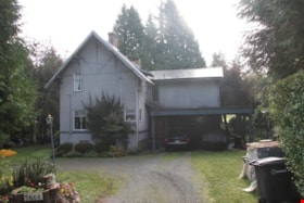
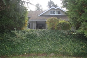
John Houston Residence
https://search.heritageburnaby.ca/link/landmark610
- Repository
- Burnaby Heritage Planning
- Description
- Residential building.
- Associated Dates
- c.1908
- Street View URL
- Google Maps Street View
- Repository
- Burnaby Heritage Planning
- Geographic Access
- Burris Street
- Associated Dates
- c.1908
- Description
- Residential building.
- Heritage Value
- The original resident of this house was John Houston, listed in the 1909 City Directory as a ‘rancher’, but is known as the long-time home of barrister Wrathman Sheridan Turner (1889-1974) and his wife Gertrude Helena (née Whealhouse) Turner. Stucco now covers the original exterior siding, though the house maintains its wide, overhanging eaves with exposed rafter tails and triangular eave brackets, indicative of the influence of the newly-emerging Arts and Crafts style.
- Locality
- Burnaby Lake
- Historic Neighbourhood
- Burnaby Lake (Historic Neighbourhood)
- Planning Study Area
- Morley-Buckingham Area
- Area
- 1312.47
- Contributing Resource
- Building
- Ownership
- Private
- Street Address
- 7668 Burris Street
- Street View URL
- Google Maps Street View
Images
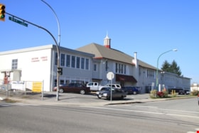
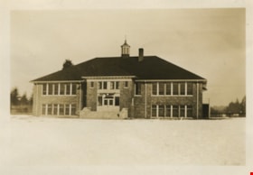
Second Street School
https://search.heritageburnaby.ca/link/landmark638
- Repository
- Burnaby Heritage Planning
- Description
- School building.
- Associated Dates
- 1928
- Street View URL
- Google Maps Street View
- Repository
- Burnaby Heritage Planning
- Geographic Access
- 2nd Street
- Associated Dates
- 1928
- Description
- School building.
- Heritage Value
- The Second Street School was originally established at this location as a two-room schoolhouse in 1913 to relieve the overcrowding of Edmonds School during the pre-First World War building boom. The old school was converted into an auditorium when this handsome school building was constructed in 1928. The new school, built by local contractors Ward-Leverington Ltd., included four classrooms, a library, a room for the principal, and a room for the teachers. The original brick façade has been retained although it has been painted; other intact original features include the bellcast octagonal roof ventilator and the protruding front entrance. The Burnaby School Board architect at this time was the talented firm of McCarter & Nairne, who also designed the Douglas Road School. John Y. McCarter (1886-1981) and George Nairne (1884-1953) formed their partnership in 1921 after serving overseas during the First World War. The partners began designing houses and small apartment buildings, and larger commissions soon followed, including Vancouver’s first skyscraper, the Marine Building (1928-30).
- Locality
- East Burnaby
- Historic Neighbourhood
- East Burnaby (Historic Neighbourhood)
- Planning Study Area
- Second Street Area
- Architect
- McCarter & Nairne
- Area
- 15777.66
- Contributing Resource
- Building
- Street Address
- 7502 2nd Street
- Street View URL
- Google Maps Street View
Images
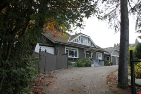
Stowe Residence
https://search.heritageburnaby.ca/link/landmark642
- Repository
- Burnaby Heritage Planning
- Description
- Residential building.
- Associated Dates
- 1930
- Street View URL
- Google Maps Street View
- Repository
- Burnaby Heritage Planning
- Geographic Access
- Burris Street
- Associated Dates
- 1930
- Description
- Residential building.
- Heritage Value
- This charming home was built for George Norman Stowe (1885-1955) and his wife Lillian (née Ross) Stowe after they purchased this property from the Municipality of Burnaby in a Depression-era tax sale. George Stowe was a civil engineer with the Provincial Department of Public Works from 1905 until 1950. Inspired by the British Arts and Crafts movement, this stuccoed cottage is notable for its picturesque side gabled roof with sloped eaves, and a jerkin-headed dormer with half-timbering. Multi-paned casement windows are used throughout the house, adding to the picturesque effect. A verandah with a colonnade of pillars on the east side of the home overlooks a ravine.
- Locality
- Burnaby Lake
- Historic Neighbourhood
- Burnaby Lake (Historic Neighbourhood)
- Planning Study Area
- Morley-Buckingham Area
- Area
- 1963.96
- Contributing Resource
- Building
- Ownership
- Private
- Street Address
- 7484 Burris Street
- Street View URL
- Google Maps Street View
Images
William & Annie Mawhinney Residence
https://search.heritageburnaby.ca/link/landmark654
- Repository
- Burnaby Heritage Planning
- Description
- Residential building.
- Associated Dates
- 1923
- Street View URL
- Google Maps Street View
- Repository
- Burnaby Heritage Planning
- Geographic Access
- Burris Street
- Associated Dates
- 1923
- Description
- Residential building.
- Heritage Value
- This bungalow was built by local farmer William Alexander Mawhinney (1870-1953) and Annie J. Mawhinney (1871-1956). This was one of several houses built in the immediate vicinity by members of the Mawhinney family between 1909 and 1930. William Mawhinney first came to Burnaby to help his brother Isaiah establish his fruit farm. In about 1930, William and Annie Mawhinney built a new house at 6011 Buckingham Avenue. This home is architecturally notable for its unusual front-gabled dormer, which is divided into parallel ridges at its peak. Though the original exterior wall siding has been covered by a later coat of stucco, it otherwise remains in largely original condition including double-hung windows with multi-paned upper sashes, front door with full-length sidelights and a decorative built-in window box.
- Locality
- Burnaby Lake
- Historic Neighbourhood
- Burnaby Lake (Historic Neighbourhood)
- Planning Study Area
- Morley-Buckingham Area
- Area
- 891.70
- Contributing Resource
- Building
- Ownership
- Private
- Street Address
- 7616 Burris Street
- Street View URL
- Google Maps Street View
Images
Landscape plan for front yard of Mawhinney house
https://search.heritageburnaby.ca/link/museumdescription15582
- Repository
- Burnaby Village Museum
- Date
- [between 1988 and 1990]
- Collection/Fonds
- Reverend Edward S. Gale fonds
- Description Level
- Item
- Physical Description
- 1 architectural drawing : pencil on parchment ; 30 x 56 cm
- Scope and Content
- Item consists of a landscape drawing identifying the layout and types of trees and bushes to be planted on the property of the Mervin Mawhinney house located at 7667 Burris Street in Burnaby while it was owned by Reverend Edward S. Gale. Grounds on the site were re-landscaped by Reverend Edward S. …
- Repository
- Burnaby Village Museum
- Collection/Fonds
- Reverend Edward S. Gale fonds
- Description Level
- Item
- Physical Description
- 1 architectural drawing : pencil on parchment ; 30 x 56 cm
- Scope and Content
- Item consists of a landscape drawing identifying the layout and types of trees and bushes to be planted on the property of the Mervin Mawhinney house located at 7667 Burris Street in Burnaby while it was owned by Reverend Edward S. Gale. Grounds on the site were re-landscaped by Reverend Edward S. Gale between 1988 and 1990..
- Geographic Access
- Burris Street
- Street Address
- 7667 Burris Street
- Accession Code
- BV018.9.48
- Access Restriction
- No restrictions
- Reproduction Restriction
- May be restricted by third party rights
- Date
- [between 1988 and 1990]
- Media Type
- Architectural Drawing
- Planning Study Area
- Morley-Buckingham Area
- Scan Resolution
- 600
- Scan Date
- May 3, 2021
- Scale
- 100
- Notes
- Title based on contents of photograph
Images
Landscape plan for front yard of Mawhinney house
https://search.heritageburnaby.ca/link/museumdescription15583
- Repository
- Burnaby Village Museum
- Date
- [between 1988 and 1990]
- Collection/Fonds
- Reverend Edward S. Gale fonds
- Description Level
- Item
- Physical Description
- 1 architectural drawing : blueline print with pencil ; 42.5 x 59.5 cm
- Scope and Content
- Item consists of an architectural landscape plan identifying the layout and types of trees and bushes to be planted in the front yard of the Mervin Mawhinney house located at 7667 Burris Street in Burnaby while it was owned by Reverend Edward S. Gale. Plantings identified include; Juniper, Rhodendr…
- Repository
- Burnaby Village Museum
- Collection/Fonds
- Reverend Edward S. Gale fonds
- Description Level
- Item
- Physical Description
- 1 architectural drawing : blueline print with pencil ; 42.5 x 59.5 cm
- Scope and Content
- Item consists of an architectural landscape plan identifying the layout and types of trees and bushes to be planted in the front yard of the Mervin Mawhinney house located at 7667 Burris Street in Burnaby while it was owned by Reverend Edward S. Gale. Plantings identified include; Juniper, Rhodendron, Azaleas, abelia, Rosh Rogos. Grounds on the site were re-landscaped by Reverend Edward S. Gale between 1988 and 1990.
- Geographic Access
- Burris Street
- Street Address
- 7667 Burris Street
- Accession Code
- BV018.9.49
- Access Restriction
- No restrictions
- Reproduction Restriction
- May be restricted by third party rights
- Date
- [between 1988 and 1990]
- Media Type
- Architectural Drawing
- Planning Study Area
- Morley-Buckingham Area
- Related Material
- See also BV018.9.30
- Scan Resolution
- 600
- Scan Date
- May 3, 2021
- Scale
- 100
- Notes
- Title based on contents of photograph
![Landscape plan for front yard of Mawhinney house, [between 1988 and 1990] thumbnail](/media/hpo/_Data/_BVM_Architectural_Drawings/2018_0009_0048_001.jpg?width=280)
![Landscape plan for front yard of Mawhinney house, [between 1988 and 1990] thumbnail](/media/hpo/_Data/_BVM_Architectural_Drawings/2018_0009_0049_001.jpg?width=280)