Narrow Results By
Subject
- Accidents - Train Accidents
- Construction - Railroad Construction 3
- First Nations reserves - British Columbia 1
- Geographic Features - Roads 2
- Indigenous peoples - Indian Territory
- Occupations - Engineers 1
- Occupations - Railroad Labourers 2
- Transportation - Electric Railroads 1
- Transportation - Locomotives 6
- Transportation - Rail 17
Person / Organization
- Burnaby Village Museum 1
- Canadian National Railway 4
- Canadian Pacific Railway Company 2
- Farmer, Joanne 6
- Great Northern Railway
- Hardman, Jack 1
- Hawkshaw, Richard Crichton Gilliland "Crichton" 1
- Hill, Louis Claude "Claude" 1
- ʷməθkʷəy̓əm (Musqueam) 4
- Preissl, Nicole 1
- Sḵwx̱wú7mesh Nation 1
- Thomas, Carleen 1
![Survey and Subdivision plans in New Westminster District Group 2 - Surrey and Map of Surrey Municipality, [190-] thumbnail](/media/hpo/_Data/_BVM_Cartographic_Material/1977/1977_0093_0094_003.jpg?width=280)
Survey and Subdivision plans in New Westminster District Group 2 - Surrey and Map of Surrey Municipality
https://search.heritageburnaby.ca/link/museumdescription7063
- Repository
- Burnaby Village Museum
- Date
- [190-]
- Collection/Fonds
- Burnaby Village Museum Map collection
- Description Level
- File
- Physical Description
- 5 plans : blueprints on paper ; various sizes mounted on 2 sides of cardboard 76 x 102 cm
- Scope and Content
- File consists of a large board with two plans in New Westminster District (Group 2) mounted on one side and three plans in New Westminster District (Group 2) mounted on the other side. Side A: 1. Plan : blueprint on paper ; 75.5 x 64.5 cm. Title reads: "South Westminster / Plan/ of Subdivision of…
- Repository
- Burnaby Village Museum
- Collection/Fonds
- Burnaby Village Museum Map collection
- Description Level
- File
- Physical Description
- 5 plans : blueprints on paper ; various sizes mounted on 2 sides of cardboard 76 x 102 cm
- Material Details
- Scales vary (One chain equals 792 inches)
- Indexed number on tape on edge of board reads 94"
- Scope and Content
- File consists of a large board with two plans in New Westminster District (Group 2) mounted on one side and three plans in New Westminster District (Group 2) mounted on the other side. Side A: 1. Plan : blueprint on paper ; 75.5 x 64.5 cm. Title reads: "South Westminster / Plan/ of Subdivision of / Lot 440, G2, E1/2Sec36, NE1/4Sec25, N1/2ofSE1/4Sec25, T4.NW1/4S31,T2.". Subdivision plan covers subdivided property in Lot 440 and Section 36, Section 25 in New Westminster, Group 2, Township 4 (Delta) and Section 31 in Township 2 (Surrey). Includes inset map noting property in "South Westminster". Map is bordered by Burrard Inlet to the north and Mud Bay to the south. (Geographic locations: North Delta and Surrey) 2. Plan : blueprint on paper ; 22.5 x 59.5 cm. Title reads: "Plan / Shewing part of / Section 10 Block 5 North R.I.W. / New Westminster District / Lying North of B.C.S.Railway". Scale: 2 chains = 1 inch. Signed by A.S. Colton, District Land Surveyor. March 1, 1900. Plan covers property in Section 10, Block 5 North in New Westminster District, Group 2, along the south shore of the Fraser River with the Great Northern Railway running through. (Geographic location: Surrey) Side B: 1. Map : blueprint on paper ; 69 x 53 cm. Title reads: "Map / of / Surrey Municipality". Scale: 5 chains = 1 inch. Creator and surveyor of map is identified as "Albert J. Hill, M.A., Civil Engineer / And / Provincial Land Surveyor, / New Westminster, / B.C.". Map identifies property divisions including lots with names of property owners, Sections, Townships, Wards, waterways, major roads, railways and the Semiahmoo Indian Reserve on the shore of "Semiahmoo Bay" and an indian reserve (I.R.) located in Lot 1 along the south shore of the Fraser River. 2. Plan : blueprint on paper ; 21 x 40.5 cm. Title reads: "Plan / of / Sudivision of / Section 32, / Block 5 North Range 1 West, / District of New Westminster, B.C.". Scale: 4 chains = 1 inch. Sudivision plan is signed by Albert J. Hill, B.C. Land Surveyor. Plan covers Section 32, subdivided into 28 parcels. Section 32 is bordered by Section 29 (north), Section 33, Johnston Road (east), Section 34, Township 2, Town Line Road (south) and Section 31 (west). (Geographic location: Surrey) 3. Plan : blueprint on paper ; 49.5 x 37 cm. Title reads: "Traverse of the Waterline / in front of / Lots 3 and 4 Group 2 / N.W.D. / with G.N. Railway Rt of Way". Scale: 100 feet = 1 inch. Annotation on board below plan reads: "also see Boards 87 & 93 & 110". Location south of the Fraser River with old wharf identified and Great Northern Railway running east to west along the river. (Geographic location: Surrey)
- Names
- Great Northern Railway
- Accession Code
- HV977.93.94
- Access Restriction
- No restrictions
- Reproduction Restriction
- No known restrictions
- Date
- [190-]
- Media Type
- Cartographic Material
- Scan Resolution
- 600
- Scan Date
- 2023-06-26
- Notes
- Title based on contents of file
Zoomable Images
![Survey and Subdivision plans in New Westminster District Group 2 - Surrey and Map of Surrey Municipality, [190-] thumbnail](/media/hpo/_Data/_BVM_Cartographic_Material/1977/1977_0093_0094_003_seadragon/1977_0093_0094_003.jpg?w=280)
Survey and Subdivision plans in New Westminster District Group 2 - Surrey and Map of Surrey Municipality, [190-]
Zoom into Image
Train wreck
https://search.heritageburnaby.ca/link/archivedescription74184
- Repository
- City of Burnaby Archives
- Date
- July 1941
- Collection/Fonds
- Gordon McDonald collection
- Description Level
- Item
- Physical Description
- 1 photograph : b&w ; 8 x 11.5 cm
- Scope and Content
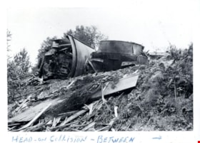
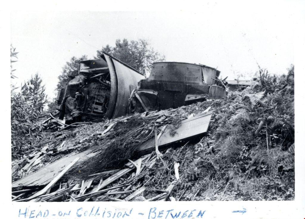
- Photograph of the aftermath of a train wreck that took place in the North Road cut due to a head-on collision between Canadian National Railway (CNR) and Great Northern Railway (GNR) trains.
- Repository
- City of Burnaby Archives
- Date
- July 1941
- Collection/Fonds
- Gordon McDonald collection
- Physical Description
- 1 photograph : b&w ; 8 x 11.5 cm
- Description Level
- Item
- Record No.
- 542-001
- Access Restriction
- No restrictions
- Reproduction Restriction
- No known restrictions
- Accession Number
- 2012-23
- Scope and Content
- Photograph of the aftermath of a train wreck that took place in the North Road cut due to a head-on collision between Canadian National Railway (CNR) and Great Northern Railway (GNR) trains.
- Subjects
- Accidents - Train Accidents
- Media Type
- Photograph
- Notes
- Title based on contents of photograph
- Note in pen on border (recto) of photograph reads: "Head-On Collision - Between - "
Images
Train wreck
https://search.heritageburnaby.ca/link/archivedescription74185
- Repository
- City of Burnaby Archives
- Date
- July 1941
- Collection/Fonds
- Gordon McDonald collection
- Description Level
- Item
- Physical Description
- 1 photograph : b&w ; 8 x 11.5 cm
- Scope and Content
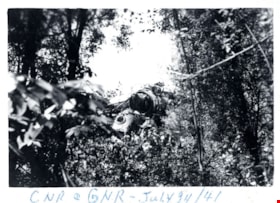
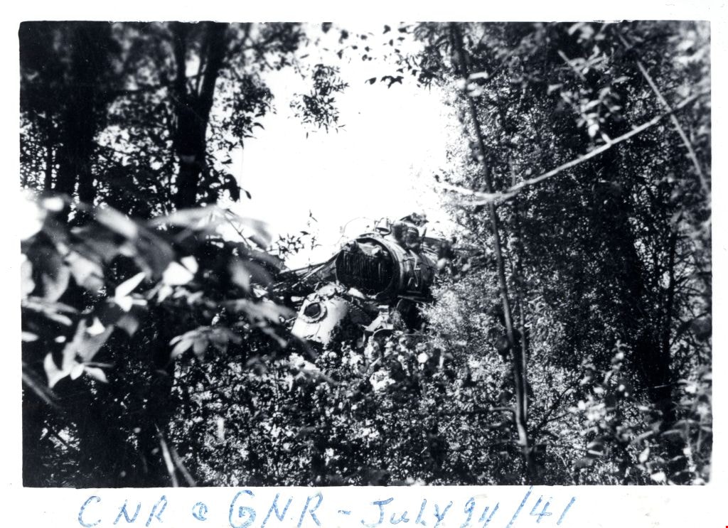
- Photograph of the aftermath of a train wreck that took place in the North Road cut due to a head-on collision between Canadian National Railway (CNR) and Great Northern Railway (GNR) trains.
- Repository
- City of Burnaby Archives
- Date
- July 1941
- Collection/Fonds
- Gordon McDonald collection
- Physical Description
- 1 photograph : b&w ; 8 x 11.5 cm
- Description Level
- Item
- Record No.
- 542-002
- Access Restriction
- No restrictions
- Reproduction Restriction
- No known restrictions
- Accession Number
- 2012-23
- Scope and Content
- Photograph of the aftermath of a train wreck that took place in the North Road cut due to a head-on collision between Canadian National Railway (CNR) and Great Northern Railway (GNR) trains.
- Subjects
- Accidents - Train Accidents
- Media Type
- Photograph
- Notes
- Title based on contents of photograph
- Note in pen on border (recto) of photograph reads: "CNR + GNR - July [?]4, 41"
Images
Train wreck
https://search.heritageburnaby.ca/link/archivedescription74186
- Repository
- City of Burnaby Archives
- Date
- July 1941
- Collection/Fonds
- Gordon McDonald collection
- Description Level
- Item
- Physical Description
- 1 photograph : b&w ; 8 x 11.5 cm
- Scope and Content
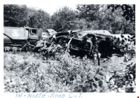
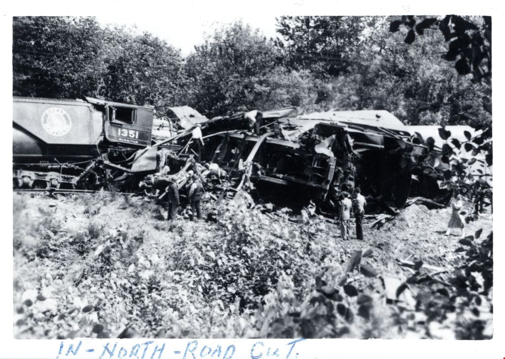
- Photograph of a group of people viewing the aftermath of a train wreck that took place in the North Road cut due to a head-on collision between Canadian National Railway (CNR) and Great Northern Railway (GNR) trains.
- Repository
- City of Burnaby Archives
- Date
- July 1941
- Collection/Fonds
- Gordon McDonald collection
- Physical Description
- 1 photograph : b&w ; 8 x 11.5 cm
- Description Level
- Item
- Record No.
- 542-003
- Access Restriction
- No restrictions
- Reproduction Restriction
- No known restrictions
- Accession Number
- 2012-23
- Scope and Content
- Photograph of a group of people viewing the aftermath of a train wreck that took place in the North Road cut due to a head-on collision between Canadian National Railway (CNR) and Great Northern Railway (GNR) trains.
- Subjects
- Accidents - Train Accidents
- Media Type
- Photograph
- Notes
- Title based on contents of photograph
- Note in pen on border (recto) of photograph reads: "In - North - Road Cut."
Images
Train wreck
https://search.heritageburnaby.ca/link/archivedescription74187
- Repository
- City of Burnaby Archives
- Date
- July 1941
- Collection/Fonds
- Gordon McDonald collection
- Description Level
- Item
- Physical Description
- 1 photograph : b&w ; 8 x 11.5 cm
- Scope and Content
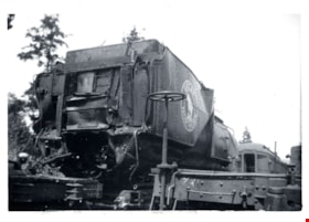
- Photograph of a Great Northern Railway train-car damaged from a train wreck that took place in the North Road cut. This was a head-on collision between Canadian National Railway (CNR) and Great Northern Railway (GNR) trains.
- Repository
- City of Burnaby Archives
- Date
- July 1941
- Collection/Fonds
- Gordon McDonald collection
- Physical Description
- 1 photograph : b&w ; 8 x 11.5 cm
- Description Level
- Item
- Record No.
- 542-004
- Access Restriction
- No restrictions
- Reproduction Restriction
- No known restrictions
- Accession Number
- 2012-23
- Scope and Content
- Photograph of a Great Northern Railway train-car damaged from a train wreck that took place in the North Road cut. This was a head-on collision between Canadian National Railway (CNR) and Great Northern Railway (GNR) trains.
- Subjects
- Accidents - Train Accidents
- Media Type
- Photograph
- Notes
- Title based on contents of photograph
Images

![Wrecked rail cars, [May 1913] thumbnail](/media/hpo/_Data/_BVM_Images/1977/197900540001.jpg?width=280)
Wrecked rail cars
https://search.heritageburnaby.ca/link/museumdescription1429
- Repository
- Burnaby Village Museum
- Date
- [May 1913]
- Collection/Fonds
- Burnaby Village Museum Photograph collection
- Description Level
- Item
- Physical Description
- 1 photograph : b&w ; 8.1 x 13.9 cm
- Scope and Content
- Photograph of several wrecked rail cars abandoned on the side of a railway. There is gravel, rocks and dirt in the foreground, beside the railway tracks and a forested area in the background. An annotation on the back of the photograph reads: "Wrecked cares - Dump #4 / G.N. reclamation work / Vanco…
- Repository
- Burnaby Village Museum
- Collection/Fonds
- Burnaby Village Museum Photograph collection
- Description Level
- Item
- Physical Description
- 1 photograph : b&w ; 8.1 x 13.9 cm
- Scope and Content
- Photograph of several wrecked rail cars abandoned on the side of a railway. There is gravel, rocks and dirt in the foreground, beside the railway tracks and a forested area in the background. An annotation on the back of the photograph reads: "Wrecked cares - Dump #4 / G.N. reclamation work / Vancouver, B.C. / May - 1913." The accession register speculates that the photograph may be of an accident on the Great Northern line at Sperling.
- Names
- Great Northern Railway
- Geographic Access
- Vancouver
- Accession Code
- HV979.54.1
- Access Restriction
- No restrictions
- Reproduction Restriction
- No known restrictions
- Date
- [May 1913]
- Media Type
- Photograph
- Scan Resolution
- 600
- Scan Date
- 2023-09-12
- Notes
- Title based on contents of photograph
Images
![Wrecked rail cars, [May 1913] thumbnail](/media/hpo/_Data/_BVM_Images/1977/197900540001.jpg)