More like 'postcard'
Narrow Results By
Subject
- Accidents - Automobile Accidents 1
- Advertising Medium 3
- Advertising Medium - Signs and Signboards 82
- Aerial Photographs 127
- Agricultural Tools and Equipment - Plows 3
- Agriculture 2
- Agriculture - Crops 4
- Agriculture - Farms 48
- Agriculture - Fruit and Berries 7
- Agriculture - Poultry 4
- Animals - Birds 2
- Animals - Cats 5
![Sambo's Pancake House, [196-] thumbnail](/media/hpo/_Data/_Archives_Images/_Unrestricted/126/201-001.jpg?width=280)
Sambo's Pancake House
https://search.heritageburnaby.ca/link/archivedescription35138
- Repository
- City of Burnaby Archives
- Date
- [196-]
- Collection/Fonds
- Burnaby Historical Society fonds
- Description Level
- Item
- Physical Description
- 1 photograph : col. postcard ; 8.9 x 14.0 cm
- Scope and Content
- Photographic postcard of the exterior and parking lot of Sambo's Pancake House, Kingsway. Printed on the top of the front of the postcard is "Sambo's Pancake House," and a sign on the building read's "Sambo's." Written on the back of the postcard: "Please surrender this card for 10% discount on you…
- Repository
- City of Burnaby Archives
- Date
- [196-]
- Collection/Fonds
- Burnaby Historical Society fonds
- Subseries
- Photographs subseries
- Physical Description
- 1 photograph : col. postcard ; 8.9 x 14.0 cm
- Description Level
- Item
- Record No.
- 201-001
- Access Restriction
- No restrictions
- Reproduction Restriction
- Reproduce for fair dealing purposes only
- Accession Number
- BHS1987-10
- Scope and Content
- Photographic postcard of the exterior and parking lot of Sambo's Pancake House, Kingsway. Printed on the top of the front of the postcard is "Sambo's Pancake House," and a sign on the building read's "Sambo's." Written on the back of the postcard: "Please surrender this card for 10% discount on your next visit to Sambo's, 5550 Kingsway, Burnaby. Offer good until Feb. 28th, 1969. Your host Sambo's."
- Subjects
- Geographic Features - Automobile Parking Lots
- Documentary Artifacts - Postcards
- Buildings - Commercial - Restaurants
- Names
- Sambo's Pancake House
- Media Type
- Photograph
- Notes
- Title based on contents of photograph
- Geographic Access
- Kingsway
- Street Address
- 5550 Kingsway
- Historic Neighbourhood
- Central Park (Historic Neighbourhood)
- Planning Study Area
- Windsor Area
Images
![Sambo's Pancake House, [196-] thumbnail](/media/hpo/_Data/_Archives_Images/_Unrestricted/126/201-001.jpg)
![The Sorting Table, [191-] thumbnail](/media/hpo/_Data/_Archives_Images/_Unrestricted/540/540-009.jpg?width=280)
The Sorting Table
https://search.heritageburnaby.ca/link/archivedescription73601
- Repository
- City of Burnaby Archives
- Date
- [191-]
- Collection/Fonds
- LaFavor Family fonds
- Description Level
- Item
- Physical Description
- 1 photograph : sepia postcard ; 8.5 x 14 cm
- Scope and Content
- Photographic postcard of the sorting table at the North Pacific Lumber Company in Barnet Village, BC.
- Repository
- City of Burnaby Archives
- Date
- [191-]
- Collection/Fonds
- LaFavor Family fonds
- Physical Description
- 1 photograph : sepia postcard ; 8.5 x 14 cm
- Description Level
- Item
- Record No.
- 540-009
- Access Restriction
- No restrictions
- Reproduction Restriction
- No restrictions
- Accession Number
- 2007-03
- Scope and Content
- Photographic postcard of the sorting table at the North Pacific Lumber Company in Barnet Village, BC.
- Subjects
- Documentary Artifacts - Postcards
- Industries - Logging/lumber
- Industries - Forestry
- Buildings - Industrial - Mills
- Names
- Barnet Mill
- Media Type
- Photograph
- Photographer
- Canadian Photo Company
- Notes
- Transcribed title
- Geographic Access
- Barnet Village
- Texaco Drive
- Street Address
- 8059 Texaco Drive
- Historic Neighbourhood
- Barnet (Historic Neighbourhood)
- Planning Study Area
- Burnaby Mountain Area
Images
![The Sorting Table, [191-] thumbnail](/media/hpo/_Data/_Archives_Images/_Unrestricted/540/540-009.jpg)
![St. Alban's Anglican Church, [1909] (date of original), copied 1986 thumbnail](/media/hpo/_Data/_Archives_Images/_Unrestricted/126/171-024.jpg?width=280)
St. Alban's Anglican Church
https://search.heritageburnaby.ca/link/archivedescription35003
- Repository
- City of Burnaby Archives
- Date
- [1909] (date of original), copied 1986
- Collection/Fonds
- Burnaby Historical Society fonds
- Description Level
- Item
- Physical Description
- 1 photograph : b&w postcard ; 8.5 x 11.8 cm
- Scope and Content
- Photograph on a postcard of the exterior of St. Alban's Anglican Church at 7717 19th Avenue, near Douglas Road (now Canada Way) and Edmonds Street.
- Repository
- City of Burnaby Archives
- Date
- [1909] (date of original), copied 1986
- Collection/Fonds
- Burnaby Historical Society fonds
- Subseries
- Patterson family subseries
- Physical Description
- 1 photograph : b&w postcard ; 8.5 x 11.8 cm
- Description Level
- Item
- Record No.
- 171-024
- Access Restriction
- No restrictions
- Reproduction Restriction
- No known restrictions
- Accession Number
- BHS1986-20
- Scope and Content
- Photograph on a postcard of the exterior of St. Alban's Anglican Church at 7717 19th Avenue, near Douglas Road (now Canada Way) and Edmonds Street.
- Media Type
- Photograph
- Notes
- Title based on contents of photograph
- Geographic Access
- 19th Avenue
- Street Address
- 7717 19th Avenue
- Historic Neighbourhood
- Edmonds (Historic Neighbourhood)
- Planning Study Area
- Edmonds Area
Images
![St. Alban's Anglican Church, [1909] (date of original), copied 1986 thumbnail](/media/hpo/_Data/_Archives_Images/_Unrestricted/126/171-024.jpg)
![St. Albans the Martyr Church, [1912] thumbnail](/media/hpo/_Data/_Archives_Images/_Unrestricted/371/449-012.jpg?width=280)
St. Albans the Martyr Church
https://search.heritageburnaby.ca/link/archivedescription38517
- Repository
- City of Burnaby Archives
- Date
- [1912]
- Collection/Fonds
- Burnaby Historical Society fonds
- Description Level
- Item
- Physical Description
- 1 photograph : b&w postcard ; 8.5 x 14 cm
- Scope and Content
- Photographic postcard of the St. Albans the Martyr Church at Canada Way and 19th Avenue.
- Repository
- City of Burnaby Archives
- Date
- [1912]
- Collection/Fonds
- Burnaby Historical Society fonds
- Subseries
- Photographs subseries
- Physical Description
- 1 photograph : b&w postcard ; 8.5 x 14 cm
- Description Level
- Item
- Record No.
- 449-012
- Access Restriction
- No restrictions
- Reproduction Restriction
- No known restrictions
- Accession Number
- BHS2007-04
- Scope and Content
- Photographic postcard of the St. Albans the Martyr Church at Canada Way and 19th Avenue.
- Media Type
- Photograph
- Notes
- Title based on contents of photograph
- Geographic Access
- Canada Way
- 19th Avenue
- Street Address
- 7717 19th Avenue
- Historic Neighbourhood
- Edmonds (Historic Neighbourhood)
- Planning Study Area
- Edmonds Area
Images
![St. Albans the Martyr Church, [1912] thumbnail](/media/hpo/_Data/_Archives_Images/_Unrestricted/371/449-012.jpg)
![Steady Work and Keep, [191-] thumbnail](/media/hpo/_Data/_Archives_Images/_Unrestricted/540/540-029.jpg?width=280)
Steady Work and Keep
https://search.heritageburnaby.ca/link/archivedescription73621
- Repository
- City of Burnaby Archives
- Date
- [191-]
- Collection/Fonds
- LaFavor Family fonds
- Description Level
- Item
- Physical Description
- 1 photograph : sepia postcard ; 8.2 x 13.5 cm
- Scope and Content
- Photographic postcard of the mill in Barnet Village, BC. The image is captioned "Steady work and Keep, Barnet, BC." The Barnet Mill was called the North Pacific Lumber Company from 1889 to 1914.
- Repository
- City of Burnaby Archives
- Date
- [191-]
- Collection/Fonds
- LaFavor Family fonds
- Physical Description
- 1 photograph : sepia postcard ; 8.2 x 13.5 cm
- Description Level
- Item
- Record No.
- 540-029
- Access Restriction
- No restrictions
- Reproduction Restriction
- No restrictions
- Accession Number
- 2007-03
- Scope and Content
- Photographic postcard of the mill in Barnet Village, BC. The image is captioned "Steady work and Keep, Barnet, BC." The Barnet Mill was called the North Pacific Lumber Company from 1889 to 1914.
- Subjects
- Documentary Artifacts - Postcards
- Industries - Forestry
- Buildings - Industrial - Mills
- Animals - Horses
- Transportation - Carts
- Names
- Barnet Mill
- Media Type
- Photograph
- Photographer
- Timms Photographic Co.
- Notes
- Transcribed title
- Geographic Access
- Barnet Village
- Texaco Drive
- Historic Neighbourhood
- Barnet (Historic Neighbourhood)
- Planning Study Area
- Burnaby Mountain Area
Images
![Steady Work and Keep, [191-] thumbnail](/media/hpo/_Data/_Archives_Images/_Unrestricted/540/540-029.jpg)
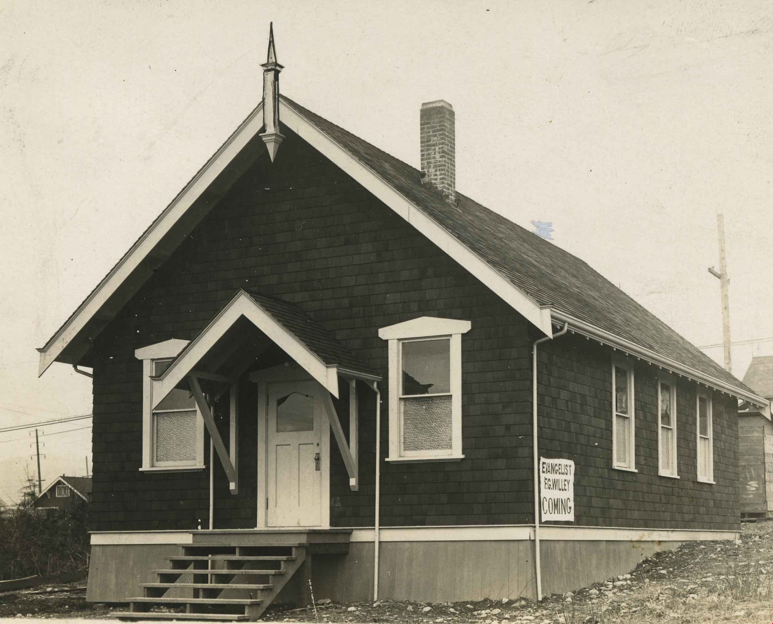
![St. John the Divine Church, [191-] thumbnail](/media/hpo/_Data/_Archives_Images/_Unrestricted/371/449-011.jpg?width=280)
St. John the Divine Church
https://search.heritageburnaby.ca/link/archivedescription38516
- Repository
- City of Burnaby Archives
- Date
- [191-]
- Collection/Fonds
- Burnaby Historical Society fonds
- Description Level
- Item
- Physical Description
- 1 photograph : b&w postcard ; 8.5 x 14 cm
- Scope and Content
- Photographic postcard of St. John the Divine church at Kingsway and Central Park.
- Repository
- City of Burnaby Archives
- Date
- [191-]
- Collection/Fonds
- Burnaby Historical Society fonds
- Subseries
- Photographs subseries
- Physical Description
- 1 photograph : b&w postcard ; 8.5 x 14 cm
- Description Level
- Item
- Record No.
- 449-011
- Access Restriction
- No restrictions
- Reproduction Restriction
- No restrictions
- Accession Number
- BHS2007-04
- Scope and Content
- Photographic postcard of St. John the Divine church at Kingsway and Central Park.
- Media Type
- Photograph
- Notes
- Title based on contents of photograph
- Geographic Access
- Central Park
- Kingsway
- Street Address
- 3891 Kingsway
- Historic Neighbourhood
- Central Park (Historic Neighbourhood)
- Planning Study Area
- Garden Village Area
Images
![St. John the Divine Church, [191-] thumbnail](/media/hpo/_Data/_Archives_Images/_Unrestricted/371/449-011.jpg)
![Stock Sheds, [191-] thumbnail](/media/hpo/_Data/_Archives_Images/_Unrestricted/540/540-013.jpg?width=280)
Stock Sheds
https://search.heritageburnaby.ca/link/archivedescription73605
- Repository
- City of Burnaby Archives
- Date
- [191-]
- Collection/Fonds
- LaFavor Family fonds
- Description Level
- Item
- Physical Description
- 1 photograph : sepia postcard ; 8.5 x 14 cm
- Scope and Content
- Photographic postcard of the exterior of the stock sheds at the North Pacific Lumber Company in Barnet Village, BC.
- Repository
- City of Burnaby Archives
- Date
- [191-]
- Collection/Fonds
- LaFavor Family fonds
- Physical Description
- 1 photograph : sepia postcard ; 8.5 x 14 cm
- Description Level
- Item
- Record No.
- 540-013
- Access Restriction
- No restrictions
- Reproduction Restriction
- No restrictions
- Accession Number
- 2007-03
- Scope and Content
- Photographic postcard of the exterior of the stock sheds at the North Pacific Lumber Company in Barnet Village, BC.
- Subjects
- Documentary Artifacts - Postcards
- Industries - Logging/lumber
- Industries - Forestry
- Buildings - Industrial - Mills
- Names
- Barnet Mill
- Media Type
- Photograph
- Photographer
- Canadian Photo Company
- Notes
- Transcribed title
- Geographic Access
- Barnet Village
- Texaco Drive
- Street Address
- 8059 Texaco Drive
- Historic Neighbourhood
- Barnet (Historic Neighbourhood)
- Planning Study Area
- Burnaby Mountain Area
Images
![Stock Sheds, [191-] thumbnail](/media/hpo/_Data/_Archives_Images/_Unrestricted/540/540-013.jpg)
![Stockyards from West, [191-] thumbnail](/media/hpo/_Data/_Archives_Images/_Unrestricted/540/540-021.jpg?width=280)
Stockyards from West
https://search.heritageburnaby.ca/link/archivedescription73613
- Repository
- City of Burnaby Archives
- Date
- [191-]
- Collection/Fonds
- LaFavor Family fonds
- Description Level
- Item
- Physical Description
- 1 photograph : sepia postcard ; 8.5 x 14 cm
- Scope and Content
- Photographic postcard of the stockyards at the North Pacific Lumber Company located in Barnet, BC. The photograph is taken from the west.
- Repository
- City of Burnaby Archives
- Date
- [191-]
- Collection/Fonds
- LaFavor Family fonds
- Physical Description
- 1 photograph : sepia postcard ; 8.5 x 14 cm
- Description Level
- Item
- Record No.
- 540-021
- Access Restriction
- No restrictions
- Reproduction Restriction
- No restrictions
- Accession Number
- 2007-03
- Scope and Content
- Photographic postcard of the stockyards at the North Pacific Lumber Company located in Barnet, BC. The photograph is taken from the west.
- Subjects
- Documentary Artifacts - Postcards
- Industries - Logging/lumber
- Industries - Forestry
- Buildings - Industrial - Mills
- Names
- Barnet Mill
- Media Type
- Photograph
- Photographer
- Canadian Photo Company
- Notes
- Transcribed title
- Geographic Access
- Barnet Village
- Texaco Drive
- Street Address
- 8059 Texaco Drive
- Historic Neighbourhood
- Barnet (Historic Neighbourhood)
- Planning Study Area
- Burnaby Mountain Area
Images
![Stockyards from West, [191-] thumbnail](/media/hpo/_Data/_Archives_Images/_Unrestricted/540/540-021.jpg)
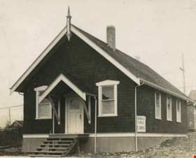
Tabernacle Church
https://search.heritageburnaby.ca/link/archivedescription38676
- Repository
- City of Burnaby Archives
- Date
- 1930
- Collection/Fonds
- Burnaby Historical Society fonds
- Description Level
- Item
- Physical Description
- 1 photograph : b&w postcard ; 9 x 10.8 cm
- Scope and Content
- Photographic postcard of the Union Tabernacle Church at 3891 Georgia Street.
- Repository
- City of Burnaby Archives
- Date
- 1930
- Collection/Fonds
- Burnaby Historical Society fonds
- Subseries
- North Burnaby Board of Trade subseries
- Physical Description
- 1 photograph : b&w postcard ; 9 x 10.8 cm
- Description Level
- Item
- Record No.
- 476-019
- Access Restriction
- No restrictions
- Reproduction Restriction
- No known restrictions
- Accession Number
- BHS2005-8
- Scope and Content
- Photographic postcard of the Union Tabernacle Church at 3891 Georgia Street.
- Names
- Grace Tabernacle Church
- Media Type
- Photograph
- Notes
- Title based on contents of photograph.
- Geographic Access
- Georgia Street
- Historic Neighbourhood
- Vancouver Heights (Historic Neighbourhood)
- Planning Study Area
- Willingdon Heights Area
Images
![Trimmer Saws, [191-] thumbnail](/media/hpo/_Data/_Archives_Images/_Unrestricted/540/540-020.jpg?width=280)
Trimmer Saws
https://search.heritageburnaby.ca/link/archivedescription73612
- Repository
- City of Burnaby Archives
- Date
- [191-]
- Collection/Fonds
- LaFavor Family fonds
- Description Level
- Item
- Physical Description
- 1 photograph : sepia postcard ; 8.5 x 14 cm
- Scope and Content
- Photographic postcard of the trimmer saws used at the North Pacific Lumber Company located in Barnet, BC.
- Repository
- City of Burnaby Archives
- Date
- [191-]
- Collection/Fonds
- LaFavor Family fonds
- Physical Description
- 1 photograph : sepia postcard ; 8.5 x 14 cm
- Description Level
- Item
- Record No.
- 540-020
- Access Restriction
- No restrictions
- Reproduction Restriction
- No restrictions
- Accession Number
- 2007-03
- Scope and Content
- Photographic postcard of the trimmer saws used at the North Pacific Lumber Company located in Barnet, BC.
- Subjects
- Documentary Artifacts - Postcards
- Industries - Logging/lumber
- Industries - Forestry
- Buildings - Industrial - Mills
- Names
- Barnet Mill
- Media Type
- Photograph
- Photographer
- Canadian Photo Company
- Notes
- Transcribed title
- Geographic Access
- Barnet Village
- Texaco Drive
- Street Address
- 8059 Texaco Drive
- Historic Neighbourhood
- Barnet (Historic Neighbourhood)
- Planning Study Area
- Burnaby Mountain Area
Images
![Trimmer Saws, [191-] thumbnail](/media/hpo/_Data/_Archives_Images/_Unrestricted/540/540-020.jpg)
![West Burnaby School BC, [1910] thumbnail](/media/hpo/_Data/_Archives_Images/_Unrestricted/126/137-002.jpg?width=280)
West Burnaby School BC
https://search.heritageburnaby.ca/link/archivedescription34809
- Repository
- City of Burnaby Archives
- Date
- [1910]
- Collection/Fonds
- Burnaby Historical Society fonds
- Description Level
- Item
- Physical Description
- 1 photograph : sepia postcard ; 7.5 x 13 cm
- Scope and Content
- Photographic postcard of West Burnaby School (later renamed Kingsway West School). The sign on building on the right reads, "Gymnasium & Technical School."
- Repository
- City of Burnaby Archives
- Date
- [1910]
- Collection/Fonds
- Burnaby Historical Society fonds
- Subseries
- Grace Pletcher subseries
- Physical Description
- 1 photograph : sepia postcard ; 7.5 x 13 cm
- Description Level
- Item
- Record No.
- 137-002
- Access Restriction
- No restrictions
- Reproduction Restriction
- No known restrictions
- Accession Number
- BHS1985-06
- Scope and Content
- Photographic postcard of West Burnaby School (later renamed Kingsway West School). The sign on building on the right reads, "Gymnasium & Technical School."
- Names
- Kingsway West School
- Media Type
- Photograph
- Photographer
- Barrowclough, G.A.
- Notes
- Title taken from photographer's title
- Photographer's title reads: "West Burnaby School, BC / Barrowclough Cards"
- Geographic Access
- Kingsway
- Street Address
- 4800 Kingsway
- Historic Neighbourhood
- Central Park (Historic Neighbourhood)
- Planning Study Area
- Maywood Area
Images
![West Burnaby School BC, [1910] thumbnail](/media/hpo/_Data/_Archives_Images/_Unrestricted/126/137-002.jpg)

5130 Irving Street
https://search.heritageburnaby.ca/link/archivedescription98671
- Repository
- City of Burnaby Archives
- Date
- 2022
- Collection/Fonds
- Disappearing Burnaby collection
- Description Level
- Item
- Physical Description
- 1 photograph (jpeg) : col.
- Scope and Content
- Photograph of the front steps and the entrance of a three-storey apartment building located at 5130 Irving Street. The photograph depicts the building at night, with the lobby and some of the apartments' windows illuminated from inside. The building was constructed in 1971.
- Repository
- City of Burnaby Archives
- Date
- 2022
- Collection/Fonds
- Disappearing Burnaby collection
- Physical Description
- 1 photograph (jpeg) : col.
- Description Level
- Item
- Record No.
- 634-018
- Access Restriction
- No restrictions
- Reproduction Restriction
- No restrictions
- Accession Number
- 2022-14
- Scope and Content
- Photograph of the front steps and the entrance of a three-storey apartment building located at 5130 Irving Street. The photograph depicts the building at night, with the lobby and some of the apartments' windows illuminated from inside. The building was constructed in 1971.
- Media Type
- Photograph
- Photographer
- Cheung, Nakita
- Notes
- Title taken from the associated blog post
- Associated blog post: https://disappearingburnaby.wordpress.com/2022/05/04/e-just-e/
- Geographic Access
- Irving Street
- Street Address
- 5130 Irving Street
- Historic Neighbourhood
- Central Park (Historic Neighbourhood)
- Planning Study Area
- Marlborough Area
Images


5130 Irving Street lobby
https://search.heritageburnaby.ca/link/archivedescription98672
- Repository
- City of Burnaby Archives
- Date
- 2022
- Collection/Fonds
- Disappearing Burnaby collection
- Description Level
- Item
- Physical Description
- 1 photograph (jpeg) : col.
- Scope and Content
- Photograph of the entrance of an apartment building located at 5130 Irving Street. The building was constructed in 1971. The photograph depicts the entrance and the lobby from the exterior at night. The lobby is illuminated and a crest featuring an "E" is on the entrance window.
- Repository
- City of Burnaby Archives
- Date
- 2022
- Collection/Fonds
- Disappearing Burnaby collection
- Physical Description
- 1 photograph (jpeg) : col.
- Description Level
- Item
- Record No.
- 634-019
- Access Restriction
- No restrictions
- Reproduction Restriction
- No restrictions
- Accession Number
- 2022-14
- Scope and Content
- Photograph of the entrance of an apartment building located at 5130 Irving Street. The building was constructed in 1971. The photograph depicts the entrance and the lobby from the exterior at night. The lobby is illuminated and a crest featuring an "E" is on the entrance window.
- Media Type
- Photograph
- Photographer
- Cheung, Nakita
- Notes
- Title taken from the associated blog post
- Associated blog post: https://disappearingburnaby.wordpress.com/2022/05/04/e-just-e/
- Geographic Access
- Irving Street
- Street Address
- 5130 Irving Street
- Historic Neighbourhood
- Central Park (Historic Neighbourhood)
- Planning Study Area
- Marlborough Area
Images


6280 Marlborough Avenue
https://search.heritageburnaby.ca/link/archivedescription98673
- Repository
- City of Burnaby Archives
- Date
- 2022
- Collection/Fonds
- Disappearing Burnaby collection
- Description Level
- Item
- Physical Description
- 1 photograph (jpeg) : col.
- Scope and Content
- Photograph of the front steps and entry to a three-storey apartment building, located at 6280 Marlborough Avenue. The photograph depicts the building at night and shows the brick building's details, including its lion statues and busts along the stair railings and the curved arches in front of the …
- Repository
- City of Burnaby Archives
- Date
- 2022
- Collection/Fonds
- Disappearing Burnaby collection
- Physical Description
- 1 photograph (jpeg) : col.
- Description Level
- Item
- Record No.
- 634-020
- Access Restriction
- No restrictions
- Reproduction Restriction
- No restrictions
- Accession Number
- 2022-14
- Scope and Content
- Photograph of the front steps and entry to a three-storey apartment building, located at 6280 Marlborough Avenue. The photograph depicts the building at night and shows the brick building's details, including its lion statues and busts along the stair railings and the curved arches in front of the front windows and door. The building was constructed in 1973.
- Media Type
- Photograph
- Photographer
- Cheung, Nakita
- Notes
- Title taken from the associated blog post
- Associated blog post: https://disappearingburnaby.wordpress.com/2022/05/12/marlborough-ave/
- Geographic Access
- Marlborough Avenue
- Street Address
- 6280 Marlborough Avenue
- Historic Neighbourhood
- Central Park (Historic Neighbourhood)
- Planning Study Area
- Marlborough Area
Images


6508 Silver Avenue
https://search.heritageburnaby.ca/link/archivedescription98678
- Repository
- City of Burnaby Archives
- Date
- 2022
- Collection/Fonds
- Disappearing Burnaby collection
- Description Level
- Item
- Physical Description
- 1 photograph (jpeg) : col.
- Scope and Content
- Photograph of the corner and side of the exterior of a concrete low-rise apartment building located at 6508 Silver Avenue. The photograph depicts the building at dusk. Some of the apartment windows are lit up from inside, and plant pots are lined up along the third-floor balcony. A chain link fence…
- Repository
- City of Burnaby Archives
- Date
- 2022
- Collection/Fonds
- Disappearing Burnaby collection
- Physical Description
- 1 photograph (jpeg) : col.
- Description Level
- Item
- Record No.
- 634-025
- Access Restriction
- No restrictions
- Reproduction Restriction
- No restrictions
- Accession Number
- 2022-14
- Scope and Content
- Photograph of the corner and side of the exterior of a concrete low-rise apartment building located at 6508 Silver Avenue. The photograph depicts the building at dusk. Some of the apartment windows are lit up from inside, and plant pots are lined up along the third-floor balcony. A chain link fence surrounds the backyard. The building was constructed in 1966.
- Media Type
- Photograph
- Photographer
- Cheung, Nakita
- Notes
- Title taken from the associated blog post
- Associated blog post: https://disappearingburnaby.wordpress.com/2022/06/30/brutalist/
- Geographic Access
- Silver Avenue
- Street Address
- 6508 Silver Avenue
- Historic Neighbourhood
- Central Park (Historic Neighbourhood)
- Planning Study Area
- Maywood Area
Images


6615 Telford Avenue
https://search.heritageburnaby.ca/link/archivedescription98674
- Repository
- City of Burnaby Archives
- Date
- 2022
- Collection/Fonds
- Disappearing Burnaby collection
- Description Level
- Item
- Physical Description
- 1 photograph (jpeg) : col.
- Scope and Content
- Photograph of the entrance, including the front steps and ramp, to a low-rise apartment building located at 6615 Telford Avenue. The building was constructed in 1964. The photograph depicts the building at night, and trees and bushes partially obscure the entrance. The building's lobby is illuminat…
- Repository
- City of Burnaby Archives
- Date
- 2022
- Collection/Fonds
- Disappearing Burnaby collection
- Physical Description
- 1 photograph (jpeg) : col.
- Description Level
- Item
- Record No.
- 634-021
- Access Restriction
- No restrictions
- Reproduction Restriction
- No restrictions
- Accession Number
- 2022-14
- Scope and Content
- Photograph of the entrance, including the front steps and ramp, to a low-rise apartment building located at 6615 Telford Avenue. The building was constructed in 1964. The photograph depicts the building at night, and trees and bushes partially obscure the entrance. The building's lobby is illuminated and the apartments' mailboxes are visible through the window.
- Media Type
- Photograph
- Photographer
- Cheung, Nakita
- Notes
- Title taken from the associated blog post
- Associated blog post: https://disappearingburnaby.wordpress.com/2022/06/09/martello-group/
- Geographic Access
- Telford Avenue
- Street Address
- 6615 Telford Avenue
- Historic Neighbourhood
- Central Park (Historic Neighbourhood)
- Planning Study Area
- Maywood Area
Images


6692 Dow Avenue
https://search.heritageburnaby.ca/link/archivedescription98662
- Repository
- City of Burnaby Archives
- Date
- 2022
- Collection/Fonds
- Disappearing Burnaby collection
- Description Level
- Item
- Physical Description
- 1 photograph (jpeg) : col.
- Scope and Content
- Photograph of the exterior of a two-storey apartment building located at 6692 Dow Avenue. The photograph depicts the building from across the street at night; the lobby and some of the apartment windows are lit up, with a bunch of balloons in one window, and a car is parked on the street in front o…
- Repository
- City of Burnaby Archives
- Date
- 2022
- Collection/Fonds
- Disappearing Burnaby collection
- Physical Description
- 1 photograph (jpeg) : col.
- Description Level
- Item
- Record No.
- 634-009
- Access Restriction
- No restrictions
- Reproduction Restriction
- No restrictions
- Accession Number
- 2022-14
- Scope and Content
- Photograph of the exterior of a two-storey apartment building located at 6692 Dow Avenue. The photograph depicts the building from across the street at night; the lobby and some of the apartment windows are lit up, with a bunch of balloons in one window, and a car is parked on the street in front of the building. The building was constructed in 1959.
- Media Type
- Photograph
- Photographer
- Cheung, Nakita
- Notes
- Title taken from the associated blog post
- Associated blog post: https://disappearingburnaby.wordpress.com/2022/03/01/dow-ave/
- Geographic Access
- Dow Avenue
- Street Address
- 6692 Dow Avenue
- Historic Neighbourhood
- Central Park (Historic Neighbourhood)
- Planning Study Area
- Maywood Area
Images


6700 Dow Avenue
https://search.heritageburnaby.ca/link/archivedescription98663
- Repository
- City of Burnaby Archives
- Date
- 2022
- Collection/Fonds
- Disappearing Burnaby collection
- Description Level
- Item
- Physical Description
- 1 photograph (jpeg) : col.
- Scope and Content
- Photograph of the entrance to an apartment building located at 6700 Dow Avenue. The photograph depicts the building at night; the lobby and stairs are illuminated by exterior and interior lights. The building was constructed in 1968.
- Repository
- City of Burnaby Archives
- Date
- 2022
- Collection/Fonds
- Disappearing Burnaby collection
- Physical Description
- 1 photograph (jpeg) : col.
- Description Level
- Item
- Record No.
- 634-010
- Access Restriction
- No restrictions
- Reproduction Restriction
- No restrictions
- Accession Number
- 2022-14
- Scope and Content
- Photograph of the entrance to an apartment building located at 6700 Dow Avenue. The photograph depicts the building at night; the lobby and stairs are illuminated by exterior and interior lights. The building was constructed in 1968.
- Media Type
- Photograph
- Photographer
- Cheung, Nakita
- Notes
- Title taken from the associated blog post
- Associated blog post: https://disappearingburnaby.wordpress.com/2022/03/29/no-pes/
- Geographic Access
- Dow Avenue
- Street Address
- 6700 Dow Avenue
- Historic Neighbourhood
- Central Park (Historic Neighbourhood)
- Planning Study Area
- Maywood Area
Images

7365 CA Way Burnaby
https://search.heritageburnaby.ca/link/archivedescription94310
- Repository
- City of Burnaby Archives
- Date
- May 1994
- Collection/Fonds
- Grover, Elliott & Co. Ltd. fonds
- Description Level
- File
- Physical Description
- 40 photographs : col. negatives ; 35 mm
- Scope and Content
- Photographs of low-rise apartments and single-family homes along the 7300 block of Canaday Way, including a two-storey apartment complex at 7365 Canada Way.
- Repository
- City of Burnaby Archives
- Date
- May 1994
- Collection/Fonds
- Grover, Elliott & Co. Ltd. fonds
- Physical Description
- 40 photographs : col. negatives ; 35 mm
- Description Level
- File
- Record No.
- 622-095
- Access Restriction
- No restrictions
- Reproduction Restriction
- No restrictions
- Accession Number
- 2017-39
- Scope and Content
- Photographs of low-rise apartments and single-family homes along the 7300 block of Canaday Way, including a two-storey apartment complex at 7365 Canada Way.
- Media Type
- Photograph
- Notes
- Transcribed title
- Title transcribed from envelope photographs were originally housed in
- File no. 94-181-B
- Photographer identified as "L.D."
- Geographic Access
- Canada Way
- Street Address
- 7365 Canada Way
- Historic Neighbourhood
- Edmonds (Historic Neighbourhood)
- Planning Study Area
- Edmonds Area

Charmwood Apartments
https://search.heritageburnaby.ca/link/archivedescription98661
- Repository
- City of Burnaby Archives
- Date
- 2022
- Collection/Fonds
- Disappearing Burnaby collection
- Description Level
- Item
- Physical Description
- 1 photograph (jpeg) : col.
- Scope and Content
- Photograph of the entrance to Charmwood Apartments, a low-rise apartment building located at 6558 Sussex Avenue. The building was constructed in 1964. The photograph depicts the building at night; building's stairwell and lobby are visible from the lights shining through the windows.
- Repository
- City of Burnaby Archives
- Date
- 2022
- Collection/Fonds
- Disappearing Burnaby collection
- Physical Description
- 1 photograph (jpeg) : col.
- Description Level
- Item
- Record No.
- 634-008
- Access Restriction
- No restrictions
- Reproduction Restriction
- No restrictions
- Accession Number
- 2022-14
- Scope and Content
- Photograph of the entrance to Charmwood Apartments, a low-rise apartment building located at 6558 Sussex Avenue. The building was constructed in 1964. The photograph depicts the building at night; building's stairwell and lobby are visible from the lights shining through the windows.
- Media Type
- Photograph
- Photographer
- Cheung, Nakita
- Notes
- Title taken from the associated blog post
- Associated blog post: https://disappearingburnaby.wordpress.com/2022/03/12/charmwood-apts/
- Geographic Access
- Sussex Avenue
- Street Address
- 6558 Sussex Avenue
- Historic Neighbourhood
- Central Park (Historic Neighbourhood)
- Planning Study Area
- Maywood Area
Images
