More like 'Woodward house'
Narrow Results By
Subject
- Accidents - Automobile Accidents 10
- Advertising Medium 3
- Advertising Medium - Signs and Signboards 82
- Aerial Photographs 26
- Agricultural Tools and Equipment - Plows 3
- Agriculture 2
- Agriculture - Crops 2
- Agriculture - Farms 48
- Agriculture - Fruit and Berries 5
- Agriculture - Poultry 4
- Animals 1
- Animals - Birds 2

First School at Burnaby Lake
https://search.heritageburnaby.ca/link/archivedescription39549
- Repository
- City of Burnaby Archives
- Date
- 1909
- Collection/Fonds
- Peers Family and Hill Family fonds
- Description Level
- Item
- Physical Description
- 1 photograph : b&w ; 12.5 x 17 cm on page 21.5 x 28 cm (pasted in album)
- Scope and Content
- Photograph of Harriet Woodward and her class of students outside the Woodward home near Deer Lake which served as the first school and post office in the Burnaby Lake area; (l to r): Harriet Woodward (Miss Harry), Bob Peers, Melvin Mawhinney, Muriel Sprott, Kitty Hill, Beatrice Clayton and Arthur P…
- Repository
- City of Burnaby Archives
- Date
- 1909
- Collection/Fonds
- Peers Family and Hill Family fonds
- Physical Description
- 1 photograph : b&w ; 12.5 x 17 cm on page 21.5 x 28 cm (pasted in album)
- Description Level
- Item
- Record No.
- 477-868
- Access Restriction
- No restrictions
- Reproduction Restriction
- No known restrictions
- Accession Number
- 2007-12
- Scope and Content
- Photograph of Harriet Woodward and her class of students outside the Woodward home near Deer Lake which served as the first school and post office in the Burnaby Lake area; (l to r): Harriet Woodward (Miss Harry), Bob Peers, Melvin Mawhinney, Muriel Sprott, Kitty Hill, Beatrice Clayton and Arthur Peers. The cottage was a prefabricated building designed by J.J. Mahoney and architect Joseph Bowman and was manufactured in Vancouver by the B.C. Mills Timber and Trading Company and erected here is 1904. The cottage was enlarged with several additions until 1912 when the Woodwards built a new house.
- Subjects
- Buildings - Residential - Houses
- Buildings - Public - Post Offices
- Buildings - Schools
- Occupations - Teachers
- Names
- Clayton, Beatrice
- Mawhinney, Melvin
- Peers, Arthur Francis "Mike"
- Peers, Katherine Maude Hill "Kitty"
- Peers, William John "Bob"
- Sprott, Muriel
- Woodward, Harriet
- Media Type
- Photograph
- Notes
- Title based on caption accompanying photograph
- Geographic Access
- Sperling Avenue
- Street Address
- 5141 Sperling Avenue
- Historic Neighbourhood
- Burnaby Lake (Historic Neighbourhood)
- Planning Study Area
- Morley-Buckingham Area
Images

![Woodward house, [1910] thumbnail](/media/hpo/_Data/_Archives_Images/_Unrestricted/477/477-190.jpg?width=280)
Woodward house
https://search.heritageburnaby.ca/link/archivedescription38871
- Repository
- City of Burnaby Archives
- Date
- [1910]
- Collection/Fonds
- Peers Family and Hill Family fonds
- Description Level
- Item
- Physical Description
- 1 photograph : sepia ; 6 x 10.5 cm on page 14 x 17.5 cm (pasted in album)
- Scope and Content
- Photograph of the home belonging to Maude and Harriet Woodward, early residents of the Burnaby Lake area. The cottage was a prefabricated building designed by J.J. Mahoney and architect Joseph Bowman and was manufactured in Vancouver by the B.C. Mills Timber and Trading Company and erected here in …
- Repository
- City of Burnaby Archives
- Date
- [1910]
- Collection/Fonds
- Peers Family and Hill Family fonds
- Physical Description
- 1 photograph : sepia ; 6 x 10.5 cm on page 14 x 17.5 cm (pasted in album)
- Description Level
- Item
- Record No.
- 477-190
- Access Restriction
- No restrictions
- Reproduction Restriction
- No known restrictions
- Accession Number
- 2007-12
- Scope and Content
- Photograph of the home belonging to Maude and Harriet Woodward, early residents of the Burnaby Lake area. The cottage was a prefabricated building designed by J.J. Mahoney and architect Joseph Bowman and was manufactured in Vancouver by the B.C. Mills Timber and Trading Company and erected here in 1904. Maude Woodward established a post-office here which was operated by her sister, Harriet. Harriet also began a small private school here, the first in Burnaby Lake. The cottage was enlarged with several additions until 1912 when the Woodwards built a new house.
- Media Type
- Photograph
- Notes
- Title based on contents of photograph
- Geographic Access
- Sperling Avenue
- Street Address
- 5141 Sperling Avenue
- Historic Neighbourhood
- Burnaby Lake (Historic Neighbourhood)
- Planning Study Area
- Morley-Buckingham Area
Images
![Woodward house, [1910] thumbnail](/media/hpo/_Data/_Archives_Images/_Unrestricted/477/477-190.jpg)

Maude and Harriet Woodward Cottage
https://search.heritageburnaby.ca/link/archivedescription39571
- Repository
- City of Burnaby Archives
- Date
- 1904
- Collection/Fonds
- Peers Family and Hill Family fonds
- Description Level
- Item
- Physical Description
- 1 photograph : b&w ; 5 x 7.5 cm on page 21.5 x 28 cm (pasted in album)
- Scope and Content
- Photograph of an unidentified person sitting on the porch of the Maude and Harriet Woodward cottage. This house was a prefabricated cottage erected in 1904. The cottages were designed by J.J. Mahoney and architect Joseph Bowman and were manufactured in Vancouver by the B.C. Mills Timber and Tradi…
- Repository
- City of Burnaby Archives
- Date
- 1904
- Collection/Fonds
- Peers Family and Hill Family fonds
- Physical Description
- 1 photograph : b&w ; 5 x 7.5 cm on page 21.5 x 28 cm (pasted in album)
- Description Level
- Item
- Record No.
- 477-890
- Access Restriction
- No restrictions
- Reproduction Restriction
- No known restrictions
- Accession Number
- 2007-12
- Scope and Content
- Photograph of an unidentified person sitting on the porch of the Maude and Harriet Woodward cottage. This house was a prefabricated cottage erected in 1904. The cottages were designed by J.J. Mahoney and architect Joseph Bowman and were manufactured in Vancouver by the B.C. Mills Timber and Trading Company. Maude Woodward established a post-office here which was operated by her sister, Harriet. Harriet also began a small private school here, the first in Burnaby Lake. The cottage was enlarged with several additions until 1912 when the Woodwards built a new house.
- Media Type
- Photograph
- Notes
- Title based on contents of photograph
- Geographic Access
- Sperling Avenue
- Street Address
- 5141 Sperling Avenue
- Historic Neighbourhood
- Burnaby Lake (Historic Neighbourhood)
- Planning Study Area
- Morley-Buckingham Area
Images

![Edmonds Block, Edmonds and Kingsway, [1912] (date of original), copied [between 1975 and 1985] thumbnail](/media/hpo/_Data/_Archives_Images/_Unrestricted/001/001-015.jpg?width=280)
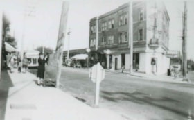
Edmonds Block, Edmonds and Kingsway
https://search.heritageburnaby.ca/link/archivedescription34039
- Repository
- City of Burnaby Archives
- Date
- [1912] (date of original), copied [between 1975 and 1985]
- Collection/Fonds
- Burnaby Historical Society fonds
- Description Level
- Item
- Physical Description
- 1 photograph : b&w negative ; 8.1 x 10.6 cm
- Scope and Content
- Photograph of the triangular Edmonds Block, located at Edmonds Street and Kingsway. The building on this block housed a store, a doctor's office, and a post office. Seen in the picture are various business signs, including, "P.C. Brown Auctioneer / Real Estate / Notary Public," "Edmonds Drug Store…
- Repository
- City of Burnaby Archives
- Date
- [1912] (date of original), copied [between 1975 and 1985]
- Collection/Fonds
- Burnaby Historical Society fonds
- Subseries
- Stride family subseries
- Physical Description
- 1 photograph : b&w negative ; 8.1 x 10.6 cm
- Description Level
- Item
- Record No.
- 001-015
- Access Restriction
- No restrictions
- Reproduction Restriction
- No known restrictions
- Accession Number
- BHS2007-04
- Scope and Content
- Photograph of the triangular Edmonds Block, located at Edmonds Street and Kingsway. The building on this block housed a store, a doctor's office, and a post office. Seen in the picture are various business signs, including, "P.C. Brown Auctioneer / Real Estate / Notary Public," "Edmonds Drug Store," "General Store," and "Dr. Watson Physician." Coming out from an alley behind the building is an unidentified man driving a horse and a cart. The streets are lined with electric poles.
- Media Type
- Photograph
- Notes
- Title based on contents of photograph
- 1 b&w copy print accompanying
- Geographic Access
- Edmonds Street
- Kingsway
- Street Address
- 7338 Kingsway
- Historic Neighbourhood
- Edmonds (Historic Neighbourhood)
- Planning Study Area
- Edmonds Area
Images
![Edmonds Block, Edmonds and Kingsway, [1912] (date of original), copied [between 1975 and 1985] thumbnail](/media/hpo/_Data/_Archives_Images/_Unrestricted/001/001-015.jpg)
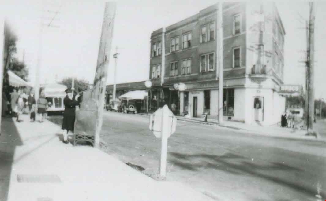
Edmonds Street and Kingsway
https://search.heritageburnaby.ca/link/archivedescription37823
- Repository
- City of Burnaby Archives
- Date
- 1944 (date of original), copied 1991
- Collection/Fonds
- Burnaby Historical Society fonds
- Description Level
- Item
- Physical Description
- 1 photograph : b&w ; 2.8 x 4.5 cm print on contact sheet 20.3 x 26.4 cm
- Scope and Content
- Photograph of the intersection of Edmonds Street and Kingsway. The triangular Edmonds Block can be seen at the right and Ruth Hollands is visible putting a letter in a mailbox.
- Repository
- City of Burnaby Archives
- Date
- 1944 (date of original), copied 1991
- Collection/Fonds
- Burnaby Historical Society fonds
- Subseries
- Burnaby Image Bank subseries
- Physical Description
- 1 photograph : b&w ; 2.8 x 4.5 cm print on contact sheet 20.3 x 26.4 cm
- Description Level
- Item
- Record No.
- 370-411
- Access Restriction
- No restrictions
- Reproduction Restriction
- No known restrictions
- Accession Number
- BHS1999-03
- Scope and Content
- Photograph of the intersection of Edmonds Street and Kingsway. The triangular Edmonds Block can be seen at the right and Ruth Hollands is visible putting a letter in a mailbox.
- Names
- Hollands, Ruth
- Media Type
- Photograph
- Notes
- Title based on contents of photograph
- 2 b&w copy prints accompanying
- 1 b&w copy negative accompanying
- Negative has a pink cast
- Geographic Access
- Edmonds Street
- Kingsway
- Historic Neighbourhood
- Edmonds (Historic Neighbourhood)
Images
![Relay for a Friend, [2000] thumbnail](/media/hpo/_Data/_Archives_Images/_Unrestricted/535/535-2877.jpg?width=280)
Relay for a Friend
https://search.heritageburnaby.ca/link/archivedescription97538
- Repository
- City of Burnaby Archives
- Date
- [2000]
- Collection/Fonds
- Burnaby NewsLeader photograph collection
- Description Level
- Item
- Physical Description
- 1 photograph (tiff) : col.
- Scope and Content
- Photograph of three unidentified postal workers who are holding packages and posing in a post office, next to a handmade sign that reads "Relay for a friend" and indicates a fundraising activity.
- Repository
- City of Burnaby Archives
- Date
- [2000]
- Collection/Fonds
- Burnaby NewsLeader photograph collection
- Physical Description
- 1 photograph (tiff) : col.
- Description Level
- Item
- Record No.
- 535-2877
- Access Restriction
- No restrictions
- Reproduction Restriction
- No restrictions
- Accession Number
- 2018-12
- Scope and Content
- Photograph of three unidentified postal workers who are holding packages and posing in a post office, next to a handmade sign that reads "Relay for a friend" and indicates a fundraising activity.
- Names
- Canada Post
- Media Type
- Photograph
- Notes
- Title based on contents of photograph
- Collected by editorial for use in an October 2000 issue of the Burnaby NewsLeader
Images
![Relay for a Friend, [2000] thumbnail](/media/hpo/_Data/_Archives_Images/_Unrestricted/535/535-2877.jpg)

Extension of McPherson Park School
https://search.heritageburnaby.ca/link/archivedescription36489
- Repository
- City of Burnaby Archives
- Date
- September 1959
- Collection/Fonds
- Burnaby Historical Society fonds
- Description Level
- Item
- Physical Description
- 1 photograph : b&w ; 8.5 x 12.5 cm print
- Scope and Content
- Photograph of the A.J. Keel house with excavation for the extension of the McPherson Park School.
- Repository
- City of Burnaby Archives
- Date
- September 1959
- Collection/Fonds
- Burnaby Historical Society fonds
- Subseries
- Keel family subseries
- Physical Description
- 1 photograph : b&w ; 8.5 x 12.5 cm print
- Description Level
- Item
- Record No.
- 279-002
- Access Restriction
- No restrictions
- Reproduction Restriction
- Reproduce for fair dealing purposes only
- Accession Number
- BHS1992-09
- Scope and Content
- Photograph of the A.J. Keel house with excavation for the extension of the McPherson Park School.
- Names
- McPherson Park School
- Media Type
- Photograph
- Notes
- Title based on contents of photograph
- Geographic Access
- Rumble Street
- Historic Neighbourhood
- Alta-Vista (Historic Neighbourhood)
- Planning Study Area
- Clinton-Glenwood Area
Images


Extension of McPherson Park School
https://search.heritageburnaby.ca/link/archivedescription36490
- Repository
- City of Burnaby Archives
- Date
- September 1959
- Collection/Fonds
- Burnaby Historical Society fonds
- Description Level
- Item
- Physical Description
- 1 photograph : b&w ; 8.5 x 12.5 cm print
- Scope and Content
- Photograph of the A.J. Keel house with a close-up of the excavation for the extension of McPherson Park School.
- Repository
- City of Burnaby Archives
- Date
- September 1959
- Collection/Fonds
- Burnaby Historical Society fonds
- Subseries
- Keel family subseries
- Physical Description
- 1 photograph : b&w ; 8.5 x 12.5 cm print
- Description Level
- Item
- Record No.
- 279-003
- Access Restriction
- No restrictions
- Reproduction Restriction
- Reproduce for fair dealing purposes only
- Accession Number
- BHS1992-09
- Scope and Content
- Photograph of the A.J. Keel house with a close-up of the excavation for the extension of McPherson Park School.
- Names
- McPherson Park School
- Media Type
- Photograph
- Notes
- Title based on contents of photograph
- Geographic Access
- Rumble Street
- Historic Neighbourhood
- Alta-Vista (Historic Neighbourhood)
- Planning Study Area
- Clinton-Glenwood Area
Images

![Parliament family home, the Half-House, [1928] thumbnail](/media/hpo/_Data/_Archives_Images/_Unrestricted/204/204-385.jpg?width=280)
Parliament family home, the Half-House
https://search.heritageburnaby.ca/link/archivedescription35527
- Repository
- City of Burnaby Archives
- Date
- [1928]
- Collection/Fonds
- Burnaby Historical Society fonds
- Description Level
- Item
- Physical Description
- 1 photograph : b&w ; 12.7 x 17.8 cm print
- Scope and Content
- Photograph of the Parliament family home, the famous landmark "half-house" on the 5770 block of Hastings Street, Capitol Hill. The photograph was taken looking north to Capitol Hill and Capitol Hill School is visible at the left.
- Repository
- City of Burnaby Archives
- Date
- [1928]
- Collection/Fonds
- Burnaby Historical Society fonds
- Subseries
- Pioneer Tales subseries
- Physical Description
- 1 photograph : b&w ; 12.7 x 17.8 cm print
- Description Level
- Item
- Record No.
- 204-385
- Access Restriction
- No restrictions
- Reproduction Restriction
- No known restrictions
- Accession Number
- BHS1988-03
- Scope and Content
- Photograph of the Parliament family home, the famous landmark "half-house" on the 5770 block of Hastings Street, Capitol Hill. The photograph was taken looking north to Capitol Hill and Capitol Hill School is visible at the left.
- Names
- Capitol Hill School
- Media Type
- Photograph
- Notes
- Title based on contents of photograph
- Annotations on top and bottom of photograph read, "The 'Half House'" / "Taken from 'The Tree'"
- Geographic Access
- Hastings Street
- Historic Neighbourhood
- Capitol Hill (Historic Neighbourhood)
- Planning Study Area
- Parkcrest-Aubrey Area
Images
![Parliament family home, the Half-House, [1928] thumbnail](/media/hpo/_Data/_Archives_Images/_Unrestricted/204/204-385.jpg)
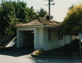
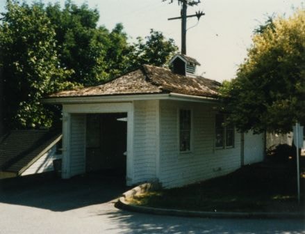
Oakalla Warden's House
https://search.heritageburnaby.ca/link/archivedescription34854
- Repository
- City of Burnaby Archives
- Date
- 1985
- Collection/Fonds
- Burnaby Historical Society fonds
- Description Level
- Item
- Physical Description
- 1 photograph : col. ; 8.8 x 11.3 cm
- Scope and Content
- Photograph of the Warden's house and garage at Oakalla Prison Farm, Royal Oak Road.
- Repository
- City of Burnaby Archives
- Date
- 1985
- Collection/Fonds
- Burnaby Historical Society fonds
- Subseries
- Evelyn Salisbury subseries
- Physical Description
- 1 photograph : col. ; 8.8 x 11.3 cm
- Description Level
- Item
- Record No.
- 145-002
- Access Restriction
- No restrictions
- Reproduction Restriction
- Reproduce for fair dealing purposes only
- Accession Number
- BHS1985-15
- Scope and Content
- Photograph of the Warden's house and garage at Oakalla Prison Farm, Royal Oak Road.
- Names
- Oakalla Prison Farm
- Media Type
- Photograph
- Notes
- Title based on contents of photograph
- Geographic Access
- Oakmount Crescent
- Street Address
- 5220 Oakmount Crescent
- Historic Neighbourhood
- Burnaby Lake (Historic Neighbourhood)
- Planning Study Area
- Oakalla Area
Images
4322-4342 Victory St
https://search.heritageburnaby.ca/link/archivedescription93770
- Repository
- City of Burnaby Archives
- Date
- August 1992
- Collection/Fonds
- Grover, Elliott & Co. Ltd. fonds
- Description Level
- File
- Physical Description
- 56 photographs : col. negatives ; 35 mm
- Scope and Content
- Photographs of the houses located between 4322-4342 Victory Street - addresses that no longer exist. The Skytrain Expo line is visible in the background of some photographs.
- Repository
- City of Burnaby Archives
- Date
- August 1992
- Collection/Fonds
- Grover, Elliott & Co. Ltd. fonds
- Physical Description
- 56 photographs : col. negatives ; 35 mm
- Description Level
- File
- Record No.
- 622-054
- Access Restriction
- No restrictions
- Reproduction Restriction
- No restrictions
- Accession Number
- 2017-39
- Scope and Content
- Photographs of the houses located between 4322-4342 Victory Street - addresses that no longer exist. The Skytrain Expo line is visible in the background of some photographs.
- Media Type
- Photograph
- Notes
- Transcribed title
- Title transcribed from envelope photographs were originally housed in
- File no. 92-304-B
- Geographic Access
- Victory Street
- Historic Neighbourhood
- Alta Vista (Historic Neighbourhood)
- Planning Study Area
- Maywood Area

Administration Building New Haven Borstal
https://search.heritageburnaby.ca/link/archivedescription93663
- Repository
- City of Burnaby Archives
- Date
- January 15, 1978
- Collection/Fonds
- Burnaby Public Library Contemporary Visual Archive Project
- Description Level
- Item
- Physical Description
- 1 photograph : b&w ; 12.5 x 17.5 cm
- Scope and Content
- Photograph of the exterior of the administration building at the New Haven Borstal Institute. The photograph is taken from across the lawn, facing northwest. A man is looking into the window of the building on the left.
- Repository
- City of Burnaby Archives
- Date
- January 15, 1978
- Collection/Fonds
- Burnaby Public Library Contemporary Visual Archive Project
- Physical Description
- 1 photograph : b&w ; 12.5 x 17.5 cm
- Description Level
- Item
- Record No.
- 556-620
- Access Restriction
- No restrictions
- Reproduction Restriction
- Reproduce for fair dealing purposes only
- Accession Number
- 2017-57
- Scope and Content
- Photograph of the exterior of the administration building at the New Haven Borstal Institute. The photograph is taken from across the lawn, facing northwest. A man is looking into the window of the building on the left.
- Subjects
- Buildings - Public - Detention Facilities
- Buildings - Schools
- Buildings - Heritage
- Government - Provincial Government
- Media Type
- Photograph
- Photographer
- Surridge, Jack
- Notes
- Title taken from project information form
- Accompanied by a project information form and 1 photograph (b&w negative ; 9.5 x 12.5 cm)
- BPL no. 69
- Street Address
- 4520 Marine Drive
- Historic Neighbourhood
- Fraser Arm (Historic Neighbourhood)
- Planning Study Area
- Big Bend Area
Images


New Haven Borstal (Barn)
https://search.heritageburnaby.ca/link/archivedescription93662
- Repository
- City of Burnaby Archives
- Date
- January 15, 1978
- Collection/Fonds
- Burnaby Public Library Contemporary Visual Archive Project
- Description Level
- Item
- Physical Description
- 1 photograph : b&w ; 12.5 x 17.5 cm
- Scope and Content
- Photograph of the exterior of the barn at the New Haven Borstal Institute, located at 4250 Marine Drive. The photograph is taken facing northeast. New Haven operated out of the Glen-Lyon Estate, which the provincial government purchased in 1939.
- Repository
- City of Burnaby Archives
- Date
- January 15, 1978
- Collection/Fonds
- Burnaby Public Library Contemporary Visual Archive Project
- Physical Description
- 1 photograph : b&w ; 12.5 x 17.5 cm
- Description Level
- Item
- Record No.
- 556-619
- Access Restriction
- No restrictions
- Reproduction Restriction
- Reproduce for fair dealing purposes only
- Accession Number
- 2017-57
- Scope and Content
- Photograph of the exterior of the barn at the New Haven Borstal Institute, located at 4250 Marine Drive. The photograph is taken facing northeast. New Haven operated out of the Glen-Lyon Estate, which the provincial government purchased in 1939.
- Subjects
- Buildings - Public - Detention Facilities
- Buildings - Schools
- Government - Provincial Government
- Buildings - Heritage
- Media Type
- Photograph
- Photographer
- Hauger, C.
- Notes
- Title taken from project information form
- Accompanied by a project information form and 1 photograph (b&w negative ; 9.5 x 12.5 cm)
- BPL no. 68
- Geographic Access
- Marine Drive
- Street Address
- 4250 Marine Drive
- Historic Neighbourhood
- Fraser Arm (Historic Neighbourhood)
- Planning Study Area
- Big Bend Area
Images


New Haven Borstal Main Building
https://search.heritageburnaby.ca/link/archivedescription93665
- Repository
- City of Burnaby Archives
- Date
- January 15, 1978
- Collection/Fonds
- Burnaby Public Library Contemporary Visual Archive Project
- Description Level
- Item
- Physical Description
- 1 photograph : b&w ; 12.5 x 17.5 cm
- Scope and Content
- Photograph of the side exterior of the main building of the New Haven Borstal Institute, located at 4250 Marine Drive. The main building is the old mansion of the Glen-Lyon estate, which the provincial government purchased in 1939. The photograph is taken from the sidewalk, facing northeast.
- Repository
- City of Burnaby Archives
- Date
- January 15, 1978
- Collection/Fonds
- Burnaby Public Library Contemporary Visual Archive Project
- Physical Description
- 1 photograph : b&w ; 12.5 x 17.5 cm
- Description Level
- Item
- Record No.
- 556-622
- Access Restriction
- No restrictions
- Reproduction Restriction
- Reproduce for fair dealing purposes only
- Accession Number
- 2017-57
- Scope and Content
- Photograph of the side exterior of the main building of the New Haven Borstal Institute, located at 4250 Marine Drive. The main building is the old mansion of the Glen-Lyon estate, which the provincial government purchased in 1939. The photograph is taken from the sidewalk, facing northeast.
- Subjects
- Buildings - Public - Detention Facilities
- Buildings - Schools
- Buildings - Heritage
- Government - Provincial Government
- Media Type
- Photograph
- Photographer
- Roberts, S.
- Notes
- Title taken from project information form
- Accompanied by a project information form and 1 photograph (b&w negative ; 9.5 x 12.5 cm)
- BPL no. 71
- Geographic Access
- Marine Drive
- Street Address
- 4250 Marine Drive
- Historic Neighbourhood
- Fraser Arm (Historic Neighbourhood)
- Planning Study Area
- Big Bend Area
Images


New Haven Borstal Main Building
https://search.heritageburnaby.ca/link/archivedescription93667
- Repository
- City of Burnaby Archives
- Date
- January 15, 1978
- Collection/Fonds
- Burnaby Public Library Contemporary Visual Archive Project
- Description Level
- Item
- Physical Description
- 1 photograph : b&w ; 12.5 x 17.5 cm
- Scope and Content
- Photograph of the side exterior of the main building of the New Haven Borstal Institute, located at 4250 Marine Drive. The main building is the old mansion of the Glen-Lyon estate, which the provincial government purchased in 1939. The photograph is taken from the sidewalk, facing northwest.
- Repository
- City of Burnaby Archives
- Date
- January 15, 1978
- Collection/Fonds
- Burnaby Public Library Contemporary Visual Archive Project
- Physical Description
- 1 photograph : b&w ; 12.5 x 17.5 cm
- Description Level
- Item
- Record No.
- 556-624
- Access Restriction
- No restrictions
- Reproduction Restriction
- Reproduce for fair dealing purposes only
- Accession Number
- 2017-57
- Scope and Content
- Photograph of the side exterior of the main building of the New Haven Borstal Institute, located at 4250 Marine Drive. The main building is the old mansion of the Glen-Lyon estate, which the provincial government purchased in 1939. The photograph is taken from the sidewalk, facing northwest.
- Subjects
- Buildings - Public - Detention Facilities
- Buildings - Schools
- Buildings - Heritage
- Government - Provincial Government
- Media Type
- Photograph
- Photographer
- Hauger, C.
- Notes
- Title taken from project information form
- Accompanied by a project information form and 1 photograph (b&w negative ; 9.5 x 12.5 cm)
- BPL no. 73
- Geographic Access
- Marine Drive
- Street Address
- 4250 Marine Drive
- Historic Neighbourhood
- Fraser Arm (Historic Neighbourhood)
- Planning Study Area
- Big Bend Area
Images


New Haven Borstal Workshop
https://search.heritageburnaby.ca/link/archivedescription93666
- Repository
- City of Burnaby Archives
- Date
- January 15, 1978
- Collection/Fonds
- Burnaby Public Library Contemporary Visual Archive Project
- Description Level
- Item
- Physical Description
- 1 photograph : b&w ; 12.5 x 17.5 cm
- Scope and Content
- Photograph of the exterior of the workshop at the New Haven Borstal Institute, located across the street from the main building at 4250 Marine Drive. The photograph is taken from across the lawn, facing northeast. Cars are parked outside the workshop and the front of the main building, previously t…
- Repository
- City of Burnaby Archives
- Date
- January 15, 1978
- Collection/Fonds
- Burnaby Public Library Contemporary Visual Archive Project
- Physical Description
- 1 photograph : b&w ; 12.5 x 17.5 cm
- Description Level
- Item
- Record No.
- 556-623
- Access Restriction
- No restrictions
- Reproduction Restriction
- Reproduce for fair dealing purposes only
- Accession Number
- 2017-57
- Scope and Content
- Photograph of the exterior of the workshop at the New Haven Borstal Institute, located across the street from the main building at 4250 Marine Drive. The photograph is taken from across the lawn, facing northeast. Cars are parked outside the workshop and the front of the main building, previously the Glen-Lyon estate mansion, is visible in the background.
- Subjects
- Buildings - Public - Detention Facilities
- Buildings - Schools
- Buildings - Heritage
- Government - Provincial Government
- Media Type
- Photograph
- Photographer
- Roberts, S.
- Notes
- Title taken from project information form
- Accompanied by a project information form and 1 photograph (b&w negative ; 9.5 x 12.5 cm)
- BPL no. 72
- Geographic Access
- Marine Drive
- Street Address
- 4250 Marine Drive
- Historic Neighbourhood
- Fraser Arm (Historic Neighbourhood)
- Planning Study Area
- Big Bend Area
Images

![School room at Oakalla, [195-] (date of original), copied 1991 thumbnail](/media/hpo/_Data/_Archives_Images/_Unrestricted/370/370-733.jpg?width=280)
School room at Oakalla
https://search.heritageburnaby.ca/link/archivedescription38146
- Repository
- City of Burnaby Archives
- Date
- [195-] (date of original), copied 1991
- Collection/Fonds
- Burnaby Historical Society fonds
- Description Level
- Item
- Physical Description
- 1 photograph : b&w ; 3.6 x 4.4 cm print on contact sheet 20.6 x 26.8 cm
- Scope and Content
- Photograph of the interior of a school room at Oakalla Prison Farm. Men are seated at desks, and a student and teacher are at the blackboard standing beside a map. A list of words is on the blackboard.
- Repository
- City of Burnaby Archives
- Date
- [195-] (date of original), copied 1991
- Collection/Fonds
- Burnaby Historical Society fonds
- Subseries
- Burnaby Image Bank subseries
- Physical Description
- 1 photograph : b&w ; 3.6 x 4.4 cm print on contact sheet 20.6 x 26.8 cm
- Description Level
- Item
- Record No.
- 370-733
- Access Restriction
- No restrictions
- Reproduction Restriction
- Reproduce for fair dealing purposes only
- Accession Number
- BHS1999-03
- Scope and Content
- Photograph of the interior of a school room at Oakalla Prison Farm. Men are seated at desks, and a student and teacher are at the blackboard standing beside a map. A list of words is on the blackboard.
- Subjects
- Documentary Artifacts - Maps
- Buildings - Public - Detention Facilities
- Buildings - Schools
- Occupations - Teachers
- Names
- Oakalla Prison Farm
- Media Type
- Photograph
- Notes
- Title based on contents of photograph
- 1 b&w copy negative accompanying
- Negative has a pink cast
- Geographic Access
- Oakmount Crescent
- Street Address
- 5220 Oakmount Crescent
- Historic Neighbourhood
- Burnaby Lake (Historic Neighbourhood)
- Planning Study Area
- Oakalla Area
Images
![School room at Oakalla, [195-] (date of original), copied 1991 thumbnail](/media/hpo/_Data/_Archives_Images/_Unrestricted/370/370-733.jpg)
6900 [and] 7000 bk Hastings St. / 7000 blk Pandora St. 200 [and] 300 blks Cliff Ave Burnaby
https://search.heritageburnaby.ca/link/archivedescription94205
- Repository
- City of Burnaby Archives
- Date
- November 1993 - December 1993
- Collection/Fonds
- Grover, Elliott & Co. Ltd. fonds
- Description Level
- File
- Physical Description
- 96 photographs : col. negatives ; 35 mm
- Scope and Content
- Photographs of various residential and commercial streets in Burnaby.
- Repository
- City of Burnaby Archives
- Date
- November 1993 - December 1993
- Collection/Fonds
- Grover, Elliott & Co. Ltd. fonds
- Physical Description
- 96 photographs : col. negatives ; 35 mm
- Description Level
- File
- Record No.
- 622-080
- Access Restriction
- No restrictions
- Reproduction Restriction
- No restrictions
- Accession Number
- 2017-39
- Scope and Content
- Photographs of various residential and commercial streets in Burnaby.
- Subjects
- Geographic Features - Roads
- Buildings - Residential - Apartments
- Buildings - Residential - Houses
- Buildings - Commercial
- Media Type
- Photograph
- Notes
- Transcribed title
- Title transcribed from envelope photographs were originally housed in
- File no. 93-455-B
- Note on negative envelope housing photographs 622-080-1 : 622-080-74 reads: "93-11-26 / Inlet Dr/Hastings, Bby, / 93-455-B"
- Note on negative envelope housing photographs 622-080-75 : 622-080-96 reads: "93-12-01 / Comp's / 93-455"
- Photographer identified as "K.H."
- Geographic Access
- Hastings Street
- Cliff Avenue
- Pandora Street

7530 Buller Avenue
https://search.heritageburnaby.ca/link/archivedescription98686
- Repository
- City of Burnaby Archives
- Date
- 2022
- Collection/Fonds
- Disappearing Burnaby collection
- Description Level
- Item
- Physical Description
- 1 photograph (jpeg) : col.
- Scope and Content
- Photograph of the exterior of a two-storey house located at 7530 Buller Avenue. The photograph depicts the house at dusk; the house stands behind a wooden fence and is surrounded by trees. The house was constructed in 1924 and was formerly known as "Ryverbrae," the William & Esther Burdick Residenc…
- Repository
- City of Burnaby Archives
- Date
- 2022
- Collection/Fonds
- Disappearing Burnaby collection
- Physical Description
- 1 photograph (jpeg) : col.
- Description Level
- Item
- Record No.
- 634-033
- Access Restriction
- No restrictions
- Reproduction Restriction
- No restrictions
- Accession Number
- 2022-14
- Scope and Content
- Photograph of the exterior of a two-storey house located at 7530 Buller Avenue. The photograph depicts the house at dusk; the house stands behind a wooden fence and is surrounded by trees. The house was constructed in 1924 and was formerly known as "Ryverbrae," the William & Esther Burdick Residence.
- Media Type
- Photograph
- Photographer
- Cheung, Nakita
- Notes
- Title taken from the associated blog post
- Associated blog post: https://disappearingburnaby.wordpress.com/2022/06/30/william-esther-burdick-residence/
- Geographic Access
- Buller Avenue
- Street Address
- 7530 Buller Avenue
- Historic Neighbourhood
- Alta Vista (Historic Neighbourhood)
- Planning Study Area
- Clinton-Glenwood Area
Images


Brookes family home, "Normanna"
https://search.heritageburnaby.ca/link/archivedescription35246
- Repository
- City of Burnaby Archives
- Date
- 1927
- Collection/Fonds
- Burnaby Historical Society fonds
- Description Level
- Item
- Physical Description
- 1 photograph : b&w ; 12.7 x 17.8 cm print
- Scope and Content
- Photograph of "Normanna," the Brookes family residence. This new Brookes family home was built in 1927 on the same site as the original house at 441 12th Avenue (later renumbered 7979 12th Avenue). Eventually, this became Normanna Norwegian rest home. The original house was built by Burnaby's firs…
- Repository
- City of Burnaby Archives
- Date
- 1927
- Collection/Fonds
- Burnaby Historical Society fonds
- Subseries
- Pioneer Tales subseries
- Physical Description
- 1 photograph : b&w ; 12.7 x 17.8 cm print
- Description Level
- Item
- Record No.
- 204-103
- Access Restriction
- No restrictions
- Reproduction Restriction
- No known restrictions
- Accession Number
- BHS1988-03
- Scope and Content
- Photograph of "Normanna," the Brookes family residence. This new Brookes family home was built in 1927 on the same site as the original house at 441 12th Avenue (later renumbered 7979 12th Avenue). Eventually, this became Normanna Norwegian rest home. The original house was built by Burnaby's first Reeve, Charles Shaw, and is now a designated heritage site at 7725 4th Street.
- Subjects
- Geographic Features - Gardens
- Buildings - Residential - Houses
- Buildings - Residential - Seniors Housing
- Buildings - Heritage
- Names
- Normanna Rest Home
- Media Type
- Photograph
- Notes
- Title based on contents of photograph
- Geographic Access
- 4th Street
- Street Address
- 7725 4th Street
- Historic Neighbourhood
- East Burnaby (Historic Neighbourhood)
- Planning Study Area
- Second Street Area
Images
