More like 'Warehouses - Burnaby Lake'
Narrow Results By
Subject
- Accidents
- Accidents - Automobile Accidents 1
- Adornment 1
- Advertising Medium
- Advertising Medium - Signs and Signboards 96
- Aerial Photographs 28
- Agricultural Tools and Equipment - Plows 3
- Agriculture 4
- Agriculture - Crops 2
- Agriculture - Dairy 1
- Agriculture - Farms 57
- Agriculture - Fruit and Berries 8
![Go Pages promotion at Petro-Canada, [2003] thumbnail](/media/hpo/_Data/_Archives_Images/_Unrestricted/535/535-2280.jpg?width=280)
Go Pages promotion at Petro-Canada
https://search.heritageburnaby.ca/link/archivedescription96658
- Repository
- City of Burnaby Archives
- Date
- [2003]
- Collection/Fonds
- Burnaby NewsLeader photograph collection
- Description Level
- Item
- Physical Description
- 1 photograph (tiff) : col.
- Scope and Content
- Photograph of Richard Samuda of Go Pages yelling through a bullhorn at the Petro-Canada gas station at Lougheed and Willingdon. Samuda is advertising free gas as a promotion for Go Pages' launch.
- Repository
- City of Burnaby Archives
- Date
- [2003]
- Collection/Fonds
- Burnaby NewsLeader photograph collection
- Physical Description
- 1 photograph (tiff) : col.
- Description Level
- Item
- Record No.
- 535-2280
- Access Restriction
- No restrictions
- Reproduction Restriction
- No restrictions
- Accession Number
- 2018-12
- Scope and Content
- Photograph of Richard Samuda of Go Pages yelling through a bullhorn at the Petro-Canada gas station at Lougheed and Willingdon. Samuda is advertising free gas as a promotion for Go Pages' launch.
- Media Type
- Photograph
- Photographer
- Bartel, Mario
- Notes
- Title based on caption
- Collected by editorial for use in a March 2003 issue of the Burnaby NewsLeader
- Caption from metadata: "Richard Samuda invites drivers into the Petro-Canada station at Lougheed and Willingdon to gas up for free, to promote the launch of Go Pages. The team of guerrilla gas jockies descended unanounced on stations around the Lower Mainland for three days, pumping about 1000 tanks of free gas."
- Geographic Access
- Lougheed Highway
- Willingdon Avenue
- Planning Study Area
- Brentwood Area
Images
![Go Pages promotion at Petro-Canada, [2003] thumbnail](/media/hpo/_Data/_Archives_Images/_Unrestricted/535/535-2280.jpg)
![Hotel Burnaby, [1953] thumbnail](/media/hpo/_Data/_Archives_Images/_Unrestricted/371/410-001.jpg?width=280)
Hotel Burnaby
https://search.heritageburnaby.ca/link/archivedescription38341
- Repository
- City of Burnaby Archives
- Date
- [1953]
- Collection/Fonds
- Burnaby Historical Society fonds
- Description Level
- Item
- Physical Description
- 1 photograph : b&w postcard ; 8.7 x 13.1 cm
- Scope and Content
- Photographic postcard advertising the Hotel Burnaby at 1385 Kingsway (old street numbering). A caption on the reverse of the postcard reads: Hotel Burnaby / :Located between new Simpsons-Sears and new Woodwards shopping centres / You will remember Hotel Burnaby for the REST of your life."
- Repository
- City of Burnaby Archives
- Date
- [1953]
- Collection/Fonds
- Burnaby Historical Society fonds
- Subseries
- Jim Wolf subseries
- Physical Description
- 1 photograph : b&w postcard ; 8.7 x 13.1 cm
- Description Level
- Item
- Record No.
- 410-001
- Access Restriction
- No restrictions
- Reproduction Restriction
- Reproduce for fair dealing purposes only
- Accession Number
- BHS2000-11
- Scope and Content
- Photographic postcard advertising the Hotel Burnaby at 1385 Kingsway (old street numbering). A caption on the reverse of the postcard reads: Hotel Burnaby / :Located between new Simpsons-Sears and new Woodwards shopping centres / You will remember Hotel Burnaby for the REST of your life."
- Subjects
- Advertising Medium
- Documentary Artifacts - Postcards
- Buildings - Commercial - Hotels and Motels
- Names
- Hotel Burnaby Limited
- Media Type
- Photograph
- Notes
- Title based on contents of photograph
- Geographic Access
- Kingsway
- Historic Neighbourhood
- Edmonds (Historic Neighbourhood)
- Planning Study Area
- Stride Avenue Area
Images
![Hotel Burnaby, [1953] thumbnail](/media/hpo/_Data/_Archives_Images/_Unrestricted/371/410-001.jpg)
![Hotel Burnaby Ltd., [1955] thumbnail](/media/hpo/_Data/_Archives_Images/_Unrestricted/371/474-001.jpg?width=280)
Hotel Burnaby Ltd.
https://search.heritageburnaby.ca/link/archivedescription38656
- Repository
- City of Burnaby Archives
- Date
- [1955]
- Collection/Fonds
- Burnaby Historical Society fonds
- Description Level
- Item
- Physical Description
- 1 photograph : col. postcard ; 9 x 14 cm
- Scope and Content
- Photographic postcard of Burnaby Hotel located at 1385 Kingsway (old street numbering system). Printed at the bottom of the postcard is the following: Hotel Burnaby Ltd. / 1385 Kingsway at 14th Avenue / Burnaby 3, New Westminster, B.C., Telephone LA 1-8891. On the reverse is written: "Hotel Burna…
- Repository
- City of Burnaby Archives
- Date
- [1955]
- Collection/Fonds
- Burnaby Historical Society fonds
- Subseries
- Jim Wolf subseries
- Physical Description
- 1 photograph : col. postcard ; 9 x 14 cm
- Description Level
- Item
- Record No.
- 474-001
- Access Restriction
- No restrictions
- Reproduction Restriction
- Reproduce for fair dealing purposes only
- Accession Number
- BHS2005-6
- Scope and Content
- Photographic postcard of Burnaby Hotel located at 1385 Kingsway (old street numbering system). Printed at the bottom of the postcard is the following: Hotel Burnaby Ltd. / 1385 Kingsway at 14th Avenue / Burnaby 3, New Westminster, B.C., Telephone LA 1-8891. On the reverse is written: "Hotel Burnaby: Located between new Simpson-Sears and new Woodwards shopping centres. You will remember Hotel Burnaby for the rest of your life."
- Subjects
- Buildings - Commercial - Hotels and Motels
- Documentary Artifacts - Postcards
- Advertising Medium
- Names
- Hotel Burnaby Limited
- Media Type
- Photograph
- Photographer
- Grant-Mann Lithographers Limited
- Notes
- Title based on caption of postcard
- Made by Grant-Mann Lithographers Ltd. "Colour Card" Division, Vancouver British Columbia
- Geographic Access
- Kingsway
- Historic Neighbourhood
- Edmonds (Historic Neighbourhood)
- Planning Study Area
- Stride Avenue Area
Images
![Hotel Burnaby Ltd., [1955] thumbnail](/media/hpo/_Data/_Archives_Images/_Unrestricted/371/474-001.jpg)
placemat
https://search.heritageburnaby.ca/link/museumartifact91017
- Repository
- Burnaby Village Museum
- Accession Code
- BV021.11.19
- Description
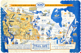
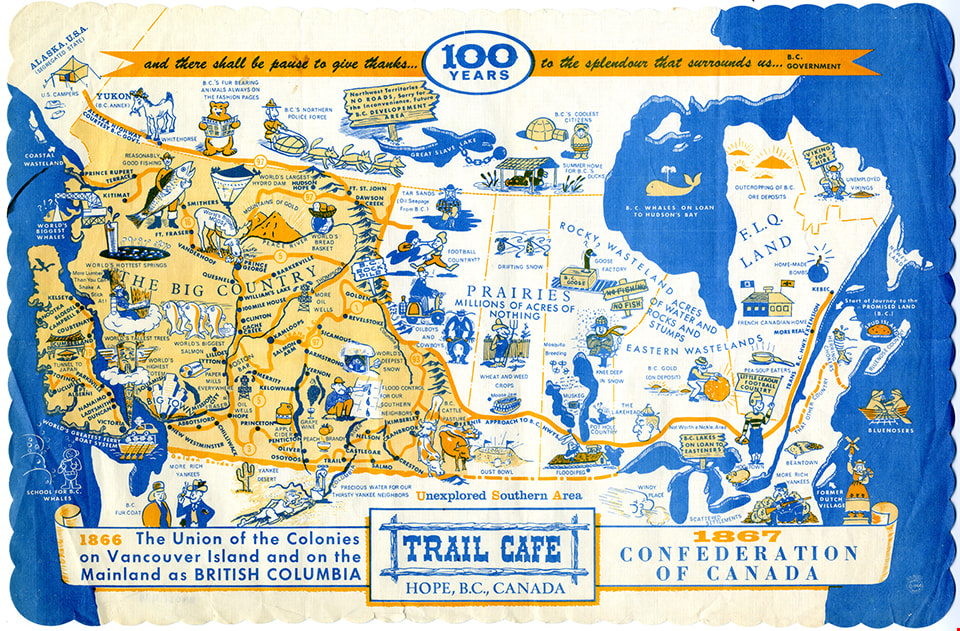
- placemat; paper promotional placemat with scalloped edges; coloured white, blue and yellow cartoon illustration map of Canada with British Columbia in yellow and oversized. At top: "and there shall be a pause to give thanks..100 YEARS..to the splendor that surrounds us..BC GOVERNMENT" and "TRAIL CAFE / HOPE, B.C., CANADA" at the centre bottom. "1866 The Union of the Colonies on Vancouver Island and on the Mainland as BRITISH COLUMBIA" and "1867 CONFEDERATION OF CANADA" Some folding at corners and brown stain over upper Pacific coast area.
- Object History
- Souvenir placemat was made available as a commemorative item in celebrating Confederation Centennial of British Columbia.
- Category
- 04.Tools & Equipment for Materials
- Classification
- Food Service T&E - - Food Service Accessories
- Object Term
- Placemat
- Marks/Labels
- "G.H. WOOD"; "Printed 1966 Canada"
- Measurements
- Length: 24.5 cm x Width: 37 cm
- Subjects
- Events
- Events - Anniversaries
- Advertising Medium
- Buildings - Commercial - Restaurants
- Food Service Tools and Equipment
Images

Original Second Narrows Bridge collapses
https://search.heritageburnaby.ca/link/museumdescription104
- Repository
- Burnaby Village Museum
- Date
- 1930
- Collection/Fonds
- Burnaby Village Museum Photograph collection
- Description Level
- Item
- Physical Description
- 1 photograph : sepia ; 6 x 10.5 cm
- Scope and Content
- Photograph of the aftermath of the Second Narrows Bridge being hit by the"Losmar" pictured on the right. Soon after being built in 1925, the Second Narrows Bridge was hit countless times by ships at the bascule portion installed at the south end of the bridge (unfortunately installed in a shallow w…
- Repository
- Burnaby Village Museum
- Collection/Fonds
- Burnaby Village Museum Photograph collection
- Description Level
- Item
- Physical Description
- 1 photograph : sepia ; 6 x 10.5 cm
- Scope and Content
- Photograph of the aftermath of the Second Narrows Bridge being hit by the"Losmar" pictured on the right. Soon after being built in 1925, the Second Narrows Bridge was hit countless times by ships at the bascule portion installed at the south end of the bridge (unfortunately installed in a shallow water area to avoid building expensive towers and a lift span). Each time it was hit the bridge was out of commission until it was repaired. The Second Narrows Bridge runs over Burrard Inlet and connects Vancouver to North Vancouver.
- Subjects
- Structures - Bridges
- Accidents
- Accession Code
- BV988.31.6
- Access Restriction
- No restrictions
- Date
- 1930
- Media Type
- Photograph
- Related Material
- For another photograph of the collapse of the Second Narrows Bridge, see BV988.31.7
- Scan Resolution
- 600
- Scan Date
- 2024-04-16
- Notes
- Title based on contents of photograph
- Note in blue pen on verso of photograph reads: "Collapse of original 2nd Narrows Bridge / year?"
Images

![Original Second Narrows Bridge collapses, [between 1925 and 1930] thumbnail](/media/hpo/_Data/_BVM_Images/1988/1988_0031_0007_001.jpg?width=280)
Original Second Narrows Bridge collapses
https://search.heritageburnaby.ca/link/museumdescription105
- Repository
- Burnaby Village Museum
- Date
- [between 1925 and 1930]
- Collection/Fonds
- Burnaby Village Museum Photograph collection
- Description Level
- Item
- Physical Description
- 1 photograph : sepia ; 6 x 10 cm
- Scope and Content
- Photograph of the aftermath of the Second Narrows Bridge being hit by a ship. The span girder is tipped into water on the left side of the photograph and the other girder is broken and in upright position. There is a large ship in the front with letters "CALMAR LINE" written on the side along with …
- Repository
- Burnaby Village Museum
- Collection/Fonds
- Burnaby Village Museum Photograph collection
- Description Level
- Item
- Physical Description
- 1 photograph : sepia ; 6 x 10 cm
- Scope and Content
- Photograph of the aftermath of the Second Narrows Bridge being hit by a ship. The span girder is tipped into water on the left side of the photograph and the other girder is broken and in upright position. There is a large ship in the front with letters "CALMAR LINE" written on the side along with several tug boats. Soon after being built in 1925, the Second Narrows Bridge was hit countless times by ships at the bascule portion installed at the south end of the bridge (unfortunately installed in a shallow water area to avoid building expensive towers and a lift span). Each time it was hit the bridge was out of commission until it was repaired. The Second Narrows Bridge runs over Burrard Inlet and connects Vancouver to North Vancouver.
- Subjects
- Structures - Bridges
- Accidents
- Accession Code
- BV988.31.7
- Access Restriction
- No restrictions
- Date
- [between 1925 and 1930]
- Media Type
- Photograph
- Related Material
- For another photograph of the collapse of the Second Narrows Bridge, see BV988.31.6
- Scan Resolution
- 600
- Scan Date
- 2024-04-16
- Notes
- Title based on contents of photograph
- Note in blue pen on verso of photograph reads: "Collapse of original 2nd Narrows Bridge / year?"
Images
![Original Second Narrows Bridge collapses, [between 1925 and 1930] thumbnail](/media/hpo/_Data/_BVM_Images/1988/1988_0031_0007_001.jpg)
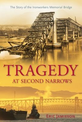
Tragedy at Second Narrows : the story of the Ironworkers Memorial Bridge
https://search.heritageburnaby.ca/link/museumlibrary1384
- Repository
- Burnaby Village Museum
- Author
- Jamieson, Eric, 1949-
- Publication Date
- c2008
- Call Number
- 624.2 JAM
- Repository
- Burnaby Village Museum
- Collection
- Reference Collection
- Material Type
- Book
- ISBN
- 9781550174519
- Call Number
- 624.2 JAM
- Author
- Jamieson, Eric, 1949-
- Place of Publication
- Maderia Park, BC
- Publisher
- Harbour
- Publication Date
- c2008
- Physical Description
- 301 p. : ill.
- Inscription
- "E.J.", Initials in black ink on subtitle page
- Library Subject (LOC)
- Bridges
- Subjects
- Structures - Bridges
- Accidents
- Geographic Access
- Vancouver
- Notes
- Includes bibliographical references and index
- Signed by author