More like 'Volunteers clearing site for Lozells Hall'
Narrow Results By
Subject
- Accidents 6
- Accidents - Automobile Accidents 9
- Accidents - Train Accidents 9
- Advertising Medium 2
- Advertising Medium - Signs and Signboards 19
- Aerial Photographs 2
- Agricultural Tools and Equipment 11
- Agricultural Tools and Equipment - Gardening Equipment 2
- Agricultural Tools and Equipment - Plows 9
- Agriculture 1
- Agriculture - Crops 16
- Agriculture - Farms 12

Digging In
https://search.heritageburnaby.ca/link/archivedescription34387
- Repository
- City of Burnaby Archives
- Date
- 1926
- Collection/Fonds
- Burnaby Historical Society fonds
- Description Level
- Item
- Physical Description
- 1 photograph : b&w ; 7.5 x 7 cm on page 17.5 x 26.5 cm
- Scope and Content
- Photograph of a steam shovel digging into a hill. A horse team pulling a dump wagon stand next to it. The location is unknown. This photograph appears to have been taken by Arthur Peers, who travelled through the Fraser River Valley and worked on the construction of the Trans-Provincial Highway dur…
- Repository
- City of Burnaby Archives
- Date
- 1926
- Collection/Fonds
- Burnaby Historical Society fonds
- Subseries
- Peers family subseries
- Physical Description
- 1 photograph : b&w ; 7.5 x 7 cm on page 17.5 x 26.5 cm
- Description Level
- Item
- Record No.
- 020-094
- Access Restriction
- No restrictions
- Reproduction Restriction
- No known restrictions
- Accession Number
- BHS2007-04
- Scope and Content
- Photograph of a steam shovel digging into a hill. A horse team pulling a dump wagon stand next to it. The location is unknown. This photograph appears to have been taken by Arthur Peers, who travelled through the Fraser River Valley and worked on the construction of the Trans-Provincial Highway during the later 1920s.
- Subjects
- Land Clearing
- Occupations - Labourers
- Transportation - Horses
- Transportation - Wagons
- Construction Tools and Equipment
- Media Type
- Photograph
- Photographer
- Peers, Arthur Francis "Mike"
- Notes
- Title based on caption accompanying photograph
Images

![Land clearing crew, [1912] (date of original), copied 1991 thumbnail](/media/hpo/_Data/_Archives_Images/_Unrestricted/370/370-778.jpg?width=280)
Land clearing crew
https://search.heritageburnaby.ca/link/archivedescription38191
- Repository
- City of Burnaby Archives
- Date
- [1912] (date of original), copied 1991
- Collection/Fonds
- Burnaby Historical Society fonds
- Description Level
- Item
- Physical Description
- 1 photograph : b&w ; 3.2 x 4.8 cm print on contact sheet 20.4 x 26.5 cm
- Scope and Content
- Photograph of a land clearing crew, with horses and tools, in the Metrotown area near McKay Avenue.
- Repository
- City of Burnaby Archives
- Date
- [1912] (date of original), copied 1991
- Collection/Fonds
- Burnaby Historical Society fonds
- Subseries
- Burnaby Image Bank subseries
- Physical Description
- 1 photograph : b&w ; 3.2 x 4.8 cm print on contact sheet 20.4 x 26.5 cm
- Description Level
- Item
- Record No.
- 370-778
- Access Restriction
- No restrictions
- Reproduction Restriction
- No known restrictions
- Accession Number
- BHS1999-03
- Scope and Content
- Photograph of a land clearing crew, with horses and tools, in the Metrotown area near McKay Avenue.
- Media Type
- Photograph
- Notes
- Title based on contents of photograph
- 1 b&w copy negative accompanying
- Negative has a pink cast
- Geographic Access
- McKay Avenue
- Historic Neighbourhood
- Central Park (Historic Neighbourhood)
- Planning Study Area
- Maywood Area
Images
![Land clearing crew, [1912] (date of original), copied 1991 thumbnail](/media/hpo/_Data/_Archives_Images/_Unrestricted/370/370-778.jpg)
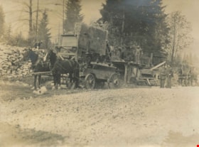
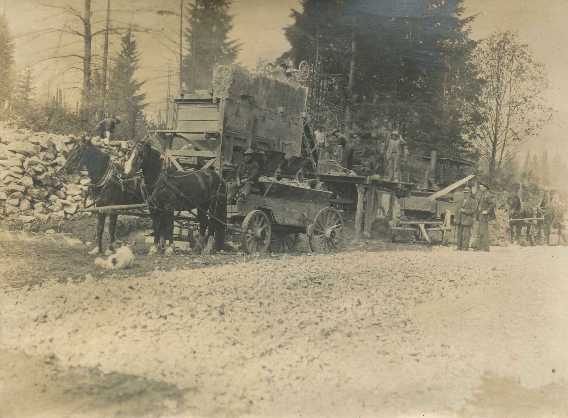
Rock crusher in operation
https://search.heritageburnaby.ca/link/archivedescription39573
- Repository
- City of Burnaby Archives
- Date
- August 1910
- Collection/Fonds
- Peers Family and Hill Family fonds
- Description Level
- Item
- Physical Description
- 1 photograph : b&w ; 7.5 x 10.2 cm on page 21.5 x 28 cm (pasted in album)
- Scope and Content
- Photograph of a rock crusher in operation. From a wall of rocks, a team of men puts the rock into the rock crusher. The crushed gravel is loaded up in a horse drawn cart, with a driver ready to transport it away. There are two men in suits to the right of the photograph watching the operation.
- Repository
- City of Burnaby Archives
- Date
- August 1910
- Collection/Fonds
- Peers Family and Hill Family fonds
- Physical Description
- 1 photograph : b&w ; 7.5 x 10.2 cm on page 21.5 x 28 cm (pasted in album)
- Description Level
- Item
- Record No.
- 477-892
- Access Restriction
- No restrictions
- Reproduction Restriction
- No known restrictions
- Accession Number
- 2007-12
- Scope and Content
- Photograph of a rock crusher in operation. From a wall of rocks, a team of men puts the rock into the rock crusher. The crushed gravel is loaded up in a horse drawn cart, with a driver ready to transport it away. There are two men in suits to the right of the photograph watching the operation.
- Names
- Oakalla Prison Farm
- Media Type
- Photograph
- Notes
- Title based on contents of photograph
- Geographic Access
- Oakmount Crescent
- Street Address
- 5220 Oakmount Crescent
- Historic Neighbourhood
- Burnaby Lake (Historic Neighbourhood)
- Planning Study Area
- Oakalla Area
Images
Excavating the basement
https://search.heritageburnaby.ca/link/archivedescription76899
- Repository
- City of Burnaby Archives
- Date
- 1946 (date of original), digitally copied 2012
- Collection/Fonds
- Community Heritage Commission Special Projects fonds
- Description Level
- Item
- Physical Description
- 1 photograph (jpeg) : col. ; 300ppi
- Scope and Content
- Photograph of the hand-dug excavation at Willingdon Avenue where Cice and Dennis Brown first erected their home.
- Repository
- City of Burnaby Archives
- Date
- 1946 (date of original), digitally copied 2012
- Collection/Fonds
- Community Heritage Commission Special Projects fonds
- Physical Description
- 1 photograph (jpeg) : col. ; 300ppi
- Description Level
- Item
- Record No.
- 549-019
- Access Restriction
- No restrictions
- Reproduction Restriction
- No known restrictions
- Accession Number
- 2012-30
- Scope and Content
- Photograph of the hand-dug excavation at Willingdon Avenue where Cice and Dennis Brown first erected their home.
- Media Type
- Photograph
- Notes
- Title based on contents of photograph
- Geographic Access
- Willingdon Avenue
- Historic Neighbourhood
- Central Park (Historic Neighbourhood)
- Planning Study Area
- Maywood Area
Images


Loading Strawberries, BCERy, Douglas Road, Burnaby BC
https://search.heritageburnaby.ca/link/archivedescription66211
- Repository
- City of Burnaby Archives
- Date
- 1894
- Collection/Fonds
- Peers Family and Hill Family fonds
- Description Level
- Item
- Physical Description
- 1 photograph : b&w ; 13 x 18 cm on cardboard 22 x 27.5 cm
- Scope and Content
- Photograph of a group of farmers loading their crates onto a railway car. Identified (left to right), Bernard R. Hill, Louis Claude Hill, Charles Frederick Sprott, George E. Clayton, and Louis "Edgar" Sprott, who are loading up their strawberries on a street car. The farmers are lined up in a row,…
- Repository
- City of Burnaby Archives
- Date
- 1894
- Collection/Fonds
- Peers Family and Hill Family fonds
- Physical Description
- 1 photograph : b&w ; 13 x 18 cm on cardboard 22 x 27.5 cm
- Description Level
- Item
- Record No.
- 477-938
- Access Restriction
- No restrictions
- Reproduction Restriction
- No known restrictions
- Accession Number
- 2007-12
- Scope and Content
- Photograph of a group of farmers loading their crates onto a railway car. Identified (left to right), Bernard R. Hill, Louis Claude Hill, Charles Frederick Sprott, George E. Clayton, and Louis "Edgar" Sprott, who are loading up their strawberries on a street car. The farmers are lined up in a row, each sitting in their own horse and cart as they bring their strawberries to the station.
- Subjects
- Agriculture - Fruit and Berries
- Transportation - Electric Railroads
- Transportation - Horses
- Transportation - Carts
- Occupations - Farmers
- Transportation - Wagons
- Officials - Mayors and Reeves
- Names
- British Columbia Electric Railway Company
- Hill, Louis Claude "Claude"
- Hill, Bernard R.
- Every-Clayton, George
- Sprott, Louis "Edgar"
- Sprott, Charles Frederick
- Media Type
- Photograph
- Notes
- Title based on contents of photograph
- Caption on recto of photograph reads: "Loading Strawberries, B.C.E.Ry., Douglas Rd., Burnaby, B.C."
- Geographic Access
- Douglas Road
- Historic Neighbourhood
- Burnaby Lake (Historic Neighbourhood)
Images

![Horse drawn wagon, [199_] thumbnail](/media/hpo/_Data/_BVM_Images/2020/2020_0005_0619_001.jpg?width=280)
Horse drawn wagon
https://search.heritageburnaby.ca/link/museumdescription12942
- Repository
- Burnaby Village Museum
- Date
- [199_]
- Collection/Fonds
- Burnaby Village Museum fonds
- Description Level
- Item
- Physical Description
- 1 photograph : col. ; 10 x 15 cm
- Scope and Content
- Photograph of a yellow wagon being driven by a man with a cowboy hat and pulled by two Belgian horses as visitors look on. They are heading down Hill Street inside Burnaby Village Museum. Children are getting rides in the wagon. A sign on the side of the wagon reads "Hillside Farms / Belgians / Map…
- Repository
- Burnaby Village Museum
- Collection/Fonds
- Burnaby Village Museum fonds
- Series
- Museum photographs series
- Description Level
- Item
- Physical Description
- 1 photograph : col. ; 10 x 15 cm
- Scope and Content
- Photograph of a yellow wagon being driven by a man with a cowboy hat and pulled by two Belgian horses as visitors look on. They are heading down Hill Street inside Burnaby Village Museum. Children are getting rides in the wagon. A sign on the side of the wagon reads "Hillside Farms / Belgians / Maple Ridge B.C...." The Village Trading Company and General Supply Store are visible on the right.
- Subjects
- Animals - Horses
- Transportation - Carriages
- Transportation - Horses
- Transportation - Wagons
- Names
- Burnaby Village Museum
- Accession Code
- BV020.5.619
- Access Restriction
- No restrictions
- Reproduction Restriction
- No known restrictions
- Date
- [199_]
- Media Type
- Photograph
- Scan Resolution
- 600
- Scan Date
- 9-Apr-20
- Scale
- 100
- Notes
- Title based on contents of photograph
Images
![Horse drawn wagon, [199_] thumbnail](/media/hpo/_Data/_BVM_Images/2020/2020_0005_0619_001.jpg)
1160 Douglas Rd
https://search.heritageburnaby.ca/link/archivedescription94327
- Repository
- City of Burnaby Archives
- Date
- December 1994
- Collection/Fonds
- Grover, Elliott & Co. Ltd. fonds
- Description Level
- File
- Physical Description
- 22 photographs : col. negatives ; 35 mm
- Scope and Content
- Photographs of the exterior of a three-storey commerical building located at 1160 Douglas Road.
- Repository
- City of Burnaby Archives
- Date
- December 1994
- Collection/Fonds
- Grover, Elliott & Co. Ltd. fonds
- Physical Description
- 22 photographs : col. negatives ; 35 mm
- Description Level
- File
- Record No.
- 622-112
- Access Restriction
- No restrictions
- Reproduction Restriction
- No restrictions
- Accession Number
- 2017-39
- Scope and Content
- Photographs of the exterior of a three-storey commerical building located at 1160 Douglas Road.
- Media Type
- Photograph
- Photographer
- Young, Richard
- Notes
- Transcribed title
- Title transcribed from envelope photographs were originally housed in
- File no. 94-424-B
- Geographic Access
- Douglas Road
- Street Address
- 1160 Douglas Road
- Historic Neighbourhood
- Vancouver Heights (Historic Neighbourhood)
- Planning Study Area
- Willingdon Heights Area
4010 Regent St.
https://search.heritageburnaby.ca/link/archivedescription94318
- Repository
- City of Burnaby Archives
- Date
- September 1994
- Collection/Fonds
- Grover, Elliott & Co. Ltd. fonds
- Description Level
- File
- Physical Description
- 25 photographs : col. negatives ; 35 mm
- Scope and Content
- Photographs of an undeveloped property located at 4010 Regent Street. Property is covered with soil, brush, and some trees.
- Repository
- City of Burnaby Archives
- Date
- September 1994
- Collection/Fonds
- Grover, Elliott & Co. Ltd. fonds
- Physical Description
- 25 photographs : col. negatives ; 35 mm
- Description Level
- File
- Record No.
- 622-103
- Access Restriction
- No restrictions
- Reproduction Restriction
- No restrictions
- Accession Number
- 2017-39
- Scope and Content
- Photographs of an undeveloped property located at 4010 Regent Street. Property is covered with soil, brush, and some trees.
- Subjects
- Land Clearing
- Media Type
- Photograph
- Photographer
- Young, Richard
- Notes
- Transcribed title
- Title transcribed from envelope photographs were originally housed in
- File no. 94-342-B
- Geographic Access
- Regent Street
- Street Address
- 4010 Regent Street
- Historic Neighbourhood
- Broadview (Historic Neighbourhood)
- Planning Study Area
- West Central Valley Area
5200 Oakmount Cr.
https://search.heritageburnaby.ca/link/archivedescription94313
- Repository
- City of Burnaby Archives
- Date
- June 1994
- Collection/Fonds
- Grover, Elliott & Co. Ltd. fonds
- Description Level
- File
- Physical Description
- 23 photographs : col. negatives ; 35 mm
- Scope and Content
- Photographs of an undeveloped property located at 5200 Oakmount Crescent - an address that no longer exists.
- Repository
- City of Burnaby Archives
- Date
- June 1994
- Collection/Fonds
- Grover, Elliott & Co. Ltd. fonds
- Physical Description
- 23 photographs : col. negatives ; 35 mm
- Description Level
- File
- Record No.
- 622-098
- Access Restriction
- No restrictions
- Reproduction Restriction
- No restrictions
- Accession Number
- 2017-39
- Scope and Content
- Photographs of an undeveloped property located at 5200 Oakmount Crescent - an address that no longer exists.
- Subjects
- Land Clearing
- Media Type
- Photograph
- Notes
- Transcribed title
- Title transcribed from envelope photographs were originally housed in
- File no. 94-236-B
- Photographer identified as "J.C."
- Geographic Access
- Oakmount Crescent
- Historic Neighbourhood
- Central Park (Historic Neighbourhood)
- Planning Study Area
- Windsor Area
5548 Marshland Ave
https://search.heritageburnaby.ca/link/archivedescription94302
- Repository
- City of Burnaby Archives
- Date
- January 1994
- Collection/Fonds
- Grover, Elliott & Co. Ltd. fonds
- Description Level
- File
- Physical Description
- 25 photographs : col. negatives ; 35 mm
- Scope and Content
- Photographs of an undeveloped property located at 5548 Marshland Avenue - an address that no longer exists.
- Repository
- City of Burnaby Archives
- Date
- January 1994
- Collection/Fonds
- Grover, Elliott & Co. Ltd. fonds
- Physical Description
- 25 photographs : col. negatives ; 35 mm
- Description Level
- File
- Record No.
- 622-087
- Access Restriction
- No restrictions
- Reproduction Restriction
- No restrictions
- Accession Number
- 2017-39
- Scope and Content
- Photographs of an undeveloped property located at 5548 Marshland Avenue - an address that no longer exists.
- Subjects
- Land Clearing
- Media Type
- Photograph
- Notes
- Transcribed title
- Title transcribed from envelope photographs were originally housed in
- File no. 94-023-B
- Photographer identified as "K.D."
- Geographic Access
- Marshland Avenue
- Historic Neighbourhood
- Fraser Arm (Historic Neighbourhood)
- Planning Study Area
- Big Bend Area

6113 Silver Avenue lot
https://search.heritageburnaby.ca/link/archivedescription37775
- Repository
- City of Burnaby Archives
- Date
- 1986 (date of original), copied 1991
- Collection/Fonds
- Burnaby Historical Society fonds
- Description Level
- Item
- Physical Description
- 1 photograph : b&w ; 3.1 x 4.4 cm print on contact sheet 20.3 x 26.2 cm
- Scope and Content
- Photograph of the lot at 6113 Silver Avenue, the former home of the Ellis family. The house has been demolished and an empty lot remains. Houses, aparment buildings, and the Expo line skytrain track with cars on it can be seen in the background.
- Repository
- City of Burnaby Archives
- Date
- 1986 (date of original), copied 1991
- Collection/Fonds
- Burnaby Historical Society fonds
- Subseries
- Burnaby Image Bank subseries
- Physical Description
- 1 photograph : b&w ; 3.1 x 4.4 cm print on contact sheet 20.3 x 26.2 cm
- Description Level
- Item
- Record No.
- 370-363
- Access Restriction
- No restrictions
- Reproduction Restriction
- No restrictions
- Accession Number
- BHS1999-03
- Scope and Content
- Photograph of the lot at 6113 Silver Avenue, the former home of the Ellis family. The house has been demolished and an empty lot remains. Houses, aparment buildings, and the Expo line skytrain track with cars on it can be seen in the background.
- Subjects
- Land Clearing
- Media Type
- Photograph
- Notes
- Title based on contents of photograph
- 1 b&w copy negative accompanying
- Negative has a pink cast
- Copied from col. photograph
- Geographic Access
- Silver Avenue
- Street Address
- 6113 Silver Avenue
- Historic Neighbourhood
- Central Park (Historic Neighbourhood)
- Planning Study Area
- Maywood Area
Images

7026 Kingsway
https://search.heritageburnaby.ca/link/archivedescription94304
- Repository
- City of Burnaby Archives
- Date
- January 1994
- Collection/Fonds
- Grover, Elliott & Co. Ltd. fonds
- Description Level
- File
- Physical Description
- 19 photographs : col. negatives ; 35 mm
- Scope and Content
- Photographs of commercial and undeveloped properties located in the 7100 block of Kingsway, including Middlegate Honda, with mid-rise towers visible in the background.
- Repository
- City of Burnaby Archives
- Date
- January 1994
- Collection/Fonds
- Grover, Elliott & Co. Ltd. fonds
- Physical Description
- 19 photographs : col. negatives ; 35 mm
- Description Level
- File
- Record No.
- 622-089
- Access Restriction
- No restrictions
- Reproduction Restriction
- No restrictions
- Accession Number
- 2017-39
- Scope and Content
- Photographs of commercial and undeveloped properties located in the 7100 block of Kingsway, including Middlegate Honda, with mid-rise towers visible in the background.
- Media Type
- Photograph
- Notes
- Transcribed title
- Title transcribed from envelope photographs were originally housed in
- File no. 94-028-B
- Photographer identified as "L.D."
- Geographic Access
- Kingsway
- Historic Neighbourhood
- Edmonds (Historic Neighbourhood)
- Planning Study Area
- Stride Avenue Area
8855 Northbrook Court
https://search.heritageburnaby.ca/link/archivedescription93735
- Repository
- City of Burnaby Archives
- Date
- 1989
- Collection/Fonds
- Grover, Elliott & Co. Ltd. fonds
- Description Level
- File
- Physical Description
- 21 photographs : col. negatives ; 35 mm
- Scope and Content
- Photographs of an undeveloped property loacated at 8855 Northbrook Court. Construction equipment is visible in the distance.
- Repository
- City of Burnaby Archives
- Date
- 1989
- Collection/Fonds
- Grover, Elliott & Co. Ltd. fonds
- Physical Description
- 21 photographs : col. negatives ; 35 mm
- Description Level
- File
- Record No.
- 622-020
- Access Restriction
- No restrictions
- Reproduction Restriction
- No restrictions
- Accession Number
- 2017-39
- Scope and Content
- Photographs of an undeveloped property loacated at 8855 Northbrook Court. Construction equipment is visible in the distance.
- Media Type
- Photograph
- Notes
- Transcribed title
- Title transcribed from original print envelope
- File no. 89-037-B
- Geographic Access
- Northbrook Court
- Street Address
- 8855 Northbrook Court
- Historic Neighbourhood
- Fraser Arm (Historic Neighbourhood)
- Planning Study Area
- Big Bend Area
8980 Fraserwood Crt
https://search.heritageburnaby.ca/link/archivedescription94326
- Repository
- City of Burnaby Archives
- Date
- December 1994
- Collection/Fonds
- Grover, Elliott & Co. Ltd. fonds
- Description Level
- File
- Physical Description
- 24 photographs : col. negatives ; 35 mm
- Scope and Content
- Photographs of an undeveloped property located at 8980 Fraserwood Court. A Sutton Group real estate sign on the property advertises the site as the Fraserwood Corporate Centre with strata warehouse and office flex space. File also contains photographs of the commerical building adjacent to the si…
- Repository
- City of Burnaby Archives
- Date
- December 1994
- Collection/Fonds
- Grover, Elliott & Co. Ltd. fonds
- Physical Description
- 24 photographs : col. negatives ; 35 mm
- Description Level
- File
- Record No.
- 622-111
- Access Restriction
- No restrictions
- Reproduction Restriction
- No restrictions
- Accession Number
- 2017-39
- Scope and Content
- Photographs of an undeveloped property located at 8980 Fraserwood Court. A Sutton Group real estate sign on the property advertises the site as the Fraserwood Corporate Centre with strata warehouse and office flex space. File also contains photographs of the commerical building adjacent to the site.
- Media Type
- Photograph
- Notes
- Transcribed title
- Title transcribed from envelope photographs were originally housed in
- File no. 94-422-B
- Photographer identified as "L.D."
- Geographic Access
- Fraserwood Court
- Street Address
- 8980 Fraserwood Court
- Historic Neighbourhood
- Fraser Arm (Historic Neighbourhood)
- Planning Study Area
- Big Bend Area
![Ada Bingham by a tree stump, [1948] thumbnail](/media/hpo/_Data/_BVM_Images/1976/1976_0046_0005_001.jpg?width=280)
Ada Bingham by a tree stump
https://search.heritageburnaby.ca/link/museumdescription739
- Repository
- Burnaby Village Museum
- Date
- [1948]
- Collection/Fonds
- Burnaby Village Museum Photograph collection
- Description Level
- Item
- Physical Description
- 1 photograph : b&w ; 11.3 x 6.8 cm
- Scope and Content
- Photograph of Mary Ada Bingham standing in front of a giant tree stump in Willingdon Heights which was to be cleared for a veterans' housing project in 1948. According to an accompanying note prepared by Burnaby Village Museum, and supported by the inscription on the photograph, Ada Bingham came to…
- Repository
- Burnaby Village Museum
- Collection/Fonds
- Burnaby Village Museum Photograph collection
- Description Level
- Item
- Physical Description
- 1 photograph : b&w ; 11.3 x 6.8 cm
- Material Details
- Inscribed in black ballpoint pen, on the back of the photo: "Ada and Big Stump / Clearing time on Willingdon Heights / 1948. / Burnaby 2. B. C" and in blue ballpoint pen: "Mrs. Mary Ada Bingham / 1 Real Pioneer Wife; she helped me clear the land. Build our home, dig out well and worked for the community for nearly 50 years. She died August 9, 1969 / Alf Bingham."
- Scope and Content
- Photograph of Mary Ada Bingham standing in front of a giant tree stump in Willingdon Heights which was to be cleared for a veterans' housing project in 1948. According to an accompanying note prepared by Burnaby Village Museum, and supported by the inscription on the photograph, Ada Bingham came to Burnaby to homestead with her husband, Alfred "Alf" Bingham, in 1919. They settled in the Lochdale district of North Burnaby but later moved to Parker Street.
- Subjects
- Land Clearing
- Plants - Trees
- Names
- Bingham, Mary Ada "Ada"
- Accession Code
- HV976.46.5
- Access Restriction
- No restrictions
- Reproduction Restriction
- No known restrictions
- Date
- [1948]
- Media Type
- Photograph
- Historic Neighbourhood
- Vancouver Heights (Historic Neighbourhood)
- Planning Study Area
- Willingdon Heights Area
- Scan Resolution
- 600
- Scan Date
- 2023-06-20
- Notes
- Title based on contents of photograph
Images
![Ada Bingham by a tree stump, [1948] thumbnail](/media/hpo/_Data/_BVM_Images/1976/1976_0046_0005_001.jpg)
Aerial photograph of Burnaby Mountain
https://search.heritageburnaby.ca/link/archivedescription64460
- Repository
- City of Burnaby Archives
- Date
- [1957 or 1958]
- Collection/Fonds
- Burnaby Historical Society fonds
- Description Level
- Item
- Physical Description
- 1 photograph : b&w ; 14 x 14 cm
- Scope and Content
- Aerial photograph of the Burnaby Mountain park and Centennial Pavilion, under construction.
- Repository
- City of Burnaby Archives
- Date
- [1957 or 1958]
- Collection/Fonds
- Burnaby Historical Society fonds
- Subseries
- North Burnaby Board of Trade subseries
- Physical Description
- 1 photograph : b&w ; 14 x 14 cm
- Description Level
- Item
- Record No.
- 476-026
- Access Restriction
- No restrictions
- Reproduction Restriction
- Reproduce for fair dealing purposes only
- Accession Number
- BHS2005-8
- Scope and Content
- Aerial photograph of the Burnaby Mountain park and Centennial Pavilion, under construction.
- Subjects
- Aerial Photographs
- Land Clearing
- Media Type
- Photograph
- Photographer
- Hunting Survey Corporation Limited
- Notes
- Title based on contents of photograph
- Geographic Access
- Burnaby Mountain Conservation Area
- Centennial Way
- Street Address
- 100 Centennial Way
- Planning Study Area
- Burnaby Mountain Area
![Aerial photograph of Burnaby Mountain, [1957 or 1958] thumbnail](/media/hpo/_Data/_Archives_Images/_Unrestricted/371/476-025.jpg?width=280)
Aerial photograph of Burnaby Mountain
https://search.heritageburnaby.ca/link/archivedescription39742
- Repository
- City of Burnaby Archives
- Date
- [1957 or 1958]
- Collection/Fonds
- Burnaby Historical Society fonds
- Description Level
- Item
- Physical Description
- 1 photograph : b&w ; 14 x 14 cm
- Scope and Content
- Aerial photograph of the Burnaby Mountain park and Centennial Pavilion, under construction.
- Repository
- City of Burnaby Archives
- Date
- [1957 or 1958]
- Collection/Fonds
- Burnaby Historical Society fonds
- Subseries
- North Burnaby Board of Trade subseries
- Physical Description
- 1 photograph : b&w ; 14 x 14 cm
- Description Level
- Item
- Record No.
- 476-025
- Access Restriction
- No restrictions
- Reproduction Restriction
- Reproduce for fair dealing purposes only
- Accession Number
- BHS2005-8
- Scope and Content
- Aerial photograph of the Burnaby Mountain park and Centennial Pavilion, under construction.
- Subjects
- Aerial Photographs
- Land Clearing
- Media Type
- Photograph
- Photographer
- Hunting Survey Corporation Limited
- Notes
- Title based on contents of photograph.
- Geographic Access
- Burnaby Mountain Conservation Area
- Centennial Way
- Street Address
- 100 Centennial Way
- Planning Study Area
- Burnaby Mountain Area
Images
![Aerial photograph of Burnaby Mountain, [1957 or 1958] thumbnail](/media/hpo/_Data/_Archives_Images/_Unrestricted/371/476-025.jpg)

Alfred Bingham
https://search.heritageburnaby.ca/link/archivedescription34149
- Repository
- City of Burnaby Archives
- Date
- April 20, 1947
- Collection/Fonds
- Burnaby Historical Society fonds
- Description Level
- Item
- Physical Description
- 1 photograph : b&w negative ; 11.3 x 6.8 cm
- Scope and Content
- Photograph of Alfred "Alf" Bingham standing in front of a fir tree stump that is approximately 400 years old on the 4200 block of Kitchener Street. This is part of the Willingdon Heights subdivision site.
- Repository
- City of Burnaby Archives
- Date
- April 20, 1947
- Collection/Fonds
- Burnaby Historical Society fonds
- Subseries
- Alfred Bingham subseries
- Physical Description
- 1 photograph : b&w negative ; 11.3 x 6.8 cm
- Description Level
- Item
- Record No.
- 010-066
- Access Restriction
- No restrictions
- Reproduction Restriction
- Reproduce for fair dealing purposes only
- Accession Number
- BHS2007-04
- Scope and Content
- Photograph of Alfred "Alf" Bingham standing in front of a fir tree stump that is approximately 400 years old on the 4200 block of Kitchener Street. This is part of the Willingdon Heights subdivision site.
- Subjects
- Land Clearing
- Plants - Trees
- Names
- Bingham, Alfred "Alf"
- Media Type
- Photograph
- Photographer
- Bingham, Alfred "Alf"
- Notes
- Title based on contents of photograph
- Geographic Access
- Kitchener Street
Images


Allanson family clearing land
https://search.heritageburnaby.ca/link/archivedescription35793
- Repository
- City of Burnaby Archives
- Date
- 1923 (date of original), copied 1986
- Collection/Fonds
- Burnaby Historical Society fonds
- Description Level
- Item
- Physical Description
- 1 photograph : b&w ; 12.7 x 17.8 cm print
- Scope and Content
- Photograph of the Allanson family clearing the land at 12 Warwick Avenue bought by Malcolm and Mabel Allanson. Left to right: William Allanson, Mabel Allanson, Malcolm Allanson, and Jessie Allanson. William and Jessie Allanson are the parents of Malcolm. Mabel and Malcolm Allanson are married.
- Repository
- City of Burnaby Archives
- Date
- 1923 (date of original), copied 1986
- Collection/Fonds
- Burnaby Historical Society fonds
- Subseries
- Pioneer Tales subseries
- Physical Description
- 1 photograph : b&w ; 12.7 x 17.8 cm print
- Description Level
- Item
- Record No.
- 204-651
- Access Restriction
- No restrictions
- Reproduction Restriction
- No known restrictions
- Accession Number
- BHS1988-03
- Scope and Content
- Photograph of the Allanson family clearing the land at 12 Warwick Avenue bought by Malcolm and Mabel Allanson. Left to right: William Allanson, Mabel Allanson, Malcolm Allanson, and Jessie Allanson. William and Jessie Allanson are the parents of Malcolm. Mabel and Malcolm Allanson are married.
- Subjects
- Land Clearing
- Plants - Trees
- Media Type
- Photograph
- Notes
- Title based on contents of photograph
- Geographic Access
- Warwick Avenue
- Street Address
- 12 Warwick Avenue
- Historic Neighbourhood
- Capitol Hill (Historic Neighbourhood)
- Planning Study Area
- Capitol Hill Area
Images

![Alpha Avenue and Union Street, [194-] thumbnail](/media/hpo/_Data/_Archives_Images/_Unrestricted/126/154-003.jpg?width=280)
Alpha Avenue and Union Street
https://search.heritageburnaby.ca/link/archivedescription34887
- Repository
- City of Burnaby Archives
- Date
- [194-]
- Collection/Fonds
- Burnaby Historical Society fonds
- Description Level
- Item
- Physical Description
- 1 photograph : b&w ; 7.0 x 11.4 cm
- Scope and Content
- Photograph of two children beside a sandbox at Alpha Avenue and Union Street. Stumps can be seen in the background. An annotation on the back of the photograph reads, "The Alpha School is built on the property."
- Repository
- City of Burnaby Archives
- Date
- [194-]
- Collection/Fonds
- Burnaby Historical Society fonds
- Subseries
- Olive Cullum subseries
- Physical Description
- 1 photograph : b&w ; 7.0 x 11.4 cm
- Material Details
- Printed on photo paper: "Selo"
- Description Level
- Item
- Record No.
- 154-003
- Access Restriction
- No restrictions
- Reproduction Restriction
- Reproduce for fair dealing purposes only
- Accession Number
- BHS1985-27
- Scope and Content
- Photograph of two children beside a sandbox at Alpha Avenue and Union Street. Stumps can be seen in the background. An annotation on the back of the photograph reads, "The Alpha School is built on the property."
- Subjects
- Land Clearing
- Toys
- Media Type
- Photograph
- Notes
- Title based on contents of photograph
- Stamped on back of photo: "017"
- Geographic Access
- Alpha Avenue
- Union Street
- Planning Study Area
- Brentwood Area
Images
![Alpha Avenue and Union Street, [194-] thumbnail](/media/hpo/_Data/_Archives_Images/_Unrestricted/126/154-003.jpg)