More like 'The Lions from Burnaby Park'
Narrow Results By
Subject
- Accidents - Automobile Accidents 1
- Advertising Medium - Signs and Signboards 20
- Aerial Photographs 34
- Agricultural Tools and Equipment 2
- Agricultural Tools and Equipment - Gardening Equipment 4
- Agricultural Tools and Equipment - Plows 2
- Agriculture 2
- Agriculture - Farms 10
- Agriculture - Fruit and Berries 2
- Animals 4
- Animals - Bears 2
- Animals - Birds 28
![Looking east from 410 North Hythe, [1930] thumbnail](/media/hpo/_Data/_Archives_Images/_Unrestricted/371/443-006.jpg?width=280)
Looking east from 410 North Hythe
https://search.heritageburnaby.ca/link/archivedescription38439
- Repository
- City of Burnaby Archives
- Date
- [1930]
- Collection/Fonds
- Burnaby Historical Society fonds
- Description Level
- Item
- Physical Description
- 1 photograph : b&w ; 6.3 x 9 cm
- Scope and Content
- Photograph looking east from 410 North Hythe Avenue along Burrard Inlet.
- Repository
- City of Burnaby Archives
- Date
- [1930]
- Collection/Fonds
- Burnaby Historical Society fonds
- Subseries
- Photographs subseries
- Physical Description
- 1 photograph : b&w ; 6.3 x 9 cm
- Description Level
- Item
- Record No.
- 443-006
- Access Restriction
- No restrictions
- Reproduction Restriction
- No known restrictions
- Accession Number
- BHS2002-13
- Scope and Content
- Photograph looking east from 410 North Hythe Avenue along Burrard Inlet.
- Media Type
- Photograph
- Notes
- Title based on contents of photograph.
- Geographic Access
- Hythe Avenue North
- Street Address
- 410 Hythe Avenue North
- Historic Neighbourhood
- Capitol Hill (Historic Neighbourhood)
- Planning Study Area
- Capitol Hill Area
Images
![Looking east from 410 North Hythe, [1930] thumbnail](/media/hpo/_Data/_Archives_Images/_Unrestricted/371/443-006.jpg)
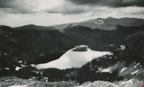
Moat Lake
https://search.heritageburnaby.ca/link/archivedescription51451
- Repository
- City of Burnaby Archives
- Date
- 1938
- Collection/Fonds
- Burnaby Historical Society fonds
- Description Level
- Item
- Physical Description
- 1 photograph : b&w postcard ; 13 x 8 cm, mounted on heavy-weight paper 17.5 x 26.5 cm
- Scope and Content
- Photographic postcard of Moat Lake nestled among the mountains of the Forbidden Plateau on Vancouver Island. This was part of a trip made by a small party of City of Courtenay officials. George A. Grant was one of the climbers in the party.
- Repository
- City of Burnaby Archives
- Date
- 1938
- Collection/Fonds
- Burnaby Historical Society fonds
- Subseries
- George Grant subseries
- Physical Description
- 1 photograph : b&w postcard ; 13 x 8 cm, mounted on heavy-weight paper 17.5 x 26.5 cm
- Description Level
- Item
- Record No.
- 243-056
- Access Restriction
- No restrictions
- Reproduction Restriction
- No known restrictions
- Accession Number
- BHS1990-06
- Scope and Content
- Photographic postcard of Moat Lake nestled among the mountains of the Forbidden Plateau on Vancouver Island. This was part of a trip made by a small party of City of Courtenay officials. George A. Grant was one of the climbers in the party.
- Media Type
- Photograph
- Photographer
- Tait, Preston L.
- Notes
- Title taken from handwritten title on paper mount
- Handwritten note on facing page reads: "So shall thy wondering sight at once survey / Vales, lakes, woods, mountains, islands, rocks and sea / Huge hills that heaped in crowded order stand / Stretched o'er the northern and the western land / Thomas Russell"
- Photographer identifies photograph as no. 835
Images

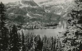
Moat Lake as viewed on Mt. Albert Edward climb
https://search.heritageburnaby.ca/link/archivedescription51452
- Repository
- City of Burnaby Archives
- Date
- 1938
- Collection/Fonds
- Burnaby Historical Society fonds
- Description Level
- Item
- Physical Description
- 1 photograph : b&w postcard ; 8 x 13 cm, mounted on heavy-weight paper 17.5 x 26.5 cm
- Scope and Content
- Photographic postcard of Moat lake, taken from Mount Albert Edward. This was part of a trip to the Forbidden Plateau on Vancouver Island made by a small party of City of Courtenay officials. George A. Grant was one of the climbers in the party.
- Repository
- City of Burnaby Archives
- Date
- 1938
- Collection/Fonds
- Burnaby Historical Society fonds
- Subseries
- George Grant subseries
- Physical Description
- 1 photograph : b&w postcard ; 8 x 13 cm, mounted on heavy-weight paper 17.5 x 26.5 cm
- Description Level
- Item
- Record No.
- 243-057
- Access Restriction
- No restrictions
- Reproduction Restriction
- No known restrictions
- Accession Number
- BHS1990-06
- Scope and Content
- Photographic postcard of Moat lake, taken from Mount Albert Edward. This was part of a trip to the Forbidden Plateau on Vancouver Island made by a small party of City of Courtenay officials. George A. Grant was one of the climbers in the party.
- Media Type
- Photograph
- Photographer
- Tait, Preston L.
- Notes
- Title taken from handwritten title on paper mount
- Handwritten note on facing page reads: "Lovest thou mountains great / Peaks to the clouds that soar / Corrie and fell where eagles dwell / And cataracts dash evermore ? / Sheriff Nicholson"
Images

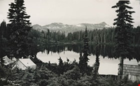
Mount Albert Edward
https://search.heritageburnaby.ca/link/archivedescription36316
- Repository
- City of Burnaby Archives
- Date
- 1938
- Collection/Fonds
- Burnaby Historical Society fonds
- Description Level
- Item
- Physical Description
- 1 photograph : b&w postcard ; 13 x 8 cm, mounted on heavy-weight paper 17.5 x 26.5 cm
- Scope and Content
- Photographic postcard of Mount Albert Edward at 6871 feet, taken from Croteau Lake. This was part of a trip to the Forbidden Plateau on Vancouver Island made by a small party of City of Courtenay officials. George A. Grant was one of the climbers in the party.
- Repository
- City of Burnaby Archives
- Date
- 1938
- Collection/Fonds
- Burnaby Historical Society fonds
- Subseries
- George Grant subseries
- Physical Description
- 1 photograph : b&w postcard ; 13 x 8 cm, mounted on heavy-weight paper 17.5 x 26.5 cm
- Description Level
- Item
- Record No.
- 243-049
- Access Restriction
- No restrictions
- Reproduction Restriction
- No known restrictions
- Accession Number
- BHS1990-06
- Scope and Content
- Photographic postcard of Mount Albert Edward at 6871 feet, taken from Croteau Lake. This was part of a trip to the Forbidden Plateau on Vancouver Island made by a small party of City of Courtenay officials. George A. Grant was one of the climbers in the party.
- Media Type
- Photograph
- Photographer
- Tait, Preston L.
- Notes
- Title taken from handwritten title on paper mount
- Handwritten note on accompanying page reads: "The Castle hath a pleasant seat / Shakespeare"
- Photographer identifies photograph as no. 764
Images


Road round 1st tunnel
https://search.heritageburnaby.ca/link/archivedescription34407
- Repository
- City of Burnaby Archives
- Date
- 1925
- Collection/Fonds
- Burnaby Historical Society fonds
- Description Level
- Item
- Physical Description
- 1 photograph : b&w ; 7 x 12.2 cm on page 17.5 x 26.5 cm
- Scope and Content
- Photographs taken in Yale, looking toward a tunnel cut through a rock face at the side of a mountain. A caption written under the photograph reads "road round [sic] 1st tunnel." This photograph appears to have been taken by Arthur Peers, who travelled through the Fraser River Valley and worked on …
- Repository
- City of Burnaby Archives
- Date
- 1925
- Collection/Fonds
- Burnaby Historical Society fonds
- Subseries
- Peers family subseries
- Physical Description
- 1 photograph : b&w ; 7 x 12.2 cm on page 17.5 x 26.5 cm
- Description Level
- Item
- Record No.
- 020-114
- Access Restriction
- No restrictions
- Reproduction Restriction
- No known restrictions
- Accession Number
- BHS2007-04
- Scope and Content
- Photographs taken in Yale, looking toward a tunnel cut through a rock face at the side of a mountain. A caption written under the photograph reads "road round [sic] 1st tunnel." This photograph appears to have been taken by Arthur Peers, who travelled through the Fraser River Valley and worked on the construction of the Trans-Provincial Highway during the later 1920s.
- Media Type
- Photograph
- Photographer
- Peers, Arthur Francis "Mike"
- Notes
- Title based on caption accompanying photograph
Images

![Rower on Burnaby Lake, [2004] thumbnail](/media/hpo/_Data/_Archives_Images/_Unrestricted/535/535-1798.jpg?width=280)
Rower on Burnaby Lake
https://search.heritageburnaby.ca/link/archivedescription96049
- Repository
- City of Burnaby Archives
- Date
- [2004]
- Collection/Fonds
- Burnaby NewsLeader photograph collection
- Description Level
- Item
- Physical Description
- 1 photograph (tiff) : col.
- Scope and Content
- Photograph of a single rower on Burnaby Lake. The snow-covered North Shore mountains are visible in the background.
- Repository
- City of Burnaby Archives
- Date
- [2004]
- Collection/Fonds
- Burnaby NewsLeader photograph collection
- Physical Description
- 1 photograph (tiff) : col.
- Description Level
- Item
- Record No.
- 535-1798
- Access Restriction
- No restrictions
- Reproduction Restriction
- No restrictions
- Accession Number
- 2018-12
- Scope and Content
- Photograph of a single rower on Burnaby Lake. The snow-covered North Shore mountains are visible in the background.
- Subjects
- Recreational Activities - Boating
- Geographic Features - Lakes and Ponds
- Geographic Features - Mountains
- Media Type
- Photograph
- Photographer
- Bartel, Mario
- Notes
- Title based on caption
- Collected by editorial for use in a February 2004 issue of the Burnaby NewsLeader
- Caption from metadata: "A rower heading out into Burnaby Lake Saturday for a morning workout is dwarfed by the majestic North Shore mountains."
- Geographic Access
- Burnaby Lake Regional Nature Park
- Burnaby Lake
- Historic Neighbourhood
- Burnaby Lake (Historic Neighbourhood)
- Planning Study Area
- Burnaby Lake Area
Images
![Rower on Burnaby Lake, [2004] thumbnail](/media/hpo/_Data/_Archives_Images/_Unrestricted/535/535-1798.jpg)
![Unidentified mountain range and river, [1880] thumbnail](/media/hpo/_Data/_Archives_Images/_Unrestricted/477/477-824.jpg?width=280)
Unidentified mountain range and river
https://search.heritageburnaby.ca/link/archivedescription39505
- Repository
- City of Burnaby Archives
- Date
- [1880]
- Collection/Fonds
- Peers Family and Hill Family fonds
- Description Level
- Item
- Physical Description
- 1 photograph : sepia ; 11.3 x 17.5 cm on page 21.5 x 28 cm (pasted in album)
- Scope and Content
- Photograph of a person sitting on a hillside, looking off into the distance at an unidentified mountain range and river. This photograph was in a scrapbook kept by Claude Hill who was originally from England but ultimately settled in the Burnaby Lake area. The photograph was likely taken in England…
- Repository
- City of Burnaby Archives
- Date
- [1880]
- Collection/Fonds
- Peers Family and Hill Family fonds
- Physical Description
- 1 photograph : sepia ; 11.3 x 17.5 cm on page 21.5 x 28 cm (pasted in album)
- Description Level
- Item
- Record No.
- 477-824
- Access Restriction
- No restrictions
- Reproduction Restriction
- No known restrictions
- Accession Number
- 2007-12
- Scope and Content
- Photograph of a person sitting on a hillside, looking off into the distance at an unidentified mountain range and river. This photograph was in a scrapbook kept by Claude Hill who was originally from England but ultimately settled in the Burnaby Lake area. The photograph was likely taken in England or Wales.
- Media Type
- Photograph
- Notes
- Title based on contents of photograph
Images
![Unidentified mountain range and river, [1880] thumbnail](/media/hpo/_Data/_Archives_Images/_Unrestricted/477/477-824.jpg)

View from Kask's Camp
https://search.heritageburnaby.ca/link/archivedescription35531
- Repository
- City of Burnaby Archives
- Date
- 1950 (date of original), copied 1986
- Collection/Fonds
- Burnaby Historical Society fonds
- Description Level
- Item
- Physical Description
- 1 photograph : b&w ; 12.7 x 17.8 cm print
- Scope and Content
- Photograph of top of the hill moved by William Kask, Sr. at the request of Jenny Korhonen Kask who wanted a better view of Burrard Inlet and the islands from her house in Kask's Camp, later Kask Bros. Cement Works. Mr. Kask had the top of the mountain shave off with a bulldozer. A Vancouver Sun h…
- Repository
- City of Burnaby Archives
- Date
- 1950 (date of original), copied 1986
- Collection/Fonds
- Burnaby Historical Society fonds
- Subseries
- Pioneer Tales subseries
- Physical Description
- 1 photograph : b&w ; 12.7 x 17.8 cm print
- Description Level
- Item
- Record No.
- 204-389
- Access Restriction
- No restrictions
- Reproduction Restriction
- Reproduce for fair dealing purposes only
- Accession Number
- BHS1988-03
- Scope and Content
- Photograph of top of the hill moved by William Kask, Sr. at the request of Jenny Korhonen Kask who wanted a better view of Burrard Inlet and the islands from her house in Kask's Camp, later Kask Bros. Cement Works. Mr. Kask had the top of the mountain shave off with a bulldozer. A Vancouver Sun headline read, "Man Moves Mountain."
- Media Type
- Photograph
- Notes
- Title based on contents of photograph
- Geographic Access
- Barnet Road
- Street Address
- 7501 Barnet Road
- Historic Neighbourhood
- Barnet (Historic Neighbourhood)
- Planning Study Area
- Burnaby Mountain Area
Images

![Yale, BC, [1925] thumbnail](/media/hpo/_Data/_Archives_Images/_Unrestricted/001/020-076.jpg?width=280)
Yale, BC
https://search.heritageburnaby.ca/link/archivedescription34369
- Repository
- City of Burnaby Archives
- Date
- [1925]
- Collection/Fonds
- Burnaby Historical Society fonds
- Description Level
- Item
- Physical Description
- 1 photograph : sepia ; 7 x 11.6 cm on page 17.5 x 26.4 cm
- Scope and Content
- Photograph of railway tracks along a river at a location identified as Yale, B.C. This photograph appears to have been taken by Arthur Peers, who travelled through the Fraser River Valley and worked on the construction of the Trans-Provincial Highway during the later 1920s.
- Repository
- City of Burnaby Archives
- Date
- [1925]
- Collection/Fonds
- Burnaby Historical Society fonds
- Subseries
- Peers family subseries
- Physical Description
- 1 photograph : sepia ; 7 x 11.6 cm on page 17.5 x 26.4 cm
- Description Level
- Item
- Record No.
- 020-076
- Access Restriction
- No restrictions
- Reproduction Restriction
- No known restrictions
- Accession Number
- BHS2007-04
- Scope and Content
- Photograph of railway tracks along a river at a location identified as Yale, B.C. This photograph appears to have been taken by Arthur Peers, who travelled through the Fraser River Valley and worked on the construction of the Trans-Provincial Highway during the later 1920s.
- Media Type
- Photograph
- Photographer
- Peers, Arthur Francis "Mike"
- Notes
- Title based on caption accompanying photograph
Images
![Yale, BC, [1925] thumbnail](/media/hpo/_Data/_Archives_Images/_Unrestricted/001/020-076.jpg)
7837 CA Way Burnaby
https://search.heritageburnaby.ca/link/archivedescription93813
- Repository
- City of Burnaby Archives
- Date
- November 1992
- Collection/Fonds
- Grover, Elliott & Co. Ltd. fonds
- Description Level
- File
- Physical Description
- 48 photographs : col. negatives ; 35 mm + 5 photographs : col. ; 10 cm x 15 cm
- Scope and Content
- Photographs of the residential buildings located at 7837 Canada Way. Buildings include a two-storey blue-shingled house, single-storey addition, and a guest house. File also contains photographs of the Capilano suspension bridge and Capilano Suspension Bridge Park in North Vancouver.
- Repository
- City of Burnaby Archives
- Date
- November 1992
- Collection/Fonds
- Grover, Elliott & Co. Ltd. fonds
- Physical Description
- 48 photographs : col. negatives ; 35 mm + 5 photographs : col. ; 10 cm x 15 cm
- Description Level
- File
- Record No.
- 622-061
- Access Restriction
- No restrictions
- Reproduction Restriction
- No restrictions
- Accession Number
- 2017-39
- Scope and Content
- Photographs of the residential buildings located at 7837 Canada Way. Buildings include a two-storey blue-shingled house, single-storey addition, and a guest house. File also contains photographs of the Capilano suspension bridge and Capilano Suspension Bridge Park in North Vancouver.
- Media Type
- Photograph
- Notes
- Transcribed title
- Title transcribed from envelope photographs were originally housed in
- File no. 92-437-B
- Sticky note adhered to 622-061-9 print reads: "7 / View of the building looking northeast across the site".
- Sticky note adhered to 622-061-13 print reads: "6 / View of the original house and the single storey addition looking north west across the property".
- Sticky note adhered to 622-061-17 print reads: "8 / View northeast across the property from the southeast corner".
- Sticky note adhered to 622-061-21 print reads: "9 / View west from the property along the lane at the south side".
- Sticky note adhered to 622-061-26 reads: "3 / The original house now part of the guest home and the view south along the east property line".
- Sticky note adhered to 622-061-27 reads: "4 / View west along Canada Way [illegible] the subject".
- Sticky note adhered to 622-061-28 reads: "5 / The most recent addition - the single storey L shaped structure at the west end of the guesthouse".
- Sticky note adhere to 622-061-29 reads: "5A / The original house"."
- Photographer identified as "D.E."
- Geographic Access
- Canada Way
- Street Address
- 7837 Canada Way
- Planning Study Area
- Lake City Area
![Aftermath of a snowfall, [1999] thumbnail](/media/hpo/_Data/_Archives_Images/_Unrestricted/535/535-3125-1.jpg?width=280)
Aftermath of a snowfall
https://search.heritageburnaby.ca/link/archivedescription98045
- Repository
- City of Burnaby Archives
- Date
- [1999]
- Collection/Fonds
- Burnaby NewsLeader photograph collection
- Description Level
- File
- Physical Description
- 4 photographs (tiff) : b&w
- Scope and Content
- File contains photographs of the aftermath of a large snowfall. Photographs depict an unidentified person moving snow with a wheelbarrow; people shovelling out cars stuck on roads in the snow; and a crane and snow-covered park.
- Repository
- City of Burnaby Archives
- Date
- [1999]
- Collection/Fonds
- Burnaby NewsLeader photograph collection
- Physical Description
- 4 photographs (tiff) : b&w
- Description Level
- File
- Record No.
- 535-3125
- Access Restriction
- No restrictions
- Reproduction Restriction
- No restrictions
- Accession Number
- 2018-12
- Scope and Content
- File contains photographs of the aftermath of a large snowfall. Photographs depict an unidentified person moving snow with a wheelbarrow; people shovelling out cars stuck on roads in the snow; and a crane and snow-covered park.
- Subjects
- Natural Phenomena - Snow
- Geographic Features - Parks
- Geographic Features - Roads
- Transportation - Automobiles
- Media Type
- Photograph
- Notes
- Title based on contents of file
- Collected by editorial for use in a February 1999 issue of the Burnaby NewsLeader
Images
![Aftermath of a snowfall, [1999] thumbnail](/media/hpo/_Data/_Archives_Images/_Unrestricted/535/535-3125-1.jpg)
![Burnaby Fraser Foreshore Park, [2000] thumbnail](/media/hpo/_Data/_Archives_Images/_Unrestricted/535/535-2524-1.jpg?width=280)
Burnaby Fraser Foreshore Park
https://search.heritageburnaby.ca/link/archivedescription96970
- Repository
- City of Burnaby Archives
- Date
- [2000]
- Collection/Fonds
- Burnaby NewsLeader photograph collection
- Description Level
- File
- Physical Description
- 2 photographs (tiff) : col.
- Scope and Content
- File contains photographs of Mayor Doug Drummond and another unidentified person posing by the Fraser River in Burnaby Fraser Foreshore Park.
- Repository
- City of Burnaby Archives
- Date
- [2000]
- Collection/Fonds
- Burnaby NewsLeader photograph collection
- Physical Description
- 2 photographs (tiff) : col.
- Description Level
- File
- Record No.
- 535-2524
- Access Restriction
- No restrictions
- Reproduction Restriction
- No restrictions
- Accession Number
- 2018-12
- Scope and Content
- File contains photographs of Mayor Doug Drummond and another unidentified person posing by the Fraser River in Burnaby Fraser Foreshore Park.
- Media Type
- Photograph
- Notes
- Title based on original file name
- Collected by editorial for use in a June 2000 issue of the Burnaby NewsLeader
- Geographic Access
- Burnaby Fraser Foreshore Park
- Historic Neighbourhood
- Fraser Arm (Historic Neighbourhood)
- Planning Study Area
- Big Bend Area
Images
![Burnaby Fraser Foreshore Park, [2000] thumbnail](/media/hpo/_Data/_Archives_Images/_Unrestricted/535/535-2524-1.jpg)

Burnaby Mountain Parking Lot & Restaurant
https://search.heritageburnaby.ca/link/archivedescription93706
- Repository
- City of Burnaby Archives
- Date
- February 15, 1978
- Collection/Fonds
- Burnaby Public Library Contemporary Visual Archive Project
- Description Level
- Item
- Physical Description
- 1 photograph : b&w ; 12.5 x 17.5 cm
- Scope and Content
- Photograph of the view of the mountains and park from a hill on Burnaby Mountain Park. The photograph is taken facing north. The photograph shows the parking lot and the Burnaby Mountain Centennial Pavilion.
- Repository
- City of Burnaby Archives
- Date
- February 15, 1978
- Collection/Fonds
- Burnaby Public Library Contemporary Visual Archive Project
- Physical Description
- 1 photograph : b&w ; 12.5 x 17.5 cm
- Description Level
- Item
- Record No.
- 556-663
- Access Restriction
- No restrictions
- Reproduction Restriction
- Reproduce for fair dealing purposes only
- Accession Number
- 2017-57
- Scope and Content
- Photograph of the view of the mountains and park from a hill on Burnaby Mountain Park. The photograph is taken facing north. The photograph shows the parking lot and the Burnaby Mountain Centennial Pavilion.
- Subjects
- Buildings - Commercial - Restaurants
- Buildings - Civic
- Buildings - Recreational
- Geographic Features - Automobile Parking Lots
- Geographic Features - Parks
- Names
- Burnaby Mountain Park
- Media Type
- Photograph
- Photographer
- Surridge, Jack
- Notes
- Title taken from project information form
- Accompanied by a project information form and 1 photograph (b&w negative ; 9.5 x 12.5 cm)
- BPL no. 111
- Geographic Access
- Burnaby Lake Regional Nature Park
- Burnaby Mountain Conservation Area
- Street Address
- 100 Centennial Way
- Planning Study Area
- Burnaby Mountain Area
Images

![Central Park snow, [2001] thumbnail](/media/hpo/_Data/_Archives_Images/_Unrestricted/535/535-1626.jpg?width=280)
Central Park snow
https://search.heritageburnaby.ca/link/archivedescription95794
- Repository
- City of Burnaby Archives
- Date
- [2001]
- Collection/Fonds
- Burnaby NewsLeader photograph collection
- Description Level
- Item
- Physical Description
- 1 photograph (tiff) : col.
- Scope and Content
- Photograph of two people dressed in winter clothing in Central Park. They are walking down a snow-covered path by the pond; it is snowing and the trees and ground are covered in snow. Many ducks are visible in the pond.
- Repository
- City of Burnaby Archives
- Date
- [2001]
- Collection/Fonds
- Burnaby NewsLeader photograph collection
- Physical Description
- 1 photograph (tiff) : col.
- Description Level
- Item
- Record No.
- 535-1626
- Access Restriction
- No restrictions
- Reproduction Restriction
- No restrictions
- Accession Number
- 2018-12
- Scope and Content
- Photograph of two people dressed in winter clothing in Central Park. They are walking down a snow-covered path by the pond; it is snowing and the trees and ground are covered in snow. Many ducks are visible in the pond.
- Media Type
- Photograph
- Photographer
- Bartel, Mario
- Notes
- Title based on caption
- Collected by editorial for use in a February 2001 issue of the Burnaby NewsLeader
- Caption from metadata: "Thursday's snowfall creates a winter wonderland around the duck pond in Burnaby's Central Park."
- Geographic Access
- Central Park
- Imperial Street
- Street Address
- 3883 Imperial Street
- Historic Neighbourhood
- Central Park (Historic Neighbourhood)
- Planning Study Area
- Maywood Area
Images
![Central Park snow, [2001] thumbnail](/media/hpo/_Data/_Archives_Images/_Unrestricted/535/535-1626.jpg)

Central Park testing station
https://search.heritageburnaby.ca/link/archivedescription95101
- Repository
- City of Burnaby Archives
- Date
- May 9, 2020
- Collection/Fonds
- Burnaby Photographic Society fonds
- Description Level
- Item
- Physical Description
- 1 photograph (tiff)
- Scope and Content
- Photograph of the COVID-19 testing station located in the Central Park parking lot off Boundary Road. A sign in the foreground reads "Covid-19 Care Site by Referral Only / Walk in Access". In the background, the white tents of the testing station are visible.
- Repository
- City of Burnaby Archives
- Date
- May 9, 2020
- Collection/Fonds
- Burnaby Photographic Society fonds
- Physical Description
- 1 photograph (tiff)
- Description Level
- Item
- Record No.
- 623-019
- Access Restriction
- No restrictions
- Reproduction Restriction
- No restrictions
- Accession Number
- 2020-10
- Scope and Content
- Photograph of the COVID-19 testing station located in the Central Park parking lot off Boundary Road. A sign in the foreground reads "Covid-19 Care Site by Referral Only / Walk in Access". In the background, the white tents of the testing station are visible.
- Subjects
- Geographic Features - Parks
- Geographic Features - Automobile Parking Lots
- Advertising Medium - Signs and Signboards
- Structures - Tents
- Media Type
- Photograph
- Photographer
- Damer, Eric
- Notes
- Transcribed title
- Geographic Access
- Boundary Road
- Central Park
- Historic Neighbourhood
- Central Park (Historic Neighbourhood)
- Planning Study Area
- Maywood Area
Images

![Daffodils at Kensington Park, [2004] thumbnail](/media/hpo/_Data/_Archives_Images/_Unrestricted/535/535-2087.jpg?width=280)
Daffodils at Kensington Park
https://search.heritageburnaby.ca/link/archivedescription96417
- Repository
- City of Burnaby Archives
- Date
- [2004]
- Collection/Fonds
- Burnaby NewsLeader photograph collection
- Description Level
- Item
- Physical Description
- 1 photograph (tiff) : col.
- Scope and Content
- Photograph of City of Burnaby Parks employee Andrew O'Keeffe tending to a bed of daffodils in bloom at Kensington Park.
- Repository
- City of Burnaby Archives
- Date
- [2004]
- Collection/Fonds
- Burnaby NewsLeader photograph collection
- Physical Description
- 1 photograph (tiff) : col.
- Description Level
- Item
- Record No.
- 535-2087
- Access Restriction
- No restrictions
- Reproduction Restriction
- No restrictions
- Accession Number
- 2018-12
- Scope and Content
- Photograph of City of Burnaby Parks employee Andrew O'Keeffe tending to a bed of daffodils in bloom at Kensington Park.
- Subjects
- Occupations - Civic Workers
- Plants - Flowers
- Geographic Features - Gardens
- Geographic Features - Parks
- Media Type
- Photograph
- Photographer
- Bartel, Mario
- Notes
- Title based on caption
- Collected by editorial for use in a March 2004 issue of the Burnaby NewsLeader
- Caption from metadata: "Andrew O'Keeffe, of the Burnaby Parks and Recreation Department, tends to some of the 2500 daffodils in the gardens of Kensington Park, along Hastings St."
- Geographic Access
- Hastings Street
- Kensington Park
- Historic Neighbourhood
- Lochdale (Historic Neighbourhood)
- Planning Study Area
- Parkcrest-Aubrey Area
Images
![Daffodils at Kensington Park, [2004] thumbnail](/media/hpo/_Data/_Archives_Images/_Unrestricted/535/535-2087.jpg)

Deer Lake parking lot off limits
https://search.heritageburnaby.ca/link/archivedescription95113
- Repository
- City of Burnaby Archives
- Date
- June 26, 2020
- Collection/Fonds
- Burnaby Photographic Society fonds
- Description Level
- Item
- Physical Description
- 1 photograph (tiff)
- Scope and Content
- Photograph of the Deer Lake Park parking lot at the Royal Oak entrance. The entrance to the lot is blocked off with two orange traffic barriers. In the distance, a sign detailing a temporary one-way walking route for the park and a man walking into the park are visible.
- Repository
- City of Burnaby Archives
- Date
- June 26, 2020
- Collection/Fonds
- Burnaby Photographic Society fonds
- Physical Description
- 1 photograph (tiff)
- Description Level
- Item
- Record No.
- 623-031
- Access Restriction
- No restrictions
- Reproduction Restriction
- No restrictions
- Accession Number
- 2020-10
- Scope and Content
- Photograph of the Deer Lake Park parking lot at the Royal Oak entrance. The entrance to the lot is blocked off with two orange traffic barriers. In the distance, a sign detailing a temporary one-way walking route for the park and a man walking into the park are visible.
- Media Type
- Photograph
- Photographer
- Snowdon, Nick
- Notes
- Transcribed title
- Photographer's caption: "Deer Lake parking lots are blocked off for a few months"
- Geographic Access
- Deer Lake Park
- Planning Study Area
- Windsor Area
Images

![Discovery Guide '99, [1999] thumbnail](/media/hpo/_Data/_Archives_Images/_Unrestricted/535/535-3119-17.jpg?width=280)
Discovery Guide '99
https://search.heritageburnaby.ca/link/archivedescription98039
- Repository
- City of Burnaby Archives
- Date
- [1999]
- Collection/Fonds
- Burnaby NewsLeader photograph collection
- Description Level
- File
- Physical Description
- 21 photographs (tiff) : col.
- Scope and Content
- File contains photographs selected for the Burnaby NewsLeader's "Discovery Guide '99." Photographs depict: mostly unidentified people taking part in recreational activities like archery, boating, golf, fishing, hiking, and pottery at locations around Burnaby; musical and dance performances; a windo…
- Repository
- City of Burnaby Archives
- Date
- [1999]
- Collection/Fonds
- Burnaby NewsLeader photograph collection
- Physical Description
- 21 photographs (tiff) : col.
- Description Level
- File
- Record No.
- 535-3119
- Access Restriction
- No restrictions
- Reproduction Restriction
- No restrictions
- Accession Number
- 2018-12
- Scope and Content
- File contains photographs selected for the Burnaby NewsLeader's "Discovery Guide '99." Photographs depict: mostly unidentified people taking part in recreational activities like archery, boating, golf, fishing, hiking, and pottery at locations around Burnaby; musical and dance performances; a window washer on a tower; and a duck swimming on a pond.
- Subjects
- Geographic Features - Lakes and Ponds
- Geographic Features - Parks
- Recreational Activities - Golf
- Recreational Activities - Boating
- Arts
- Recreational Activities
- Sports
- Performances
- Media Type
- Photograph
- Photographer
- Bartel, Mario
- Notes
- Title based on original file name
- Collected by editorial for use an issue of the Burnaby NewsLeader
- Caption from metadata for 535-3319-8: "Kurtis Tylor, of the BC Society of Model Engineers, gives Kyle Miller, 9, a close-up look at an M420 diesel engine. Kyle was part of a group of 200 kids visiting the miniature railway at Confederation Park as part of a summer program at Hastings Park."
- Caption from metadata for 535-3319-14: "Tom Stevens, of Everett, Washington, makes sure everything is shipshape on his 1:16 scale model of a 40 ft. Alaskan trawler. He started building the model in 1962, with his dad, and he was putting it through its paces at the Burnaby Association of Marine Modellers annual regatta at the pond in Central Park."
- Geographic Access
- Central Park
- Confederation Park
- Burnaby Mountain Conservation Area
Images
![Discovery Guide '99, [1999] thumbnail](/media/hpo/_Data/_Archives_Images/_Unrestricted/535/535-3119-17.jpg)
![Doreen Lawson, [1999] thumbnail](/media/hpo/_Data/_Archives_Images/_Unrestricted/535/535-3178.jpg?width=280)
Doreen Lawson
https://search.heritageburnaby.ca/link/archivedescription98098
- Repository
- City of Burnaby Archives
- Date
- [1999]
- Collection/Fonds
- Burnaby NewsLeader photograph collection
- Description Level
- Item
- Physical Description
- 1 photograph (tiff) : b&w
- Scope and Content
- Photograph of Doreen Lawson posing on the shore of Burnaby Lake, around the time of her announcement of her intention to leave Council.
- Repository
- City of Burnaby Archives
- Date
- [1999]
- Collection/Fonds
- Burnaby NewsLeader photograph collection
- Physical Description
- 1 photograph (tiff) : b&w
- Description Level
- Item
- Record No.
- 535-3178
- Access Restriction
- No restrictions
- Reproduction Restriction
- No restrictions
- Accession Number
- 2018-12
- Scope and Content
- Photograph of Doreen Lawson posing on the shore of Burnaby Lake, around the time of her announcement of her intention to leave Council.
- Subjects
- Officials - Aldermen and Councillors
- Geographic Features - Lakes and Ponds
- Geographic Features - Parks
- Names
- Lawson, Doreen A.
- Media Type
- Photograph
- Notes
- Title based on contents of photograph
- Collected by editorial for use in a May 1999 issue of the Burnaby NewsLeader
- Geographic Access
- Burnaby Lake
- Burnaby Lake Regional Nature Park
- Historic Neighbourhood
- Burnaby Lake (Historic Neighbourhood)
- Planning Study Area
- Burnaby Lake Area
Images
![Doreen Lawson, [1999] thumbnail](/media/hpo/_Data/_Archives_Images/_Unrestricted/535/535-3178.jpg)
![Doug Drummond at Barnet Marine Park, [2003] thumbnail](/media/hpo/_Data/_Archives_Images/_Unrestricted/535/535-2277-1.jpg?width=280)
Doug Drummond at Barnet Marine Park
https://search.heritageburnaby.ca/link/archivedescription96655
- Repository
- City of Burnaby Archives
- Date
- [2003]
- Collection/Fonds
- Burnaby NewsLeader photograph collection
- Description Level
- File
- Physical Description
- 2 photographs (tiff) : col.
- Scope and Content
- File contains photographs of former City of Burnaby mayor Doug Drummond at Barnet Marine Park before is improvement and expansion. Photographs depict Drummond standing by the Inlet and walking along the waterfront path with Parks Commissioner Dan Johnston.
- Repository
- City of Burnaby Archives
- Date
- [2003]
- Collection/Fonds
- Burnaby NewsLeader photograph collection
- Physical Description
- 2 photographs (tiff) : col.
- Description Level
- File
- Record No.
- 535-2277
- Access Restriction
- No restrictions
- Reproduction Restriction
- No restrictions
- Accession Number
- 2018-12
- Scope and Content
- File contains photographs of former City of Burnaby mayor Doug Drummond at Barnet Marine Park before is improvement and expansion. Photographs depict Drummond standing by the Inlet and walking along the waterfront path with Parks Commissioner Dan Johnston.
- Subjects
- Geographic Features - Inlets
- Geographic Features - Parks
- Officials - Mayors and Reeves
- Officials - Commissioners
- Media Type
- Photograph
- Photographer
- Bartel, Mario
- Notes
- Title based on caption
- Collected by editorial for use in a March 2003 issue of the Burnaby NewsLeader
- Caption from metadata for 535-2277-1: "Former Burnaby Mayor, Doug Drummond, takes in the view from Barnet Marine Park, which will be expanded to the west, and enhanced with an interpretive centre in the old public works building and a rebuilt wharf reaching into the Burrard Inlet. Improving the park was one of Drummond's goals during his term in office."
- Caption fro metadata for 535-2277-2: "Former Burnaby mayor, Doug Drummond, and the city's parks commissioner, Dan Johnston, stroll along the path at Barnet Marine Park. The park will be expanded to the west, and enhanced with a rebuilt wharf into Burrard Inlet and an interpretive centre in the old public works building. The plan for the park will be the realization of one of Drummond's goals during his term in office."
- Geographic Access
- Barnet Marine Park
- Burrard Inlet
- Historic Neighbourhood
- Barnet (Historic Neighbourhood)
- Planning Study Area
- Burnaby Mountain Area
Images
![Doug Drummond at Barnet Marine Park, [2003] thumbnail](/media/hpo/_Data/_Archives_Images/_Unrestricted/535/535-2277-1.jpg)