More like 'St. Paul's Cathedral'
Narrow Results By
Subject
- Accidents - Automobile Accidents 1
- Adornment 1
- Advertising Medium 4
- Advertising Medium - Signs and Signboards 95
- Aerial Photographs 27
- Agricultural Tools and Equipment - Plows 3
- Agriculture 4
- Agriculture - Crops 2
- Agriculture - Dairy 1
- Agriculture - Farms
- Agriculture - Fruit and Berries 8
- Agriculture - Poultry 4

McKenzie family home
https://search.heritageburnaby.ca/link/archivedescription37034
- Repository
- City of Burnaby Archives
- Date
- 1912 (date of original), copied 1992
- Collection/Fonds
- Burnaby Historical Society fonds
- Description Level
- Item
- Physical Description
- 1 photograph : b&w ; 7.6 x 12.6 cm print
- Scope and Content
- Photograph of the McKenzie family home and farm on Laurier Street (now Halligan Street).
- Repository
- City of Burnaby Archives
- Date
- 1912 (date of original), copied 1992
- Collection/Fonds
- Burnaby Historical Society fonds
- Subseries
- Burnaby Centennial Anthology subseries
- Physical Description
- 1 photograph : b&w ; 7.6 x 12.6 cm print
- Description Level
- Item
- Record No.
- 315-497
- Access Restriction
- No restrictions
- Reproduction Restriction
- No known restrictions
- Accession Number
- BHS1994-04
- Scope and Content
- Photograph of the McKenzie family home and farm on Laurier Street (now Halligan Street).
- Media Type
- Photograph
- Notes
- Title based on contents of photograph
- Geographic Access
- Halligan Street
- Historic Neighbourhood
- Edmonds (Historic Neighbourhood)
- Planning Study Area
- Morley-Buckingham Area
Images


McKenzie family home
https://search.heritageburnaby.ca/link/archivedescription37039
- Repository
- City of Burnaby Archives
- Date
- 1912 (date of original), copied 1992
- Collection/Fonds
- Burnaby Historical Society fonds
- Description Level
- Item
- Physical Description
- 1 photograph : b&w ; 8.1 x 12.1 cm print
- Scope and Content
- Photograph of the McKenzie family home and farm on Laurier Street (now Halligan Street) with added rooms at the back and a strawberry patch in front.
- Repository
- City of Burnaby Archives
- Date
- 1912 (date of original), copied 1992
- Collection/Fonds
- Burnaby Historical Society fonds
- Subseries
- Burnaby Centennial Anthology subseries
- Physical Description
- 1 photograph : b&w ; 8.1 x 12.1 cm print
- Description Level
- Item
- Record No.
- 315-502
- Access Restriction
- No restrictions
- Reproduction Restriction
- No known restrictions
- Accession Number
- BHS1994-04
- Scope and Content
- Photograph of the McKenzie family home and farm on Laurier Street (now Halligan Street) with added rooms at the back and a strawberry patch in front.
- Media Type
- Photograph
- Notes
- Title based on contents of photograph
- Geographic Access
- Halligan Street
- Historic Neighbourhood
- Edmonds (Historic Neighbourhood)
- Planning Study Area
- Morley-Buckingham Area
Images


McKenzie family home and farm
https://search.heritageburnaby.ca/link/archivedescription37035
- Repository
- City of Burnaby Archives
- Date
- 1912 (date of original), copied 1992
- Collection/Fonds
- Burnaby Historical Society fonds
- Description Level
- Item
- Physical Description
- 1 photograph : b&w ; 8.6 x 12.7 cm print
- Scope and Content
- Photograph of the McKenzie family home and farm on Laurier Street (now Halligan Street). Cows can be seen in the background and a girl in the foreground.
- Repository
- City of Burnaby Archives
- Date
- 1912 (date of original), copied 1992
- Collection/Fonds
- Burnaby Historical Society fonds
- Subseries
- Burnaby Centennial Anthology subseries
- Physical Description
- 1 photograph : b&w ; 8.6 x 12.7 cm print
- Description Level
- Item
- Record No.
- 315-498
- Access Restriction
- No restrictions
- Reproduction Restriction
- No known restrictions
- Accession Number
- BHS1994-04
- Scope and Content
- Photograph of the McKenzie family home and farm on Laurier Street (now Halligan Street). Cows can be seen in the background and a girl in the foreground.
- Media Type
- Photograph
- Notes
- Title based on contents of photograph
- Geographic Access
- Halligan Street
- Historic Neighbourhood
- Edmonds (Historic Neighbourhood)
- Planning Study Area
- Morley-Buckingham Area
Images

![McKenzie family home and farm, [192-?] (date of original), copied 1992 thumbnail](/media/hpo/_Data/_Archives_Images/_Unrestricted/315/315-505.jpg?width=280)
McKenzie family home and farm
https://search.heritageburnaby.ca/link/archivedescription37042
- Repository
- City of Burnaby Archives
- Date
- [192-?] (date of original), copied 1992
- Collection/Fonds
- Burnaby Historical Society fonds
- Description Level
- Item
- Physical Description
- 1 photograph : b&w ; 8.8 x 12.7 cm print
- Scope and Content
- Photograph of the McKenzie family home and farm on Laurier Street (now Halligan Street).
- Repository
- City of Burnaby Archives
- Date
- [192-?] (date of original), copied 1992
- Collection/Fonds
- Burnaby Historical Society fonds
- Subseries
- Burnaby Centennial Anthology subseries
- Physical Description
- 1 photograph : b&w ; 8.8 x 12.7 cm print
- Description Level
- Item
- Record No.
- 315-505
- Access Restriction
- No restrictions
- Reproduction Restriction
- No known restrictions
- Accession Number
- BHS1994-04
- Scope and Content
- Photograph of the McKenzie family home and farm on Laurier Street (now Halligan Street).
- Media Type
- Photograph
- Notes
- Title based on contents of photograph
- Geographic Access
- Halligan Street
- Historic Neighbourhood
- Edmonds (Historic Neighbourhood)
- Planning Study Area
- Morley-Buckingham Area
Images
![McKenzie family home and farm, [192-?] (date of original), copied 1992 thumbnail](/media/hpo/_Data/_Archives_Images/_Unrestricted/315/315-505.jpg)
![Oakalla Prison farm, [195-] (date of original), copied 1985 thumbnail](/media/hpo/_Data/_Archives_Images/_Unrestricted/126/134-009.jpg?width=280)
Oakalla Prison farm
https://search.heritageburnaby.ca/link/archivedescription34793
- Repository
- City of Burnaby Archives
- Date
- [195-] (date of original), copied 1985
- Collection/Fonds
- Burnaby Historical Society fonds
- Description Level
- Item
- Physical Description
- 1 photograph : b&w ; 8.8 x 12.0 cm print
- Scope and Content
- Photograph of the exterior of farm buildings and the road to the equipment shed at Oakalla Prison Farm.
- Repository
- City of Burnaby Archives
- Date
- [195-] (date of original), copied 1985
- Collection/Fonds
- Burnaby Historical Society fonds
- Physical Description
- 1 photograph : b&w ; 8.8 x 12.0 cm print
- Description Level
- Item
- Record No.
- 134-009
- Access Restriction
- No restrictions
- Reproduction Restriction
- Reproduce for fair dealing purposes only
- Accession Number
- BHS1985-02
- Scope and Content
- Photograph of the exterior of farm buildings and the road to the equipment shed at Oakalla Prison Farm.
- Names
- Oakalla Prison Farm
- Media Type
- Photograph
- Notes
- Title based on contents of photograph
- Geographic Access
- Oakmount Crescent
- Street Address
- 5220 Oakmount Crescent
- Historic Neighbourhood
- Burnaby Lake (Historic Neighbourhood)
- Planning Study Area
- Oakalla Area
Images
![Oakalla Prison farm, [195-] (date of original), copied 1985 thumbnail](/media/hpo/_Data/_Archives_Images/_Unrestricted/126/134-009.jpg)
![Oakalla Prison Farm, [195-] (date of original), copied 1985 thumbnail](/media/hpo/_Data/_Archives_Images/_Unrestricted/126/134-012.jpg?width=280)
Oakalla Prison Farm
https://search.heritageburnaby.ca/link/archivedescription34796
- Repository
- City of Burnaby Archives
- Date
- [195-] (date of original), copied 1985
- Collection/Fonds
- Burnaby Historical Society fonds
- Description Level
- Item
- Physical Description
- 1 photograph : b&w ; 8.8 x 12.1 cm print
- Scope and Content
- Photograph of the exterior of farm buildings and the shop/repairs buildings at Oakalla Prison Farm.
- Repository
- City of Burnaby Archives
- Date
- [195-] (date of original), copied 1985
- Collection/Fonds
- Burnaby Historical Society fonds
- Physical Description
- 1 photograph : b&w ; 8.8 x 12.1 cm print
- Description Level
- Item
- Record No.
- 134-012
- Access Restriction
- No restrictions
- Reproduction Restriction
- Reproduce for fair dealing purposes only
- Accession Number
- BHS1985-02
- Scope and Content
- Photograph of the exterior of farm buildings and the shop/repairs buildings at Oakalla Prison Farm.
- Names
- Oakalla Prison Farm
- Media Type
- Photograph
- Notes
- Title based on contents of photograph
- Geographic Access
- Oakmount Crescent
- Street Address
- 5220 Oakmount Crescent
- Historic Neighbourhood
- Burnaby Lake (Historic Neighbourhood)
- Planning Study Area
- Oakalla Area
Images
![Oakalla Prison Farm, [195-] (date of original), copied 1985 thumbnail](/media/hpo/_Data/_Archives_Images/_Unrestricted/126/134-012.jpg)
![Oakalla Prison Farm, [195-] (date of original), copied 1985 thumbnail](/media/hpo/_Data/_Archives_Images/_Unrestricted/126/134-013.jpg?width=280)
Oakalla Prison Farm
https://search.heritageburnaby.ca/link/archivedescription34797
- Repository
- City of Burnaby Archives
- Date
- [195-] (date of original), copied 1985
- Collection/Fonds
- Burnaby Historical Society fonds
- Description Level
- Item
- Physical Description
- 1 photograph : b&w ; 8.8 x 12.6 cm print
- Scope and Content
- Photograph of the exterior of farm buildings and the equipment shed at Oakalla Prison Farm.
- Repository
- City of Burnaby Archives
- Date
- [195-] (date of original), copied 1985
- Collection/Fonds
- Burnaby Historical Society fonds
- Physical Description
- 1 photograph : b&w ; 8.8 x 12.6 cm print
- Description Level
- Item
- Record No.
- 134-013
- Access Restriction
- No restrictions
- Reproduction Restriction
- Reproduce for fair dealing purposes only
- Accession Number
- BHS1985-02
- Scope and Content
- Photograph of the exterior of farm buildings and the equipment shed at Oakalla Prison Farm.
- Names
- Oakalla Prison Farm
- Media Type
- Photograph
- Notes
- Title based on contents of photograph
- Geographic Access
- Oakmount Crescent
- Street Address
- 5220 Oakmount Crescent
- Historic Neighbourhood
- Burnaby Lake (Historic Neighbourhood)
- Planning Study Area
- Oakalla Area
Images
![Oakalla Prison Farm, [195-] (date of original), copied 1985 thumbnail](/media/hpo/_Data/_Archives_Images/_Unrestricted/126/134-013.jpg)
![Oakalla Prison Farm, [195-] (date of original), copied 1985 thumbnail](/media/hpo/_Data/_Archives_Images/_Unrestricted/126/134-015.jpg?width=280)
Oakalla Prison Farm
https://search.heritageburnaby.ca/link/archivedescription34799
- Repository
- City of Burnaby Archives
- Date
- [195-] (date of original), copied 1985
- Collection/Fonds
- Burnaby Historical Society fonds
- Description Level
- Item
- Physical Description
- 1 photograph : b&w ; 8.8 x 11.9 cm print
- Scope and Content
- Photograph of Oakalla Prison Farm taken from the main building and looking northeast.
- Repository
- City of Burnaby Archives
- Date
- [195-] (date of original), copied 1985
- Collection/Fonds
- Burnaby Historical Society fonds
- Physical Description
- 1 photograph : b&w ; 8.8 x 11.9 cm print
- Description Level
- Item
- Record No.
- 134-015
- Access Restriction
- No restrictions
- Reproduction Restriction
- Reproduce for fair dealing purposes only
- Accession Number
- BHS1985-02
- Scope and Content
- Photograph of Oakalla Prison Farm taken from the main building and looking northeast.
- Names
- Oakalla Prison Farm
- Media Type
- Photograph
- Notes
- Title based on contents of photograph
- Geographic Access
- Oakmount Crescent
- Street Address
- 5220 Oakmount Crescent
- Historic Neighbourhood
- Burnaby Lake (Historic Neighbourhood)
- Planning Study Area
- Oakalla Area
Images
![Oakalla Prison Farm, [195-] (date of original), copied 1985 thumbnail](/media/hpo/_Data/_Archives_Images/_Unrestricted/126/134-015.jpg)
![Oakalla Prison Farm, [195-] (date of original), copied 1985 thumbnail](/media/hpo/_Data/_Archives_Images/_Unrestricted/126/134-016.jpg?width=280)
Oakalla Prison Farm
https://search.heritageburnaby.ca/link/archivedescription34800
- Repository
- City of Burnaby Archives
- Date
- [195-] (date of original), copied 1985
- Collection/Fonds
- Burnaby Historical Society fonds
- Description Level
- Item
- Physical Description
- 1 photograph : b&w ; 8.8 x 12.0 cm
- Scope and Content
- Photograph of Oakalla Prison Farm taken from the main building and looking northeast. Deer Lake can be seen in the background.
- Repository
- City of Burnaby Archives
- Date
- [195-] (date of original), copied 1985
- Collection/Fonds
- Burnaby Historical Society fonds
- Physical Description
- 1 photograph : b&w ; 8.8 x 12.0 cm
- Description Level
- Item
- Record No.
- 134-016
- Access Restriction
- No restrictions
- Reproduction Restriction
- Reproduce for fair dealing purposes only
- Accession Number
- BHS1985-02
- Scope and Content
- Photograph of Oakalla Prison Farm taken from the main building and looking northeast. Deer Lake can be seen in the background.
- Subjects
- Agriculture - Farms
- Buildings - Public - Detention Facilities
- Geographic Features - Lakes and Ponds
- Names
- Oakalla Prison Farm
- Media Type
- Photograph
- Notes
- Title based on contents of photograph
- Geographic Access
- Deer Lake
- Oakmount Crescent
- Street Address
- 5220 Oakmount Crescent
- Historic Neighbourhood
- Burnaby Lake (Historic Neighbourhood)
- Planning Study Area
- Oakalla Area
Images
![Oakalla Prison Farm, [195-] (date of original), copied 1985 thumbnail](/media/hpo/_Data/_Archives_Images/_Unrestricted/126/134-016.jpg)
![Oakalla Prison Farm, [195-] (date of original), copied 1985 thumbnail](/media/hpo/_Data/_Archives_Images/_Unrestricted/126/134-017.jpg?width=280)
Oakalla Prison Farm
https://search.heritageburnaby.ca/link/archivedescription34801
- Repository
- City of Burnaby Archives
- Date
- [195-] (date of original), copied 1985
- Collection/Fonds
- Burnaby Historical Society fonds
- Description Level
- Item
- Physical Description
- 1 photograph : b&w ; 8.8 x 12.2 cm
- Scope and Content
- Photograph of Oakalla Prison Farm taken from the main building and looking southeast. Deer Lake can be seen in the background.
- Repository
- City of Burnaby Archives
- Date
- [195-] (date of original), copied 1985
- Collection/Fonds
- Burnaby Historical Society fonds
- Physical Description
- 1 photograph : b&w ; 8.8 x 12.2 cm
- Description Level
- Item
- Record No.
- 134-017
- Access Restriction
- No restrictions
- Reproduction Restriction
- Reproduce for fair dealing purposes only
- Accession Number
- BHS1985-02
- Scope and Content
- Photograph of Oakalla Prison Farm taken from the main building and looking southeast. Deer Lake can be seen in the background.
- Subjects
- Agriculture - Farms
- Buildings - Public - Detention Facilities
- Geographic Features - Lakes and Ponds
- Names
- Oakalla Prison Farm
- Media Type
- Photograph
- Notes
- Title based on contents of photograph
- Geographic Access
- Deer Lake
- Oakmount Crescent
- Street Address
- 5220 Oakmount Crescent
- Historic Neighbourhood
- Burnaby Lake (Historic Neighbourhood)
- Planning Study Area
- Oakalla Area
Images
![Oakalla Prison Farm, [195-] (date of original), copied 1985 thumbnail](/media/hpo/_Data/_Archives_Images/_Unrestricted/126/134-017.jpg)
![Oakalla Prison Farm, [195-] (date of original), copied 1985 thumbnail](/media/hpo/_Data/_Archives_Images/_Unrestricted/126/134-018.jpg?width=280)
Oakalla Prison Farm
https://search.heritageburnaby.ca/link/archivedescription34802
- Repository
- City of Burnaby Archives
- Date
- [195-] (date of original), copied 1985
- Collection/Fonds
- Burnaby Historical Society fonds
- Description Level
- Item
- Physical Description
- 1 photograph : b&w ; 8.8 x 12.0 cm
- Scope and Content
- Photograph of Oakalla Prison Farm taken from the main building and looking southeast. Deer Lake can be seen in the background.
- Repository
- City of Burnaby Archives
- Date
- [195-] (date of original), copied 1985
- Collection/Fonds
- Burnaby Historical Society fonds
- Physical Description
- 1 photograph : b&w ; 8.8 x 12.0 cm
- Description Level
- Item
- Record No.
- 134-018
- Access Restriction
- No restrictions
- Reproduction Restriction
- Reproduce for fair dealing purposes only
- Accession Number
- BHS1985-02
- Scope and Content
- Photograph of Oakalla Prison Farm taken from the main building and looking southeast. Deer Lake can be seen in the background.
- Subjects
- Agriculture - Farms
- Buildings - Public - Detention Facilities
- Geographic Features - Lakes and Ponds
- Names
- Oakalla Prison Farm
- Media Type
- Photograph
- Notes
- Title based on contents of photograph
- Geographic Access
- Deer Lake
- Oakmount Crescent
- Street Address
- 5220 Oakmount Crescent
- Historic Neighbourhood
- Burnaby Lake (Historic Neighbourhood)
- Planning Study Area
- Oakalla Area
Images
![Oakalla Prison Farm, [195-] (date of original), copied 1985 thumbnail](/media/hpo/_Data/_Archives_Images/_Unrestricted/126/134-018.jpg)
![Phillips Dairy Farm, [192-] (date of original), copied 1986 thumbnail](/media/hpo/_Data/_Archives_Images/_Unrestricted/204/204-519.jpg?width=280)
Phillips Dairy Farm
https://search.heritageburnaby.ca/link/archivedescription35661
- Repository
- City of Burnaby Archives
- Date
- [192-] (date of original), copied 1986
- Collection/Fonds
- Burnaby Historical Society fonds
- Description Level
- Item
- Physical Description
- 1 photograph : b&w ; 12.7 x 17.8 cm print
- Scope and Content
- Photograph of Phillips dairy farm at 515 Byrne Road (later renumbered 5670 Byrne Road). The dairy and barn are shown with Norman Phillips (son of John and Lily Phillips).
- Repository
- City of Burnaby Archives
- Date
- [192-] (date of original), copied 1986
- Collection/Fonds
- Burnaby Historical Society fonds
- Subseries
- Pioneer Tales subseries
- Physical Description
- 1 photograph : b&w ; 12.7 x 17.8 cm print
- Description Level
- Item
- Record No.
- 204-519
- Access Restriction
- No restrictions
- Reproduction Restriction
- No known restrictions
- Accession Number
- BHS1988-03
- Scope and Content
- Photograph of Phillips dairy farm at 515 Byrne Road (later renumbered 5670 Byrne Road). The dairy and barn are shown with Norman Phillips (son of John and Lily Phillips).
- Media Type
- Photograph
- Notes
- Title based on contents of photograph
- Geographic Access
- Byrne Road
- Street Address
- 5670 Byrne Road
- Historic Neighbourhood
- Fraser Arm (Historic Neighbourhood)
- Planning Study Area
- Big Bend Area
Images
![Phillips Dairy Farm, [192-] (date of original), copied 1986 thumbnail](/media/hpo/_Data/_Archives_Images/_Unrestricted/204/204-519.jpg)
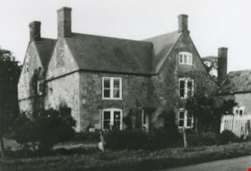
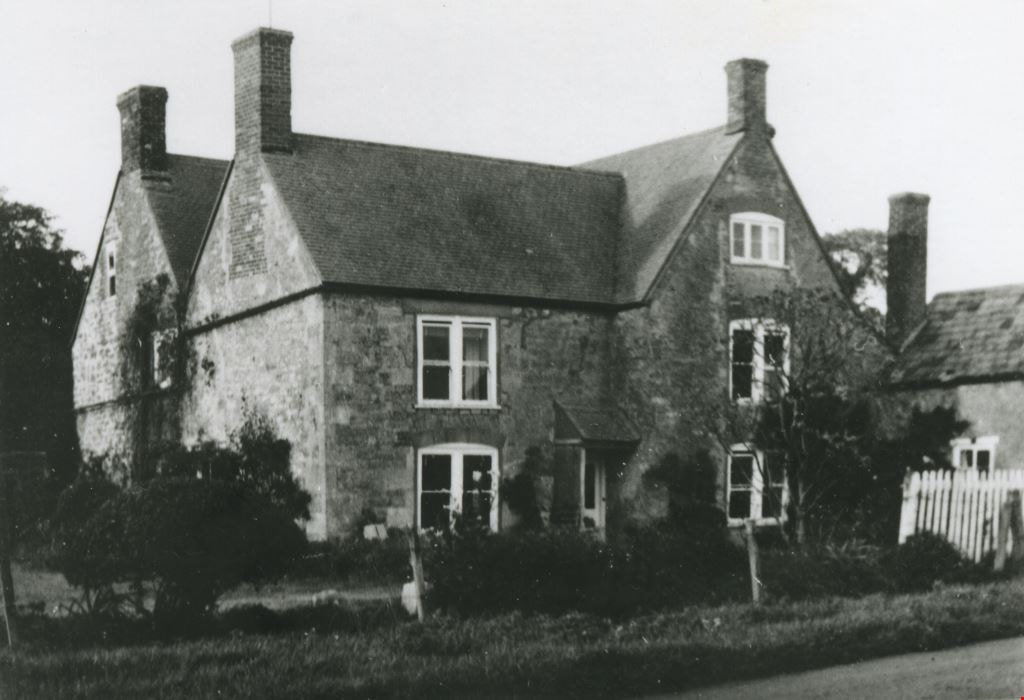
Rowborough Farm
https://search.heritageburnaby.ca/link/archivedescription36206
- Repository
- City of Burnaby Archives
- Date
- 1963
- Collection/Fonds
- Burnaby Historical Society fonds
- Description Level
- Item
- Physical Description
- 1 photograph : b&w ; 7.5 x 11.5 cm print
- Scope and Content
- Photograph of a very large stone building called the Rowborogh Farm, the Love family home in England.
- Repository
- City of Burnaby Archives
- Date
- 1963
- Collection/Fonds
- Burnaby Historical Society fonds
- Subseries
- Love family subseries
- Physical Description
- 1 photograph : b&w ; 7.5 x 11.5 cm print
- Description Level
- Item
- Record No.
- 232-003
- Access Restriction
- No restrictions
- Reproduction Restriction
- Reproduce for fair dealing purposes only
- Accession Number
- BHS1989-24
- Scope and Content
- Photograph of a very large stone building called the Rowborogh Farm, the Love family home in England.
- Media Type
- Photograph
- Notes
- Title based on contents of photograph
- 1 b&w copy negative accompanying
Images
![Thrussell farm and barn, [1914] thumbnail](/media/hpo/_Data/_Archives_Images/_Unrestricted/251/275-009.jpg?width=280)
Thrussell farm and barn
https://search.heritageburnaby.ca/link/archivedescription36477
- Repository
- City of Burnaby Archives
- Date
- [1914]
- Collection/Fonds
- Burnaby Historical Society fonds
- Description Level
- Item
- Physical Description
- 1 photograph : b&w ; 8.5 x 12.5 cm print
- Scope and Content
- Photograph of the Thrussell family farm, including the front gate and barn on Marine Drive, at Nelson Avenue.
- Repository
- City of Burnaby Archives
- Date
- [1914]
- Collection/Fonds
- Burnaby Historical Society fonds
- Subseries
- Thrussell family subseries
- Physical Description
- 1 photograph : b&w ; 8.5 x 12.5 cm print
- Description Level
- Item
- Record No.
- 275-009
- Access Restriction
- No restrictions
- Reproduction Restriction
- No known restrictions
- Accession Number
- BHS1992-05
- Scope and Content
- Photograph of the Thrussell family farm, including the front gate and barn on Marine Drive, at Nelson Avenue.
- Names
- North Arm Dairy
- Media Type
- Photograph
- Notes
- Title based on contents of photograph
- Geographic Access
- Marine Drive
- Nelson Avenue
- Historic Neighbourhood
- Fraser Arm (Historic Neighbourhood)
- Planning Study Area
- Big Bend Area
Images
![Thrussell farm and barn, [1914] thumbnail](/media/hpo/_Data/_Archives_Images/_Unrestricted/251/275-009.jpg)
![Thrussell's farm, [1900] thumbnail](/media/hpo/_Data/_Archives_Images/_Unrestricted/251/275-001.jpg?width=280)
Thrussell's farm
https://search.heritageburnaby.ca/link/archivedescription36470
- Repository
- City of Burnaby Archives
- Date
- [1900]
- Collection/Fonds
- Burnaby Historical Society fonds
- Description Level
- Item
- Physical Description
- 1 photograph : b&w ; 8.5 x 12.5 cm print
- Scope and Content
- Photograph of the North Arm Dairy and the rest of the Thrussell family farm at Marine Drive and Nelson Avenue. Froggers Creek is visible on the left.
- Repository
- City of Burnaby Archives
- Date
- [1900]
- Collection/Fonds
- Burnaby Historical Society fonds
- Subseries
- Thrussell family subseries
- Physical Description
- 1 photograph : b&w ; 8.5 x 12.5 cm print
- Description Level
- Item
- Record No.
- 275-001
- Access Restriction
- No restrictions
- Reproduction Restriction
- No known restrictions
- Accession Number
- BHS1992-05
- Scope and Content
- Photograph of the North Arm Dairy and the rest of the Thrussell family farm at Marine Drive and Nelson Avenue. Froggers Creek is visible on the left.
- Names
- North Arm Dairy
- Media Type
- Photograph
- Notes
- Title based on contents of photograph
- Geographic Access
- Marine Drive
- Nelson Avenue
- Historic Neighbourhood
- Fraser Arm (Historic Neighbourhood)
- Planning Study Area
- Big Bend Area
Images
![Thrussell's farm, [1900] thumbnail](/media/hpo/_Data/_Archives_Images/_Unrestricted/251/275-001.jpg)
![Vegetable building at Oakalla, [195-] (date of original), copied 1991 thumbnail](/media/hpo/_Data/_Archives_Images/_Unrestricted/370/370-714.jpg?width=280)
Vegetable building at Oakalla
https://search.heritageburnaby.ca/link/archivedescription38127
- Repository
- City of Burnaby Archives
- Date
- [195-] (date of original), copied 1991
- Collection/Fonds
- Burnaby Historical Society fonds
- Description Level
- Item
- Physical Description
- 1 photograph : b&w ; 3.1 x 4.6 cm print on contact sheet 20.1 x 26.5 cm
- Scope and Content
- Photograph of the exterior of the vegetable building at Oakalla.
- Repository
- City of Burnaby Archives
- Date
- [195-] (date of original), copied 1991
- Collection/Fonds
- Burnaby Historical Society fonds
- Subseries
- Burnaby Image Bank subseries
- Physical Description
- 1 photograph : b&w ; 3.1 x 4.6 cm print on contact sheet 20.1 x 26.5 cm
- Description Level
- Item
- Record No.
- 370-714
- Access Restriction
- No restrictions
- Reproduction Restriction
- Reproduce for fair dealing purposes only
- Accession Number
- BHS1999-03
- Scope and Content
- Photograph of the exterior of the vegetable building at Oakalla.
- Names
- Oakalla Prison Farm
- Media Type
- Photograph
- Notes
- Title based on contents of photograph
- 1 b&w copy negative accompanying
- Negative has a pink cast
- Geographic Access
- Oakmount Crescent
- Street Address
- 5220 Oakmount Crescent
- Historic Neighbourhood
- Burnaby Lake (Historic Neighbourhood)
- Planning Study Area
- Oakalla Area
Images
![Vegetable building at Oakalla, [195-] (date of original), copied 1991 thumbnail](/media/hpo/_Data/_Archives_Images/_Unrestricted/370/370-714.jpg)
![W.H. Lewis farm, [1900] thumbnail](/media/hpo/_Data/_Archives_Images/_Unrestricted/001/022-002.jpg?width=280)
W.H. Lewis farm
https://search.heritageburnaby.ca/link/archivedescription34499
- Repository
- City of Burnaby Archives
- Date
- [1900]
- Collection/Fonds
- Burnaby Historical Society fonds
- Description Level
- Item
- Physical Description
- 1 photograph : sepia ; 12.6 x 17.7 cm mounted on cardboard 14.2 x 19.3 cm
- Scope and Content
- Photograph of W.H. Lewis' fruit farm with a man, three women and five children kneeling in a strawberry field. "Pioneer Tales" identifies them as William Lewis (foreground), three of his children, and hired help. A house can be seen in the background. The Lewis house was located on 4th Street.
- Repository
- City of Burnaby Archives
- Date
- [1900]
- Collection/Fonds
- Burnaby Historical Society fonds
- Subseries
- Photographs subseries
- Physical Description
- 1 photograph : sepia ; 12.6 x 17.7 cm mounted on cardboard 14.2 x 19.3 cm
- Description Level
- Item
- Record No.
- 022-002
- Access Restriction
- No restrictions
- Reproduction Restriction
- No known restrictions
- Accession Number
- BHS2007-04
- Scope and Content
- Photograph of W.H. Lewis' fruit farm with a man, three women and five children kneeling in a strawberry field. "Pioneer Tales" identifies them as William Lewis (foreground), three of his children, and hired help. A house can be seen in the background. The Lewis house was located on 4th Street.
- Media Type
- Photograph
- Photographer
- Cooksley, William Thomas
- Notes
- Title based on contents of photograph
- Annotation at bottom of photograph reads, "W.H. Lewis' Fruit Farm, Burnaby, B.C."
- Geographic Access
- 4th Street
- 18th Avenue
- Historic Neighbourhood
- East Burnaby (Historic Neighbourhood)
- Planning Study Area
- Second Street Area
Images
![W.H. Lewis farm, [1900] thumbnail](/media/hpo/_Data/_Archives_Images/_Unrestricted/001/022-002.jpg)