More like 'Map of Burnaby'
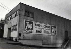
Nordic Centre
https://search.heritageburnaby.ca/link/archivedescription79734
- Repository
- City of Burnaby Archives
- Date
- November 1, 1976
- Collection/Fonds
- Burnaby Public Library Contemporary Visual Archive Project
- Description Level
- Item
- Physical Description
- 1 photograph : b&w ; 11 x 16 cm mounted on cardboard
- Scope and Content
- Photograph shows the Nordic Centre, located on 6th Street on the corner of 12th Avenue. A billboard advertising its services is attached to the side of the building. A few months after this photo was taken, the Nordic Centre was torn down.
- Repository
- City of Burnaby Archives
- Date
- November 1, 1976
- Collection/Fonds
- Burnaby Public Library Contemporary Visual Archive Project
- Physical Description
- 1 photograph : b&w ; 11 x 16 cm mounted on cardboard
- Description Level
- Item
- Record No.
- 556-407
- Access Restriction
- No restrictions
- Reproduction Restriction
- Reproduce for fair dealing purposes only
- Accession Number
- 2013-13
- Scope and Content
- Photograph shows the Nordic Centre, located on 6th Street on the corner of 12th Avenue. A billboard advertising its services is attached to the side of the building. A few months after this photo was taken, the Nordic Centre was torn down.
- Names
- Nordic Centre
- Media Type
- Photograph
- Notes
- Scope note taken directly from BPL photograph description.
- 1 b&w copy negative : 10 x 12.5 cm accompanying
- Photographers identified by surnames only: Carr and Vardeman
- Geographic Access
- 6th Street
- 12th Avenue
- Historic Neighbourhood
- East Burnaby (Historic Neighbourhood)
- Planning Study Area
- Second Street Area
Images
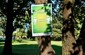
Social distance in Burnaby Parks
https://search.heritageburnaby.ca/link/archivedescription95093
- Repository
- City of Burnaby Archives
- Date
- May 8, 2020
- Collection/Fonds
- Burnaby Photographic Society fonds
- Description Level
- Item
- Physical Description
- 1 photograph (tiff)
- Scope and Content
- Photograph of a City of Burnaby sign encouraging social distancing attached to a tree in Mary Avenue Park.
- Repository
- City of Burnaby Archives
- Date
- May 8, 2020
- Collection/Fonds
- Burnaby Photographic Society fonds
- Physical Description
- 1 photograph (tiff)
- Description Level
- Item
- Record No.
- 623-012
- Access Restriction
- No restrictions
- Reproduction Restriction
- Reproduce for fair dealing purposes only
- Accession Number
- 2020-10
- Scope and Content
- Photograph of a City of Burnaby sign encouraging social distancing attached to a tree in Mary Avenue Park.
- Media Type
- Photograph
- Photographer
- Asbia, Cher
- Notes
- Transcribed title
- Geographic Access
- 12th Avenue
- Historic Neighbourhood
- Edmonds (Historic Neighbourhood)
- Planning Study Area
- Edmonds Area
Images
St. Alban's Anglican Church
https://search.heritageburnaby.ca/link/archivedescription35003
- Repository
- City of Burnaby Archives
- Date
- [1909] (date of original), copied 1986
- Collection/Fonds
- Burnaby Historical Society fonds
- Description Level
- Item
- Physical Description
- 1 photograph : b&w postcard ; 8.5 x 11.8 cm
- Scope and Content
- Photograph on a postcard of the exterior of St. Alban's Anglican Church at 7717 19th Avenue, near Douglas Road (now Canada Way) and Edmonds Street.
- Repository
- City of Burnaby Archives
- Date
- [1909] (date of original), copied 1986
- Collection/Fonds
- Burnaby Historical Society fonds
- Subseries
- Patterson family subseries
- Physical Description
- 1 photograph : b&w postcard ; 8.5 x 11.8 cm
- Description Level
- Item
- Record No.
- 171-024
- Access Restriction
- No restrictions
- Reproduction Restriction
- No known restrictions
- Accession Number
- BHS1986-20
- Scope and Content
- Photograph on a postcard of the exterior of St. Alban's Anglican Church at 7717 19th Avenue, near Douglas Road (now Canada Way) and Edmonds Street.
- Media Type
- Photograph
- Notes
- Title based on contents of photograph
- Geographic Access
- 19th Avenue
- Street Address
- 7717 19th Avenue
- Historic Neighbourhood
- Edmonds (Historic Neighbourhood)
- Planning Study Area
- Edmonds Area
Images
St. Albans the Martyr Church
https://search.heritageburnaby.ca/link/archivedescription38517
- Repository
- City of Burnaby Archives
- Date
- [1912]
- Collection/Fonds
- Burnaby Historical Society fonds
- Description Level
- Item
- Physical Description
- 1 photograph : b&w postcard ; 8.5 x 14 cm
- Scope and Content
- Photographic postcard of the St. Albans the Martyr Church at Canada Way and 19th Avenue.
- Repository
- City of Burnaby Archives
- Date
- [1912]
- Collection/Fonds
- Burnaby Historical Society fonds
- Subseries
- Photographs subseries
- Physical Description
- 1 photograph : b&w postcard ; 8.5 x 14 cm
- Description Level
- Item
- Record No.
- 449-012
- Access Restriction
- No restrictions
- Reproduction Restriction
- No known restrictions
- Accession Number
- BHS2007-04
- Scope and Content
- Photographic postcard of the St. Albans the Martyr Church at Canada Way and 19th Avenue.
- Media Type
- Photograph
- Notes
- Title based on contents of photograph
- Geographic Access
- Canada Way
- 19th Avenue
- Street Address
- 7717 19th Avenue
- Historic Neighbourhood
- Edmonds (Historic Neighbourhood)
- Planning Study Area
- Edmonds Area


![St. Alban's Anglican Church, [1909] (date of original), copied 1986 thumbnail](/media/hpo/_Data/_Archives_Images/_Unrestricted/126/171-024.jpg?width=280)
![St. Albans the Martyr Church, [1912] thumbnail](/media/hpo/_Data/_Archives_Images/_Unrestricted/371/449-012.jpg?width=280)