More like 'Map of Burnaby'
Narrow Results By
Subject
- Adminstrative Groups - Committees 4
- Adornment 11
- Adornment - Jewelry 2
- Adornment - Lapel Pins 12
- Advertising Medium 104
- Advertising Medium - Business Cards 17
- Advertising Medium - Flyer 38
- Advertising Medium - Poster 17
- Advertising Medium - Signs and Signboards 255
- Aerial Photographs 6
- Agriculture - Crops 2
- Agriculture - Fruit and Berries 5

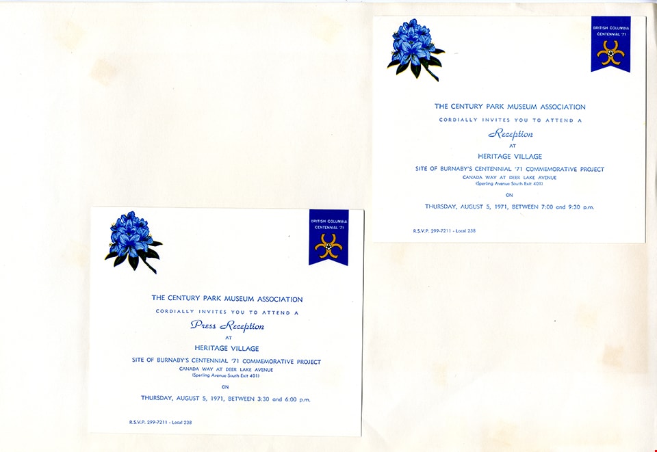
Album page
https://search.heritageburnaby.ca/link/museumartifact90421
- Repository
- Burnaby Village Museum
- Accession Code
- BV005.54.702
- Description
- Album page with two invitations to "Press Reception at Heritage Village" Thursday August 5, 1971 between 3:30 and 6:00pm and "Reception at Heritage Village", Thursday August, 5 1971 between 7:00 and 9:30pm; both invitations are printed with "Burnaby Centennial '71" blue and gold logo (top right corner) and illustration of a blue rhododendrun flower (top left corner).
- Object History
- Album page 174 from Don Copan album/scrapbook for Burnaby Centennial '71 celebrations
- Don Copan was an active member of the Burnaby Centennial ’71 Committee and later became the founding President of the Century Park Museum Association. While a member of the Burnaby Centennial ’71 Committee, Don created a scrapbook album of photographs and ephemera documenting the Burnaby Centennial ’71 Committee’s involvement in celebrating British Columbia’s Centenary of Confederation between January and December 1971 including Burnaby’s Commemorative Project – Heritage Village (Burnaby Village Museum).
- Reference
- Photographs from the Don Copan scrapbook/album are described as part of the Donald Copan collection - Copan Album series
- Category
- 08. Communication Artifacts
- Classification
- Documentary Artifacts - - Other Documents
- Object Term
- Request
Images
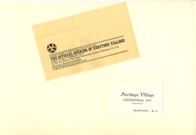
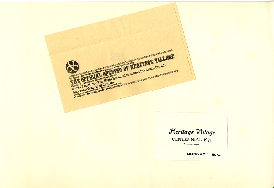
Album page
https://search.heritageburnaby.ca/link/museumartifact90797
- Repository
- Burnaby Village Museum
- Accession Code
- BV005.54.770
- Description
- Album page with invitation and card; Invitation with black text on yellow cartridge paper reads "The Burnaby Centennial '71 Committee Cordially invites you to attend / The Official Opening of Heritage Village / (Burnaby's Centennial '71 Commemorative Project) / by his Excellency The Right Honourable Roland Michener, C.C., C.D. / Governor General of Canada..."; card; black text on glossy cardstock reads "Heritage Village / Centennial 1971 / Burnaby, B.C."
- Object History
- Album page 241 from Don Copan album/scrapbook for Burnaby Centennial '71 celebrations
- Don Copan was an active member of the Burnaby Centennial ’71 Committee and later became the founding President of the Century Park Museum Association. While a member of the Burnaby Centennial ’71 Committee, Don created a scrapbook album of photographs and ephemera documenting the Burnaby Centennial ’71 Committee’s involvement in celebrating British Columbia’s Centenary of Confederation between January and December 1971 including Burnaby’s Commemorative Project – Heritage Village (Burnaby Village Museum).
- Reference
- Photographs from the Don Copan scrapbook/album are described as part of the Donald Copan collection - Copan Album series
- Category
- 08. Communication Artifacts
- Classification
- Documentary Artifacts - - Other Documents
- Object Term
- Card, Advertising
- Request
Images
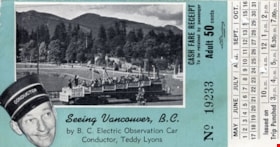
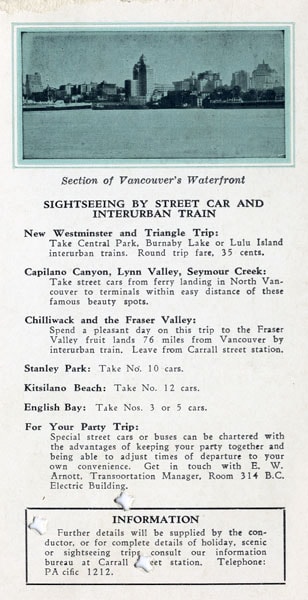
observation car ticket
https://search.heritageburnaby.ca/link/museumartifact7172
- Repository
- Burnaby Village Museum
- Accession Code
- BV985.441.3
- Description
- Seeing Vancouver, B.C. - Ticket Receipt -- 195-?]. Cash Fare Receipt for the B.C. Electric Observation Car. The receipt has a light blue background with a photograph of a Vancouver park and a cut out image of Conductor Teddy Lyons head. The receipt is number 19233. The bottom part of the ticket has been punched on August 14th at 11 a.m. The back side gives suggestions on sightseeing day trips on Street Cars and Interurban Trains within Vancouver and the Lower Mainland.
- Object History
- May have come to BVM via Vancouver Museum [see Accession Register].
- Subjects
- Exchange Medium
- Exchange Medium - Tickets
- Documentary Artifacts
- Documentary Artifacts - Receipts
- Transportation
- Transportation - Electric Railroads
Images

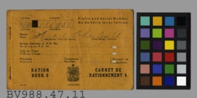
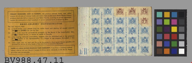
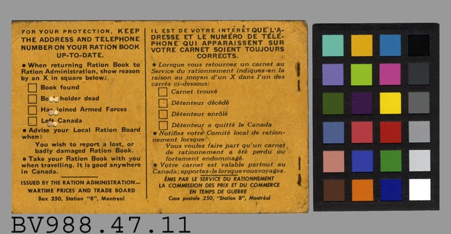
ration book
https://search.heritageburnaby.ca/link/museumartifact4315
- Repository
- Burnaby Village Museum
- Accession Code
- BV988.47.11
- Description
- Ration Book - Booklet -- [194-]. Canadian Ration Book for food during World War II. This ration book was assigned to Charles A. Moore. Inside the booklet are detachable tokens that represent different types of food. The booklet measures 13.5cm x 8.5cm.
- Subjects
- Documentary Artifacts
- Documentary Artifacts - Booklets
- Exchange Medium
- Exchange Medium - Ration Tokens
- Wars
- Wars - World War, 1939-1945
- Emergency Measures - Civil Defence
Images

![Aerial map of Burnaby Mountain, [1995] thumbnail](/media/Hpo/_Data/_Archives_Images/_Unrestricted/629/629-006.jpg?width=280)
Aerial map of Burnaby Mountain
https://search.heritageburnaby.ca/link/archivedescription97805
- Repository
- City of Burnaby Archives
- Date
- [1995]
- Collection/Fonds
- Burnaby Mountain Preservation Society fonds
- Description Level
- Item
- Physical Description
- 1 photograph : col. slide ; 35 mm
- Scope and Content
- Aerial map of Burnaby Mountain.
- Repository
- City of Burnaby Archives
- Date
- [1995]
- Collection/Fonds
- Burnaby Mountain Preservation Society fonds
- Physical Description
- 1 photograph : col. slide ; 35 mm
- Description Level
- Item
- Record No.
- 629-006
- Access Restriction
- No restrictions
- Reproduction Restriction
- Reproduce for fair dealing purposes only
- Accession Number
- 2006-13
- Scope and Content
- Aerial map of Burnaby Mountain.
- Subjects
- Documentary Artifacts - Maps
- Media Type
- Photograph
- Geographic Access
- Burnaby Mountain Conservation Area
- Planning Study Area
- Burnaby Mountain Area
Images
![Aerial map of Burnaby Mountain, [1995] thumbnail](/media/Hpo/_Data/_Archives_Images/_Unrestricted/629/629-006.jpg)
![City of Burnaby digital mapping system, [2002] thumbnail](/media/hpo/_Data/_Archives_Images/_Unrestricted/535/535-2325.jpg?width=280)
City of Burnaby digital mapping system
https://search.heritageburnaby.ca/link/archivedescription96720
- Repository
- City of Burnaby Archives
- Date
- [2002]
- Collection/Fonds
- Burnaby NewsLeader photograph collection
- Description Level
- Item
- Physical Description
- 1 photograph (tiff) : col.
- Scope and Content
- Photograph of Terry Richard, from the City of Burnaby Engineering Department, posing with a map of Burnaby and a desktop computer displaying the City's new digital mapping system.
- Repository
- City of Burnaby Archives
- Date
- [2002]
- Collection/Fonds
- Burnaby NewsLeader photograph collection
- Physical Description
- 1 photograph (tiff) : col.
- Description Level
- Item
- Record No.
- 535-2325
- Access Restriction
- No restrictions
- Reproduction Restriction
- No restrictions
- Accession Number
- 2018-12
- Scope and Content
- Photograph of Terry Richard, from the City of Burnaby Engineering Department, posing with a map of Burnaby and a desktop computer displaying the City's new digital mapping system.
- Media Type
- Photograph
- Photographer
- Bartel, Mario
- Notes
- Title based on caption
- Collected by editorial for use in an April 2002 issue of the Burnaby NewsLeader
- Caption from metadata: "Terry Richard, of Burnaby's Engineering Department, is overseeing the transfer of its mapping system to the internet."
Images
![City of Burnaby digital mapping system, [2002] thumbnail](/media/hpo/_Data/_Archives_Images/_Unrestricted/535/535-2325.jpg)
![Copy of Official British Columbia Road Maps, [193-] thumbnail](/media/hpo/_Data/_BVM_Cartographic_Material/1972/1972_0179_0001_001.jpg?width=280)
Copy of Official British Columbia Road Maps
https://search.heritageburnaby.ca/link/museumdescription18945
- Repository
- Burnaby Village Museum
- Date
- [193-]
- Collection/Fonds
- Burnaby Village Museum Map collection
- Physical Description
- 1 map : lithographic print on sheet ; 43 x 56 cm folded to 22 x 11 cm
- Scope and Content
- Item consists of Road maps of British Columbia presented by Union Oil Company of Canada Limited. Includes seventeen maps printed on both sides of sheet. One side of sheet includes ten separate road maps titled "Cariboo"; "Chilcotin Plateau"; "150 Mile House to Prince George"; "Prince George - Burns…
- Repository
- Burnaby Village Museum
- Collection/Fonds
- Burnaby Village Museum Map collection
- Physical Description
- 1 map : lithographic print on sheet ; 43 x 56 cm folded to 22 x 11 cm
- Material Details
- Scale not defined
- Scope and Content
- Item consists of Road maps of British Columbia presented by Union Oil Company of Canada Limited. Includes seventeen maps printed on both sides of sheet. One side of sheet includes ten separate road maps titled "Cariboo"; "Chilcotin Plateau"; "150 Mile House to Prince George"; "Prince George - Burns Lake"; "Burns Lake - Hazelton"; "Similkameen - Nicola"; "Salmon Arm to Revelstoke"; "Ashcroft to Salmon Arm / Kamloops to Vernon"; "Okanagan Valley"; "Boundary District". Other side of sheet includes seven road maps titled "Vancouver Island"; "Vancouver to Yale"' "Fraser Canyon Section Cariboo Road"; "Lytton to 150 Mile House"; "Arrow and Kootenay Lakes"; "The Kootenays"; "Columbia Valley". When folded, cover of maps reads "COPY OF / OFFICIAL / BRITISH COLUMBIA / ROAD-MAPS" / Presented by / UNION OIL / COMPANY / of Canada Ltd."; verso of cover includes advertisement for Union Motor oil "MOTORITE"; inside cover includes advertisement for Union Gasoline with title reading "See Canada's Evergreen Playground".
- Responsibility
- Union Oil Company of Canada Limited
- Accession Code
- HV972.179.1
- Access Restriction
- No restrictions
- Reproduction Restriction
- No known restrictions
- Date
- [193-]
- Media Type
- Cartographic Material
- Scan Resolution
- 600
- Scan Date
- 2023-08-17
- Notes
- Title based on contents of map
Images
![Copy of Official British Columbia Road Maps, [193-] thumbnail](/media/hpo/_Data/_BVM_Cartographic_Material/1972/1972_0179_0001_001.jpg)


Early maps of Burnaby
https://search.heritageburnaby.ca/link/archivedescription36450
- Repository
- City of Burnaby Archives
- Date
- 1990
- Collection/Fonds
- Burnaby Historical Society fonds
- Description Level
- Item
- Physical Description
- 1 photograph : col. ; 15 x 10 cm
- Scope and Content
- Photograph of a display that included early maps of the Burnaby area as part of the opening of the Burnaby Community Archives at the Burnaby Village Museum.
- Repository
- City of Burnaby Archives
- Date
- 1990
- Collection/Fonds
- Burnaby Historical Society fonds
- Subseries
- Donald N. Brown subseries
- Physical Description
- 1 photograph : col. ; 15 x 10 cm
- Description Level
- Item
- Record No.
- 271-018
- Access Restriction
- No restrictions
- Reproduction Restriction
- Reproduce for fair dealing purposes only
- Accession Number
- BHS1991-41
- Scope and Content
- Photograph of a display that included early maps of the Burnaby area as part of the opening of the Burnaby Community Archives at the Burnaby Village Museum.
- Subjects
- Documentary Artifacts - Maps
- Media Type
- Photograph
- Notes
- Title based on contents of photograph
- 1 photograph : col. negative ; 35 mm accompanying
- Geographic Access
- Deer Lake Avenue
- Street Address
- 6501 Deer Lake Avenue
- Historic Neighbourhood
- Burnaby Lake (Historic Neighbourhood)
- Planning Study Area
- Morley-Buckingham Area
Images

map
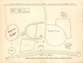
https://search.heritageburnaby.ca/link/museumartifact87474
- Repository
- Burnaby Village Museum
- Accession Code
- BV015.35.83
- Description
- map; "SKETCH MAP OF CANADIAN GIRL GUIDE CAMP, WILSON CREEK"; hand-drawn map shows locations of campsites, trails, roads, bathing beach, chapel, playing field, etc.; back of map has text in brown ink reading: "Over the hill and / down the valley" and Over the ill & do"
- Object History
- Map belonged to Dorothy Pitman who was a Girl Guide in the 1st Burnaby Company. She was known to be involved with guiding from 1919 to 1931. Textual records and photographs of the Pitman family, including one of Dorothy and her sister Gwen, are held by the City of Burnaby Archives. Dorothy and Gwen's parents, Ernest and Jean Pitman, owned McKay Dry Goods and Jubilee Dry Goods.
- Category
- 08. Communication Artifacts
- Classification
- Documentary Artifacts - - Graphic Documents
- Object Term
- Cartograph, Map
Images

Maps and charts on display
https://search.heritageburnaby.ca/link/archivedescription36451
- Repository
- City of Burnaby Archives
- Date
- 1990
- Collection/Fonds
- Burnaby Historical Society fonds
- Description Level
- Item
- Physical Description
- 1 photograph : col. ; 15 x 10 cm
- Scope and Content
- Photograph of maps and charts on display at the opening of the Burnaby Community Archives at the Burnaby Village Museum.
- Repository
- City of Burnaby Archives
- Date
- 1990
- Collection/Fonds
- Burnaby Historical Society fonds
- Subseries
- Donald N. Brown subseries
- Physical Description
- 1 photograph : col. ; 15 x 10 cm
- Description Level
- Item
- Record No.
- 271-019
- Access Restriction
- No restrictions
- Reproduction Restriction
- Reproduce for fair dealing purposes only
- Accession Number
- BHS1991-41
- Scope and Content
- Photograph of maps and charts on display at the opening of the Burnaby Community Archives at the Burnaby Village Museum.
- Subjects
- Documentary Artifacts - Maps
- Media Type
- Photograph
- Notes
- Title based on contents of photograph
- 1 photograph : col. negative ; 35 mm accompanying
- Geographic Access
- Deer Lake Avenue
- Street Address
- 6501 Deer Lake Avenue
- Historic Neighbourhood
- Burnaby Lake (Historic Neighbourhood)
- Planning Study Area
- Morley-Buckingham Area
Images

![Margaret Manifold and the Community Asset Mapping System, [2005] thumbnail](/media/hpo/_Data/_Archives_Images/_Unrestricted/535/535-1927-1.jpg?width=280)
Margaret Manifold and the Community Asset Mapping System
https://search.heritageburnaby.ca/link/archivedescription96243
- Repository
- City of Burnaby Archives
- Date
- [2005]
- Collection/Fonds
- Burnaby NewsLeader photograph collection
- Description Level
- File
- Physical Description
- 2 photographs (tiff) : col.
- Scope and Content
- File contains photographs of Margaret Manifold, of the City of Burnaby Planning Department, posing with print-outs of maps that will form the online Community Asset Mapping System. A large aerial photograph of Burnaby and the Lower Mainland is on the wall behind Manifold.
- Repository
- City of Burnaby Archives
- Date
- [2005]
- Collection/Fonds
- Burnaby NewsLeader photograph collection
- Physical Description
- 2 photographs (tiff) : col.
- Description Level
- File
- Record No.
- 535-1927
- Access Restriction
- No restrictions
- Reproduction Restriction
- No restrictions
- Accession Number
- 2018-12
- Scope and Content
- File contains photographs of Margaret Manifold, of the City of Burnaby Planning Department, posing with print-outs of maps that will form the online Community Asset Mapping System. A large aerial photograph of Burnaby and the Lower Mainland is on the wall behind Manifold.
- Media Type
- Photograph
- Photographer
- Medig, Kari
- Notes
- Title based on caption
- Collected by editorial for use in a February 2005 issue of the Burnaby NewsLeader
- Caption from metadata: "Margaret Manifold of the City of Burnaby's planning department poses with some hard copies of the online Community Assett Mapping System, which will soon be on the city's website."
Images
![Margaret Manifold and the Community Asset Mapping System, [2005] thumbnail](/media/hpo/_Data/_Archives_Images/_Unrestricted/535/535-1927-1.jpg)
![School room at Oakalla, [195-] (date of original), copied 1991 thumbnail](/media/hpo/_Data/_Archives_Images/_Unrestricted/370/370-733.jpg?width=280)
School room at Oakalla
https://search.heritageburnaby.ca/link/archivedescription38146
- Repository
- City of Burnaby Archives
- Date
- [195-] (date of original), copied 1991
- Collection/Fonds
- Burnaby Historical Society fonds
- Description Level
- Item
- Physical Description
- 1 photograph : b&w ; 3.6 x 4.4 cm print on contact sheet 20.6 x 26.8 cm
- Scope and Content
- Photograph of the interior of a school room at Oakalla Prison Farm. Men are seated at desks, and a student and teacher are at the blackboard standing beside a map. A list of words is on the blackboard.
- Repository
- City of Burnaby Archives
- Date
- [195-] (date of original), copied 1991
- Collection/Fonds
- Burnaby Historical Society fonds
- Subseries
- Burnaby Image Bank subseries
- Physical Description
- 1 photograph : b&w ; 3.6 x 4.4 cm print on contact sheet 20.6 x 26.8 cm
- Description Level
- Item
- Record No.
- 370-733
- Access Restriction
- No restrictions
- Reproduction Restriction
- Reproduce for fair dealing purposes only
- Accession Number
- BHS1999-03
- Scope and Content
- Photograph of the interior of a school room at Oakalla Prison Farm. Men are seated at desks, and a student and teacher are at the blackboard standing beside a map. A list of words is on the blackboard.
- Subjects
- Documentary Artifacts - Maps
- Buildings - Public - Detention Facilities
- Buildings - Schools
- Occupations - Teachers
- Names
- Oakalla Prison Farm
- Media Type
- Photograph
- Notes
- Title based on contents of photograph
- 1 b&w copy negative accompanying
- Negative has a pink cast
- Geographic Access
- Oakmount Crescent
- Street Address
- 5220 Oakmount Crescent
- Historic Neighbourhood
- Burnaby Lake (Historic Neighbourhood)
- Planning Study Area
- Oakalla Area
Images
![School room at Oakalla, [195-] (date of original), copied 1991 thumbnail](/media/hpo/_Data/_Archives_Images/_Unrestricted/370/370-733.jpg)
![SFU Geography class with maps, [2000] thumbnail](/media/hpo/_Data/_Archives_Images/_Unrestricted/535/535-2626.jpg?width=280)
SFU Geography class with maps
https://search.heritageburnaby.ca/link/archivedescription97099
- Repository
- City of Burnaby Archives
- Date
- [2000]
- Collection/Fonds
- Burnaby NewsLeader photograph collection
- Description Level
- Item
- Physical Description
- 1 photograph (tiff) : col.
- Scope and Content
- Photograph of Mike Carr and Simon Fraser University Geography students Dallas Arcangel, Dave Crossley, Caoimhe Kehler and Peter Schaub with maps of "Salmonopolis." They are standing on the roof of an SFU building with forest and mountains visible in the background.
- Repository
- City of Burnaby Archives
- Date
- [2000]
- Collection/Fonds
- Burnaby NewsLeader photograph collection
- Physical Description
- 1 photograph (tiff) : col.
- Description Level
- Item
- Record No.
- 535-2626
- Access Restriction
- No restrictions
- Reproduction Restriction
- No restrictions
- Accession Number
- 2018-12
- Scope and Content
- Photograph of Mike Carr and Simon Fraser University Geography students Dallas Arcangel, Dave Crossley, Caoimhe Kehler and Peter Schaub with maps of "Salmonopolis." They are standing on the roof of an SFU building with forest and mountains visible in the background.
- Names
- Simon Fraser University
- Media Type
- Photograph
- Photographer
- Bartel, Mario
- Notes
- Title based on caption
- Collected by editorial for use in a July 2000 issue of the Burnaby NewsLeader
- Caption from metadata: "SFU geography instructor Mike Carr, and his team of students (front to back), Dallas Arcangel, Dave Crossley, Caoimhe Kehler and Peter Schaub, examine the maps of "Salmonopolis" they've created as part of a plan to create a sustainable region."
- Geographic Access
- Burnaby Mountain Conservation Area
- University Drive
- Street Address
- 8888 University Drive
- Planning Study Area
- Burnaby Mountain Area
Images
![SFU Geography class with maps, [2000] thumbnail](/media/hpo/_Data/_Archives_Images/_Unrestricted/535/535-2626.jpg)
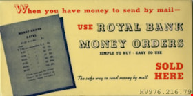
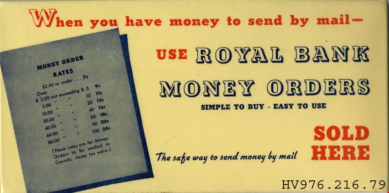
sign
https://search.heritageburnaby.ca/link/museumartifact23322
- Repository
- Burnaby Village Museum
- Accession Code
- HV976.216.79
- Description
- Money Orders - Sign. Advertising sign for a safe way to send money by mail through Royal Bank of Canada Money Orders. Rectangular sign that has yellowed, with red and blue text. The sign shows the rates for purchasing a money order. The back side is black with a string for hanging.
Images
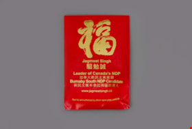
Chinese New Year envelope
https://search.heritageburnaby.ca/link/museumartifact89950
- Repository
- Burnaby Village Museum
- Accession Code
- BV019.16.3
- Description
- Chinese New Year envelope; red paper with gummed, fold closure at top; text in Chinese and English in gold reading: "Jagmeet Singh / Leader of Canada's NDP / Burnaby South NDP Candidate / www.jagmeetsingh.ca / Paid for and authorized by official agent of the candidate."; contains a small, square orange-flavoured candy and a thin card; card has the candidate's name and photograph on one side, and the Chinese zodiac on the other.
- Object History
- Jagmeet Singh is a Canadian lawyer and politician serving as leader of the New Democratic Party since 2017. He was elected as the Member of Parliament (MP) for the riding of Burnaby South in a February 25, 2019 by-election.
- Classification
- Merchandising T&E
- Object Term
- Envelope, Money
- Subjects
- Advertising Medium
- Holidays - Chinese New Year
- Persons - South Asian Canadians
- Officials - Elected Officials
- Celebrations
- Names
- Singh, Jagmeet
Images
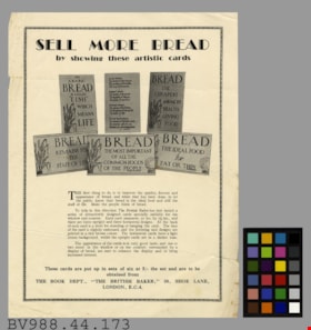
advertisement
https://search.heritageburnaby.ca/link/museumartifact4279
- Repository
- Burnaby Village Museum
- Accession Code
- BV988.44.173
- Description
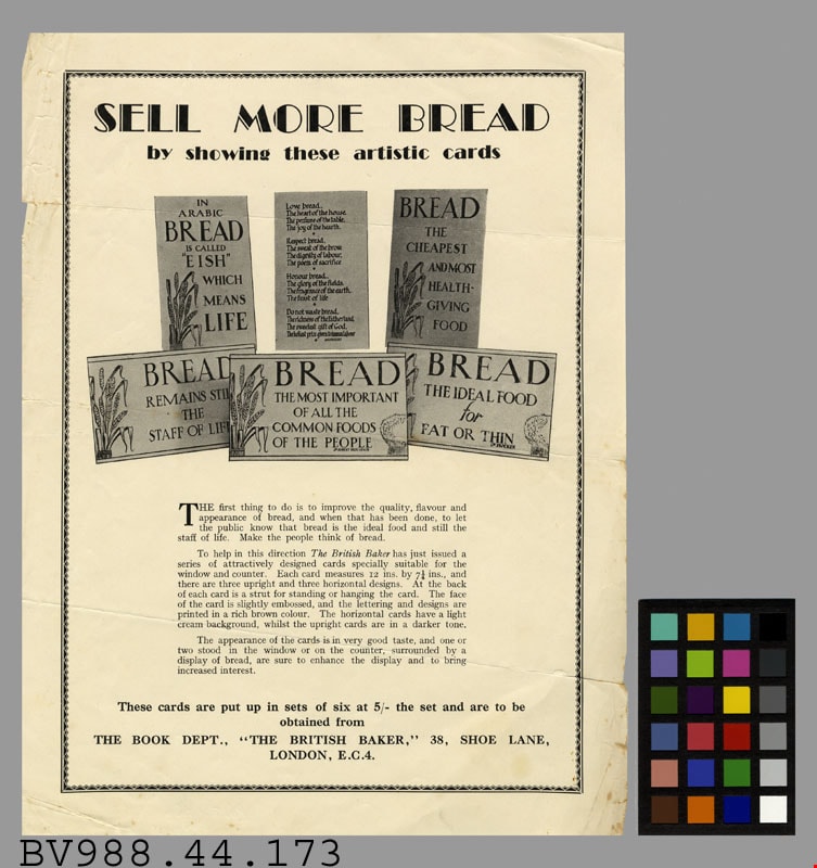
- Sell More Bread - Advertisement Flyer -- [192-?]. Advertising flyer for artistic cards promoting bread. The cards are supposed to inform the public that bread is the ideal food. The cards are produced by "The British Baker" at 38 Shoe Lane, London England. The flyer states that six of the cards can be purchased at 5/-. The flyer measures 21.5cm x 28.5cm.
- Colour
- Beige
- Title
- Sell More Bread
Images
advertisement
https://search.heritageburnaby.ca/link/museumartifact36702
- Repository
- Burnaby Village Museum
- Accession Code
- BV995.9.21
- Description
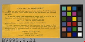
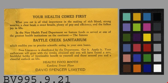
- Your Health Comes First - Advertisement -- [192-?]. Advertisement from David Spencer Limited regarding their Health Food Booth and New Health Food Department. The Health Food Department featured food served at Battle Creek Sanitarium, enabling the customer to practice scientific eating in their own home. The advertisement measures 14.5cm x 8cm.
- Object History
- Donor inherited object from the estate of his father, Dr. Stanley H. Sievenpiper.
- Colour
- Yellow
- Maker
- David Spencer Limited
- Country Made
- Canada
- Province Made
- British Columbia
- Site/City Made
- Vancouver
- Names
- David Spencer Limited
Images
advertisement
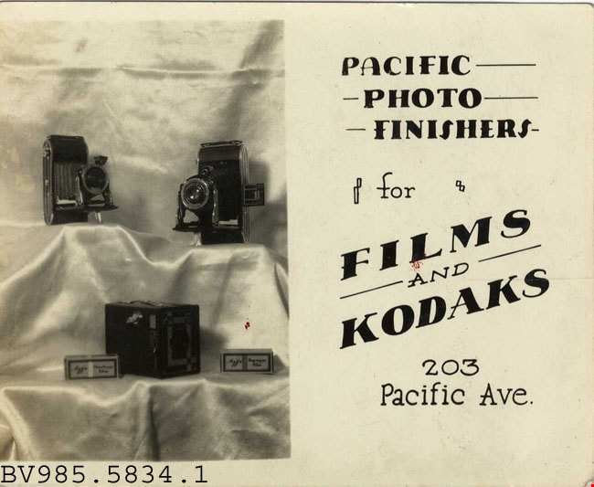
https://search.heritageburnaby.ca/link/museumartifact40335
- Repository
- Burnaby Village Museum
- Accession Code
- BV985.5834.1
- Description
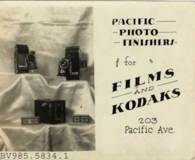
- Pacific Photo Finishers - Advertisement card. Small card advertising for the Pacific Photo Finishers on 203 Pacific Ave. The card advertises that they sell films and Kodaks. There is a small photograph of cameras and accessories on the left side of the card.
Images
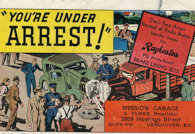
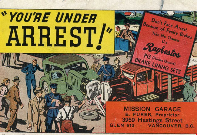
advertisement; blotter
https://search.heritageburnaby.ca/link/museumartifact40410
- Repository
- Burnaby Village Museum
- Accession Code
- BV985.5851.1
- Description
- Mission Garage - Advertisement Blotter. Advertisment card for the Mission Garage at 3959 Hastings Street Vancouver, run by E. Furer. (Although the address on the card says Vancouver, it is actually in Burnaby, part of the Vancouver Heights community.) The front of the card has an illustration of an automobile accident. There is a caption at the top of the card "You're Under Arrest!" and another caption on the side of the card "Don't Face Arrest Because of Faulty Brakes...". The reverse side of the card has pink construction paper which has been used as an ink blotter.
- Subjects
- Written Communication Tools and Equipment
- Written Communication Tools and Equipment - Blotter
- Advertising Medium
- Advertising Medium - Business Cards
- Historic Neighbourhood
- Vancouver Heights (Historic Neighbourhood)
Images
advertisement; blotter
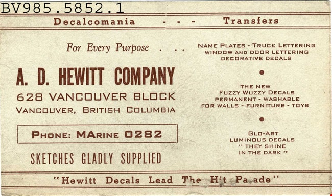
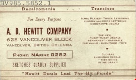
https://search.heritageburnaby.ca/link/museumartifact40411
- Repository
- Burnaby Village Museum
- Accession Code
- BV985.5852.1
- Description
- A.D. Hewitt Company - Advertisment Blotter. Advertisement card for A.D.Hewitt Company, a decal company in Vancouver BC. The card promotes Name Plates, Truck Lettering, Window and Door Lettering among other serives. The back of the card has been used as an ink blotter.
- Subjects
- Written Communication Tools and Equipment
- Written Communication Tools and Equipment - Blotter
- Advertising Medium
- Advertising Medium - Business Cards
- Historic Neighbourhood
- Vancouver Heights (Historic Neighbourhood)
Images