More like 'Interview with Mary Lumby by Kathy Bossort January 8, 2016 - Track 3'
Burnaby's COVID-19 drive thru testing site
https://search.heritageburnaby.ca/link/museumdescription15374
- Repository
- Burnaby Village Museum
- Date
- 5 Apr. 2020
- Collection/Fonds
- Burnaby Village Museum COVID-19 collection
- Description Level
- Item
- Physical Description
- 1 photograph (jpg)
- Scope and Content
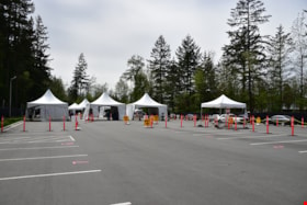
- Photograph of the COVID-19 drive thru testing site in Central Park parking lot in Burnaby. Orange traffic posts and wayfinding signs are set up in the parking lot.
- Repository
- Burnaby Village Museum
- Collection/Fonds
- Burnaby Village Museum COVID-19 collection
- Description Level
- Item
- Physical Description
- 1 photograph (jpg)
- Scope and Content
- Photograph of the COVID-19 drive thru testing site in Central Park parking lot in Burnaby. Orange traffic posts and wayfinding signs are set up in the parking lot.
- Subjects
- Advertising Medium - Signs and Signboards
- Geographic Features - Parks
- Public Services - Health Services
- Pandemics - COVID-19
- Geographic Access
- Central Park
- Imperial Street
- Accession Code
- BV021.2.39
- Access Restriction
- No restrictions
- Reproduction Restriction
- May be restricted by third party rights
- Date
- 5 Apr. 2020
- Media Type
- Photograph
- Historic Neighbourhood
- Central Park (Historic Neighbourhood)
- Planning Study Area
- Maywood Area
- Notes
- Title based on contents of photograph
Images
Burnaby's COVID-19 drive thru testing site
https://search.heritageburnaby.ca/link/museumdescription15375
- Repository
- Burnaby Village Museum
- Date
- 5 Apr. 2020
- Collection/Fonds
- Burnaby Village Museum COVID-19 collection
- Description Level
- Item
- Physical Description
- 1 photograph (jpg)
- Scope and Content
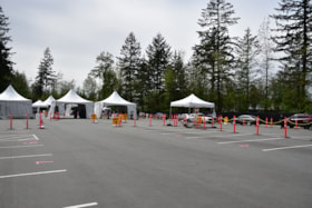
- Photograph of the COVID-19 drive thru testing site in Central Park parking lot in Burnaby. Orange traffic posts, wayfinding signs and white tents are set up in the parking lot.
- Repository
- Burnaby Village Museum
- Collection/Fonds
- Burnaby Village Museum COVID-19 collection
- Description Level
- Item
- Physical Description
- 1 photograph (jpg)
- Scope and Content
- Photograph of the COVID-19 drive thru testing site in Central Park parking lot in Burnaby. Orange traffic posts, wayfinding signs and white tents are set up in the parking lot.
- Subjects
- Advertising Medium - Signs and Signboards
- Geographic Features - Parks
- Public Services - Health Services
- Pandemics - COVID-19
- Geographic Access
- Central Park
- Imperial Street
- Accession Code
- BV021.2.40
- Access Restriction
- No restrictions
- Reproduction Restriction
- May be restricted by third party rights
- Date
- 5 Apr. 2020
- Media Type
- Photograph
- Historic Neighbourhood
- Central Park (Historic Neighbourhood)
- Planning Study Area
- Maywood Area
- Notes
- Title based on contents of photograph
Images
Burnaby's COVID-19 drive thru testing site
https://search.heritageburnaby.ca/link/museumdescription15376
- Repository
- Burnaby Village Museum
- Date
- 5 Apr. 2020
- Collection/Fonds
- Burnaby Village Museum COVID-19 collection
- Description Level
- Item
- Physical Description
- 1 photograph (jpg)
- Scope and Content
- Photograph of the COVID-19 drive thru testing site in Central Park parking lot in Burnaby. Orange traffic posts, wayfinding signs and white tents are set up in the parking lot.
- Repository
- Burnaby Village Museum
- Collection/Fonds
- Burnaby Village Museum COVID-19 collection
- Description Level
- Item
- Physical Description
- 1 photograph (jpg)
- Scope and Content
- Photograph of the COVID-19 drive thru testing site in Central Park parking lot in Burnaby. Orange traffic posts, wayfinding signs and white tents are set up in the parking lot.
- Subjects
- Advertising Medium - Signs and Signboards
- Geographic Features - Parks
- Public Services - Health Services
- Pandemics - COVID-19
- Geographic Access
- Central Park
- Imperial Street
- Accession Code
- BV021.2.41
- Access Restriction
- No restrictions
- Reproduction Restriction
- May be restricted by third party rights
- Date
- 5 Apr. 2020
- Media Type
- Photograph
- Historic Neighbourhood
- Central Park (Historic Neighbourhood)
- Planning Study Area
- Maywood Area
- Notes
- Title based on contents of photograph
Images
Burnaby's COVID-19 drive thru testing site
https://search.heritageburnaby.ca/link/museumdescription15377
- Repository
- Burnaby Village Museum
- Date
- 5 Apr. 2020
- Collection/Fonds
- Burnaby Village Museum COVID-19 collection
- Description Level
- Item
- Physical Description
- 1 photograph (jpg)
- Scope and Content
- Photograph of the COVID-19 drive thru testing site in Central Park parking lot in Burnaby. Orange traffic posts, wayfinding signs and white tents are set up in the parking lot.
- Repository
- Burnaby Village Museum
- Collection/Fonds
- Burnaby Village Museum COVID-19 collection
- Description Level
- Item
- Physical Description
- 1 photograph (jpg)
- Scope and Content
- Photograph of the COVID-19 drive thru testing site in Central Park parking lot in Burnaby. Orange traffic posts, wayfinding signs and white tents are set up in the parking lot.
- Subjects
- Advertising Medium - Signs and Signboards
- Geographic Features - Parks
- Public Services - Health Services
- Pandemics - COVID-19
- Geographic Access
- Central Park
- Imperial Street
- Accession Code
- BV021.2.42
- Access Restriction
- No restrictions
- Reproduction Restriction
- May be restricted by third party rights
- Date
- 5 Apr. 2020
- Media Type
- Photograph
- Historic Neighbourhood
- Central Park (Historic Neighbourhood)
- Planning Study Area
- Maywood Area
- Notes
- Title based on contents of photograph
Images
Burnaby's COVID-19 drive thru testing site
https://search.heritageburnaby.ca/link/museumdescription15378
- Repository
- Burnaby Village Museum
- Date
- 5 Apr. 2020
- Collection/Fonds
- Burnaby Village Museum COVID-19 collection
- Description Level
- Item
- Physical Description
- 1 photograph (jpg)
- Scope and Content
- Photograph of the COVID-19 drive thru testing site in Central Park parking lot in Burnaby. Orange traffic posts, wayfinding signs and white tents are set up in the parking lot.
- Repository
- Burnaby Village Museum
- Collection/Fonds
- Burnaby Village Museum COVID-19 collection
- Description Level
- Item
- Physical Description
- 1 photograph (jpg)
- Scope and Content
- Photograph of the COVID-19 drive thru testing site in Central Park parking lot in Burnaby. Orange traffic posts, wayfinding signs and white tents are set up in the parking lot.
- Subjects
- Advertising Medium - Signs and Signboards
- Geographic Features - Parks
- Public Services - Health Services
- Pandemics - COVID-19
- Geographic Access
- Central Park
- Imperial Street
- Accession Code
- BV021.2.43
- Access Restriction
- No restrictions
- Reproduction Restriction
- May be restricted by third party rights
- Date
- 5 Apr. 2020
- Media Type
- Photograph
- Historic Neighbourhood
- Central Park (Historic Neighbourhood)
- Planning Study Area
- Maywood Area
- Notes
- Title based on contents of photograph
Images
Burnaby's COVID-19 drive thru testing site
https://search.heritageburnaby.ca/link/museumdescription15379
- Repository
- Burnaby Village Museum
- Date
- 5 Apr. 2020
- Collection/Fonds
- Burnaby Village Museum COVID-19 collection
- Description Level
- Item
- Physical Description
- 1 photograph (jpg)
- Scope and Content
- Photograph of the COVID-19 drive thru testing site in Central Park parking lot in Burnaby. Orange traffic posts, wayfinding signs, white tents and white buildings converted from shipping containers are set up in the parking lot.
- Repository
- Burnaby Village Museum
- Collection/Fonds
- Burnaby Village Museum COVID-19 collection
- Description Level
- Item
- Physical Description
- 1 photograph (jpg)
- Scope and Content
- Photograph of the COVID-19 drive thru testing site in Central Park parking lot in Burnaby. Orange traffic posts, wayfinding signs, white tents and white buildings converted from shipping containers are set up in the parking lot.
- Subjects
- Advertising Medium - Signs and Signboards
- Geographic Features - Parks
- Public Services - Health Services
- Pandemics - COVID-19
- Geographic Access
- Central Park
- Imperial Street
- Accession Code
- BV021.2.44
- Access Restriction
- No restrictions
- Reproduction Restriction
- May be restricted by third party rights
- Date
- 5 Apr. 2020
- Media Type
- Photograph
- Historic Neighbourhood
- Central Park (Historic Neighbourhood)
- Planning Study Area
- Maywood Area
- Notes
- Title based on contents of photograph
Images
Burnaby's COVID-19 drive thru testing site
https://search.heritageburnaby.ca/link/museumdescription15380
- Repository
- Burnaby Village Museum
- Date
- 5 Apr. 2020
- Collection/Fonds
- Burnaby Village Museum COVID-19 collection
- Description Level
- Item
- Physical Description
- 1 photograph (jpg)
- Scope and Content
- Photograph of the COVID-19 drive thru testing site in Central Park parking lot in Burnaby. Orange traffic posts, wayfinding signs and white tents are set up in the parking lot.
- Repository
- Burnaby Village Museum
- Collection/Fonds
- Burnaby Village Museum COVID-19 collection
- Description Level
- Item
- Physical Description
- 1 photograph (jpg)
- Scope and Content
- Photograph of the COVID-19 drive thru testing site in Central Park parking lot in Burnaby. Orange traffic posts, wayfinding signs and white tents are set up in the parking lot.
- Subjects
- Advertising Medium - Signs and Signboards
- Geographic Features - Parks
- Public Services - Health Services
- Pandemics - COVID-19
- Geographic Access
- Central Park
- Imperial Street
- Accession Code
- BV021.2.45
- Access Restriction
- No restrictions
- Reproduction Restriction
- May be restricted by third party rights
- Date
- 5 Apr. 2020
- Media Type
- Photograph
- Historic Neighbourhood
- Central Park (Historic Neighbourhood)
- Planning Study Area
- Maywood Area
- Notes
- Title based on contents of photograph
Images
Burnaby's COVID-19 drive thru testing site
https://search.heritageburnaby.ca/link/museumdescription15381
- Repository
- Burnaby Village Museum
- Date
- 5 Apr. 2020
- Collection/Fonds
- Burnaby Village Museum COVID-19 collection
- Description Level
- Item
- Physical Description
- 1 photograph (jpg)
- Scope and Content
- Photograph of the COVID-19 drive thru testing site in Central Park parking lot in Burnaby. Orange traffic posts, wayfinding signs and white tents are set up in the parking lot.
- Repository
- Burnaby Village Museum
- Collection/Fonds
- Burnaby Village Museum COVID-19 collection
- Description Level
- Item
- Physical Description
- 1 photograph (jpg)
- Scope and Content
- Photograph of the COVID-19 drive thru testing site in Central Park parking lot in Burnaby. Orange traffic posts, wayfinding signs and white tents are set up in the parking lot.
- Subjects
- Advertising Medium - Signs and Signboards
- Geographic Features - Parks
- Public Services - Health Services
- Pandemics - COVID-19
- Geographic Access
- Central Park
- Imperial Street
- Accession Code
- BV021.2.46
- Access Restriction
- No restrictions
- Reproduction Restriction
- May be restricted by third party rights
- Date
- 5 Apr. 2020
- Media Type
- Photograph
- Historic Neighbourhood
- Central Park (Historic Neighbourhood)
- Planning Study Area
- Maywood Area
- Notes
- Title based on contents of photograph
Images
Burnaby's COVID-19 drive thru testing site
https://search.heritageburnaby.ca/link/museumdescription15382
- Repository
- Burnaby Village Museum
- Date
- 5 Apr. 2020
- Collection/Fonds
- Burnaby Village Museum COVID-19 collection
- Description Level
- Item
- Physical Description
- 1 photograph (jpg)
- Scope and Content
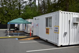
- Photograph of the COVID-19 drive thru testing site in Central Park parking lot in Burnaby. White shipping container buildings have been set up in the parking lot.
- Repository
- Burnaby Village Museum
- Collection/Fonds
- Burnaby Village Museum COVID-19 collection
- Description Level
- Item
- Physical Description
- 1 photograph (jpg)
- Scope and Content
- Photograph of the COVID-19 drive thru testing site in Central Park parking lot in Burnaby. White shipping container buildings have been set up in the parking lot.
- Subjects
- Advertising Medium - Signs and Signboards
- Geographic Features - Parks
- Public Services - Health Services
- Pandemics - COVID-19
- Geographic Access
- Central Park
- Imperial Street
- Accession Code
- BV021.2.47
- Access Restriction
- No restrictions
- Reproduction Restriction
- May be restricted by third party rights
- Date
- 5 Apr. 2020
- Media Type
- Photograph
- Historic Neighbourhood
- Central Park (Historic Neighbourhood)
- Planning Study Area
- Maywood Area
- Notes
- Title based on contents of photograph
Images
Burnaby's COVID-19 drive thru testing site
https://search.heritageburnaby.ca/link/museumdescription15383
- Repository
- Burnaby Village Museum
- Date
- 5 Apr. 2020
- Collection/Fonds
- Burnaby Village Museum COVID-19 collection
- Description Level
- Item
- Physical Description
- 1 photograph (jpg)
- Scope and Content
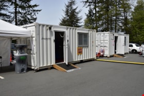
- Photograph of the COVID-19 drive thru testing site in Central Park parking lot in Burnaby. White shipping container buildings have been set up in the parking lot.
- Repository
- Burnaby Village Museum
- Collection/Fonds
- Burnaby Village Museum COVID-19 collection
- Description Level
- Item
- Physical Description
- 1 photograph (jpg)
- Scope and Content
- Photograph of the COVID-19 drive thru testing site in Central Park parking lot in Burnaby. White shipping container buildings have been set up in the parking lot.
- Subjects
- Advertising Medium - Signs and Signboards
- Geographic Features - Parks
- Public Services - Health Services
- Pandemics - COVID-19
- Geographic Access
- Central Park
- Imperial Street
- Accession Code
- BV021.2.48
- Access Restriction
- No restrictions
- Reproduction Restriction
- May be restricted by third party rights
- Date
- 5 Apr. 2020
- Media Type
- Photograph
- Historic Neighbourhood
- Central Park (Historic Neighbourhood)
- Planning Study Area
- Maywood Area
- Notes
- Title based on contents of photograph
Images
Signage for Burnaby's COVID-19 drive thru testing site
https://search.heritageburnaby.ca/link/museumdescription15370
- Repository
- Burnaby Village Museum
- Date
- 5 Apr. 2020
- Collection/Fonds
- Burnaby Village Museum COVID-19 collection
- Description Level
- Item
- Physical Description
- 1 photograph (jpg)
- Scope and Content
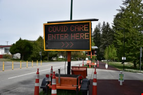
- Photograph of portable LED signage at entrance to COVID-19 drive thru test site in Central Park parking lot in Burnaby. LED sign reads "Covid Care Enter Here".
- Repository
- Burnaby Village Museum
- Collection/Fonds
- Burnaby Village Museum COVID-19 collection
- Description Level
- Item
- Physical Description
- 1 photograph (jpg)
- Scope and Content
- Photograph of portable LED signage at entrance to COVID-19 drive thru test site in Central Park parking lot in Burnaby. LED sign reads "Covid Care Enter Here".
- Subjects
- Advertising Medium - Signs and Signboards
- Geographic Features - Parks
- Public Services - Health Services
- Pandemics - COVID-19
- Geographic Access
- Central Park
- Imperial Street
- Accession Code
- BV021.2.35
- Access Restriction
- No restrictions
- Reproduction Restriction
- May be restricted by third party rights
- Date
- 5 Apr. 2020
- Media Type
- Photograph
- Historic Neighbourhood
- Central Park (Historic Neighbourhood)
- Planning Study Area
- Maywood Area
- Notes
- Title based on contents of photograph
Images
Signage for Burnaby's COVID-19 drive thru testing site
https://search.heritageburnaby.ca/link/museumdescription15371
- Repository
- Burnaby Village Museum
- Date
- 5 Apr. 2020
- Collection/Fonds
- Burnaby Village Museum COVID-19 collection
- Description Level
- Item
- Physical Description
- 1 photograph (jpg)
- Scope and Content
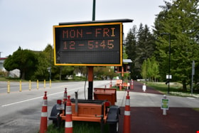
- Photograph of portable LED signage at entrance to COVID-19 drive thru testing site in Central Park parking lot in Burnaby. LED sign reads "Mon-Fri / 12-5:45".
- Repository
- Burnaby Village Museum
- Collection/Fonds
- Burnaby Village Museum COVID-19 collection
- Description Level
- Item
- Physical Description
- 1 photograph (jpg)
- Scope and Content
- Photograph of portable LED signage at entrance to COVID-19 drive thru testing site in Central Park parking lot in Burnaby. LED sign reads "Mon-Fri / 12-5:45".
- Subjects
- Advertising Medium - Signs and Signboards
- Geographic Features - Parks
- Public Services - Health Services
- Pandemics - COVID-19
- Geographic Access
- Central Park
- Imperial Street
- Accession Code
- BV021.2.36
- Access Restriction
- No restrictions
- Reproduction Restriction
- May be restricted by third party rights
- Date
- 5 Apr. 2020
- Media Type
- Photograph
- Historic Neighbourhood
- Central Park (Historic Neighbourhood)
- Planning Study Area
- Maywood Area
- Notes
- Title based on contents of photograph
Images
Signage for Burnaby's COVID-19 drive thru testing site
https://search.heritageburnaby.ca/link/museumdescription15372
- Repository
- Burnaby Village Museum
- Date
- 5 Apr. 2020
- Collection/Fonds
- Burnaby Village Museum COVID-19 collection
- Description Level
- Item
- Physical Description
- 1 photograph (jpg)
- Scope and Content
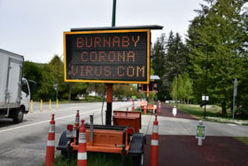
- Photograph of portable LED signage at entrance to COVID-19 drive thru testing site in Central Park parking lot in Burnaby. LED sign reads "Burnaby Corona Virus.Com"
- Repository
- Burnaby Village Museum
- Collection/Fonds
- Burnaby Village Museum COVID-19 collection
- Description Level
- Item
- Physical Description
- 1 photograph (jpg)
- Scope and Content
- Photograph of portable LED signage at entrance to COVID-19 drive thru testing site in Central Park parking lot in Burnaby. LED sign reads "Burnaby Corona Virus.Com"
- Subjects
- Advertising Medium - Signs and Signboards
- Geographic Features - Parks
- Public Services - Health Services
- Pandemics - COVID-19
- Geographic Access
- Central Park
- Imperial Street
- Accession Code
- BV021.2.37
- Access Restriction
- No restrictions
- Reproduction Restriction
- May be restricted by third party rights
- Date
- 5 Apr. 2020
- Media Type
- Photograph
- Historic Neighbourhood
- Central Park (Historic Neighbourhood)
- Planning Study Area
- Maywood Area
- Notes
- Title based on contents of photograph
Images
Signage for Burnaby's COVID-19 drive thru testing site
https://search.heritageburnaby.ca/link/museumdescription15373
- Repository
- Burnaby Village Museum
- Date
- 5 Apr. 2020
- Collection/Fonds
- Burnaby Village Museum COVID-19 collection
- Description Level
- Item
- Physical Description
- 1 photograph (jpg)
- Scope and Content
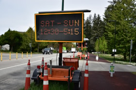
- Photograph of portable LED signage at entrance to COVID-19 drive thru testing site in Central Park parking lot in Burnaby. LED sign reads "Sat-Sun / 12:30-5:15".
- Repository
- Burnaby Village Museum
- Collection/Fonds
- Burnaby Village Museum COVID-19 collection
- Description Level
- Item
- Physical Description
- 1 photograph (jpg)
- Scope and Content
- Photograph of portable LED signage at entrance to COVID-19 drive thru testing site in Central Park parking lot in Burnaby. LED sign reads "Sat-Sun / 12:30-5:15".
- Subjects
- Advertising Medium - Signs and Signboards
- Geographic Features - Parks
- Public Services - Health Services
- Pandemics - COVID-19
- Geographic Access
- Central Park
- Imperial Street
- Accession Code
- BV021.2.38
- Access Restriction
- No restrictions
- Reproduction Restriction
- May be restricted by third party rights
- Date
- 5 Apr. 2020
- Media Type
- Photograph
- Historic Neighbourhood
- Central Park (Historic Neighbourhood)
- Planning Study Area
- Maywood Area
- Notes
- Title based on contents of photograph
Images
Intake of Burnaby's water supply
https://search.heritageburnaby.ca/link/museumdescription583
- Repository
- Burnaby Village Museum
- Date
- [190-?] (date of original), copied 1977
- Collection/Fonds
- Burnaby Village Museum Photograph collection
- Description Level
- Item
- Physical Description
- 1 photograph : b&w ; 20.2 x 25.2 cm print
- Scope and Content
- Photograph of a building by fast flowing stream. There are dense forests to both sides of the photograph, and mountains in the distance. Three men in suits and ties are standing by the house. The catalogue record identifies the photograph as "intake of Burnaby's water supply," and also notes "Bruce…
- Repository
- Burnaby Village Museum
- Collection/Fonds
- Burnaby Village Museum Photograph collection
- Description Level
- Item
- Physical Description
- 1 photograph : b&w ; 20.2 x 25.2 cm print
- Scope and Content
- Photograph of a building by fast flowing stream. There are dense forests to both sides of the photograph, and mountains in the distance. Three men in suits and ties are standing by the house. The catalogue record identifies the photograph as "intake of Burnaby's water supply," and also notes "Bruce Patterson took this picture."
- Accession Code
- HV977.99.25
- Access Restriction
- No restrictions
- Reproduction Restriction
- May be restricted by third party rights
- Date
- [190-?] (date of original), copied 1977
- Media Type
- Photograph
- Scan Resolution
- 600
- Scan Date
- 2023-07-18
- Photographer
- Patterson, Bruce
- Notes
- Title based on catalogue record
Images
Kingsway at Salisbury Avenue
https://search.heritageburnaby.ca/link/museumdescription3091
- Repository
- Burnaby Village Museum
- Date
- [1914]
- Collection/Fonds
- Burnaby Village Museum Photograph collection
- Description Level
- Item
- Physical Description
- 1 photograph : b&w glass negative ; 16.0 x 20.9 cm
- Scope and Content
- Photograph of Kingsway looking west from Salisbury Avenue in Burnaby. At one corner of the four-way intersection is a road sign labelling the roads "Kingsway" and "Salisbury Ave," beside which hangs a "For Sale" sign from "Wolf Merton & Son" for a house at "119 Pender St. W. Vancouver." Across fro…
- Repository
- Burnaby Village Museum
- Collection/Fonds
- Burnaby Village Museum Photograph collection
- Description Level
- Item
- Physical Description
- 1 photograph : b&w glass negative ; 16.0 x 20.9 cm
- Scope and Content
- Photograph of Kingsway looking west from Salisbury Avenue in Burnaby. At one corner of the four-way intersection is a road sign labelling the roads "Kingsway" and "Salisbury Ave," beside which hangs a "For Sale" sign from "Wolf Merton & Son" for a house at "119 Pender St. W. Vancouver." Across from these signs stands a man in a suit beside one of the electric poles that lines Kingsway. Further behind him is a water tower that an earlier catalogue record from 1988 identifies as a Municipal Water Tower. Also, the record dates the negative ca. 1914.
- Subjects
- Geographic Features - Roads
- Structures - Water Tanks and Towers
- Public Services - Utilities
- Geographic Access
- Kingsway
- Salisbury Avenue
- Accession Code
- HV972.11.5
- Access Restriction
- No restrictions
- Reproduction Restriction
- No known restrictions
- Date
- [1914]
- Media Type
- Photograph
- Historic Neighbourhood
- Edmonds (Historic Neighbourhood)
- Planning Study Area
- Stride Avenue Area
- Richmond Park Area
- Scan Resolution
- 300
- Scan Date
- 14/8/2006
- Scale
- 100
- Notes
- Title based on contents of photograph
- 1 b&w contact print accompanying negative
Images
Confederation Park's new playground
https://search.heritageburnaby.ca/link/museumdescription1088
- Repository
- Burnaby Village Museum
- Date
- 1927
- Collection/Fonds
- Burnaby Village Museum Photograph collection
- Description Level
- Item
- Physical Description
- 1 photograph : sepia ; 19 x 23.5 cm
- Scope and Content
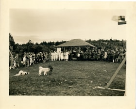
- Photograph of a large gathering of adults and children at Confederation Park for the opening ceremony for the new playground. A man on a pedestal is speaking and a crowd of people are surrounding him. There are six women in front of the gazebo wearing tags attached to the front of their dresses tha…
- Repository
- Burnaby Village Museum
- Collection/Fonds
- Burnaby Village Museum Photograph collection
- Description Level
- Item
- Physical Description
- 1 photograph : sepia ; 19 x 23.5 cm
- Scope and Content
- Photograph of a large gathering of adults and children at Confederation Park for the opening ceremony for the new playground. A man on a pedestal is speaking and a crowd of people are surrounding him. There are six women in front of the gazebo wearing tags attached to the front of their dresses that spell out "CANADA". There are three dogs in the foreground playing, and a Union Jack is flying in the upper right corner of the photograph.
- Subjects
- Recreational Devices - Playgrounds
- Geographic Features - Parks
- Persons - Crowds
- Events - Openings
- Geographic Access
- Confederation Park
- Willingdon Avenue
- Street Address
- 250 Willingdon Avenue
- Accession Code
- HV972.51.15
- Access Restriction
- No restrictions
- Reproduction Restriction
- No known restrictions
- Date
- 1927
- Media Type
- Photograph
- Historic Neighbourhood
- Capitol Hill (Historic Neighbourhood)
- Planning Study Area
- Capitol Hill Area
- Scan Resolution
- 600
- Scan Date
- 2023-04-04
- Photographer
- Charlton and Rathburn
- Notes
- Title based on contents of photograph
- Embossed inscription beneath photograph reads: "Charlton and Rathburn. / Vancouver. B.C."
- Handwritten inscription on verso of photograph reads: "Playground opening / Confederation Park / opening of Playground / Confederation Park / about 1927 / JCD on platform speaking"
- 1 b&w copy print accompanying
Images
The Lions from Burnaby Park
https://search.heritageburnaby.ca/link/museumdescription3109
- Repository
- Burnaby Village Museum
- Date
- [between 1926 and 1929]
- Collection/Fonds
- Burnaby Village Museum Photograph collection
- Description Level
- Item
- Physical Description
- 1 photograph : b&w photogravure ; 14.5 x 9.5 cm
- Scope and Content
- Photograph of the north shore mountains, including the Lions, taken from Robert Burnaby Park.
- Repository
- Burnaby Village Museum
- Collection/Fonds
- Burnaby Village Museum Photograph collection
- Description Level
- Item
- Physical Description
- 1 photograph : b&w photogravure ; 14.5 x 9.5 cm
- Scope and Content
- Photograph of the north shore mountains, including the Lions, taken from Robert Burnaby Park.
- Geographic Access
- Wedgewood Street
- Robert Burnaby Park
- Street Address
- 8155 Wedgewood Street
- Accession Code
- HV972.204.3
- Access Restriction
- No restrictions
- Reproduction Restriction
- No known restrictions
- Date
- [between 1926 and 1929]
- Media Type
- Photograph
- Historic Neighbourhood
- Burnaby Lake (Historic Neighbourhood)
- Planning Study Area
- Lakeview-Mayfield Area
- Related Material
- For other photographs from the same album, see HV972.204.3 - .14
- Scan Resolution
- 600
- Scan Date
- 2023-04-25
- Photographer
- Lloyd, Frank Ernest
- Notes
- Annotations made in white paint on recto of photograph read: "'The Lions' from Burnaby Park" and "Lloyd Studio, McKay."
Images
In the neighbourhood
https://search.heritageburnaby.ca/link/museumdescription1625
- Repository
- Burnaby Village Museum
- Date
- [194-] (date of original), copied 1976
- Collection/Fonds
- Burnaby Village Museum Photograph collection
- Description Level
- Item
- Physical Description
- 1 photograph : col. negative ; 4.5 x 6.5 cm
- Scope and Content
- Photograph of an elderly woman standing on a pavement sidewalk beside Regent Street. The tall house in the background is the McCallum house facing Regent Street, and other houses on the right side facing the road. There is an unpaved footpath closer to the houses. Electric poles are erected along t…
- Repository
- Burnaby Village Museum
- Collection/Fonds
- Burnaby Village Museum Photograph collection
- Description Level
- Item
- Physical Description
- 1 photograph : col. negative ; 4.5 x 6.5 cm
- Scope and Content
- Photograph of an elderly woman standing on a pavement sidewalk beside Regent Street. The tall house in the background is the McCallum house facing Regent Street, and other houses on the right side facing the road. There is an unpaved footpath closer to the houses. Electric poles are erected along the road on a grassy patch between the pavement sidewalk and the foot path.
- Subjects
- Geographic Features - Neighbourhoods
- Accession Code
- HV976.251.30
- Access Restriction
- No restrictions
- Reproduction Restriction
- May be restricted by third party rights
- Date
- [194-] (date of original), copied 1976
- Media Type
- Photograph
- Related Material
- For another photograph of the elderly lady, see HV976.251.28
- Scan Resolution
- 300
- Scan Date
- 22/8/2006
- Scale
- 100
- Notes
- Title based on contents of photograph
- The print is made as a black and white print from a colour negative film
Images
Snow scene at Edmonds
https://search.heritageburnaby.ca/link/museumdescription582
- Repository
- Burnaby Village Museum
- Date
- [190-?] (date of original), copied 1977
- Collection/Fonds
- Burnaby Village Museum Photograph collection
- Description Level
- Item
- Physical Description
- 1 photograph : b&w ; 20.2 x 25.2 cm print
- Scope and Content
- Photograph of a snow scene taken from the porch of the Patterson house on Edmonds Street. Noted in the catalogue record is how the snow covered house in the distance was the only neighbour of the Pattersons at that time. The house was originally located at 7260 Edmonds Street (near Kingsway). It w…
- Repository
- Burnaby Village Museum
- Collection/Fonds
- Burnaby Village Museum Photograph collection
- Description Level
- Item
- Physical Description
- 1 photograph : b&w ; 20.2 x 25.2 cm print
- Scope and Content
- Photograph of a snow scene taken from the porch of the Patterson house on Edmonds Street. Noted in the catalogue record is how the snow covered house in the distance was the only neighbour of the Pattersons at that time. The house was originally located at 7260 Edmonds Street (near Kingsway). It was relocated in 1955 to 7106 18th Avenue and is a city heritage site.
- Geographic Access
- Edmonds Street
- 18th Avenue
- Street Address
- 7260 Edmonds Street
- 7106 18th Avenue
- Accession Code
- HV977.99.24
- Access Restriction
- No restrictions
- Reproduction Restriction
- May be restricted by third party rights
- Date
- [190-?] (date of original), copied 1977
- Media Type
- Photograph
- Historic Neighbourhood
- Edmonds (Historic Neighbourhood)
- Planning Study Area
- Stride Avenue Area
- Scan Resolution
- 600
- Scan Date
- 2023-07-11
- Notes
- Title based on contents of photograph


![Intake of Burnaby's water supply, [190-?] (date of original), copied 1977 thumbnail](/media/hpo/_Data/_BVM_Images/1977/1977_0099_0025_001.jpg?width=280)
![Kingsway at Salisbury Avenue, [1914] thumbnail](/media/hpo/_Data/_BVM_Images/1971/197200110005.jpg?width=280)
![The Lions from Burnaby Park, [between 1926 and 1929] thumbnail](/media/hpo/_Data/_BVM_Images/1971/197202040003.jpg?width=280)
![In the neighbourhood, [194-] (date of original), copied 1976 thumbnail](/media/hpo/_Data/_BVM_Images/1974/197602510030.jpg?width=280)
![Snow scene at Edmonds, [190-?] (date of original), copied 1977 thumbnail](/media/hpo/_Data/_BVM_Images/1977/1977_0099_0024_001.jpg?width=280)