More like 'Interview with A.W. Dow by Larry R. Jensen November 11, 1974 - Track 5'
Narrow Results By
Subject
- Accidents - Automobile Accidents 1
- Adornment 1
- Advertising Medium 4
- Advertising Medium - Signs and Signboards 94
- Aerial Photographs
- Agricultural Tools and Equipment - Plows 3
- Agriculture 4
- Agriculture - Crops 2
- Agriculture - Dairy 1
- Agriculture - Farms
- Agriculture - Fruit and Berries 8
- Agriculture - Poultry 4
![Oakalla Prison farm, [195-] (date of original), copied 1985 thumbnail](/media/hpo/_Data/_Archives_Images/_Unrestricted/126/134-009.jpg?width=280)
Oakalla Prison farm
https://search.heritageburnaby.ca/link/archivedescription34793
- Repository
- City of Burnaby Archives
- Date
- [195-] (date of original), copied 1985
- Collection/Fonds
- Burnaby Historical Society fonds
- Description Level
- Item
- Physical Description
- 1 photograph : b&w ; 8.8 x 12.0 cm print
- Scope and Content
- Photograph of the exterior of farm buildings and the road to the equipment shed at Oakalla Prison Farm.
- Repository
- City of Burnaby Archives
- Date
- [195-] (date of original), copied 1985
- Collection/Fonds
- Burnaby Historical Society fonds
- Physical Description
- 1 photograph : b&w ; 8.8 x 12.0 cm print
- Description Level
- Item
- Record No.
- 134-009
- Access Restriction
- No restrictions
- Reproduction Restriction
- Reproduce for fair dealing purposes only
- Accession Number
- BHS1985-02
- Scope and Content
- Photograph of the exterior of farm buildings and the road to the equipment shed at Oakalla Prison Farm.
- Names
- Oakalla Prison Farm
- Media Type
- Photograph
- Notes
- Title based on contents of photograph
- Geographic Access
- Oakmount Crescent
- Street Address
- 5220 Oakmount Crescent
- Historic Neighbourhood
- Burnaby Lake (Historic Neighbourhood)
- Planning Study Area
- Oakalla Area
Images
![Oakalla Prison farm, [195-] (date of original), copied 1985 thumbnail](/media/hpo/_Data/_Archives_Images/_Unrestricted/126/134-009.jpg)
![Oakalla Prison Farm, [195-] (date of original), copied 1985 thumbnail](/media/hpo/_Data/_Archives_Images/_Unrestricted/126/134-012.jpg?width=280)
Oakalla Prison Farm
https://search.heritageburnaby.ca/link/archivedescription34796
- Repository
- City of Burnaby Archives
- Date
- [195-] (date of original), copied 1985
- Collection/Fonds
- Burnaby Historical Society fonds
- Description Level
- Item
- Physical Description
- 1 photograph : b&w ; 8.8 x 12.1 cm print
- Scope and Content
- Photograph of the exterior of farm buildings and the shop/repairs buildings at Oakalla Prison Farm.
- Repository
- City of Burnaby Archives
- Date
- [195-] (date of original), copied 1985
- Collection/Fonds
- Burnaby Historical Society fonds
- Physical Description
- 1 photograph : b&w ; 8.8 x 12.1 cm print
- Description Level
- Item
- Record No.
- 134-012
- Access Restriction
- No restrictions
- Reproduction Restriction
- Reproduce for fair dealing purposes only
- Accession Number
- BHS1985-02
- Scope and Content
- Photograph of the exterior of farm buildings and the shop/repairs buildings at Oakalla Prison Farm.
- Names
- Oakalla Prison Farm
- Media Type
- Photograph
- Notes
- Title based on contents of photograph
- Geographic Access
- Oakmount Crescent
- Street Address
- 5220 Oakmount Crescent
- Historic Neighbourhood
- Burnaby Lake (Historic Neighbourhood)
- Planning Study Area
- Oakalla Area
Images
![Oakalla Prison Farm, [195-] (date of original), copied 1985 thumbnail](/media/hpo/_Data/_Archives_Images/_Unrestricted/126/134-012.jpg)
![Oakalla Prison Farm, [195-] (date of original), copied 1985 thumbnail](/media/hpo/_Data/_Archives_Images/_Unrestricted/126/134-013.jpg?width=280)
Oakalla Prison Farm
https://search.heritageburnaby.ca/link/archivedescription34797
- Repository
- City of Burnaby Archives
- Date
- [195-] (date of original), copied 1985
- Collection/Fonds
- Burnaby Historical Society fonds
- Description Level
- Item
- Physical Description
- 1 photograph : b&w ; 8.8 x 12.6 cm print
- Scope and Content
- Photograph of the exterior of farm buildings and the equipment shed at Oakalla Prison Farm.
- Repository
- City of Burnaby Archives
- Date
- [195-] (date of original), copied 1985
- Collection/Fonds
- Burnaby Historical Society fonds
- Physical Description
- 1 photograph : b&w ; 8.8 x 12.6 cm print
- Description Level
- Item
- Record No.
- 134-013
- Access Restriction
- No restrictions
- Reproduction Restriction
- Reproduce for fair dealing purposes only
- Accession Number
- BHS1985-02
- Scope and Content
- Photograph of the exterior of farm buildings and the equipment shed at Oakalla Prison Farm.
- Names
- Oakalla Prison Farm
- Media Type
- Photograph
- Notes
- Title based on contents of photograph
- Geographic Access
- Oakmount Crescent
- Street Address
- 5220 Oakmount Crescent
- Historic Neighbourhood
- Burnaby Lake (Historic Neighbourhood)
- Planning Study Area
- Oakalla Area
Images
![Oakalla Prison Farm, [195-] (date of original), copied 1985 thumbnail](/media/hpo/_Data/_Archives_Images/_Unrestricted/126/134-013.jpg)
![Oakalla Prison Farm, [195-] (date of original), copied 1985 thumbnail](/media/hpo/_Data/_Archives_Images/_Unrestricted/126/134-015.jpg?width=280)
Oakalla Prison Farm
https://search.heritageburnaby.ca/link/archivedescription34799
- Repository
- City of Burnaby Archives
- Date
- [195-] (date of original), copied 1985
- Collection/Fonds
- Burnaby Historical Society fonds
- Description Level
- Item
- Physical Description
- 1 photograph : b&w ; 8.8 x 11.9 cm print
- Scope and Content
- Photograph of Oakalla Prison Farm taken from the main building and looking northeast.
- Repository
- City of Burnaby Archives
- Date
- [195-] (date of original), copied 1985
- Collection/Fonds
- Burnaby Historical Society fonds
- Physical Description
- 1 photograph : b&w ; 8.8 x 11.9 cm print
- Description Level
- Item
- Record No.
- 134-015
- Access Restriction
- No restrictions
- Reproduction Restriction
- Reproduce for fair dealing purposes only
- Accession Number
- BHS1985-02
- Scope and Content
- Photograph of Oakalla Prison Farm taken from the main building and looking northeast.
- Names
- Oakalla Prison Farm
- Media Type
- Photograph
- Notes
- Title based on contents of photograph
- Geographic Access
- Oakmount Crescent
- Street Address
- 5220 Oakmount Crescent
- Historic Neighbourhood
- Burnaby Lake (Historic Neighbourhood)
- Planning Study Area
- Oakalla Area
Images
![Oakalla Prison Farm, [195-] (date of original), copied 1985 thumbnail](/media/hpo/_Data/_Archives_Images/_Unrestricted/126/134-015.jpg)
![Oakalla Prison Farm, [195-] (date of original), copied 1985 thumbnail](/media/hpo/_Data/_Archives_Images/_Unrestricted/126/134-016.jpg?width=280)
Oakalla Prison Farm
https://search.heritageburnaby.ca/link/archivedescription34800
- Repository
- City of Burnaby Archives
- Date
- [195-] (date of original), copied 1985
- Collection/Fonds
- Burnaby Historical Society fonds
- Description Level
- Item
- Physical Description
- 1 photograph : b&w ; 8.8 x 12.0 cm
- Scope and Content
- Photograph of Oakalla Prison Farm taken from the main building and looking northeast. Deer Lake can be seen in the background.
- Repository
- City of Burnaby Archives
- Date
- [195-] (date of original), copied 1985
- Collection/Fonds
- Burnaby Historical Society fonds
- Physical Description
- 1 photograph : b&w ; 8.8 x 12.0 cm
- Description Level
- Item
- Record No.
- 134-016
- Access Restriction
- No restrictions
- Reproduction Restriction
- Reproduce for fair dealing purposes only
- Accession Number
- BHS1985-02
- Scope and Content
- Photograph of Oakalla Prison Farm taken from the main building and looking northeast. Deer Lake can be seen in the background.
- Subjects
- Agriculture - Farms
- Buildings - Public - Detention Facilities
- Geographic Features - Lakes and Ponds
- Names
- Oakalla Prison Farm
- Media Type
- Photograph
- Notes
- Title based on contents of photograph
- Geographic Access
- Deer Lake
- Oakmount Crescent
- Street Address
- 5220 Oakmount Crescent
- Historic Neighbourhood
- Burnaby Lake (Historic Neighbourhood)
- Planning Study Area
- Oakalla Area
Images
![Oakalla Prison Farm, [195-] (date of original), copied 1985 thumbnail](/media/hpo/_Data/_Archives_Images/_Unrestricted/126/134-016.jpg)
![Oakalla Prison Farm, [195-] (date of original), copied 1985 thumbnail](/media/hpo/_Data/_Archives_Images/_Unrestricted/126/134-017.jpg?width=280)
Oakalla Prison Farm
https://search.heritageburnaby.ca/link/archivedescription34801
- Repository
- City of Burnaby Archives
- Date
- [195-] (date of original), copied 1985
- Collection/Fonds
- Burnaby Historical Society fonds
- Description Level
- Item
- Physical Description
- 1 photograph : b&w ; 8.8 x 12.2 cm
- Scope and Content
- Photograph of Oakalla Prison Farm taken from the main building and looking southeast. Deer Lake can be seen in the background.
- Repository
- City of Burnaby Archives
- Date
- [195-] (date of original), copied 1985
- Collection/Fonds
- Burnaby Historical Society fonds
- Physical Description
- 1 photograph : b&w ; 8.8 x 12.2 cm
- Description Level
- Item
- Record No.
- 134-017
- Access Restriction
- No restrictions
- Reproduction Restriction
- Reproduce for fair dealing purposes only
- Accession Number
- BHS1985-02
- Scope and Content
- Photograph of Oakalla Prison Farm taken from the main building and looking southeast. Deer Lake can be seen in the background.
- Subjects
- Agriculture - Farms
- Buildings - Public - Detention Facilities
- Geographic Features - Lakes and Ponds
- Names
- Oakalla Prison Farm
- Media Type
- Photograph
- Notes
- Title based on contents of photograph
- Geographic Access
- Deer Lake
- Oakmount Crescent
- Street Address
- 5220 Oakmount Crescent
- Historic Neighbourhood
- Burnaby Lake (Historic Neighbourhood)
- Planning Study Area
- Oakalla Area
Images
![Oakalla Prison Farm, [195-] (date of original), copied 1985 thumbnail](/media/hpo/_Data/_Archives_Images/_Unrestricted/126/134-017.jpg)
![Oakalla Prison Farm, [195-] (date of original), copied 1985 thumbnail](/media/hpo/_Data/_Archives_Images/_Unrestricted/126/134-018.jpg?width=280)
Oakalla Prison Farm
https://search.heritageburnaby.ca/link/archivedescription34802
- Repository
- City of Burnaby Archives
- Date
- [195-] (date of original), copied 1985
- Collection/Fonds
- Burnaby Historical Society fonds
- Description Level
- Item
- Physical Description
- 1 photograph : b&w ; 8.8 x 12.0 cm
- Scope and Content
- Photograph of Oakalla Prison Farm taken from the main building and looking southeast. Deer Lake can be seen in the background.
- Repository
- City of Burnaby Archives
- Date
- [195-] (date of original), copied 1985
- Collection/Fonds
- Burnaby Historical Society fonds
- Physical Description
- 1 photograph : b&w ; 8.8 x 12.0 cm
- Description Level
- Item
- Record No.
- 134-018
- Access Restriction
- No restrictions
- Reproduction Restriction
- Reproduce for fair dealing purposes only
- Accession Number
- BHS1985-02
- Scope and Content
- Photograph of Oakalla Prison Farm taken from the main building and looking southeast. Deer Lake can be seen in the background.
- Subjects
- Agriculture - Farms
- Buildings - Public - Detention Facilities
- Geographic Features - Lakes and Ponds
- Names
- Oakalla Prison Farm
- Media Type
- Photograph
- Notes
- Title based on contents of photograph
- Geographic Access
- Deer Lake
- Oakmount Crescent
- Street Address
- 5220 Oakmount Crescent
- Historic Neighbourhood
- Burnaby Lake (Historic Neighbourhood)
- Planning Study Area
- Oakalla Area
Images
![Oakalla Prison Farm, [195-] (date of original), copied 1985 thumbnail](/media/hpo/_Data/_Archives_Images/_Unrestricted/126/134-018.jpg)
![Phillips Dairy Farm, [192-] (date of original), copied 1986 thumbnail](/media/hpo/_Data/_Archives_Images/_Unrestricted/204/204-519.jpg?width=280)
Phillips Dairy Farm
https://search.heritageburnaby.ca/link/archivedescription35661
- Repository
- City of Burnaby Archives
- Date
- [192-] (date of original), copied 1986
- Collection/Fonds
- Burnaby Historical Society fonds
- Description Level
- Item
- Physical Description
- 1 photograph : b&w ; 12.7 x 17.8 cm print
- Scope and Content
- Photograph of Phillips dairy farm at 515 Byrne Road (later renumbered 5670 Byrne Road). The dairy and barn are shown with Norman Phillips (son of John and Lily Phillips).
- Repository
- City of Burnaby Archives
- Date
- [192-] (date of original), copied 1986
- Collection/Fonds
- Burnaby Historical Society fonds
- Subseries
- Pioneer Tales subseries
- Physical Description
- 1 photograph : b&w ; 12.7 x 17.8 cm print
- Description Level
- Item
- Record No.
- 204-519
- Access Restriction
- No restrictions
- Reproduction Restriction
- No known restrictions
- Accession Number
- BHS1988-03
- Scope and Content
- Photograph of Phillips dairy farm at 515 Byrne Road (later renumbered 5670 Byrne Road). The dairy and barn are shown with Norman Phillips (son of John and Lily Phillips).
- Media Type
- Photograph
- Notes
- Title based on contents of photograph
- Geographic Access
- Byrne Road
- Street Address
- 5670 Byrne Road
- Historic Neighbourhood
- Fraser Arm (Historic Neighbourhood)
- Planning Study Area
- Big Bend Area
Images
![Phillips Dairy Farm, [192-] (date of original), copied 1986 thumbnail](/media/hpo/_Data/_Archives_Images/_Unrestricted/204/204-519.jpg)
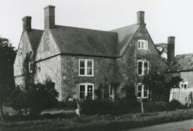
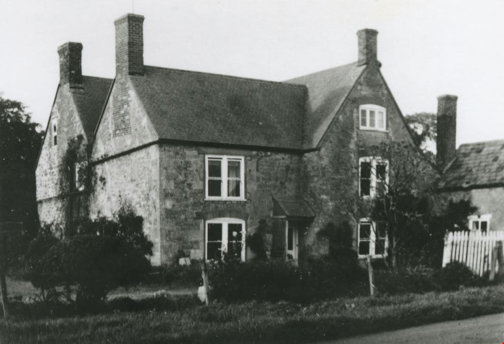
Rowborough Farm
https://search.heritageburnaby.ca/link/archivedescription36206
- Repository
- City of Burnaby Archives
- Date
- 1963
- Collection/Fonds
- Burnaby Historical Society fonds
- Description Level
- Item
- Physical Description
- 1 photograph : b&w ; 7.5 x 11.5 cm print
- Scope and Content
- Photograph of a very large stone building called the Rowborogh Farm, the Love family home in England.
- Repository
- City of Burnaby Archives
- Date
- 1963
- Collection/Fonds
- Burnaby Historical Society fonds
- Subseries
- Love family subseries
- Physical Description
- 1 photograph : b&w ; 7.5 x 11.5 cm print
- Description Level
- Item
- Record No.
- 232-003
- Access Restriction
- No restrictions
- Reproduction Restriction
- Reproduce for fair dealing purposes only
- Accession Number
- BHS1989-24
- Scope and Content
- Photograph of a very large stone building called the Rowborogh Farm, the Love family home in England.
- Media Type
- Photograph
- Notes
- Title based on contents of photograph
- 1 b&w copy negative accompanying
Images
![Sidney Roofing and Paper Company, [1960] thumbnail](/media/Hpo/_Data/_Archives_Images/_Unrestricted/001/091-001.jpg?width=280)
Sidney Roofing and Paper Company
https://search.heritageburnaby.ca/link/archivedescription34676
- Repository
- City of Burnaby Archives
- Date
- [1960]
- Collection/Fonds
- Burnaby Historical Society fonds
- Description Level
- Item
- Physical Description
- 1 photograph : b&w ; 20.2 x 25.7 cm mounted on cardboard
- Scope and Content
- Aerial photograph of Sidney Roofing and Paper Company located in South Burnaby.
- Repository
- City of Burnaby Archives
- Date
- [1960]
- Collection/Fonds
- Burnaby Historical Society fonds
- Subseries
- Photographs subseries
- Physical Description
- 1 photograph : b&w ; 20.2 x 25.7 cm mounted on cardboard
- Description Level
- Item
- Record No.
- 091-001
- Access Restriction
- No restrictions
- Reproduction Restriction
- Reproduce for fair dealing purposes only
- Accession Number
- BHS2007-04
- Scope and Content
- Aerial photograph of Sidney Roofing and Paper Company located in South Burnaby.
- Subjects
- Aerial Photographs
- Buildings - Industrial
- Media Type
- Photograph
- Photographer
- Graphic Industries Limited
- Notes
- Title based on contents of photograph
- Bottom of photo has the "Sidney Products" logo and reads, "Sidney Roofing & Paper Co. Ltd."
- Printed on back of cardboard "GIL: Graphic Industries Ltd. / Vancouver's Largest Commercial Photographers / 1201 Melville St., Vancouver 1, B.C. / Phone MUtual 1-4174 File No: 4601 3"
- Annotation on back of photograph reads, "[illegible of Sid R. in Burnaby looking N/W / June 5 '58"
- Historic Neighbourhood
- Fraser Arm (Historic Neighbourhood)
- Planning Study Area
- Big Bend Area
Images
![Sidney Roofing and Paper Company, [1960] thumbnail](/media/Hpo/_Data/_Archives_Images/_Unrestricted/001/091-001.jpg)
![Sidney Roofing and Paper Company, [1960] thumbnail](/media/Hpo/_Data/_Archives_Images/_Unrestricted/001/091-004.jpg?width=280)
Sidney Roofing and Paper Company
https://search.heritageburnaby.ca/link/archivedescription34679
- Repository
- City of Burnaby Archives
- Date
- [1960]
- Collection/Fonds
- Burnaby Historical Society fonds
- Description Level
- Item
- Physical Description
- 1 photograph : b&w ; 20.5 x 25.3 cm
- Scope and Content
- Aerial photograph of Sidney Roofing and Paper Company, South Burnaby.
- Repository
- City of Burnaby Archives
- Date
- [1960]
- Collection/Fonds
- Burnaby Historical Society fonds
- Subseries
- Photographs subseries
- Physical Description
- 1 photograph : b&w ; 20.5 x 25.3 cm
- Description Level
- Item
- Record No.
- 091-004
- Access Restriction
- No restrictions
- Reproduction Restriction
- Reproduce for fair dealing purposes only
- Accession Number
- BHS2007-04
- Scope and Content
- Aerial photograph of Sidney Roofing and Paper Company, South Burnaby.
- Media Type
- Photograph
- Photographer
- Graphic Industries Limited
- Notes
- Title based on contents of photograph
- Bottom of photo has the "Sidney Products" logo and reads, "Sidney Roofing & Paper Co. Ltd."
- Stamped on back of photograph: "Photo by: Graphic Industries Ltd. / File No. 3921-2 / Vancouver, Canada / PAcific 4174"
- Historic Neighbourhood
- Fraser Arm (Historic Neighbourhood)
- Planning Study Area
- Big Bend Area
Images
![Sidney Roofing and Paper Company, [1960] thumbnail](/media/Hpo/_Data/_Archives_Images/_Unrestricted/001/091-004.jpg)

Simon Fraser University
https://search.heritageburnaby.ca/link/archivedescription37404
- Repository
- City of Burnaby Archives
- Date
- 1970
- Collection/Fonds
- Burnaby Historical Society fonds
- Description Level
- Item
- Physical Description
- 1 photograph : col. postcard ; 9 x 14 cm
- Scope and Content
- Aerial photographic postcard of Simon Fraser University and Burnaby Mountain.
- Repository
- City of Burnaby Archives
- Date
- 1970
- Collection/Fonds
- Burnaby Historical Society fonds
- Subseries
- Robert Prittie subseries
- Physical Description
- 1 photograph : col. postcard ; 9 x 14 cm
- Description Level
- Item
- Record No.
- 369-003
- Access Restriction
- No restrictions
- Reproduction Restriction
- Reproduce for fair dealing purposes only
- Accession Number
- BHS1999-01
- Scope and Content
- Aerial photographic postcard of Simon Fraser University and Burnaby Mountain.
- Subjects
- Buildings - Schools - Universities and Colleges
- Aerial Photographs
- Documentary Artifacts - Postcards
- Names
- Simon Fraser University
- Media Type
- Photograph
- Photographer
- Thompson, Fred
- Notes
- Title based on contents of photograph.
- Geographic Access
- University Drive
- Street Address
- 8888 University Drive
- Planning Study Area
- Burnaby Mountain Area
Images


Simon Fraser University
https://search.heritageburnaby.ca/link/archivedescription37405
- Repository
- City of Burnaby Archives
- Date
- 1970
- Collection/Fonds
- Burnaby Historical Society fonds
- Description Level
- Item
- Physical Description
- 1 photograph : col. postcard ; 9 x 14 cm
- Scope and Content
- Aerial photographic postcard taken looking west over the parking lot and the Academic Quadrangle at Simon Fraser University.
- Repository
- City of Burnaby Archives
- Date
- 1970
- Collection/Fonds
- Burnaby Historical Society fonds
- Subseries
- Robert Prittie subseries
- Physical Description
- 1 photograph : col. postcard ; 9 x 14 cm
- Description Level
- Item
- Record No.
- 369-004
- Access Restriction
- No restrictions
- Reproduction Restriction
- Reproduce for fair dealing purposes only
- Accession Number
- BHS1999-01
- Scope and Content
- Aerial photographic postcard taken looking west over the parking lot and the Academic Quadrangle at Simon Fraser University.
- Subjects
- Aerial Photographs
- Buildings - Schools - Universities and Colleges
- Documentary Artifacts - Postcards
- Names
- Simon Fraser University
- Media Type
- Photograph
- Photographer
- Hildred, Chris
- Notes
- Title based on caption
- Geographic Access
- University Drive
- Street Address
- 8888 University Drive
- Planning Study Area
- Burnaby Mountain Area
Images

![Simon Fraser University, [1967 or 1968] (date of original), copied 1991 thumbnail](/media/hpo/_Data/_Archives_Images/_Unrestricted/370/370-811.jpg?width=280)
Simon Fraser University
https://search.heritageburnaby.ca/link/archivedescription38224
- Repository
- City of Burnaby Archives
- Date
- [1967 or 1968] (date of original), copied 1991
- Collection/Fonds
- Burnaby Historical Society fonds
- Description Level
- Item
- Physical Description
- 1 photograph : b&w ; 3.3 x 4.3 cm print on contact sheet 20.5 x 25.9 cm
- Scope and Content
- Aerial photograph of the Simon Fraser University (SFU) campus.
- Repository
- City of Burnaby Archives
- Date
- [1967 or 1968] (date of original), copied 1991
- Collection/Fonds
- Burnaby Historical Society fonds
- Subseries
- Burnaby Image Bank subseries
- Physical Description
- 1 photograph : b&w ; 3.3 x 4.3 cm print on contact sheet 20.5 x 25.9 cm
- Description Level
- Item
- Record No.
- 370-811
- Access Restriction
- No restrictions
- Reproduction Restriction
- No restrictions
- Accession Number
- BHS1999-03
- Scope and Content
- Aerial photograph of the Simon Fraser University (SFU) campus.
- Subjects
- Aerial Photographs
- Geographic Features - Mountains
- Buildings - Schools - Universities and Colleges
- Names
- Simon Fraser University
- Media Type
- Photograph
- Notes
- Title based on contents of photograph
- 1 b&w copy negative accompanying
- Copied from col. photograph
- Geographic Access
- Burnaby Mountain Conservation Area
- Planning Study Area
- Burnaby Mountain Area
Images
![Simon Fraser University, [1967 or 1968] (date of original), copied 1991 thumbnail](/media/hpo/_Data/_Archives_Images/_Unrestricted/370/370-811.jpg)
![Simon Fraser University, [1967] (date of original), copied 1991 thumbnail](/media/hpo/_Data/_Archives_Images/_Unrestricted/370/370-812.jpg?width=280)
Simon Fraser University
https://search.heritageburnaby.ca/link/archivedescription38225
- Repository
- City of Burnaby Archives
- Date
- [1967] (date of original), copied 1991
- Collection/Fonds
- Burnaby Historical Society fonds
- Description Level
- Item
- Physical Description
- 1 photograph : b&w ; 3.3 x 4.3 cm print on contact sheet 20.5 x 25.9 cm
- Scope and Content
- Aerial photograph of the Simon Fraser University (SFU) campus.
- Repository
- City of Burnaby Archives
- Date
- [1967] (date of original), copied 1991
- Collection/Fonds
- Burnaby Historical Society fonds
- Subseries
- Burnaby Image Bank subseries
- Physical Description
- 1 photograph : b&w ; 3.3 x 4.3 cm print on contact sheet 20.5 x 25.9 cm
- Description Level
- Item
- Record No.
- 370-812
- Access Restriction
- No restrictions
- Reproduction Restriction
- No restrictions
- Accession Number
- BHS1999-03
- Scope and Content
- Aerial photograph of the Simon Fraser University (SFU) campus.
- Names
- Simon Fraser University
- Media Type
- Photograph
- Notes
- Title based on contents of photograph
- 1 b&w copy negative accompanying
- Copied from col. photograph
- Geographic Access
- Burnaby Mountain Conservation Area
- University Drive
- Street Address
- 8888 University Drive
- Planning Study Area
- Burnaby Mountain Area
Images
![Simon Fraser University, [1967] (date of original), copied 1991 thumbnail](/media/hpo/_Data/_Archives_Images/_Unrestricted/370/370-812.jpg)

Simon Fraser University Buildings
https://search.heritageburnaby.ca/link/archivedescription37406
- Repository
- City of Burnaby Archives
- Date
- 1970
- Collection/Fonds
- Burnaby Historical Society fonds
- Description Level
- Item
- Physical Description
- 1 photograph : col. postcard ; 9 x 14 cm
- Scope and Content
- Photographic postcard taken looking north towards Simon Fraser University. The caption on the back of the postcard reads: "The aerial view shows part of the university buildings on Burnaby Mountain, with Burrard Inlet, Indian Arm and the North Shore Mountains in the background."
- Repository
- City of Burnaby Archives
- Date
- 1970
- Collection/Fonds
- Burnaby Historical Society fonds
- Subseries
- Robert Prittie subseries
- Physical Description
- 1 photograph : col. postcard ; 9 x 14 cm
- Description Level
- Item
- Record No.
- 369-005
- Access Restriction
- No restrictions
- Reproduction Restriction
- Reproduce for fair dealing purposes only
- Accession Number
- BHS1999-01
- Scope and Content
- Photographic postcard taken looking north towards Simon Fraser University. The caption on the back of the postcard reads: "The aerial view shows part of the university buildings on Burnaby Mountain, with Burrard Inlet, Indian Arm and the North Shore Mountains in the background."
- Subjects
- Aerial Photographs
- Buildings - Schools - Universities and Colleges
- Geographic Features - Mountains
- Documentary Artifacts - Postcards
- Names
- Simon Fraser University
- Media Type
- Photograph
- Notes
- Title based on caption
- Geographic Access
- University Drive
- Street Address
- 8888 University Drive
- Planning Study Area
- Burnaby Mountain Area
Images


Standard Oil Company
https://search.heritageburnaby.ca/link/archivedescription34567
- Repository
- City of Burnaby Archives
- Date
- 1958
- Collection/Fonds
- Burnaby Historical Society fonds
- Description Level
- Item
- Physical Description
- 1 photograph : b&w ; 28.0 x 35.8 cm
- Scope and Content
- Aerial photograph of the Standard Oil Company Stanovan Refinery storage and shipping area, along the Burrard Inlet.
- Repository
- City of Burnaby Archives
- Date
- 1958
- Collection/Fonds
- Burnaby Historical Society fonds
- Subseries
- Photographs subseries
- Physical Description
- 1 photograph : b&w ; 28.0 x 35.8 cm
- Description Level
- Item
- Record No.
- 052-003
- Access Restriction
- No restrictions
- Reproduction Restriction
- Reproduce for fair dealing purposes only
- Accession Number
- BHS2007-04
- Scope and Content
- Aerial photograph of the Standard Oil Company Stanovan Refinery storage and shipping area, along the Burrard Inlet.
- Media Type
- Photograph
- Notes
- Title based on contents of photograph
- Geographic Access
- Eton Street
- Street Address
- 4403 Eton Street
- Historic Neighbourhood
- Vancouver Heights (Historic Neighbourhood)
- Planning Study Area
- Burnaby Heights Area
Images


Standard Oil Company
https://search.heritageburnaby.ca/link/archivedescription34568
- Repository
- City of Burnaby Archives
- Date
- 1958
- Collection/Fonds
- Burnaby Historical Society fonds
- Description Level
- Item
- Physical Description
- 1 photograph : b&w ; 27.8 x 35.5 cm
- Scope and Content
- Aerial photograph of the Standard Oil Company Stanovan Refinery, Burrard Inlet.
- Repository
- City of Burnaby Archives
- Date
- 1958
- Collection/Fonds
- Burnaby Historical Society fonds
- Subseries
- Photographs subseries
- Physical Description
- 1 photograph : b&w ; 27.8 x 35.5 cm
- Description Level
- Item
- Record No.
- 052-004
- Access Restriction
- No restrictions
- Reproduction Restriction
- Reproduce for fair dealing purposes only
- Accession Number
- BHS2007-04
- Scope and Content
- Aerial photograph of the Standard Oil Company Stanovan Refinery, Burrard Inlet.
- Media Type
- Photograph
- Photographer
- Aero Surveys Limited
- Notes
- Title based on contents of photograph
- Back of photo stamped: "Photo by Aero Surveys Limited, Vancouver, BC, Canada / Identification No.: BO-58-444"
- Geographic Access
- Eton Street
- Street Address
- 4403 Eton Street
- Historic Neighbourhood
- Vancouver Heights (Historic Neighbourhood)
- Planning Study Area
- Burnaby Heights Area
Images

![Thrussell farm and barn, [1914] thumbnail](/media/hpo/_Data/_Archives_Images/_Unrestricted/251/275-009.jpg?width=280)
Thrussell farm and barn
https://search.heritageburnaby.ca/link/archivedescription36477
- Repository
- City of Burnaby Archives
- Date
- [1914]
- Collection/Fonds
- Burnaby Historical Society fonds
- Description Level
- Item
- Physical Description
- 1 photograph : b&w ; 8.5 x 12.5 cm print
- Scope and Content
- Photograph of the Thrussell family farm, including the front gate and barn on Marine Drive, at Nelson Avenue.
- Repository
- City of Burnaby Archives
- Date
- [1914]
- Collection/Fonds
- Burnaby Historical Society fonds
- Subseries
- Thrussell family subseries
- Physical Description
- 1 photograph : b&w ; 8.5 x 12.5 cm print
- Description Level
- Item
- Record No.
- 275-009
- Access Restriction
- No restrictions
- Reproduction Restriction
- No known restrictions
- Accession Number
- BHS1992-05
- Scope and Content
- Photograph of the Thrussell family farm, including the front gate and barn on Marine Drive, at Nelson Avenue.
- Names
- North Arm Dairy
- Media Type
- Photograph
- Notes
- Title based on contents of photograph
- Geographic Access
- Marine Drive
- Nelson Avenue
- Historic Neighbourhood
- Fraser Arm (Historic Neighbourhood)
- Planning Study Area
- Big Bend Area
Images
![Thrussell farm and barn, [1914] thumbnail](/media/hpo/_Data/_Archives_Images/_Unrestricted/251/275-009.jpg)
![Thrussell's farm, [1900] thumbnail](/media/hpo/_Data/_Archives_Images/_Unrestricted/251/275-001.jpg?width=280)
Thrussell's farm
https://search.heritageburnaby.ca/link/archivedescription36470
- Repository
- City of Burnaby Archives
- Date
- [1900]
- Collection/Fonds
- Burnaby Historical Society fonds
- Description Level
- Item
- Physical Description
- 1 photograph : b&w ; 8.5 x 12.5 cm print
- Scope and Content
- Photograph of the North Arm Dairy and the rest of the Thrussell family farm at Marine Drive and Nelson Avenue. Froggers Creek is visible on the left.
- Repository
- City of Burnaby Archives
- Date
- [1900]
- Collection/Fonds
- Burnaby Historical Society fonds
- Subseries
- Thrussell family subseries
- Physical Description
- 1 photograph : b&w ; 8.5 x 12.5 cm print
- Description Level
- Item
- Record No.
- 275-001
- Access Restriction
- No restrictions
- Reproduction Restriction
- No known restrictions
- Accession Number
- BHS1992-05
- Scope and Content
- Photograph of the North Arm Dairy and the rest of the Thrussell family farm at Marine Drive and Nelson Avenue. Froggers Creek is visible on the left.
- Names
- North Arm Dairy
- Media Type
- Photograph
- Notes
- Title based on contents of photograph
- Geographic Access
- Marine Drive
- Nelson Avenue
- Historic Neighbourhood
- Fraser Arm (Historic Neighbourhood)
- Planning Study Area
- Big Bend Area
Images
![Thrussell's farm, [1900] thumbnail](/media/hpo/_Data/_Archives_Images/_Unrestricted/251/275-001.jpg)