More like 'Habitat for Humanity Government St. project'
Narrow Results By
Subject
- Accidents - Automobile Accidents 1
- Adornment 30
- Adornment - Jewelry 1
- Adornment - Lapel Pins
- Advertising Medium 16
- Advertising Medium - Poster 2
- Advertising Medium - Signs and Signboards 110
- Aerial Photographs
- Agricultural Tools and Equipment 3
- Agricultural Tools and Equipment - Gardening Equipment 1
- Agricultural Tools and Equipment - Plows 3
- Agriculture 14
Person / Organization
- Alpha Secondary School 1
- Barnet Mill 1
- Burnaby General Hospital 1
- Cascade Drive-In Theatre 1
- Chinese Market Gardens 1
- Dominion Bridge Company 1
- Fair Haven 1
- Galbraith, Eleanor Lois 3
- George Derby Health Centre 1
- Girl Guides of Canada 11
- Imperial Order Daughters of the Empire 1
- Lenkurt Electric Company 1
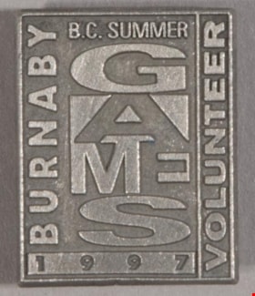
lapel pin
https://search.heritageburnaby.ca/link/museumartifact47239
- Repository
- Burnaby Village Museum
- Accession Code
- BV004.50.45
- Description
- Pin, vertical rectangle, grey metal with raised lettering and borders. At top, "B.C. SUMMER", then vertically arranged "GAMES" in wide letters in alternately positive and negative print, then "1997" at bottom in raised bar. "BURNABY" up left side, "VOLUNTEER" up right side, both perpendicular to other print. Back of pin is textured grey metal with post and butterfly clutch fastener. Post is set in round base with stop. Near edge of pin is "R" in circle, "ARTISS / REGINA / CANADA". Clutch is shiny silver metal with stamped "BALLOU REG'D / 130 YEARS".
- Object History
- The B.C. Games were established in 1977, and the first summer games were held in 1978. Commemorative pin for the 1997 B.C. Summer Games held in Burnaby [for volunteers].
- Category
- 08. Communication Artifacts
- Classification
- Documentary Artifacts - - Memorabilia
- Object Term
- Commemorative
- Marks/Labels
- Burnaby / B.C. Summer Games / Volunteer / 1997
- Colour
- Silver
- Measurements
- L: 2.2 cm x W: 1.8 cm
- Subjects
- Adornment
- Adornment - Lapel Pins
- Events - Competitions
- Personal Symbols - Pins
- Sports
- Persons - Volunteers
Images
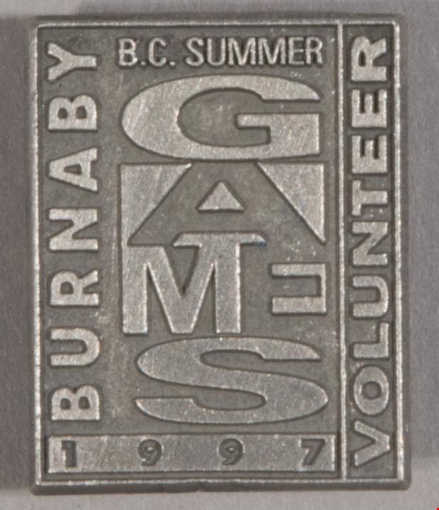
lapel pin
https://search.heritageburnaby.ca/link/museumartifact47240
- Repository
- Burnaby Village Museum
- Accession Code
- BV004.50.46
- Description
- Pin, vertical rectangle, grey metal with raised lettering and borders. At top, "B.C. SUMMER", then vertically arranged "GAMES" in wide letters in alternately positive and negative print, then "1997" at bottom in raised bar. "BURNABY" up left side, "VOLUNTEER" up right side, both perpendicular to other print. Back of pin is textured grey metal with post and butterfly clutch fastener. Post is set in round base with stop. Near edge of pin is "R" in circle, "ARTISS / REGINA / CANADA". Clutch is shiny silver metal with stamped "BALLOU REG'D / 130 YEARS".
- Object History
- The B.C. Games were established in 1977, and the first summer games were held in 1978. Commemorative pin for the 1997 B.C. Summer Games held in Burnaby [for volunteers].
- Category
- 08. Communication Artifacts
- Classification
- Documentary Artifacts - - Memorabilia
- Object Term
- Commemorative
- Marks/Labels
- Burnaby / B.C. Summer Games / Volunteer / 1997
- Colour
- Silver
- Measurements
- L: 2L: 2.2 cm x W: 1.8 cm
- Subjects
- Adornment
- Adornment - Lapel Pins
- Events - Competitions
- Personal Symbols - Pins
- Sports
- Persons - Volunteers
Images
![Cariboo Cloverleaf, Government Road and Gaglardi Way, [1978] thumbnail](/media/hpo/_Data/_Archives_Images/_Unrestricted/480/480-274.jpg?width=280)
Cariboo Cloverleaf, Government Road and Gaglardi Way
https://search.heritageburnaby.ca/link/archivedescription45379
- Repository
- City of Burnaby Archives
- Date
- [1978]
- Collection/Fonds
- Columbian Newspaper collection
- Description Level
- Item
- Physical Description
- 1 photograph : b&w ; 22.5 x 19 cm
- Scope and Content
- Aerial photograph of the Cariboo Cloverleaf, and the Government Road overpass construction that would join it with Gaglardi Way.
- Repository
- City of Burnaby Archives
- Date
- [1978]
- Collection/Fonds
- Columbian Newspaper collection
- Physical Description
- 1 photograph : b&w ; 22.5 x 19 cm
- Description Level
- Item
- Record No.
- 480-274
- Access Restriction
- No restrictions
- Reproduction Restriction
- No restrictions
- Accession Number
- 2003-02
- Scope and Content
- Aerial photograph of the Cariboo Cloverleaf, and the Government Road overpass construction that would join it with Gaglardi Way.
- Media Type
- Photograph
- Photographer
- King, Basil
- Notes
- Title based on contents of photograph
- Note on recto of photograph reads: "Cariboo cloverleaf in foreground and Government Road overpass construction (centre) will join with Gaglardi Way (top of pic)."
- Geographic Access
- Government Road
- Cariboo Road
- Gaglardi Way
- Historic Neighbourhood
- Burquitlam (Historic Neighbourhood)
- Planning Study Area
- Burnaby Lake Area
- Cariboo-Armstrong Area
- Cameron Area
Images
![Cariboo Cloverleaf, Government Road and Gaglardi Way, [1978] thumbnail](/media/hpo/_Data/_Archives_Images/_Unrestricted/480/480-274.jpg)

Road Construction
https://search.heritageburnaby.ca/link/archivedescription79978
- Repository
- City of Burnaby Archives
- Date
- September 20, 1976
- Collection/Fonds
- Burnaby Public Library Contemporary Visual Archive Project
- Description Level
- Item
- Physical Description
- 1 photograph : b&w ; 11 x 16 cm mounted on cardboard
- Scope and Content
- Photograph shows view of road construction on Broadway behind the Lake City Industrial Park.
- Repository
- City of Burnaby Archives
- Date
- September 20, 1976
- Collection/Fonds
- Burnaby Public Library Contemporary Visual Archive Project
- Physical Description
- 1 photograph : b&w ; 11 x 16 cm mounted on cardboard
- Description Level
- Item
- Record No.
- 556-534
- Access Restriction
- No restrictions
- Reproduction Restriction
- Reproduce for fair dealing purposes only
- Accession Number
- 2013-13
- Scope and Content
- Photograph shows view of road construction on Broadway behind the Lake City Industrial Park.
- Media Type
- Photograph
- Photographer
- Campbell, Peg
- Notes
- Scope note taken directly from BPL photograph description.
- 1 b&w copy negative : 10 x 12.5 cm accompanying
- Geographic Access
- Broadway
- Planning Study Area
- Lake City Area
Images


Stormont Overpass
https://search.heritageburnaby.ca/link/archivedescription45376
- Repository
- City of Burnaby Archives
- Date
- August 1978
- Collection/Fonds
- Columbian Newspaper collection
- Description Level
- Item
- Physical Description
- 1 photograph : b&w ; 12.5 x 24 cm
- Scope and Content
- Aerial photograph of Stormont Overpass which would provide a direct link from the Trans Canada Highway (previously named the 401 Freeway) to the Lougheed Highway and Simon Fraser University. This was taken when the excavation work was completed, and grading and paving still need to be done.
- Repository
- City of Burnaby Archives
- Date
- August 1978
- Collection/Fonds
- Columbian Newspaper collection
- Physical Description
- 1 photograph : b&w ; 12.5 x 24 cm
- Description Level
- Item
- Record No.
- 480-271
- Access Restriction
- No restrictions
- Reproduction Restriction
- No restrictions
- Accession Number
- 2003-02
- Scope and Content
- Aerial photograph of Stormont Overpass which would provide a direct link from the Trans Canada Highway (previously named the 401 Freeway) to the Lougheed Highway and Simon Fraser University. This was taken when the excavation work was completed, and grading and paving still need to be done.
- Media Type
- Photograph
- Photographer
- Hodge, Craig
- Notes
- Title based on contents of photograph
- Note in pencil on verso of photograph reads: "Altair Aviation / photo by / Craig Hodge"
- Geographic Access
- Cariboo Road
- Gaglardi Way
- Trans Canada Highway
- Historic Neighbourhood
- Burquitlam (Historic Neighbourhood)
- Planning Study Area
- Burnaby Lake Area
- Cameron Area
Images


Stormont Overpass
https://search.heritageburnaby.ca/link/archivedescription45377
- Repository
- City of Burnaby Archives
- Date
- August 1978
- Collection/Fonds
- Columbian Newspaper collection
- Description Level
- Item
- Physical Description
- 1 photograph : b&w ; 16.5 x 24 cm
- Scope and Content
- Aerial photograph of Stormont Overpass which would provide a direct link from the 401 Freeway to the Lougheed Highway and Simon Fraser University. This was taken when the excavation work was completed, and grading and paving still need to be done.
- Repository
- City of Burnaby Archives
- Date
- August 1978
- Collection/Fonds
- Columbian Newspaper collection
- Physical Description
- 1 photograph : b&w ; 16.5 x 24 cm
- Description Level
- Item
- Record No.
- 480-272
- Access Restriction
- No restrictions
- Reproduction Restriction
- No restrictions
- Accession Number
- 2003-02
- Scope and Content
- Aerial photograph of Stormont Overpass which would provide a direct link from the 401 Freeway to the Lougheed Highway and Simon Fraser University. This was taken when the excavation work was completed, and grading and paving still need to be done.
- Media Type
- Photograph
- Photographer
- Hodge, Craig
- Notes
- Title based on contents of photograph
- Newspaper clipping attached to verso of photograph reads: "After six years, work on the Stormont interchange in Burnaby is only a few weeks from completion. The huge clover-leaf junction of Gaglardi Way and the Freeway is on the top left-hand corner, with Gaglardi Way approaching from the bottom right where a bridge has been completed over the Burlington Northern tracks. An embankment linking that bridge with one over the Brunette River awaits only a layer of tarmac, and a path has been cleared through the woods to link up with the clover-leaf. The present access to the Freeway is along the road running from the left to right across the middle of the picture. The interchange will open next month."
- Note in pencil on verso of photograph reads: "Altair Aviation / photo by / Craig Hodge"
- Geographic Access
- Cariboo Road
- Gaglardi Way
- Trans Canada Highway
- Historic Neighbourhood
- Burquitlam (Historic Neighbourhood)
- Planning Study Area
- Burnaby Lake Area
- Cameron Area
Images

![Stormont Overpass, [1978] thumbnail](/media/hpo/_Data/_Archives_Images/_Unrestricted/480/480-275.jpg?width=280)
Stormont Overpass
https://search.heritageburnaby.ca/link/archivedescription45380
- Repository
- City of Burnaby Archives
- Date
- [1978]
- Collection/Fonds
- Columbian Newspaper collection
- Description Level
- Item
- Physical Description
- 1 photograph : b&w ; 16 x 24 cm
- Scope and Content
- Aerial photograph of Stormont Overpass which would provide a direct link from the Trans Canada Highway (previously named the 401 Freeway) to the Lougheed Highway and Simon Fraser University. This was taken when the excavation work was completed, and paving still need to be done.
- Repository
- City of Burnaby Archives
- Date
- [1978]
- Collection/Fonds
- Columbian Newspaper collection
- Physical Description
- 1 photograph : b&w ; 16 x 24 cm
- Description Level
- Item
- Record No.
- 480-275
- Access Restriction
- No restrictions
- Reproduction Restriction
- No restrictions
- Accession Number
- 2003-02
- Scope and Content
- Aerial photograph of Stormont Overpass which would provide a direct link from the Trans Canada Highway (previously named the 401 Freeway) to the Lougheed Highway and Simon Fraser University. This was taken when the excavation work was completed, and paving still need to be done.
- Media Type
- Photograph
- Photographer
- King, Basil
- Notes
- Title based on contents of photograph
- Note on verso of photograph reads: "One of the biggest Highways"
- Geographic Access
- Cariboo Road
- Gaglardi Way
- Trans Canada Highway
- Historic Neighbourhood
- Burquitlam (Historic Neighbourhood)
- Planning Study Area
- Burnaby Lake Area
- Cameron Area
Images
![Stormont Overpass, [1978] thumbnail](/media/hpo/_Data/_Archives_Images/_Unrestricted/480/480-275.jpg)

Burnaby Centre
https://search.heritageburnaby.ca/link/archivedescription79941
- Repository
- City of Burnaby Archives
- Date
- September 27, 1976
- Collection/Fonds
- Burnaby Public Library Contemporary Visual Archive Project
- Description Level
- Item
- Physical Description
- 1 photograph : b&w ; 11 x 16 cm mounted on cardboard
- Scope and Content
- Photograph shows an aerial view of Burnaby Centre looking east from Central Park Place. Kingsway is on the right and Grange Street is on the left.
- Repository
- City of Burnaby Archives
- Date
- September 27, 1976
- Collection/Fonds
- Burnaby Public Library Contemporary Visual Archive Project
- Physical Description
- 1 photograph : b&w ; 11 x 16 cm mounted on cardboard
- Description Level
- Item
- Record No.
- 556-512
- Access Restriction
- No restrictions
- Reproduction Restriction
- Reproduce for fair dealing purposes only
- Accession Number
- 2013-13
- Scope and Content
- Photograph shows an aerial view of Burnaby Centre looking east from Central Park Place. Kingsway is on the right and Grange Street is on the left.
- Media Type
- Photograph
- Photographer
- Norton, Paul
- Notes
- Scope note taken directly from BPL photograph description.
- 1 b&w copy negative : 10 x 12.5 cm accompanying
- Geographic Access
- Kingsway
- Grange Street
- Historic Neighbourhood
- Central Park (Historic Neighbourhood)
- Planning Study Area
- Maywood Area
Images


Construction on Acorn Avenue
https://search.heritageburnaby.ca/link/archivedescription79040
- Repository
- City of Burnaby Archives
- Date
- October 20, 1976
- Collection/Fonds
- Burnaby Public Library Contemporary Visual Archive Project
- Description Level
- Item
- Physical Description
- 1 photograph : b&w ; 11 x 16 cm mounted on cardboard
- Scope and Content
- Photograph shows a view from Hall Towers of houses and a high-rise under construction on Acorn Avenue.
- Repository
- City of Burnaby Archives
- Date
- October 20, 1976
- Collection/Fonds
- Burnaby Public Library Contemporary Visual Archive Project
- Physical Description
- 1 photograph : b&w ; 11 x 16 cm mounted on cardboard
- Description Level
- Item
- Record No.
- 556-108
- Access Restriction
- No restrictions
- Reproduction Restriction
- Reproduce for fair dealing purposes only
- Accession Number
- 2013-13
- Scope and Content
- Photograph shows a view from Hall Towers of houses and a high-rise under construction on Acorn Avenue.
- Media Type
- Photograph
- Photographer
- Ross, Martha
- Notes
- Scope note taken directly from BPL photograph description.
- 1 b&w copy negative : 10 x 12.5 cm accompanying
- Geographic Access
- Acorn Avenue
- Historic Neighbourhood
- Edmonds (Historic Neighbourhood)
- Planning Study Area
- Stride Avenue Area
Images

![The Fair Haven, [between 1950 and 1957] thumbnail](/media/Hpo/_Data/_Archives_Images/_Unrestricted/251/305-001.jpg?width=280)
The Fair Haven
https://search.heritageburnaby.ca/link/archivedescription36597
- Repository
- City of Burnaby Archives
- Date
- [between 1950 and 1957]
- Collection/Fonds
- Burnaby Historical Society fonds
- Description Level
- Item
- Physical Description
- 1 photograph : col. postcard ; 9 x 14 cm
- Scope and Content
- Aerial photographic postcard of "the Fair Haven," a group of United Church homes for Senior Citizens. The road in the foreground is Rumble Street, and the long road to the right is Sussex Avenue. The small forest behind "the Fair Haven" is the David Gary Park.
- Repository
- City of Burnaby Archives
- Date
- [between 1950 and 1957]
- Collection/Fonds
- Burnaby Historical Society fonds
- Subseries
- Vera Jackson Pel subseries
- Physical Description
- 1 photograph : col. postcard ; 9 x 14 cm
- Description Level
- Item
- Record No.
- 305-001
- Access Restriction
- No restrictions
- Reproduction Restriction
- Reproduce for fair dealing purposes only
- Accession Number
- BHS1992-46
- Scope and Content
- Aerial photographic postcard of "the Fair Haven," a group of United Church homes for Senior Citizens. The road in the foreground is Rumble Street, and the long road to the right is Sussex Avenue. The small forest behind "the Fair Haven" is the David Gary Park.
- Subjects
- Aerial Photographs
- Documentary Artifacts - Postcards
- Buildings - Residential - Seniors Housing
- Names
- Fair Haven
- Media Type
- Photograph
- Notes
- Typewritten note on verso of postcard reads: "AERIAL VIEW/ 'The Fairhaven', Burnaby BC / United Church Homes for Senior Citizens / 4341 Rumble St., Burnaby, BC"
- Handwritten note on verso of postcard reads: ""The road in the foreground is Rumble Street. The long road to the right is Sussex Avenue. The road, going up, on the left, barely visible is McKay Avenue = lower corner. Behind Fair Haven is the future David Gary Park cleared in the late 1950's - then more trees were felled in October 1962 with Hurricane Freda (blown over, uprooted trees) that left the park as it is today in 1993. The top row of little (5) white cottages were moved from the N.W. corner of Willingdon and Kingsway where Old Orchard Mall is now - they were part of Old Orchard Auto Villas, the first Fair Havens. Note: All cottages on right side of Lodge have been moved to Vancouver Island in 1991 for Motel units - by barge."
- Printed on verso of postcard: "Traveltime product, made in Vancouver, Canada, by Grant-Mann Lithographers Ltd."
- Geographic Access
- Rumble Street
- Street Address
- 4341 Rumble Street
- Historic Neighbourhood
- Alta-Vista (Historic Neighbourhood)
- Planning Study Area
- Sussex-Nelson Area
Images
![The Fair Haven, [between 1950 and 1957] thumbnail](/media/Hpo/_Data/_Archives_Images/_Unrestricted/251/305-001.jpg)

Lougheed Highway
https://search.heritageburnaby.ca/link/archivedescription79939
- Repository
- City of Burnaby Archives
- Date
- September 27, 1976
- Collection/Fonds
- Burnaby Public Library Contemporary Visual Archive Project
- Description Level
- Item
- Physical Description
- 1 photograph : b&w ; 11 x 16 cm mounted on cardboard
- Scope and Content
- Photograph shows an aerial view of Lougheed Highway looking southeast from Salish Court Tower west.
- Repository
- City of Burnaby Archives
- Date
- September 27, 1976
- Collection/Fonds
- Burnaby Public Library Contemporary Visual Archive Project
- Physical Description
- 1 photograph : b&w ; 11 x 16 cm mounted on cardboard
- Description Level
- Item
- Record No.
- 556-510
- Access Restriction
- No restrictions
- Reproduction Restriction
- Reproduce for fair dealing purposes only
- Accession Number
- 2013-13
- Scope and Content
- Photograph shows an aerial view of Lougheed Highway looking southeast from Salish Court Tower west.
- Media Type
- Photograph
- Photographer
- Campbell, Peg
- Notes
- Scope note taken directly from BPL photograph description.
- 1 b&w copy negative : 10 x 12.5 cm accompanying
- Geographic Access
- Lougheed Highway
- Historic Neighbourhood
- Burquitlam (Historic Neighbourhood)
- Planning Study Area
- Cameron Area
Images


Lougheed Highway
https://search.heritageburnaby.ca/link/archivedescription79940
- Repository
- City of Burnaby Archives
- Date
- July, 1976
- Collection/Fonds
- Burnaby Public Library Contemporary Visual Archive Project
- Description Level
- Item
- Physical Description
- 1 photograph : b&w ; 11 x 16 cm mounted on cardboard
- Scope and Content
- Photograph shows an aerial view looking east along Lougheed Highway at Salish Court Towers with the Cariboo Shopping Centre in the background.
- Repository
- City of Burnaby Archives
- Date
- July, 1976
- Collection/Fonds
- Burnaby Public Library Contemporary Visual Archive Project
- Physical Description
- 1 photograph : b&w ; 11 x 16 cm mounted on cardboard
- Description Level
- Item
- Record No.
- 556-511
- Access Restriction
- No restrictions
- Reproduction Restriction
- Reproduce for fair dealing purposes only
- Accession Number
- 2013-13
- Scope and Content
- Photograph shows an aerial view looking east along Lougheed Highway at Salish Court Towers with the Cariboo Shopping Centre in the background.
- Media Type
- Photograph
- Photographer
- Gardiner, Robert
- Notes
- Scope note taken directly from BPL photograph description.
- 1 b&w copy negative : 10 x 12.5 cm accompanying
- Geographic Access
- Lougheed Highway
- Historic Neighbourhood
- Burquitlam (Historic Neighbourhood)
- Planning Study Area
- Cameron Area
Images


Vantage Point Highrise
https://search.heritageburnaby.ca/link/archivedescription79942
- Repository
- City of Burnaby Archives
- Date
- October, 1976
- Collection/Fonds
- Burnaby Public Library Contemporary Visual Archive Project
- Description Level
- Item
- Physical Description
- 1 photograph : b&w ; 11 x 16 cm mounted on cardboard
- Scope and Content
- Photograph shows a view of Vantage Point Highrise at Lougheed Highway and Bellwood Avenue with Trans-Cold Refrigeration on Douglas Road in the foreground.
- Repository
- City of Burnaby Archives
- Date
- October, 1976
- Collection/Fonds
- Burnaby Public Library Contemporary Visual Archive Project
- Physical Description
- 1 photograph : b&w ; 11 x 16 cm mounted on cardboard
- Description Level
- Item
- Record No.
- 556-513
- Access Restriction
- No restrictions
- Reproduction Restriction
- Reproduce for fair dealing purposes only
- Accession Number
- 2013-13
- Scope and Content
- Photograph shows a view of Vantage Point Highrise at Lougheed Highway and Bellwood Avenue with Trans-Cold Refrigeration on Douglas Road in the foreground.
- Media Type
- Photograph
- Photographer
- Salmon, Stu
- Notes
- Scope note taken directly from BPL photograph description.
- 1 b&w copy negative : 10 x 12.5 cm accompanying
- Planning Study Area
- Dawson-Delta Area
Images

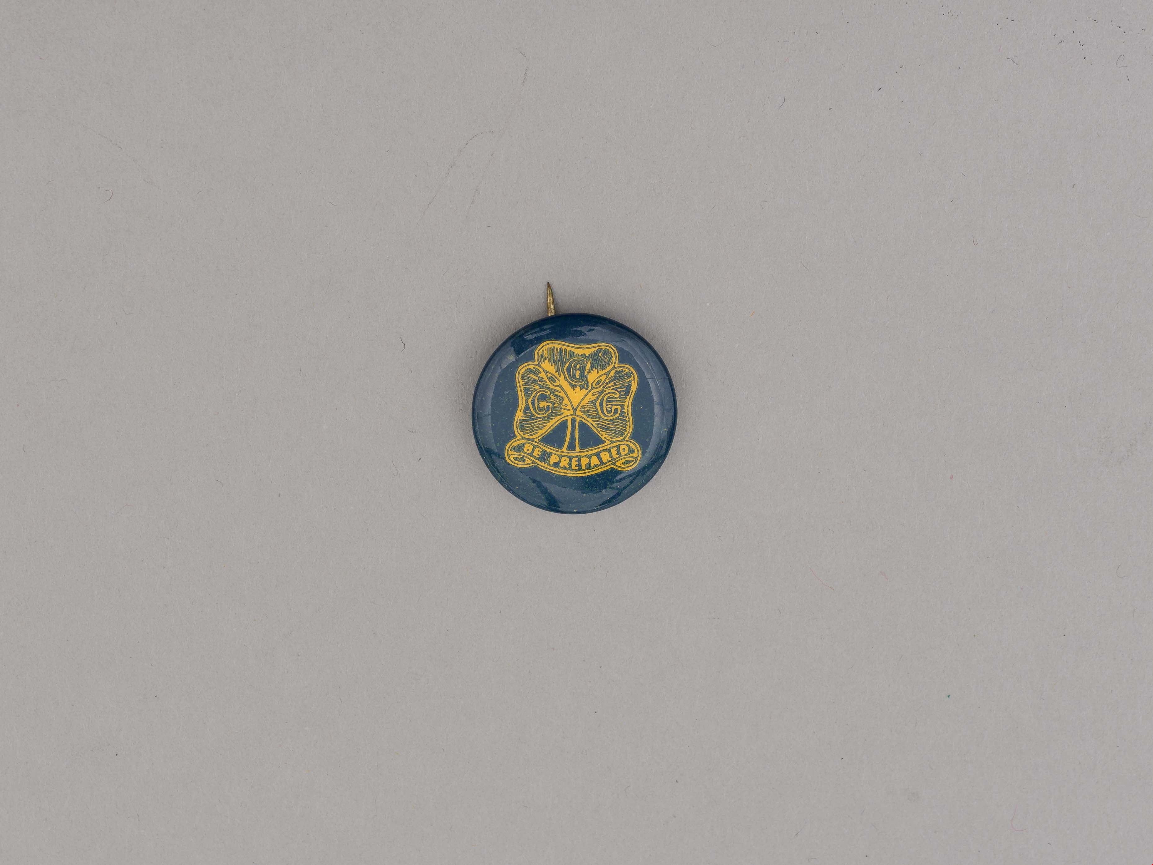
button pin
https://search.heritageburnaby.ca/link/museumartifact87602
- Repository
- Burnaby Village Museum
- Accession Code
- BV015.35.143
- Description
- button pin, Girl Guides; dark teal and yellow; Enrolment Pin; used in early 1940's when brass pins were unavailable; paper label on back reads: "MADE BY / Manitoba Stencil / and / Stamp Works / Winnipeg".
- Reference
- http://www.girlguides.ca/WEB/Documents/ON/Archives/Guide%20Badges%20A%20to%20G%20v3.pdf
- Category
- 03. Personal Artifacts
- Classification
- Adornment
- Personal Symbols
- Personal Symbols - - Personal Identification
- Personal Symbols - - Status Symbols
- Country Made
- Canada
- Province Made
- Manitoba
- Site/City Made
- Winnipeg
- Subjects
- Adornment
- Adornment - Lapel Pins
- Personal Symbols - Pins
- Organizations
- Organizations - Girls' Societies and Clubs
- Names
- Girl Guides of Canada
Images
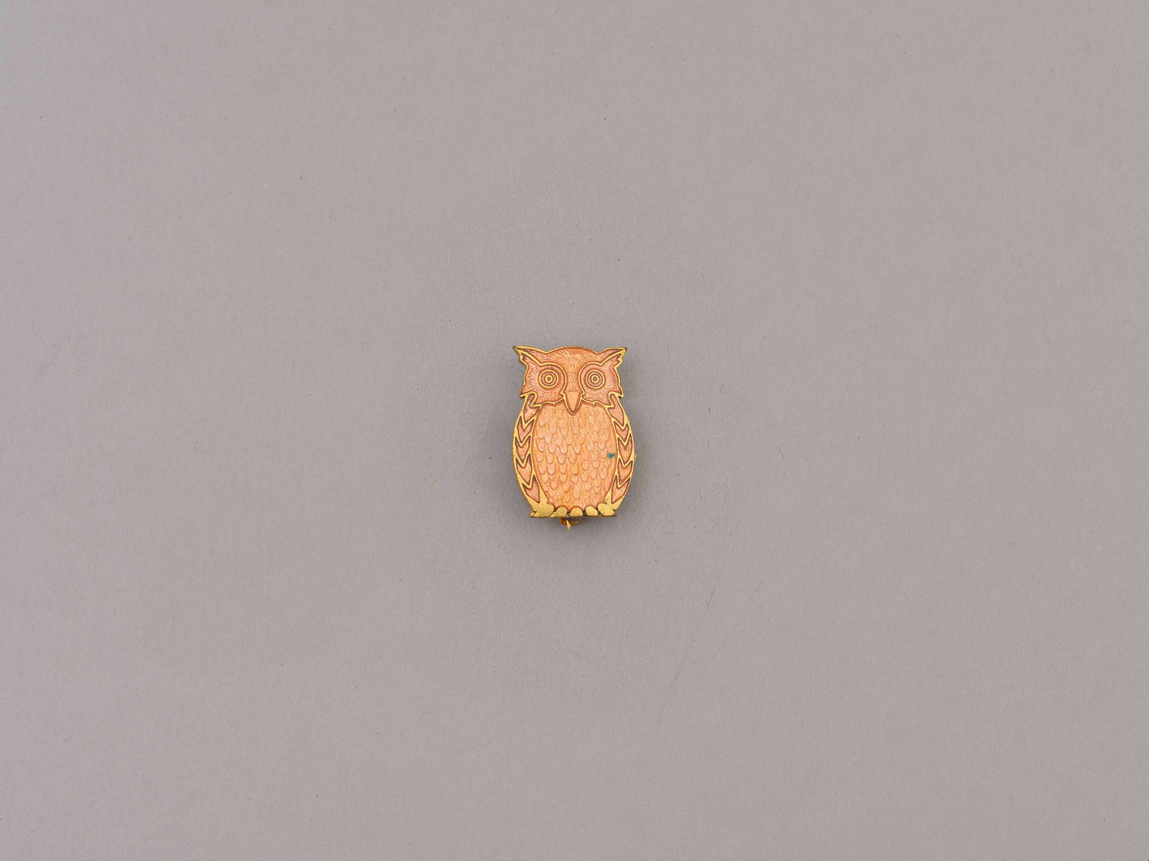
lapel pin
https://search.heritageburnaby.ca/link/museumartifact87592
- Repository
- Burnaby Village Museum
- Accession Code
- BV015.35.133
- Description
- lapel pin, Brownie; enameled brass owl with safety clasp back; Tawny Owl Appointment Pin.
- Reference
- http://www.girlguides.ca/WEB/Documents/ON/Archives/Insignia_Unit_Guiders.pdf
- Category
- 03. Personal Artifacts
- Classification
- Adornment
- Personal Symbols
- Personal Symbols - - Personal Identification
- Personal Symbols - - Status Symbols
- Subjects
- Adornment
- Adornment - Lapel Pins
- Personal Symbols - Pins
- Organizations
- Organizations - Girls' Societies and Clubs
Images
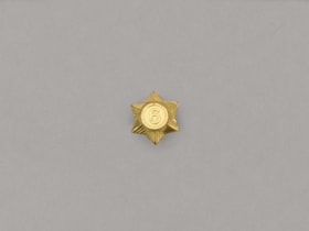
lapel pin
https://search.heritageburnaby.ca/link/museumartifact87593
- Repository
- Burnaby Village Museum
- Accession Code
- BV015.35.134
- Description
- Pin, six-pointed star with '6' at centre; six-year Service Star; post back; (1968) all branches and guiders (not commissioners) wore a single star with numeral denoting total service in all levels. No felt background.
- Reference
- http://www.girlguides.ca/WEB/Documents/ON/Archives/Service_stars.pdf
- Category
- 03. Personal Artifacts
- Classification
- Adornment
- Personal Symbols
- Personal Symbols - - Personal Identification
- Personal Symbols - - Status Symbols
- Subjects
- Adornment
- Adornment - Lapel Pins
- Personal Symbols - Pins
- Organizations
- Organizations - Girls' Societies and Clubs
- Names
- Girl Guides of Canada
Images

lapel pin
https://search.heritageburnaby.ca/link/museumartifact87594
- Repository
- Burnaby Village Museum
- Accession Code
- BV015.35.135
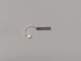
- Description
- pin, Girl Guides; Long Service Bar and Numerals; silver with text "LONG SERVICE"; safety clasp; worn with silver chain with number "25" at one end; safety clasp; end of chain attaches to long service bar.
- Reference
- http://www.girlguides.ca/web/Documents/ON/Archives/Honours_Awards.pdf
- Category
- 03. Personal Artifacts
- Classification
- Adornment
- Personal Symbols
- Personal Symbols - - Personal Identification
- Personal Symbols - - Status Symbols
- Subjects
- Adornment
- Adornment - Lapel Pins
- Personal Symbols - Pins
- Organizations
- Organizations - Girls' Societies and Clubs
- Names
- Girl Guides of Canada
Images

lapel pin
https://search.heritageburnaby.ca/link/museumartifact87595
- Repository
- Burnaby Village Museum
- Accession Code
- BV015.35.136
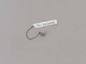
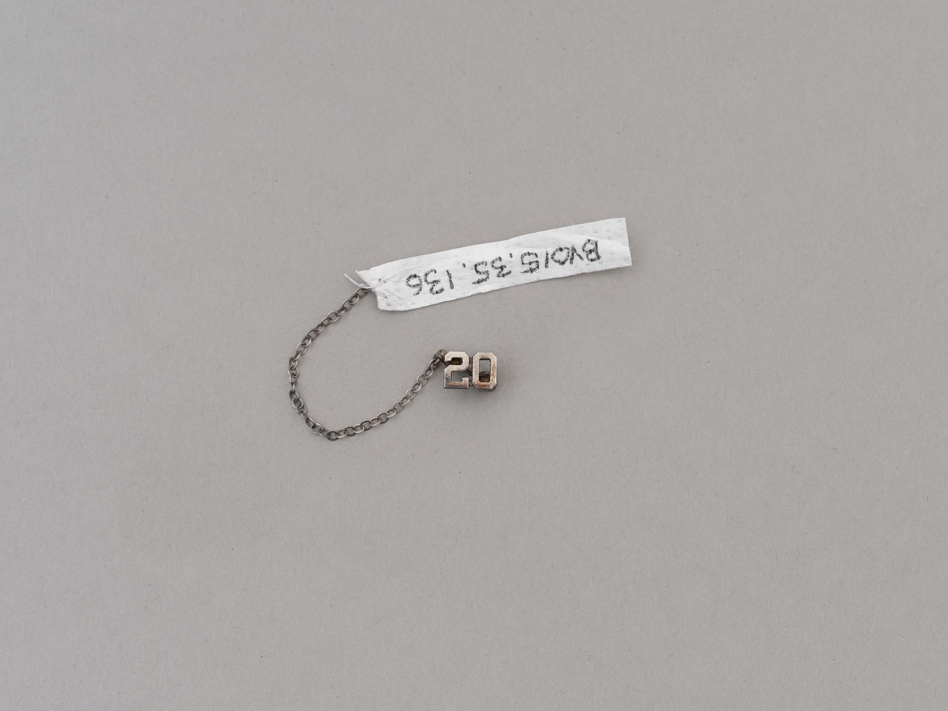
- Description
- pin, Girl Guides; Long Service Bar Numerals; silver chain with number "20" at one end; safety clasp; end of chain attaches to long service bar.
- Reference
- http://www.girlguides.ca/web/Documents/ON/Archives/Honours_Awards.pdf
- Category
- 03. Personal Artifacts
- Classification
- Adornment
- Personal Symbols
- Personal Symbols - - Personal Identification
- Personal Symbols - - Status Symbols
- Subjects
- Adornment
- Adornment - Lapel Pins
- Personal Symbols - Pins
- Organizations
- Organizations - Girls' Societies and Clubs
- Names
- Girl Guides of Canada
Images
lapel pin
https://search.heritageburnaby.ca/link/museumartifact87596
- Repository
- Burnaby Village Museum
- Accession Code
- BV015.35.137
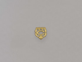
- Description
- lapel pin, Girl Guides and Rangers; Guide/Ranger Lieutenant Appointment Pin (brass "C" and "W" for Captain's Warrant and trefoil at bottom); safety clasp.
- Reference
- http://www.girlguides.ca/WEB/Documents/ON/Archives/Insignia_Unit_Guiders.pdf
- Category
- 03. Personal Artifacts
- Classification
- Adornment
- Personal Symbols
- Personal Symbols - - Personal Identification
- Personal Symbols - - Status Symbols
- Subjects
- Adornment
- Adornment - Lapel Pins
- Personal Symbols - Pins
- Organizations
- Organizations - Girls' Societies and Clubs
- Names
- Girl Guides of Canada
Images

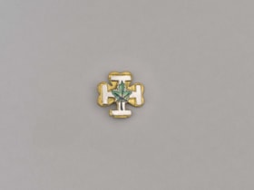
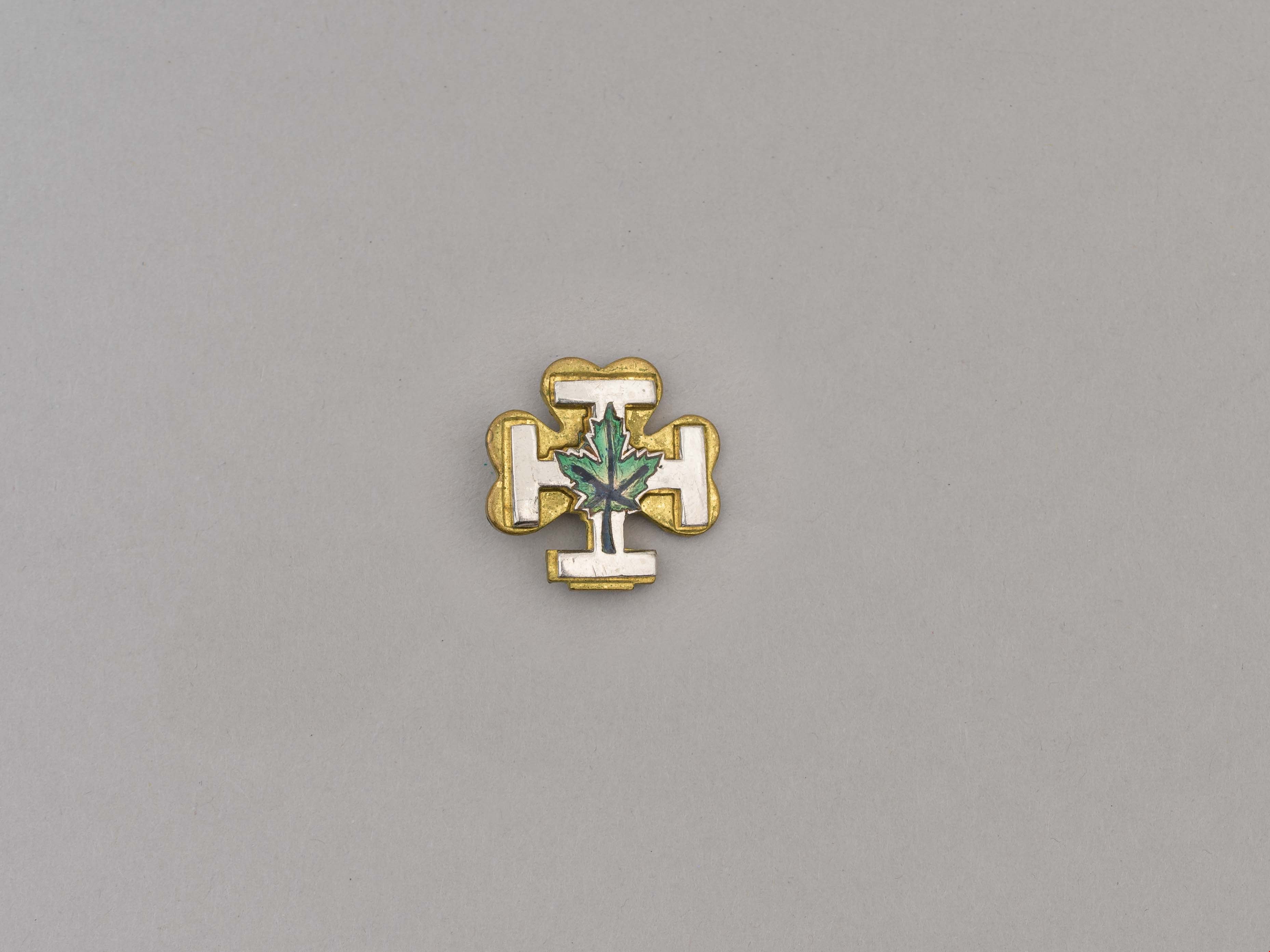
lapel pin
https://search.heritageburnaby.ca/link/museumartifact87597
- Repository
- Burnaby Village Museum
- Accession Code
- BV015.35.138
- Description
- lapel pin, Girl Guides; brass trefoil with silver patent cross and green enamelled maple leaf on top; safety clasp.
- Category
- 03. Personal Artifacts
- Classification
- Adornment
- Personal Symbols
- Personal Symbols - - Personal Identification
- Personal Symbols - - Status Symbols
- Subjects
- Adornment
- Adornment - Lapel Pins
- Personal Symbols - Pins
- Organizations
- Organizations - Girls' Societies and Clubs
- Names
- Girl Guides of Canada
Images