More like 'Gaglardi Way motor vehicle accident'
Narrow Results By
Subject
- Academic Disciplines 1
- Accidents 15
- Accidents - Automobile Accidents 30
- Accidents - Train Accidents
- Adornment 3
- Adornment - Jewelry 2
- Adornment - Lapel Pins 4
- Advertising Medium 1
- Advertising Medium - Signs and Signboards
- Aerial Photographs 36
- Agricultural Tools and Equipment 11
- Agricultural Tools and Equipment - Gardening Equipment 7
Person / Organization
- Admiral Hotel 1
- Battersby, Frank 1
- British Columbia Auto Company 1
- Burnaby Art Gallery 1
- Burnaby Players 1
- Canadian National Railway 4
- Canadian Pacific Railway Company 2
- Farmer, Joanne 6
- Great Northern Railway 5
- Hardman, Jack 1
- Hawkshaw, Richard Crichton Gilliland "Crichton" 1
- Hickman, Alfred "Alf" 1
![Collision, [194-] thumbnail](/media/hpo/_Data/_Archives_Images/_Unrestricted/513/521-016.jpg?width=280)
Collision
https://search.heritageburnaby.ca/link/archivedescription65783
- Repository
- City of Burnaby Archives
- Date
- [194-]
- Collection/Fonds
- Field family fonds
- Description Level
- Item
- Physical Description
- 1 photograph (tiff) ; 600 ppi
- Scope and Content
- Photograph of spectators surrounding a collision involving a British Columbia Electric Railway tram and a car.
- Repository
- City of Burnaby Archives
- Date
- [194-]
- Collection/Fonds
- Field family fonds
- Physical Description
- 1 photograph (tiff) ; 600 ppi
- Material Details
- Item is a scan of a faded sepia photograph
- Description Level
- Item
- Record No.
- 521-016
- Access Restriction
- No restrictions
- Reproduction Restriction
- Reproduce for fair dealing purposes only
- Accession Number
- 2010-14
- Scope and Content
- Photograph of spectators surrounding a collision involving a British Columbia Electric Railway tram and a car.
- Media Type
- Photograph
- Notes
- Title based on contents of photograph
Images
![Collision, [194-] thumbnail](/media/hpo/_Data/_Archives_Images/_Unrestricted/513/521-016.jpg)
![Collision, [194-] thumbnail](/media/hpo/_Data/_Archives_Images/_Unrestricted/513/521-017.jpg?width=280)
Collision
https://search.heritageburnaby.ca/link/archivedescription65784
- Repository
- City of Burnaby Archives
- Date
- [194-]
- Collection/Fonds
- Field family fonds
- Description Level
- Item
- Physical Description
- 1 photograph (tiff) ; 600 ppi
- Scope and Content
- Photograph of a car and the damage it suffered in a collision involving a British Columbia Electric Railway tram.
- Repository
- City of Burnaby Archives
- Date
- [194-]
- Collection/Fonds
- Field family fonds
- Physical Description
- 1 photograph (tiff) ; 600 ppi
- Material Details
- Item is a scan of a b&w photograph
- Description Level
- Item
- Record No.
- 521-017
- Access Restriction
- No restrictions
- Reproduction Restriction
- Reproduce for fair dealing purposes only
- Accession Number
- 2010-14
- Scope and Content
- Photograph of a car and the damage it suffered in a collision involving a British Columbia Electric Railway tram.
- Media Type
- Photograph
- Notes
- Title based on contents of photograph
Images
![Collision, [194-] thumbnail](/media/hpo/_Data/_Archives_Images/_Unrestricted/513/521-017.jpg)

Central Park testing station
https://search.heritageburnaby.ca/link/archivedescription95101
- Repository
- City of Burnaby Archives
- Date
- May 9, 2020
- Collection/Fonds
- Burnaby Photographic Society fonds
- Description Level
- Item
- Physical Description
- 1 photograph (tiff)
- Scope and Content
- Photograph of the COVID-19 testing station located in the Central Park parking lot off Boundary Road. A sign in the foreground reads "Covid-19 Care Site by Referral Only / Walk in Access". In the background, the white tents of the testing station are visible.
- Repository
- City of Burnaby Archives
- Date
- May 9, 2020
- Collection/Fonds
- Burnaby Photographic Society fonds
- Physical Description
- 1 photograph (tiff)
- Description Level
- Item
- Record No.
- 623-019
- Access Restriction
- No restrictions
- Reproduction Restriction
- No restrictions
- Accession Number
- 2020-10
- Scope and Content
- Photograph of the COVID-19 testing station located in the Central Park parking lot off Boundary Road. A sign in the foreground reads "Covid-19 Care Site by Referral Only / Walk in Access". In the background, the white tents of the testing station are visible.
- Subjects
- Geographic Features - Parks
- Geographic Features - Automobile Parking Lots
- Advertising Medium - Signs and Signboards
- Structures - Tents
- Media Type
- Photograph
- Photographer
- Damer, Eric
- Notes
- Transcribed title
- Geographic Access
- Boundary Road
- Central Park
- Historic Neighbourhood
- Central Park (Historic Neighbourhood)
- Planning Study Area
- Maywood Area
Images


Burnaby hospital closes main entrance
https://search.heritageburnaby.ca/link/archivedescription95094
- Repository
- City of Burnaby Archives
- Date
- April 6, 2020
- Collection/Fonds
- Burnaby Photographic Society fonds
- Description Level
- Item
- Physical Description
- 1 photograph (tiff)
- Scope and Content
- Photograph of a rerouting sign posted to a sandwich board outside the Burnaby Hospital emergency lot. The sign states that the hospital entrance is closed and requests visitors use the Main Entrance of the hospital.
- Repository
- City of Burnaby Archives
- Date
- April 6, 2020
- Collection/Fonds
- Burnaby Photographic Society fonds
- Physical Description
- 1 photograph (tiff)
- Description Level
- Item
- Record No.
- 623-013
- Access Restriction
- No restrictions
- Reproduction Restriction
- No restrictions
- Accession Number
- 2020-10
- Scope and Content
- Photograph of a rerouting sign posted to a sandwich board outside the Burnaby Hospital emergency lot. The sign states that the hospital entrance is closed and requests visitors use the Main Entrance of the hospital.
- Subjects
- Buildings - Civic - Hospitals
- Geographic Features - Automobile Parking Lots
- Advertising Medium - Signs and Signboards
- Media Type
- Photograph
- Photographer
- Damer, Eric
- Notes
- Transcribed title
- Geographic Access
- Kincaid Street
- Street Address
- 3935 Kincaid Street
- Historic Neighbourhood
- Broadview (Historic Neighbourhood)
- Planning Study Area
- Cascade-Schou Area
Images

4250 Grange St
https://search.heritageburnaby.ca/link/archivedescription93892
- Repository
- City of Burnaby Archives
- Date
- June 1993
- Collection/Fonds
- Grover, Elliott & Co. Ltd. fonds
- Description Level
- File
- Physical Description
- 25 photographs : col. negatives ; 35 mm
- Scope and Content
- Photographs of an undeveloped property located at 4250 Grange Street - an address that no longer exists. The property's current address is 5833 Wilson Avenue. A billboard in front of the property reads: Paramount / Coming Soon / Two 21-Storey Luxury Twin Towers".
- Repository
- City of Burnaby Archives
- Date
- June 1993
- Collection/Fonds
- Grover, Elliott & Co. Ltd. fonds
- Physical Description
- 25 photographs : col. negatives ; 35 mm
- Description Level
- File
- Record No.
- 622-075
- Access Restriction
- No restrictions
- Reproduction Restriction
- No restrictions
- Accession Number
- 2017-39
- Scope and Content
- Photographs of an undeveloped property located at 4250 Grange Street - an address that no longer exists. The property's current address is 5833 Wilson Avenue. A billboard in front of the property reads: Paramount / Coming Soon / Two 21-Storey Luxury Twin Towers".
- Media Type
- Photograph
- Notes
- Transcribed title
- Title transcribed from envelope photographs were originally housed in
- File no. 93-284-B
- Photographer identified as "J.C."
- Geographic Access
- Wilson Avenue
- Grange Street
- Street Address
- 5833 Wilson Avenue
- Historic Neighbourhood
- Central Park (Historic Neighbourhood)
- Planning Study Area
- Garden Village Area
![Caila Anderson with traffic signs, [2000] thumbnail](/media/hpo/_Data/_Archives_Images/_Unrestricted/535/535-2547.jpg?width=280)
Caila Anderson with traffic signs
https://search.heritageburnaby.ca/link/archivedescription97015
- Repository
- City of Burnaby Archives
- Date
- [2000]
- Collection/Fonds
- Burnaby NewsLeader photograph collection
- Description Level
- Item
- Physical Description
- 1 photograph (tiff) : col.
- Scope and Content
- Photograph of Caila Anderson, an employee of International SPFX, standing with her arms crossed next to two traffic signs on Greenwood Street.
- Repository
- City of Burnaby Archives
- Date
- [2000]
- Collection/Fonds
- Burnaby NewsLeader photograph collection
- Physical Description
- 1 photograph (tiff) : col.
- Description Level
- Item
- Record No.
- 535-2547
- Access Restriction
- No restrictions
- Reproduction Restriction
- No restrictions
- Accession Number
- 2018-12
- Scope and Content
- Photograph of Caila Anderson, an employee of International SPFX, standing with her arms crossed next to two traffic signs on Greenwood Street.
- Subjects
- Planning - City Planning
- Advertising Medium - Signs and Signboards
- Geographic Features - Roads
- Media Type
- Photograph
- Photographer
- Bartel, Mario
- Notes
- Title based on caption
- Collected by editorial for use in a July 2000 issue of the Burnaby NewsLeader
- Caption from metadata: "Caila Anderson, of International SPFX, says new traffic regulations on Greenwood St. have made it really inconvenient for employees at the movie special effects company to get to and from their production offices. Residents on the street say the regulations haven't gone far enough."
- Geographic Access
- Greenwood Street
- Historic Neighbourhood
- Lozells (Historic Neighbourhood)
- Planning Study Area
- Government Road Area
Images
![Caila Anderson with traffic signs, [2000] thumbnail](/media/hpo/_Data/_Archives_Images/_Unrestricted/535/535-2547.jpg)

Crossing Royal Oak & Rumble Street
https://search.heritageburnaby.ca/link/archivedescription93686
- Repository
- City of Burnaby Archives
- Date
- May 19, 1978
- Collection/Fonds
- Burnaby Public Library Contemporary Visual Archive Project
- Description Level
- Item
- Physical Description
- 1 photograph : b&w ; 12.5 x 17.5 cm
- Scope and Content
- Photograph of the intersection of Royal Oak Avenue and Rumble Street. Cars and pedestrians are crossing the intersection, and the signs for businesses TD Bank, Standard Oil/Chevron gas station, Gulf gas station, and Baxter's Market are visible. The photograph is taken from a corner of the intersect…
- Repository
- City of Burnaby Archives
- Date
- May 19, 1978
- Collection/Fonds
- Burnaby Public Library Contemporary Visual Archive Project
- Physical Description
- 1 photograph : b&w ; 12.5 x 17.5 cm
- Description Level
- Item
- Record No.
- 556-643
- Access Restriction
- No restrictions
- Reproduction Restriction
- Reproduce for fair dealing purposes only
- Accession Number
- 2017-57
- Scope and Content
- Photograph of the intersection of Royal Oak Avenue and Rumble Street. Cars and pedestrians are crossing the intersection, and the signs for businesses TD Bank, Standard Oil/Chevron gas station, Gulf gas station, and Baxter's Market are visible. The photograph is taken from a corner of the intersection, facing southeast.
- Subjects
- Geographic Features - Roads
- Advertising Medium - Signs and Signboards
- Buildings - Commercial - Service Stations
- Transportation - Automobiles
- Buildings - Commercial
- Media Type
- Photograph
- Photographer
- van Mannen, Mark
- Notes
- Title taken from project information form
- Accompanied by a project information form and 1 photograph (b&w negative ; 9.5 x 12.5 cm)
- BPL no. 91
- Geographic Access
- Royal Oak Avenue
- Rumble Street
- Historic Neighbourhood
- Alta Vista (Historic Neighbourhood)
- Planning Study Area
- Sussex-Nelson Area
Images


Crossing Royal Oak & Rumble Street
https://search.heritageburnaby.ca/link/archivedescription93687
- Repository
- City of Burnaby Archives
- Date
- May 19, 1978
- Collection/Fonds
- Burnaby Public Library Contemporary Visual Archive Project
- Description Level
- Item
- Physical Description
- 1 photograph : b&w ; 12.5 x 17.5 cm
- Scope and Content
- Photograph of the intersection of Royal Oak Avenue and Rumble Street. Cars and pedestrians are crossing the intersection, and the signs for businesses Grace United Pharmacy, Standard Oil/Chevron gas station, Gulf gas station, and Royal Meats are visible. The photograph is taken from the Gulf gas st…
- Repository
- City of Burnaby Archives
- Date
- May 19, 1978
- Collection/Fonds
- Burnaby Public Library Contemporary Visual Archive Project
- Physical Description
- 1 photograph : b&w ; 12.5 x 17.5 cm
- Description Level
- Item
- Record No.
- 556-644
- Access Restriction
- No restrictions
- Reproduction Restriction
- Reproduce for fair dealing purposes only
- Accession Number
- 2017-57
- Scope and Content
- Photograph of the intersection of Royal Oak Avenue and Rumble Street. Cars and pedestrians are crossing the intersection, and the signs for businesses Grace United Pharmacy, Standard Oil/Chevron gas station, Gulf gas station, and Royal Meats are visible. The photograph is taken from the Gulf gas station parking lot, facing northwest.
- Subjects
- Advertising Medium - Signs and Signboards
- Geographic Features - Roads
- Transportation - Automobiles
- Buildings - Commercial
- Buildings - Commercial - Service Stations
- Media Type
- Photograph
- Photographer
- van Mannen, Mark
- Notes
- Title taken from project information form
- Accompanied by a project information form and 1 photograph (b&w negative ; 9.5 x 12.5 cm)
- BPL no. 92
- Geographic Access
- Royal Oak Avenue
- Rumble Street
- Historic Neighbourhood
- Alta Vista (Historic Neighbourhood)
- Planning Study Area
- Sussex-Nelson Area
Images

![Granville Street, Vancouver, [1910] thumbnail](/media/hpo/_Data/_BVM_Images/1972/1972_0050_0008_001.jpg?width=280)
Granville Street, Vancouver
https://search.heritageburnaby.ca/link/museumdescription1069
- Repository
- Burnaby Village Museum
- Date
- [1910]
- Collection/Fonds
- Burnaby Village Museum Photograph collection
- Description Level
- Item
- Physical Description
- 1 photograph : b&w ; 7.4 x 9.8 cm
- Scope and Content
- Photograph of Granville Street, looking north. Signs for "Fletchers Pianos" and the "Colonial Theatre" can be seen. The north shore is faintly visible across Burrard Inlet.
- Repository
- Burnaby Village Museum
- Collection/Fonds
- Burnaby Village Museum Photograph collection
- Description Level
- Item
- Physical Description
- 1 photograph : b&w ; 7.4 x 9.8 cm
- Scope and Content
- Photograph of Granville Street, looking north. Signs for "Fletchers Pianos" and the "Colonial Theatre" can be seen. The north shore is faintly visible across Burrard Inlet.
- Subjects
- Advertising Medium - Signs and Signboards
- Buildings - Commercial
- Geographic Features - Roads
- Geographic Access
- Vancouver
- Accession Code
- HV972.50.8
- Access Restriction
- No restrictions
- Reproduction Restriction
- No known restrictions
- Date
- [1910]
- Media Type
- Photograph
- Scan Resolution
- 600
- Scan Date
- 2023-04-04
- Photographer
- Dean, H.M.
- Notes
- Title based on contents of photograph
- An annotation on the back of the photograph reads, "Granville St. - 1910."
Images
![Granville Street, Vancouver, [1910] thumbnail](/media/hpo/_Data/_BVM_Images/1972/1972_0050_0008_001.jpg)

Hastings Street
https://search.heritageburnaby.ca/link/archivedescription51467
- Repository
- City of Burnaby Archives
- Date
- 1968
- Collection/Fonds
- Harold H. Johnston fonds
- Description Level
- Item
- Physical Description
- 1 photograph (jpeg) : b&w
- Scope and Content
- Photograph taken looking east along Hastings Street, near Gilmore Avenue. The photograph was taken at night and a number of businesses and business signs are visible, including those for Wosk's and the Admiral Hotel (at 4125 Hastings).
- Repository
- City of Burnaby Archives
- Date
- 1968
- Collection/Fonds
- Harold H. Johnston fonds
- Physical Description
- 1 photograph (jpeg) : b&w
- Description Level
- Item
- Record No.
- 483-068
- Access Restriction
- No restrictions
- Reproduction Restriction
- No reproduction permitted
- Accession Number
- 2008-08
- Scope and Content
- Photograph taken looking east along Hastings Street, near Gilmore Avenue. The photograph was taken at night and a number of businesses and business signs are visible, including those for Wosk's and the Admiral Hotel (at 4125 Hastings).
- Names
- Admiral Hotel
- Media Type
- Photograph
- Photographer
- Johnston, Harold H.
- Notes
- Title based on contents of photograph
- Geographic Access
- Hastings Street
- Street Address
- 4125 Hastings Street
- Historic Neighbourhood
- Vancouver Heights (Historic Neighbourhood)
- Planning Study Area
- Burnaby Heights Area
Images

![Highway Improvement Project signage, [1972] thumbnail](/media/hpo/_Data/_Archives_Images/_Unrestricted/480/480-280.jpg?width=280)
Highway Improvement Project signage
https://search.heritageburnaby.ca/link/archivedescription45385
- Repository
- City of Burnaby Archives
- Date
- [1972]
- Collection/Fonds
- Columbian Newspaper collection
- Description Level
- Item
- Physical Description
- 1 photograph : b&w ; 14 x 21 cm
- Scope and Content
- Photograph of Highway Improvement Project signage (developed by the British Columbian Government under W.A.C. Bennett) along the Trans Canada Highway.
- Repository
- City of Burnaby Archives
- Date
- [1972]
- Collection/Fonds
- Columbian Newspaper collection
- Physical Description
- 1 photograph : b&w ; 14 x 21 cm
- Description Level
- Item
- Record No.
- 480-280
- Access Restriction
- No restrictions
- Reproduction Restriction
- No restrictions
- Accession Number
- 2003-02
- Scope and Content
- Photograph of Highway Improvement Project signage (developed by the British Columbian Government under W.A.C. Bennett) along the Trans Canada Highway.
- Media Type
- Photograph
- Photographer
- King, Basil
- Notes
- Title based on contents of photograph
Images
![Highway Improvement Project signage, [1972] thumbnail](/media/hpo/_Data/_Archives_Images/_Unrestricted/480/480-280.jpg)

Kingsway
https://search.heritageburnaby.ca/link/archivedescription34510
- Repository
- City of Burnaby Archives
- Date
- 1920
- Collection/Fonds
- Burnaby Historical Society fonds
- Description Level
- Item
- Physical Description
- 1 photograph : sepia ; 12.6 x 17.7 cm
- Scope and Content
- Photograph of Kingsway looking east at Boundary Road. A sign on the right reads, "Burnaby / Vehicles must slow down at all schools and intersections marked thus: X." A sign on a building at the left reads, "Arctic Ice Cream." Central Park is on the right.
- Repository
- City of Burnaby Archives
- Date
- 1920
- Collection/Fonds
- Burnaby Historical Society fonds
- Subseries
- Photographs subseries
- Physical Description
- 1 photograph : sepia ; 12.6 x 17.7 cm
- Description Level
- Item
- Record No.
- 031-001
- Access Restriction
- No restrictions
- Reproduction Restriction
- No known restrictions
- Accession Number
- BHS2007-04
- Scope and Content
- Photograph of Kingsway looking east at Boundary Road. A sign on the right reads, "Burnaby / Vehicles must slow down at all schools and intersections marked thus: X." A sign on a building at the left reads, "Arctic Ice Cream." Central Park is on the right.
- Media Type
- Photograph
- Notes
- Title based on contents of photograph
- Geographic Access
- Kingsway
- Central Park
- Boundary Road
- Historic Neighbourhood
- Central Park (Historic Neighbourhood)
- Planning Study Area
- Garden Village Area
- Maywood Area
Images


Kingsway
https://search.heritageburnaby.ca/link/archivedescription34511
- Repository
- City of Burnaby Archives
- Date
- 1920
- Collection/Fonds
- Burnaby Historical Society fonds
- Description Level
- Item
- Physical Description
- 1 photograph : sepia ; 12.6 x 17.6 cm
- Scope and Content
- Photograph of Kingsway looking east at Boundary Road. A sign on the right reads, "Burnaby / Vehicles must slow down at all schools and intersections marked thus: X." A sign on a building at the left reads, "Arctic Ice Cream." Central Park is on the right.
- Repository
- City of Burnaby Archives
- Date
- 1920
- Collection/Fonds
- Burnaby Historical Society fonds
- Subseries
- Photographs subseries
- Physical Description
- 1 photograph : sepia ; 12.6 x 17.6 cm
- Description Level
- Item
- Record No.
- 031-002
- Access Restriction
- No restrictions
- Reproduction Restriction
- No known restrictions
- Accession Number
- BHS2007-04
- Scope and Content
- Photograph of Kingsway looking east at Boundary Road. A sign on the right reads, "Burnaby / Vehicles must slow down at all schools and intersections marked thus: X." A sign on a building at the left reads, "Arctic Ice Cream." Central Park is on the right.
- Subjects
- Geographic Features - Roads
- Advertising Medium - Signs and Signboards
- Transportation - Automobiles
- Media Type
- Photograph
- Notes
- Title based on contents of photograph
- Geographic Access
- Kingsway
- Central Park
- Boundary Road
- Historic Neighbourhood
- Central Park (Historic Neighbourhood)
- Planning Study Area
- Garden Village Area
- Maywood Area
Images

![Robert Nasato at Marine/10th Ave. Connector, [2000] thumbnail](/media/hpo/_Data/_Archives_Images/_Unrestricted/535/535-3069.jpg?width=280)
Robert Nasato at Marine/10th Ave. Connector
https://search.heritageburnaby.ca/link/archivedescription97943
- Repository
- City of Burnaby Archives
- Date
- [2000]
- Collection/Fonds
- Burnaby NewsLeader photograph collection
- Description Level
- Item
- Physical Description
- 1 photograph (tiff) : col.
- Scope and Content
- Photograph of Robert Nasato, the president of the West End Residents' Association, posing net to sign advertising the plans for the Marine/10th Ave. Connector.
- Repository
- City of Burnaby Archives
- Date
- [2000]
- Collection/Fonds
- Burnaby NewsLeader photograph collection
- Physical Description
- 1 photograph (tiff) : col.
- Description Level
- Item
- Record No.
- 535-3069
- Access Restriction
- No restrictions
- Reproduction Restriction
- No restrictions
- Accession Number
- 2018-12
- Scope and Content
- Photograph of Robert Nasato, the president of the West End Residents' Association, posing net to sign advertising the plans for the Marine/10th Ave. Connector.
- Media Type
- Photograph
- Photographer
- Bartel, Mario
- Notes
- Title based on caption
- Collected by editorial for use in a January 2000 issue of the Burnaby NewsLeader
- Caption from metadata: "Robert Nasato, the president of the West End Residents' Association, isn't happy about the proposed Marine/10th Ave. connector, to be built through his neighborhood."
- Geographic Access
- 10th Avenue
- Marine Drive
- Historic Neighbourhood
- Fraser Arm (Historic Neighbourhood)
- Planning Study Area
- Stride Hill Area
Images
![Robert Nasato at Marine/10th Ave. Connector, [2000] thumbnail](/media/hpo/_Data/_Archives_Images/_Unrestricted/535/535-3069.jpg)
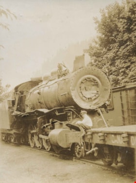
CPR Engine after falling over an embankment
https://search.heritageburnaby.ca/link/archivedescription34364
- Repository
- City of Burnaby Archives
- Date
- July 1925
- Collection/Fonds
- Burnaby Historical Society fonds
- Description Level
- Item
- Physical Description
- 1 photograph : b&w ; 6.6 x 8.9 cm on page 17.4 x 26.5 cm
- Scope and Content
- Photograph of a railroad car standing on the tracks. An unidentified boy is sitting on the train which has been identified by the caption as a Canadian Pacific Railway engine that fell over a bank at Cisco. This photograph appears to have been taken by Arthur Peers, who travelled through the Frase…
- Repository
- City of Burnaby Archives
- Date
- July 1925
- Collection/Fonds
- Burnaby Historical Society fonds
- Subseries
- Peers family subseries
- Physical Description
- 1 photograph : b&w ; 6.6 x 8.9 cm on page 17.4 x 26.5 cm
- Description Level
- Item
- Record No.
- 020-071
- Access Restriction
- No restrictions
- Reproduction Restriction
- No known restrictions
- Accession Number
- BHS2007-04
- Scope and Content
- Photograph of a railroad car standing on the tracks. An unidentified boy is sitting on the train which has been identified by the caption as a Canadian Pacific Railway engine that fell over a bank at Cisco. This photograph appears to have been taken by Arthur Peers, who travelled through the Fraser River Valley and worked on the construction of the Trans-Provincial Highway during the later 1920s.
- Media Type
- Photograph
- Photographer
- Peers, Arthur Francis "Mike"
- Notes
- Title based on caption accompanying photograph
Images

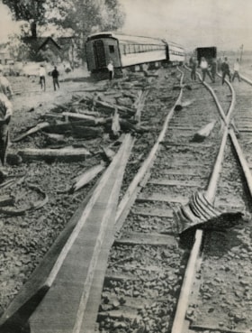
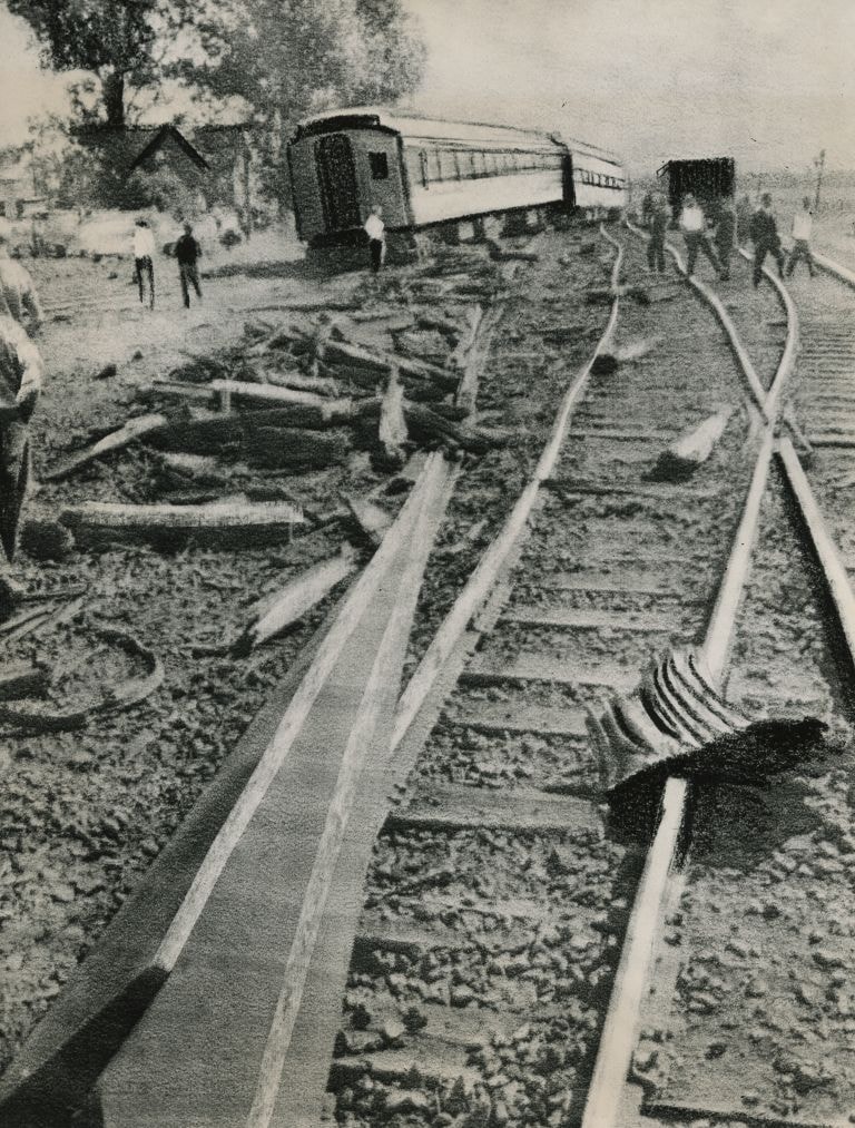
CPR passenger train wreckage in Ontario
https://search.heritageburnaby.ca/link/archivedescription45211
- Repository
- City of Burnaby Archives
- Date
- August 21, 1964, published August 21, 1964
- Collection/Fonds
- Columbian Newspaper collection
- Description Level
- Item
- Physical Description
- 1 photograph : b&w ; 24.5 x 18.5 cm
- Scope and Content
- Photograph of twisted rails and uprooted railway ties from an accident involving a Canadian Pacific Railway passenger train in Ontario. Eight were killed and fifteen were injured when a gravel truck collided with the passenger train and derailed it at a grade crossing near Ottawa. One of the many w…
- Repository
- City of Burnaby Archives
- Date
- August 21, 1964, published August 21, 1964
- Collection/Fonds
- Columbian Newspaper collection
- Physical Description
- 1 photograph : b&w ; 24.5 x 18.5 cm
- Description Level
- Item
- Record No.
- 480-097
- Access Restriction
- No restrictions
- Reproduction Restriction
- Reproduce for fair dealing purposes only
- Accession Number
- 2003-02
- Scope and Content
- Photograph of twisted rails and uprooted railway ties from an accident involving a Canadian Pacific Railway passenger train in Ontario. Eight were killed and fifteen were injured when a gravel truck collided with the passenger train and derailed it at a grade crossing near Ottawa. One of the many wounded was Burnaby school teacher; sculpture and painter Jack Hardman.
- Media Type
- Photograph
- Photographer
- United Press International (UPI) Radio Telephoto
- Notes
- Title based on contents of photograph
Images
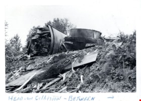
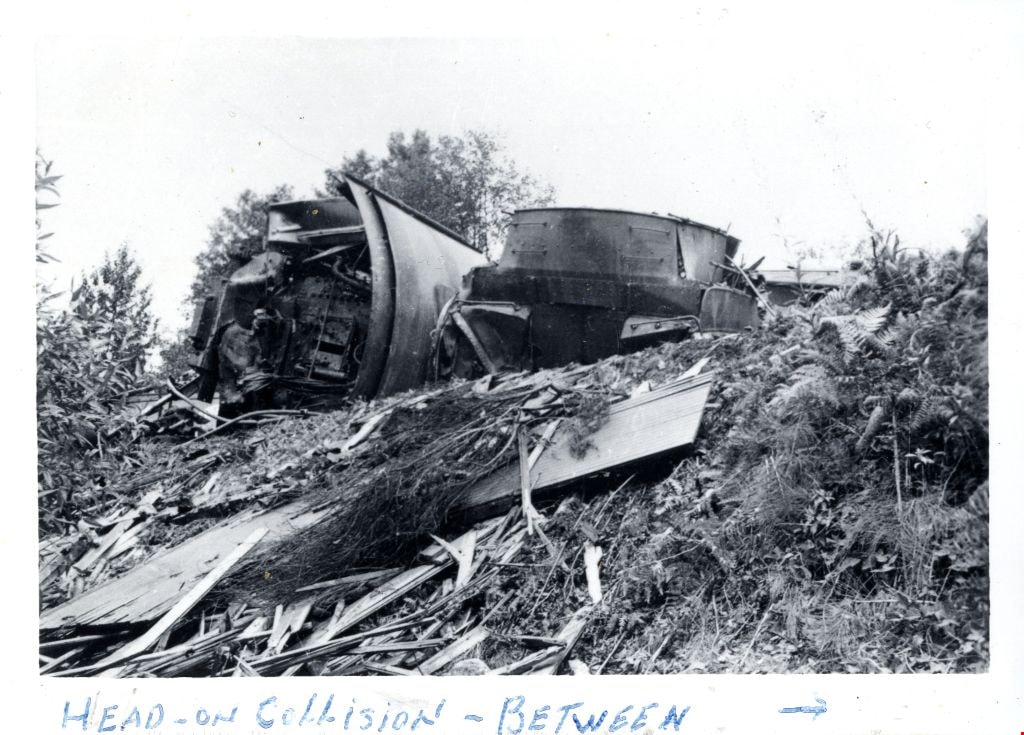
Train wreck
https://search.heritageburnaby.ca/link/archivedescription74184
- Repository
- City of Burnaby Archives
- Date
- July 1941
- Collection/Fonds
- Gordon McDonald collection
- Description Level
- Item
- Physical Description
- 1 photograph : b&w ; 8 x 11.5 cm
- Scope and Content
- Photograph of the aftermath of a train wreck that took place in the North Road cut due to a head-on collision between Canadian National Railway (CNR) and Great Northern Railway (GNR) trains.
- Repository
- City of Burnaby Archives
- Date
- July 1941
- Collection/Fonds
- Gordon McDonald collection
- Physical Description
- 1 photograph : b&w ; 8 x 11.5 cm
- Description Level
- Item
- Record No.
- 542-001
- Access Restriction
- No restrictions
- Reproduction Restriction
- No known restrictions
- Accession Number
- 2012-23
- Scope and Content
- Photograph of the aftermath of a train wreck that took place in the North Road cut due to a head-on collision between Canadian National Railway (CNR) and Great Northern Railway (GNR) trains.
- Subjects
- Accidents - Train Accidents
- Media Type
- Photograph
- Notes
- Title based on contents of photograph
- Note in pen on border (recto) of photograph reads: "Head-On Collision - Between - "
Images
Train wreck
https://search.heritageburnaby.ca/link/archivedescription74185
- Repository
- City of Burnaby Archives
- Date
- July 1941
- Collection/Fonds
- Gordon McDonald collection
- Description Level
- Item
- Physical Description
- 1 photograph : b&w ; 8 x 11.5 cm
- Scope and Content
- Photograph of the aftermath of a train wreck that took place in the North Road cut due to a head-on collision between Canadian National Railway (CNR) and Great Northern Railway (GNR) trains.
- Repository
- City of Burnaby Archives
- Date
- July 1941
- Collection/Fonds
- Gordon McDonald collection
- Physical Description
- 1 photograph : b&w ; 8 x 11.5 cm
- Description Level
- Item
- Record No.
- 542-002
- Access Restriction
- No restrictions
- Reproduction Restriction
- No known restrictions
- Accession Number
- 2012-23
- Scope and Content
- Photograph of the aftermath of a train wreck that took place in the North Road cut due to a head-on collision between Canadian National Railway (CNR) and Great Northern Railway (GNR) trains.
- Subjects
- Accidents - Train Accidents
- Media Type
- Photograph
- Notes
- Title based on contents of photograph
- Note in pen on border (recto) of photograph reads: "CNR + GNR - July [?]4, 41"
Images
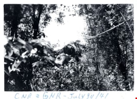
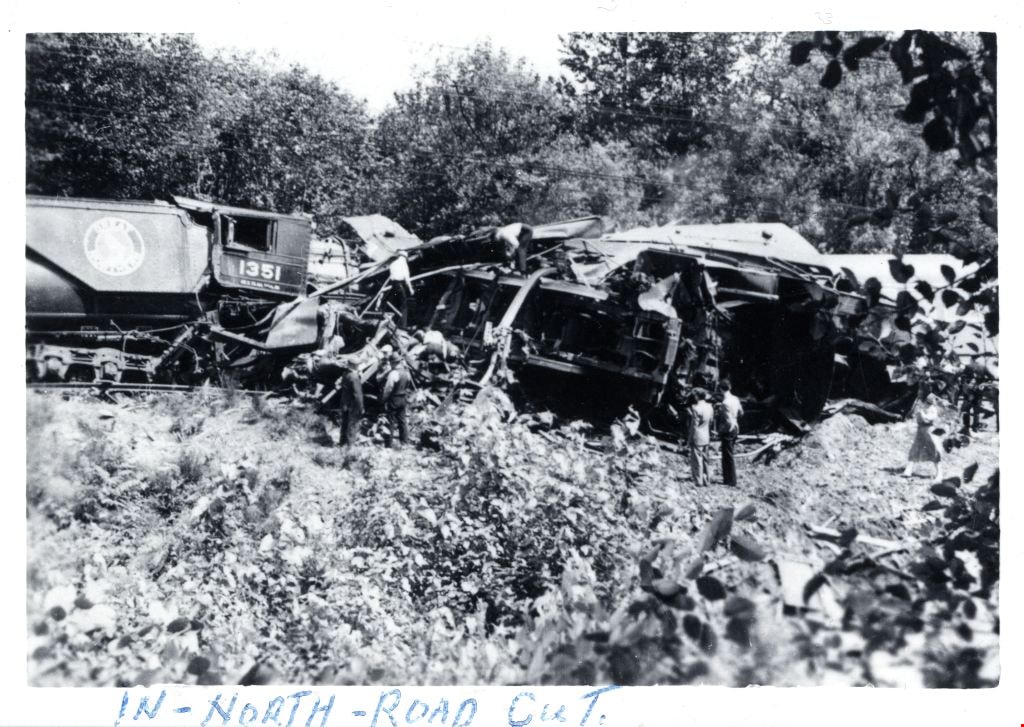
Train wreck
https://search.heritageburnaby.ca/link/archivedescription74186
- Repository
- City of Burnaby Archives
- Date
- July 1941
- Collection/Fonds
- Gordon McDonald collection
- Description Level
- Item
- Physical Description
- 1 photograph : b&w ; 8 x 11.5 cm
- Scope and Content
- Photograph of a group of people viewing the aftermath of a train wreck that took place in the North Road cut due to a head-on collision between Canadian National Railway (CNR) and Great Northern Railway (GNR) trains.
- Repository
- City of Burnaby Archives
- Date
- July 1941
- Collection/Fonds
- Gordon McDonald collection
- Physical Description
- 1 photograph : b&w ; 8 x 11.5 cm
- Description Level
- Item
- Record No.
- 542-003
- Access Restriction
- No restrictions
- Reproduction Restriction
- No known restrictions
- Accession Number
- 2012-23
- Scope and Content
- Photograph of a group of people viewing the aftermath of a train wreck that took place in the North Road cut due to a head-on collision between Canadian National Railway (CNR) and Great Northern Railway (GNR) trains.
- Subjects
- Accidents - Train Accidents
- Media Type
- Photograph
- Notes
- Title based on contents of photograph
- Note in pen on border (recto) of photograph reads: "In - North - Road Cut."
Images
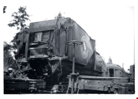
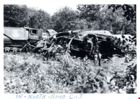
Train wreck
https://search.heritageburnaby.ca/link/archivedescription74187
- Repository
- City of Burnaby Archives
- Date
- July 1941
- Collection/Fonds
- Gordon McDonald collection
- Description Level
- Item
- Physical Description
- 1 photograph : b&w ; 8 x 11.5 cm
- Scope and Content
- Photograph of a Great Northern Railway train-car damaged from a train wreck that took place in the North Road cut. This was a head-on collision between Canadian National Railway (CNR) and Great Northern Railway (GNR) trains.
- Repository
- City of Burnaby Archives
- Date
- July 1941
- Collection/Fonds
- Gordon McDonald collection
- Physical Description
- 1 photograph : b&w ; 8 x 11.5 cm
- Description Level
- Item
- Record No.
- 542-004
- Access Restriction
- No restrictions
- Reproduction Restriction
- No known restrictions
- Accession Number
- 2012-23
- Scope and Content
- Photograph of a Great Northern Railway train-car damaged from a train wreck that took place in the North Road cut. This was a head-on collision between Canadian National Railway (CNR) and Great Northern Railway (GNR) trains.
- Subjects
- Accidents - Train Accidents
- Media Type
- Photograph
- Notes
- Title based on contents of photograph
Images
