More like 'Central Park Pharmacy'
Narrow Results By
Subject
- Accidents - Automobile Accidents 1
- Advertising Medium 3
- Advertising Medium - Signs and Signboards 81
- Aerial Photographs 26
- Agricultural Tools and Equipment - Plows 3
- Agriculture 2
- Agriculture - Crops 2
- Agriculture - Farms 48
- Agriculture - Fruit and Berries 5
- Agriculture - Poultry 4
- Animals - Birds 2
- Animals - Cats 5
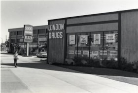
London Drugs
https://search.heritageburnaby.ca/link/archivedescription79153
- Repository
- City of Burnaby Archives
- Date
- September 15, 1976
- Collection/Fonds
- Burnaby Public Library Contemporary Visual Archive Project
- Description Level
- Item
- Physical Description
- 1 photograph : b&w ; 11 x 16 cm mounted on cardboard
- Scope and Content
- Photograph shows London Drugs store in the Kingsway Plaza in the 5000 Block Kingsway.
- Repository
- City of Burnaby Archives
- Date
- September 15, 1976
- Collection/Fonds
- Burnaby Public Library Contemporary Visual Archive Project
- Physical Description
- 1 photograph : b&w ; 11 x 16 cm mounted on cardboard
- Description Level
- Item
- Record No.
- 556-177
- Access Restriction
- No restrictions
- Reproduction Restriction
- Reproduce for fair dealing purposes only
- Accession Number
- 2013-13
- Scope and Content
- Photograph shows London Drugs store in the Kingsway Plaza in the 5000 Block Kingsway.
- Names
- London Drugs
- Media Type
- Photograph
- Photographer
- McCarron, John
- Notes
- Scope note taken directly from BPL photograph description.
- 1 b&w copy negative : 10 x 12.5 cm accompanying
- Geographic Access
- Kingsway
- Street Address
- 5000 Kingsway
- Historic Neighbourhood
- Central Park (Historic Neighbourhood)
- Planning Study Area
- Marlborough Area
Images

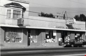
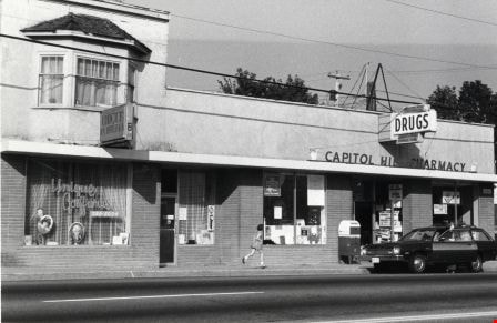
Unique Coiffures
https://search.heritageburnaby.ca/link/archivedescription79198
- Repository
- City of Burnaby Archives
- Date
- October 16, 1976
- Collection/Fonds
- Burnaby Public Library Contemporary Visual Archive Project
- Description Level
- Item
- Physical Description
- 1 photograph : b&w ; 11 x 16 cm mounted on cardboard
- Scope and Content
- Photograph shows Unique Coiffures at 5525 Hastings Street and the Capitol Hill Pharmacy at 5527 Hastings Street.
- Repository
- City of Burnaby Archives
- Date
- October 16, 1976
- Collection/Fonds
- Burnaby Public Library Contemporary Visual Archive Project
- Physical Description
- 1 photograph : b&w ; 11 x 16 cm mounted on cardboard
- Description Level
- Item
- Record No.
- 556-202
- Access Restriction
- No restrictions
- Reproduction Restriction
- Reproduce for fair dealing purposes only
- Accession Number
- 2013-13
- Scope and Content
- Photograph shows Unique Coiffures at 5525 Hastings Street and the Capitol Hill Pharmacy at 5527 Hastings Street.
- Media Type
- Photograph
- Notes
- Scope note taken directly from BPL photograph description.
- 1 b&w copy negative : 10 x 12.5 cm accompanying
- Photographers identified by surnames only: Carr and Vardeman
- Geographic Access
- Hastings Street
- Street Address
- 5525 Hastings Street
- 5527 Hastings Street
- Historic Neighbourhood
- Capitol Hill (Historic Neighbourhood)
- Planning Study Area
- Capitol Hill Area
Images
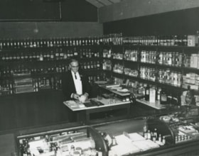
Burnaby Village Museum Drug Store
https://search.heritageburnaby.ca/link/archivedescription35948
- Repository
- City of Burnaby Archives
- Date
- 1974
- Collection/Fonds
- Burnaby Historical Society fonds
- Description Level
- Item
- Physical Description
- 1 photograph : b&w
- Scope and Content
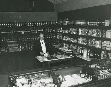
- Photograph of Bernie Bellinger in the Burnaby Village Museum Drug Store.
- Repository
- City of Burnaby Archives
- Date
- 1974
- Collection/Fonds
- Burnaby Historical Society fonds
- Subseries
- Bernard Bellinger subseries
- Physical Description
- 1 photograph : b&w
- Description Level
- Item
- Record No.
- 205-001
- Access Restriction
- No restrictions
- Reproduction Restriction
- Reproduce for fair dealing purposes only
- Accession Number
- BHS1988-04
- Scope and Content
- Photograph of Bernie Bellinger in the Burnaby Village Museum Drug Store.
- Subjects
- Buildings - Commercial - Drugstores
- Names
- Bellinger, Bernard
- Media Type
- Photograph
- Notes
- Title based on contents of photograph
- Geographic Access
- Deer Lake Avenue
- Street Address
- 6501 Deer Lake Avenue
- Historic Neighbourhood
- Burnaby Lake (Historic Neighbourhood)
- Planning Study Area
- Morley-Buckingham Area
Images

Central Park Pharmacy
https://search.heritageburnaby.ca/link/archivedescription35024
- Repository
- City of Burnaby Archives
- Date
- July 1986
- Collection/Fonds
- Burnaby Historical Society fonds
- Description Level
- Item
- Physical Description
- 1 photograph : b&w ; 8.8 x 12.5 cm
- Scope and Content
- Photograph of the exterior of the Central Park Pharmacy and Post Office, 3967 Kingsway at Jersey Avenue. Signs read, "Central Park Pharmacy," "Post Office," and "Drugs." A view east down Kingsway can be seen on the right side of the photo. There is an automobile parked on the street, a firehydra…
- Repository
- City of Burnaby Archives
- Date
- July 1986
- Collection/Fonds
- Burnaby Historical Society fonds
- Subseries
- Evelyn Salisbury subseries
- Physical Description
- 1 photograph : b&w ; 8.8 x 12.5 cm
- Description Level
- Item
- Record No.
- 177-001
- Access Restriction
- No restrictions
- Reproduction Restriction
- Reproduce for fair dealing purposes only
- Accession Number
- BHS1986-25
- Scope and Content
- Photograph of the exterior of the Central Park Pharmacy and Post Office, 3967 Kingsway at Jersey Avenue. Signs read, "Central Park Pharmacy," "Post Office," and "Drugs." A view east down Kingsway can be seen on the right side of the photo. There is an automobile parked on the street, a firehydrant in the left corner of the photo, and apartment buildings in the background.
- Subjects
- Buildings - Commercial - Drugstores
- Names
- Central Park Pharmacy
- Media Type
- Photograph
- Notes
- Title based on contents of photograph
- Geographic Access
- Kingsway
- Jersey Avenue
- Street Address
- 3967 Kingsway
- Historic Neighbourhood
- Central Park (Historic Neighbourhood)
- Planning Study Area
- Garden Village Area
Images


Central Park Pharmacy
https://search.heritageburnaby.ca/link/archivedescription35026
- Repository
- City of Burnaby Archives
- Date
- July 1986
- Collection/Fonds
- Burnaby Historical Society fonds
- Description Level
- Item
- Physical Description
- 1 photograph : b&w ; 12.5 x 8.8 cm
- Scope and Content
- Photograph of the Central Park Pharmacy and Post Office, 3967 Kingsway at Jersey Avenue, with Mr. Chan, the pharmacist, standing outside. Some of the signs on the store read, "Central Park Pharmacy," "Post Office," "Drugs," "Visa," and "On Sale Here." A view east down Kingsway can be seen on the …
- Repository
- City of Burnaby Archives
- Date
- July 1986
- Collection/Fonds
- Burnaby Historical Society fonds
- Subseries
- Evelyn Salisbury subseries
- Physical Description
- 1 photograph : b&w ; 12.5 x 8.8 cm
- Description Level
- Item
- Record No.
- 177-003
- Access Restriction
- No restrictions
- Reproduction Restriction
- Reproduce for fair dealing purposes only
- Accession Number
- BHS1986-25
- Scope and Content
- Photograph of the Central Park Pharmacy and Post Office, 3967 Kingsway at Jersey Avenue, with Mr. Chan, the pharmacist, standing outside. Some of the signs on the store read, "Central Park Pharmacy," "Post Office," "Drugs," "Visa," and "On Sale Here." A view east down Kingsway can be seen on the right side of the photograph. Cars are visible on the street. A sign further down Kingsway reads, "TV: Tele-Peter." The street sign reads, "Jersey Ave 5600."
- Names
- Central Park Pharmacy
- Media Type
- Photograph
- Notes
- Title based on contents of photograph
- Geographic Access
- Kingsway
- Jersey Avenue
- Street Address
- 3967 Kingsway
- Historic Neighbourhood
- Central Park (Historic Neighbourhood)
- Planning Study Area
- Garden Village Area
Images

Drug Store on Hastings
https://search.heritageburnaby.ca/link/archivedescription79126
- Repository
- City of Burnaby Archives
- Date
- October, 1976
- Collection/Fonds
- Burnaby Public Library Contemporary Visual Archive Project
- Description Level
- Item
- Physical Description
- 1 photograph : b&w ; 11 x 16 cm mounted on cardboard
- Scope and Content
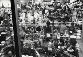
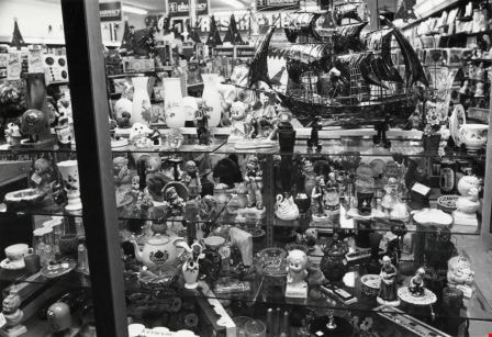
- Photograph shows gifts and novelties in the window of a drug store on Hastings Street.
- Repository
- City of Burnaby Archives
- Date
- October, 1976
- Collection/Fonds
- Burnaby Public Library Contemporary Visual Archive Project
- Physical Description
- 1 photograph : b&w ; 11 x 16 cm mounted on cardboard
- Description Level
- Item
- Record No.
- 556-169
- Access Restriction
- No restrictions
- Reproduction Restriction
- Reproduce for fair dealing purposes only
- Accession Number
- 2013-13
- Scope and Content
- Photograph shows gifts and novelties in the window of a drug store on Hastings Street.
- Subjects
- Buildings - Commercial - Drugstores
- Media Type
- Photograph
- Photographer
- Cook, Alan
- Notes
- Scope note taken directly from BPL photograph description.
- 1 b&w copy negative : 10 x 12.5 cm accompanying
- Geographic Access
- Hastings Street
- Historic Neighbourhood
- Vancouver Heights (Historic Neighbourhood)
- Planning Study Area
- Willingdon Heights Area
Images
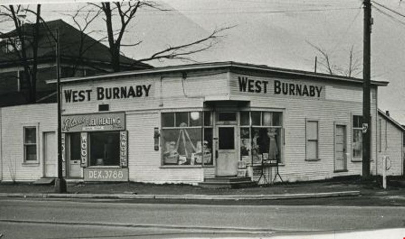
George's Pharmacy
https://search.heritageburnaby.ca/link/archivedescription35175
- Repository
- City of Burnaby Archives
- Date
- 1951 (date of original), copied 1986
- Collection/Fonds
- Burnaby Historical Society fonds
- Description Level
- Item
- Physical Description
- 1 photograph : b&w ; 12.7 x 17.8 cm print
- Scope and Content
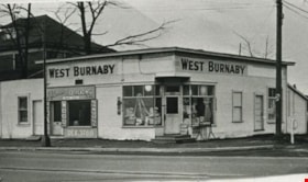
- Photograph of the West Burnaby Pharmacy building on the corner of Kingsway and Sussex Avenue (4687 Kingsway). Miss Wilhelmina "Willie" George was pharmacist there for many years. The store was a hangout for Kingsway West students who stopped by for candies and soft drinks. The old George family …
- Repository
- City of Burnaby Archives
- Date
- 1951 (date of original), copied 1986
- Collection/Fonds
- Burnaby Historical Society fonds
- Subseries
- Pioneer Tales subseries
- Physical Description
- 1 photograph : b&w ; 12.7 x 17.8 cm print
- Description Level
- Item
- Record No.
- 204-032
- Access Restriction
- No restrictions
- Reproduction Restriction
- Reproduce for fair dealing purposes only
- Accession Number
- BHS1988-03
- Scope and Content
- Photograph of the West Burnaby Pharmacy building on the corner of Kingsway and Sussex Avenue (4687 Kingsway). Miss Wilhelmina "Willie" George was pharmacist there for many years. The store was a hangout for Kingsway West students who stopped by for candies and soft drinks. The old George family home can be seen on the left.
- Subjects
- Buildings - Commercial - Drugstores
- Names
- West Burnaby Pharmacy
- Media Type
- Photograph
- Notes
- Title based on contents of photograph
- Geographic Access
- Kingsway
- Street Address
- 4687 Kingsway
- Historic Neighbourhood
- Central Park (Historic Neighbourhood)
- Planning Study Area
- Marlborough Area
Images

Heyworth family
https://search.heritageburnaby.ca/link/archivedescription35072
- Repository
- City of Burnaby Archives
- Date
- 1939 (date of original), copied 1986
- Collection/Fonds
- Burnaby Historical Society fonds
- Description Level
- Item
- Physical Description
- 1 photograph : b&w negative ; 9.0 x 6.0 cm
- Scope and Content
- Photograph of Mr. and Mrs. [G.R.] Heyworth and "Aunt Betty" outside standing outside Jubilee Drug Store, Jubilee Avenue and Imperial Street (later the location of Bonsor Park, 6550 Bonsor Avenue). An electric sign reads, "Rexall Drugs." A dog can be seen at the bottom of the photograph. An accom…
- Repository
- City of Burnaby Archives
- Date
- 1939 (date of original), copied 1986
- Collection/Fonds
- Burnaby Historical Society fonds
- Subseries
- Heyworth family subseries
- Physical Description
- 1 photograph : b&w negative ; 9.0 x 6.0 cm
- Description Level
- Item
- Record No.
- 187-005
- Access Restriction
- No restrictions
- Reproduction Restriction
- No known restrictions
- Accession Number
- BHS1986-38
- Scope and Content
- Photograph of Mr. and Mrs. [G.R.] Heyworth and "Aunt Betty" outside standing outside Jubilee Drug Store, Jubilee Avenue and Imperial Street (later the location of Bonsor Park, 6550 Bonsor Avenue). An electric sign reads, "Rexall Drugs." A dog can be seen at the bottom of the photograph. An accompanying letter describes the photo as "Dad with Mother and Aunt Betty. They had just walked back from Kingsway after seeing the King and Queen pass - 1937 [sic; the royal visit was in 1939]."
- Subjects
- Animals - Dogs
- Buildings - Commercial - Drugstores
- Advertising Medium - Signs and Signboards
- Media Type
- Photograph
- Notes
- Title based on contents of photograph
- 1 b&w copy print accompanying
- Geographic Access
- Jubilee Avenue
- Bonsor Avenue
- Street Address
- 6550 Bonsor Avenue
- Historic Neighbourhood
- Central Park (Historic Neighbourhood)
- Planning Study Area
- Marlborough Area
Images

![Jubilee Drug Store, [1918] thumbnail](/media/hpo/_Data/_Archives_Images/_Unrestricted/126/187-001.jpg?width=280)
Jubilee Drug Store
https://search.heritageburnaby.ca/link/archivedescription35068
- Repository
- City of Burnaby Archives
- Date
- [1918]
- Collection/Fonds
- Burnaby Historical Society fonds
- Description Level
- Item
- Physical Description
- 1 photograph : b&w ; 8.8 x 12.6 cm print
- Scope and Content
- Photograph of the exterior of Jubilee Drug Store, Jubilee Avenue and Imperial Street (later the location of Bonsor Park, 6550 Bonsor Avenue). Signs on the front of the store read, "Jubilee Drug Store / Drugs / Prescriptions / Lending Library / The Rexall Store." Signs on the side of the building …
- Repository
- City of Burnaby Archives
- Date
- [1918]
- Collection/Fonds
- Burnaby Historical Society fonds
- Subseries
- Heyworth family subseries
- Physical Description
- 1 photograph : b&w ; 8.8 x 12.6 cm print
- Description Level
- Item
- Record No.
- 187-001
- Access Restriction
- No restrictions
- Reproduction Restriction
- No known restrictions
- Accession Number
- BHS1986-38
- Scope and Content
- Photograph of the exterior of Jubilee Drug Store, Jubilee Avenue and Imperial Street (later the location of Bonsor Park, 6550 Bonsor Avenue). Signs on the front of the store read, "Jubilee Drug Store / Drugs / Prescriptions / Lending Library / The Rexall Store." Signs on the side of the building read, "Jubilee Drug Store / Films / Magazines / Violin Strings / Sargon / Puretest Drugs / Rexall Drug Store / NYAL Service Drugstore / Lending Library." A man is standing outside the store (this may be Mr. G.R. Heyworth).
- Names
- Jubilee Drug Store
- Media Type
- Photograph
- Notes
- Title based on contents of photograph
- Geographic Access
- Jubilee Avenue
- Bonsor Avenue
- Street Address
- 6550 Bonsor Avenue
- Historic Neighbourhood
- Central Park (Historic Neighbourhood)
- Planning Study Area
- Marlborough Area
Images
![Jubilee Drug Store, [1918] thumbnail](/media/hpo/_Data/_Archives_Images/_Unrestricted/126/187-001.jpg)

Out of Stock
https://search.heritageburnaby.ca/link/archivedescription95125
- Repository
- City of Burnaby Archives
- Date
- April 10, 2020
- Collection/Fonds
- Burnaby Photographic Society fonds
- Description Level
- Item
- Physical Description
- 1 photograph (tiff)
- Scope and Content
- Photograph of a sign in the window of a Pharmasave drugstore advertising the supplies it has available. The sign features "yes" and "no" columns with velcro patches to which checkmarks and crosses are stuck to to indicate which supplies are currently in stock. Supplies listed include: face masks,…
- Repository
- City of Burnaby Archives
- Date
- April 10, 2020
- Collection/Fonds
- Burnaby Photographic Society fonds
- Physical Description
- 1 photograph (tiff)
- Description Level
- Item
- Record No.
- 623-043
- Access Restriction
- No restrictions
- Reproduction Restriction
- Reproduce for fair dealing purposes only
- Accession Number
- 2020-10
- Scope and Content
- Photograph of a sign in the window of a Pharmasave drugstore advertising the supplies it has available. The sign features "yes" and "no" columns with velcro patches to which checkmarks and crosses are stuck to to indicate which supplies are currently in stock. Supplies listed include: face masks, hand sanitizer, hand soap, rubbing alcohol, thermometers, gloves, Lysol wipes, Tylenol, and toilet paper.
- Media Type
- Photograph
- Photographer
- Jerome, Ron
- Notes
- Transcribed title
- Geographic Access
- Hastings Street
- Street Address
- 4367 Hastings Street
- Historic Neighbourhood
- Vancouver Heights (Historic Neighbourhood)
- Planning Study Area
- Burnaby Heights Area
Images


Parkcrest Plaza
https://search.heritageburnaby.ca/link/archivedescription93653
- Repository
- City of Burnaby Archives
- Date
- October 23, 1977
- Collection/Fonds
- Burnaby Public Library Contemporary Visual Archive Project
- Description Level
- Item
- Physical Description
- 1 photograph : b&w ; 12.5 x 17.5 cm
- Scope and Content
- Photograph of the Parkcrest Plaza shopping centre at Sperling and Broadway. The photograph is taken from across the parking lot and lawn, facing west. Signs for the plaza's businesses include Fresh Foods and Bank of Nova Scotia, and homes and apartment buildings are in the distance.
- Repository
- City of Burnaby Archives
- Date
- October 23, 1977
- Collection/Fonds
- Burnaby Public Library Contemporary Visual Archive Project
- Physical Description
- 1 photograph : b&w ; 12.5 x 17.5 cm
- Description Level
- Item
- Record No.
- 556-610
- Access Restriction
- No restrictions
- Reproduction Restriction
- Reproduce for fair dealing purposes only
- Accession Number
- 2017-57
- Scope and Content
- Photograph of the Parkcrest Plaza shopping centre at Sperling and Broadway. The photograph is taken from across the parking lot and lawn, facing west. Signs for the plaza's businesses include Fresh Foods and Bank of Nova Scotia, and homes and apartment buildings are in the distance.
- Subjects
- Buildings - Commercial - Grocery Stores
- Buildings - Commercial - Malls
- Buildings - Commercial - Banks
- Buildings - Commercial - Stores
- Media Type
- Photograph
- Photographer
- Chapman, Fred
- Notes
- Title taken from project information form
- Accompanied by a project information form and 1 photograph (b&w negative ; 9.5 x 12.5 cm)
- BPL no. 60
- Geographic Access
- Sperling Avenue
- Broadway
- Street Address
- 5901 Sperling Avenue
- Planning Study Area
- Parkcrest-Aubrey Area
Images

7641-7651 Royal Oak Ave
https://search.heritageburnaby.ca/link/archivedescription93769
- Repository
- City of Burnaby Archives
- Date
- July 30, 1992
- Collection/Fonds
- Grover, Elliott & Co. Ltd. fonds
- Description Level
- File
- Physical Description
- 25 photographs : col. negatives ; 35 mm
- Scope and Content
- Photographs of the commercial properties located between 7641 and 7651 Royal Oak Avenue. Stores visible in the photographs include: Buy Low Foods, Mega Movies, and Chevron service station.
- Repository
- City of Burnaby Archives
- Date
- July 30, 1992
- Collection/Fonds
- Grover, Elliott & Co. Ltd. fonds
- Physical Description
- 25 photographs : col. negatives ; 35 mm
- Description Level
- File
- Record No.
- 622-053
- Access Restriction
- No restrictions
- Reproduction Restriction
- No restrictions
- Accession Number
- 2017-39
- Scope and Content
- Photographs of the commercial properties located between 7641 and 7651 Royal Oak Avenue. Stores visible in the photographs include: Buy Low Foods, Mega Movies, and Chevron service station.
- Subjects
- Buildings - Commercial
- Buildings - Commercial - Service Stations
- Buildings - Commercial - Stores
- Geographic Features - Roads
- Media Type
- Photograph
- Photographer
- Young, Richard
- Notes
- Transcribed title
- Title transcribed from envelope photographs were originally housed in
- File no. 92-287-B
- Geographic Access
- Royal Oak Avenue
- Historic Neighbourhood
- Alta Vista (Historic Neighbourhood)
- Planning Study Area
- Maywood Area

Burnaby Place
https://search.heritageburnaby.ca/link/archivedescription93691
- Repository
- City of Burnaby Archives
- Date
- June 4, 1978
- Collection/Fonds
- Burnaby Public Library Contemporary Visual Archive Project
- Description Level
- Item
- Physical Description
- 1 photograph : b&w ; 12.5 x 17.5 cm
- Scope and Content
- Photograph of a commercial mid-rise building at Patterson Avenue and Kingsway, near Central Park. A Shell gas station is next to the building and a Bank of Nova Scotia occupies the first floor. The photograph is taken from Patterson, facing east on Kingsway. Pedestrians are crossing at the intersec…
- Repository
- City of Burnaby Archives
- Date
- June 4, 1978
- Collection/Fonds
- Burnaby Public Library Contemporary Visual Archive Project
- Physical Description
- 1 photograph : b&w ; 12.5 x 17.5 cm
- Description Level
- Item
- Record No.
- 556-648
- Access Restriction
- No restrictions
- Reproduction Restriction
- Reproduce for fair dealing purposes only
- Accession Number
- 2017-57
- Scope and Content
- Photograph of a commercial mid-rise building at Patterson Avenue and Kingsway, near Central Park. A Shell gas station is next to the building and a Bank of Nova Scotia occupies the first floor. The photograph is taken from Patterson, facing east on Kingsway. Pedestrians are crossing at the intersection.
- Subjects
- Buildings - Commercial
- Buildings - Commercial - Service Stations
- Buildings - Commercial - Banks
- Media Type
- Photograph
- Photographer
- Chapman, Fred
- Notes
- Title taken from project information form
- Accompanied by a project information form and 1 photograph (b&w negative ; 9.5 x 12.5 cm)
- BPL no. 96
- Geographic Access
- Kingsway
- Central Park
- Patterson Avenue
- Historic Neighbourhood
- Central Park (Historic Neighbourhood)
- Planning Study Area
- Maywood Area
Images


Oh! Zhhu Sam
https://search.heritageburnaby.ca/link/archivedescription98681
- Repository
- City of Burnaby Archives
- Date
- 2022
- Collection/Fonds
- Disappearing Burnaby collection
- Description Level
- Item
- Physical Description
- 1 photograph (jpeg) : col.
- Scope and Content
- Photograph of the 7500 block of Edmonds Street at dusk. The photograph is taken from across Edmonds Street and depicts two commercial buildings: Oh! Zzhu Sam Korean Restaurant and the European Butcher Boy Delicatessen & Grocery. Oh! Zzhu Sam, located at 7506 Edmonds Street, was constructed in 1976.…
- Repository
- City of Burnaby Archives
- Date
- 2022
- Collection/Fonds
- Disappearing Burnaby collection
- Physical Description
- 1 photograph (jpeg) : col.
- Description Level
- Item
- Record No.
- 634-028
- Access Restriction
- No restrictions
- Reproduction Restriction
- No restrictions
- Accession Number
- 2022-14
- Scope and Content
- Photograph of the 7500 block of Edmonds Street at dusk. The photograph is taken from across Edmonds Street and depicts two commercial buildings: Oh! Zzhu Sam Korean Restaurant and the European Butcher Boy Delicatessen & Grocery. Oh! Zzhu Sam, located at 7506 Edmonds Street, was constructed in 1976. Residential houses border the restaurant and grocery store, and a bus shelter, municipal garbage can, and the restaurant's illuminated neon sign stand in front of the buildings.
- Subjects
- Buildings - Commercial
- Buildings - Commercial - Grocery Stores
- Buildings - Commercial - Restaurants
- Media Type
- Photograph
- Photographer
- Cheung, Nakita
- Notes
- Title taken from the associated blog post
- Associated blog post: https://disappearingburnaby.wordpress.com/2022/07/29/oh-zzhu-sam/
- Geographic Access
- Edmonds Street
- Street Address
- 7506 Edmonds Street
- Historic Neighbourhood
- Edmonds (Historic Neighbourhood)
- Planning Study Area
- Edmonds Area
Images


Trafalgar Market
https://search.heritageburnaby.ca/link/archivedescription98665
- Repository
- City of Burnaby Archives
- Date
- 2022
- Collection/Fonds
- Disappearing Burnaby collection
- Description Level
- Item
- Physical Description
- 1 photograph (jpeg) : col.
- Scope and Content
- Photograph of the intersection of Imperial Street and Sussex Avenue at night and in the rain. The photograph shows the Trafalgar Market grocery store (located at 4398 Imperial Street; the building was constructed in 1940) on the corner, with a large display of flowers for sale under the awning in f…
- Repository
- City of Burnaby Archives
- Date
- 2022
- Collection/Fonds
- Disappearing Burnaby collection
- Physical Description
- 1 photograph (jpeg) : col.
- Description Level
- Item
- Record No.
- 634-012
- Access Restriction
- No restrictions
- Reproduction Restriction
- No restrictions
- Accession Number
- 2022-14
- Scope and Content
- Photograph of the intersection of Imperial Street and Sussex Avenue at night and in the rain. The photograph shows the Trafalgar Market grocery store (located at 4398 Imperial Street; the building was constructed in 1940) on the corner, with a large display of flowers for sale under the awning in front of the store. The street and traffic lights are reflected in the puddles on the road, and cars and other businesses are visible along Imperial Street.
- Subjects
- Buildings - Commercial
- Buildings - Commercial - Grocery Stores
- Buildings - Commercial - Stores
- Geographic Features - Roads
- Media Type
- Photograph
- Photographer
- Cheung, Nakita
- Notes
- Title taken from the associated blog post
- Associated blog post: https://disappearingburnaby.wordpress.com/2022/02/20/imperial-manor-2/
- Geographic Access
- Imperial Street
- Sussex Avenue
- Street Address
- 4398 Imperial Street
- Historic Neighbourhood
- Central Park (Historic Neighbourhood)
- Planning Study Area
- Sussex-Nelson Area
Images

![3700 block of Hastings Street, [2000] thumbnail](/media/hpo/_Data/_Archives_Images/_Unrestricted/535/535-3066.jpg?width=280)
3700 block of Hastings Street
https://search.heritageburnaby.ca/link/archivedescription97940
- Repository
- City of Burnaby Archives
- Date
- [2000]
- Collection/Fonds
- Burnaby NewsLeader photograph collection
- Description Level
- Item
- Physical Description
- 1 photograph (tiff) : b&w
- Scope and Content
- Photograph of the 3700 block of Hastings Street in North Burnaby, looking southeast. Kato Japanese Chinese Restaurant is one of the visible businesses and some snow is on the ground.
- Repository
- City of Burnaby Archives
- Date
- [2000]
- Collection/Fonds
- Burnaby NewsLeader photograph collection
- Physical Description
- 1 photograph (tiff) : b&w
- Description Level
- Item
- Record No.
- 535-3066
- Access Restriction
- No restrictions
- Reproduction Restriction
- No restrictions
- Accession Number
- 2018-12
- Scope and Content
- Photograph of the 3700 block of Hastings Street in North Burnaby, looking southeast. Kato Japanese Chinese Restaurant is one of the visible businesses and some snow is on the ground.
- Subjects
- Geographic Features - Roads
- Buildings - Commercial
- Buildings - Commercial - Restaurants
- Buildings - Residential
- Media Type
- Photograph
- Notes
- Title based on contents of photograph
- Collected by editorial for use in a January 2000 issue of the Burnaby NewsLeader
- Geographic Access
- Hastings Street
- Street Address
- 3700 Hastings Street
- Historic Neighbourhood
- Vancouver Heights (Historic Neighbourhood)
- Planning Study Area
- Burnaby Heights Area
Images
![3700 block of Hastings Street, [2000] thumbnail](/media/hpo/_Data/_Archives_Images/_Unrestricted/535/535-3066.jpg)

Highrises on Kingsway
https://search.heritageburnaby.ca/link/archivedescription93692
- Repository
- City of Burnaby Archives
- Date
- June 4, 1978
- Collection/Fonds
- Burnaby Public Library Contemporary Visual Archive Project
- Description Level
- Item
- Physical Description
- 1 photograph : b&w ; 12.5 x 17.5 cm
- Scope and Content
- Photograph of high-rises apartment buildings and the neighbourhood along Kingsway by Central Park. The photograph is taken from a high point, facing east down Kingsway. The Central Park Veterinary Hospital, Central Park Place, a railway crossing, a gas station, and the Central Park Gate are visible…
- Repository
- City of Burnaby Archives
- Date
- June 4, 1978
- Collection/Fonds
- Burnaby Public Library Contemporary Visual Archive Project
- Physical Description
- 1 photograph : b&w ; 12.5 x 17.5 cm
- Description Level
- Item
- Record No.
- 556-649
- Access Restriction
- No restrictions
- Reproduction Restriction
- Reproduce for fair dealing purposes only
- Accession Number
- 2017-57
- Scope and Content
- Photograph of high-rises apartment buildings and the neighbourhood along Kingsway by Central Park. The photograph is taken from a high point, facing east down Kingsway. The Central Park Veterinary Hospital, Central Park Place, a railway crossing, a gas station, and the Central Park Gate are visible in the photograph.
- Subjects
- Buildings - Commercial
- Buildings - Residential - Apartments
- Buildings - Commercial - Service Stations
- Geographic Features - Parks
- Monuments
- Media Type
- Photograph
- Photographer
- Chapman, Fred
- Notes
- Title taken from project information form
- Accompanied by a project information form and 1 photograph (b&w negative ; 9.5 x 12.5 cm)
- BPL no. 97
- Geographic Access
- Kingsway
- Central Park
- Historic Neighbourhood
- Central Park (Historic Neighbourhood)
- Planning Study Area
- Maywood Area
Images


Old Orchard Shopping Centre
https://search.heritageburnaby.ca/link/archivedescription93602
- Repository
- City of Burnaby Archives
- Date
- October 9, 1977
- Collection/Fonds
- Burnaby Public Library Contemporary Visual Archive Project
- Description Level
- Item
- Physical Description
- 1 photograph : b&w ; 12.5 x 17.5 cm
- Scope and Content
- Photograph of the Old Orchard Shopping Centre, located at Kingsway and Willingdon. The photograph is taken from across the intersection, facing northwest, and shows an IGA and a high-rise apartment building in the background.
- Repository
- City of Burnaby Archives
- Date
- October 9, 1977
- Collection/Fonds
- Burnaby Public Library Contemporary Visual Archive Project
- Physical Description
- 1 photograph : b&w ; 12.5 x 17.5 cm
- Description Level
- Item
- Record No.
- 556-559
- Access Restriction
- No restrictions
- Reproduction Restriction
- Reproduce for fair dealing purposes only
- Accession Number
- 2017-57
- Scope and Content
- Photograph of the Old Orchard Shopping Centre, located at Kingsway and Willingdon. The photograph is taken from across the intersection, facing northwest, and shows an IGA and a high-rise apartment building in the background.
- Subjects
- Buildings - Commercial - Malls
- Buildings - Commercial - Grocery Stores
- Buildings - Residential - Apartments
- Media Type
- Photograph
- Photographer
- Chapman, Fred
- Notes
- Title taken from project information form
- Accompanied by a project information form and 1 photograph (b&w negative ; 9.5 x 12.5 cm)
- BPL no. 3
- Geographic Access
- Kingsway
- Street Address
- 4469 Kingsway
- Historic Neighbourhood
- Central Park (Historic Neighbourhood)
- Planning Study Area
- Maywood Area
Images

3355-3375 North Rd Burnaby
https://search.heritageburnaby.ca/link/archivedescription93891
- Repository
- City of Burnaby Archives
- Date
- June 1993
- Collection/Fonds
- Grover, Elliott & Co. Ltd. fonds
- Description Level
- File
- Physical Description
- 52 photographs : col. negatives ; 35 mm
- Scope and Content
- Photographs of the strip mall located at 3355-3375 North Road. Stores visible in the photographs include: CD Rentals and Laser Discs, Canadian 2-for-1 Pizza, Eyecrafters, North Road Dental Centre, Mike Fridays, and Penningtons.
- Repository
- City of Burnaby Archives
- Date
- June 1993
- Collection/Fonds
- Grover, Elliott & Co. Ltd. fonds
- Physical Description
- 52 photographs : col. negatives ; 35 mm
- Description Level
- File
- Record No.
- 622-074
- Access Restriction
- No restrictions
- Reproduction Restriction
- No restrictions
- Accession Number
- 2017-39
- Scope and Content
- Photographs of the strip mall located at 3355-3375 North Road. Stores visible in the photographs include: CD Rentals and Laser Discs, Canadian 2-for-1 Pizza, Eyecrafters, North Road Dental Centre, Mike Fridays, and Penningtons.
- Media Type
- Photograph
- Photographer
- Young, Richard
- Notes
- Transcribed title
- Title transcribed from envelope photographs were originally housed in
- File no. 93-273-B
- Geographic Access
- North Road
- Historic Neighbourhood
- Burquitlam (Historic Neighbourhood)
- Planning Study Area
- Lyndhurst Area
4775 Hastings St.
https://search.heritageburnaby.ca/link/archivedescription94340
- Repository
- City of Burnaby Archives
- Date
- October 1995
- Collection/Fonds
- Grover, Elliott & Co. Ltd. fonds
- Description Level
- File
- Physical Description
- 26 photographs : col. negatives ; 35 mm
- Scope and Content
- Photographs of a Pizza Hut restaurant located at 4775 Hastings Street and Honda and Toyota automotive dealerships located at 4780 Hastings Street.
- Repository
- City of Burnaby Archives
- Date
- October 1995
- Collection/Fonds
- Grover, Elliott & Co. Ltd. fonds
- Physical Description
- 26 photographs : col. negatives ; 35 mm
- Description Level
- File
- Record No.
- 622-125
- Access Restriction
- No restrictions
- Reproduction Restriction
- No restrictions
- Accession Number
- 2017-39
- Scope and Content
- Photographs of a Pizza Hut restaurant located at 4775 Hastings Street and Honda and Toyota automotive dealerships located at 4780 Hastings Street.
- Media Type
- Photograph
- Notes
- Transcribed title
- Title transcribed from envelope photographs were originally housed in
- File no. 95-247-B
- Geographic Access
- Hastings Street
- Street Address
- 4775 Hastings Street
- Historic Neighbourhood
- Capitol Hill (Historic Neighbourhood)
- Planning Study Area
- Capitol Hill Area